
| OCEANA NAS /APOLLO SOUCEK FLD VIRGINIA BEACH VA |
| |
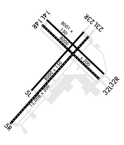
| Lat: N 3649.4 Long: W 07601.9 Elev: 22 Var: +10 Longest Runway: 12008 | ||
| Clr Del: 254.4 Dept. ATIS: 317.6 Arr. ATIS: 317.6 Ground: 336.4 Tower: 127.07 | ||
| ||||||||||||||||||||||||||||||||
| ||||||||||||||||||||||||||||||||
| ||||||||||||||||||||||||||||||||
| Rwy | Rwy | |||||||
| 8000x150 | 8000' | 8000x150 | 8000' | |||||
| 12008x200 | 12008' | 12008x200 | 12008' | |||||
| 8001x150 | 8001' | 8001x150 | 8001' | |||||
| 8000x200 | 8000' | 8000x200 | 8000' | |||||
| Runway ID | Single Wheel | Double Wheel | Double Tandem Wheel | Dual Double Wheel |
| 05L/23R | N/A | N/A | N/A | N/A |
| 05R/23L | N/A | N/A | N/A | N/A |
| 14L/32R | N/A | N/A | N/A | N/A |
| 14R/32L | N/A | N/A | N/A | N/A |
| These numbers are Advisory and are not limits. The Airport Manager should have more accurate Weight Limits | ||||
 Airport Diagram might not be current. | |
| Facility Name: | OCEANA NAS /APOLLO SOUCEK FLD |
| City Name: | VIRGINIA BEACH |
| County: | VIRGINIA BEACH |
| State abbrev: | VA |
| State Name: | VIRGINIA |
| Ownership: | NAVY OWNED |
| Use: | PRIVATE |
| Owner's Name: | U.S. NAVY |
| Address: | OCEANOGRAPHIC OFC-CODE 3142 |
| WASHINGTON, DC 20373 | |
| Owner's Phone: | |
| Manager's Name: | COMMANDING OFFICER |
| Address: | NAVAL AIR STATION OCEANA |
| VIRGINIA BEACH, VA 23460 | |
| Phone: | |
| FAA Region: | EASTERN |
| FAA Field Office: | DCA |

| Date | Sunrise | Sunset |
|---|---|---|
| 09/24/21 Friday | 6:53 | 18:58 |
| 09/25/21 Saturday | 6:54 | 18:57 |
| 09/26/21 Sunday | 6:55 | 18:55 |
| 09/27/21 Monday | 6:56 | 18:54 |
| 09/28/21 Tuesday | 6:57 | 18:52 |
| 09/29/21 Wednesday | 6:57 | 18:51 |
| 09/30/21 Thursday | 6:58 | 18:49 |
| 10/01/21 Friday | 6:59 | 18:48 |
| 10/02/21 Saturday | 7:00 | 18:46 |
| 10/03/21 Sunday | 7:01 | 18:45 |
| 10/04/21 Monday | 7:02 | 18:43 |
| 10/05/21 Tuesday | 7:03 | 18:42 |
| 10/06/21 Wednesday | 7:03 | 18:41 |
| 10/07/21 Thursday | 7:04 | 18:39 |
| Airport Attendance Schedule | CONTINUOUS |
| Airport Status | OPERATIONAL (This Status can change at any time - please check NOTAMS) |
| Airport Lighting Schedule | AVBL ONLY DURING HRS OF OPERATION. |
| Airport Storage Available | NONE |
| Extra Services Available | NONE |
| Wind Indicator | NONE |
| Control Tower | YES |
| CTAF Frequency | |
| Unicom Frequency | |
| Rotating Beacon Color | SPLIT-CLEAR-GREEN (LIGHTED MILITARY AIRPORT) |
| Segmented Circle | NO |
| Landing Fee |
| Airport Inspected | No Inspection Data Available performed by the OWNER |
| Inspection Date | Unknown |
| Type of Fuel Available | None |
| Airframe Repair Service | None |
| Power Plant Repair Service | None |
| Latitude | N3649.4 |
| Longitude | W07601.9 (ESTIMATED) |
| Arpt Elevation | 22ft (SURVEYED) |
| Magnetic Variation | 10W |
| 3 miles SW | of VIRGINIA BEACH |
| Traffic Pattern Altitude | |
| Sectional Chart | WASHINGTON |
| Operations (Reported) | Yearly | Avg. Daily |
|---|---|---|
| General Aviation Transient | 0 | 0 |
| General Aviation Local | 0 | 0 |
| Air Taxi | 0 | 0 |
| Commerical | 0 | 0 |
| Commuter | 0 | 0 |
| Military | 0 | 0 |
| Aircraft based on Field | |
|---|---|
| General Aviation Singles | 0 |
| General Aviation Multi | 0 |
| Jet Aircraft | 0 |
| General Aviation Helicopters | 0 |
| Military Aircraft | 0 |
| Gliders | 0 |
| Ultralights | 0 |
| FSS on field | NO |
| FSS tie-in | LEESBURG |
| FSS Phone | |
| Who issues Notams | NTU |
| Notam D service at airport | YES |
| ARTCC Name | WASHINGTON |
| Airport Certification | |
| Aircraft Rescue & Firefighting Index | None |
| Airport of Entry | No |
| Custom Landing Rights | No |
| Joint Civil/Military | No |
| Military Landing rights | No |
| SERVICE-A-GEAR: A-G NML RIGGED ALL RWY EXC INBOARD RWY SHORTFIELD ARRESTING GEAR. |
| NS ABTMT: STRICT COMPLIANCE RQR WITH PROGRAM OUTLINED IN FLIP AP/1 SUPPLEMENTARY ARPT |
| CSTMS/AG/IMG: AVBL OCEANA NAS BASED TACTICAL ACFT ONLY. RQR 48 HR PN TO BASE OPS. AIRCREW RQR TO REMAIN IN ACFT TIL RELEASED BY CSTMS. |
| TWY A3, FEEDER TWY FROM A TWY TO RAMP AREA, 1ST FEEDER TWY SOUTH OF FUEL PITS. |
| HANGAR 145 AND REVISE RAMP AREA EXTENDING SE CORNER OF RAMP FROM JUST SOUTH OF FUEL PITS TO APPROXIMATELY THE END OF THE OVER RUNS. |
| RSTD: PPR RQR 48 HR PRIOR TO ARRIVAL FOR ALL NON-OCEANA BASED ACFT DSN 433-2161/2163, C757-433-2161/ 2163. STRAIGHT-IN APCH TO FINAL LDG ONLY 0300-1200Z++, SUN 0000-1800Z++. VICE FINAL LDG ONLY 0400-1200Z++, SUN 0400-1800Z++. |
| RSTD: SUN ALL FIXED WING AND HELICOPTER FLT ABV 1000 FT ARR/DEP MUST FILE IFR FLT PLAN. VFR/SPECIAL VFR COPTER ROUTE MANDATORY FOR ALL HELICOPTER FLTS AT OR BLO 1000 FT. |
| TRAN ALERT - NO ON/OFF BASE TRANSPORTATION AVBL. |
| RSTD PPR ALL NON-OCEANIA BASED ACFT DSN 433-2161/2163, C757-433-2161/2163 STRAIGHT-IN APCH TO FINAL LDG ONLY 0300-1200Z++, SUN 0300-1800Z++. |
| SUN ALL FIXED WING AND HELICOPTER FLIGHT ABV 1,000 FT ARRIVAL/DEPARTURE NTU MUST FILE IFR FLT PLAN. VFR/SPECIAL VFR HELICOPTER ROUTE MANDATORY FOR ALL HELICOPTER FLTS AT OR BLO 1,000 FT. |
| JA SU: (NC-10C) (NC-108)(MSU-200) CTC AIR OPS DUTY OFFICER TO ENSURE AVBL. |
| ACLS AVBL MON-FRI 1400-0430Z++. |
| TFC PAT BREAK-1500. SIMULTANEOUS LDG/DEPARTURE ARE CONDUCTED ON PARALLEL RWY LOCATED 700 FT APART. |
| EXTV JET TRNG OCEANA NAS/FENTRESS NALF. REDUCED RWY SEPARATION STD IN EFFECT USN/USMC ACFT. DUR PEAK PERIODS EXPT ONE APCH TO FULL STOP LDG. |
| DURING PEAK PERIODS EXPECT ONE APCH TO FULL STOP LDG. |
| CLASS D AND CLASS E-EXT AVAIL 0500-0459Z++ SUN-SAT EXC BY NOTAM. SEE FLIP AP/1 SUPPLEMENTARY ARPT INFORMATION. |
| MISC: NS NORFOLK, CHAMBERS FLD COORDINATES ALL FLT PLANNING SVCS. FLT PLANS SHOULD BE EMAILED TO KNGU.FLTPLNG.FCT@NAVY.MIL OR FAXED TO DSN 565-9680, C757 445-9680. TO CFM RECEIPT OF FLT PLANS CALL NS NORFOLK, CHAMBERS FLD FLT PLANNING SUPERVISOR AT DSN 262-3419/3429, C757 322-3419/3429. |
| CSTMS/AG/IMG AVBL OCEANA NAS BASED TACTICAL ACFT ONLY. REQUIRE 48 HR PRIOR NOTICE TO BASE OPS. AIRCREW RQR TO REMAIN IN ACFT UNTIL RELEASED BY CUSTOMS. |
| DURING VMC ALL DEP AND PRACTICE INST APCH FLY RWY HDG AND DO NOT EXCEED 1000 FT UNTIL PAST DEP END DUE EXTV OVERHEAD TFC. |
| A/D USE CTN PARASAILING WILL TAKE PLACE ALONG THE COAST FROM NTU 350 CW 160 FROM COASTLINE TO 3 NM. SFC-400 FT. DAYTIME AND VMC ONLY. FROM 1 APR UNTIL 30 OCT. |
| MISC: HUFFER AIR START SVCS UNAVBL TO TSNT ACFT. USE CTN, PARASAILING WILL TAKE PLACE ALG THE COAST FM NTU R-350 TO NTU R-160 FM COASTLINE TO 3 NM, SFC-400 FT DALGT AND VMC ONLY FM 1 APR TIL 30 OCT. ALL SFCS WIP GRASS CUTTING ALG RWYS AND TWYS. |
| FUEL: J5. NO FUEL SVC 0430-0530Z++. LTD FUEL SVC AVBL 0330-0430Z++ AND 0530-1230Z++ DUE PERS RSTD. TRAN HOT PIT AVBL 1300-0330Z++ MON-FRI, PPR; UNAVBL WKEND/HOL. |
| FLUID: SP LHOX LOX, UNAVAIL WKNDS & HOL. |
| OIL: UNAVAIL. |
| TRAN ALERT: TRAN LINE 1230-0330Z++ MON-FRI; 1300-2300Z++ SAT, SUN, AND HOL. LTD PRK/STOR FAC. DUR PEAK PERIODS EXTV DELAY IN TRAN SVG. JOSAC/NALO HAVE PRIORITY. NO LAV SVC OR POTABLE WATER AVBL. |
| TFC PAT: SIMULTANEOUS LDG/DEP ARE CONDUCTED ON PARL RWY LCTD 700' APART. EXTV JET TRNG OCEANA NAS/FENTRESS NALF. REDUCED RWY SEPARATION STD IN EFF USN/USMC ACFT. DUR PEAK PERIODS EXP ONE APCH TO FULL STOP LDG. |
Airport Communications & Frequencies:
| |||||||||||||||||||||||||||
| Runway: 05L | Runway: 23R | ||
| Mag heading: | 52° | Mag heading: | 232° |
| Rwy Slope: | .00% Up | Rwy Slope: | .00% Down |
| Approach: | Approach: | ||
| Pattern: | Left Traffic | Pattern: | Left Traffic |
| Markings: | Markings: | ||
| Marking Condition: | Marking Condition: | ||
| Arresting Dev: | E28; HOOK E28(B) (1476'). | Arresting Dev: | E28; HOOK E8(B) (1500'). |
| Lat & Long: | N3648.9 W07602.6 | Lat. & Long.: | N3649.9 W07601.5 |
| Elev: | 19.7 ft. MSL | Elev: | 19.9 ft. MSL |
| TCH: | TCH: | ||
| Visual Glide Path: | Visual Glide Path: | ||
| Displaced Threshold: | No | Displaced Threshold: | No |
| Touchdown Zone: | YES | Touchdown Zone: | YES |
| Touchdown Elev.: | 20.1 feet | Touchdown Elev.: | 20.6 feet |
| Visual Glide Slope: | Visual Glide Slope: | ||
| RVR Equipment: | RVR Equipment: | ||
| RVV Equipment: | NO | RVV Equipment: | NO |
| Approach Lights: | OLS. | Approach Lights: | OLS. |
| REIL: | NO | REIL: | NO |
| Centerline Lights: | NO | Centerline Lights: | NO |
| Touchdown lights: | NO | Touchdown lights: | NO |
| Runway Category: | Runway Category: | ||
| Declared Distances: | Declared Distances: |
| Runway: 05R | Runway: 23L | ||
| Mag heading: | 52° | Mag heading: | 232° |
| Rwy Slope: | .03% Up | Rwy Slope: | -.03% Down |
| Approach: | Approach: | ||
| Pattern: | Left Traffic | Pattern: | Left Traffic |
| Markings: | Markings: | ||
| Marking Condition: | Marking Condition: | ||
| Arresting Dev: | E28; HOOK E28(B) (1438'). | Arresting Dev: | E28; HOOK E28(B) (1500'). |
| Lat & Long: | N3648.3 W07603.0 | Lat. & Long.: | N3649.8 W07601.3 |
| Elev: | 17.7 ft. MSL | Elev: | 21.0 ft. MSL |
| TCH: | TCH: | ||
| Visual Glide Path: | Visual Glide Path: | ||
| Displaced Threshold: | No | Displaced Threshold: | No |
| Touchdown Zone: | YES | Touchdown Zone: | YES |
| Touchdown Elev.: | 18.9 feet | Touchdown Elev.: | 21.0 feet |
| Visual Glide Slope: | Visual Glide Slope: | ||
| RVR Equipment: | RVR Equipment: | ||
| RVV Equipment: | NO | RVV Equipment: | NO |
| Approach Lights: | ALSF1 - standard 2,400 foot high intensity approach lighting system with sequenced flashers, Category I; ALSO OLS. | Approach Lights: | ALSF1 - standard 2,400 foot high intensity approach lighting system with sequenced flashers, Category I; ALSO OLS. |
| REIL: | NO | REIL: | NO |
| Centerline Lights: | YES | Centerline Lights: | YES |
| Touchdown lights: | NO | Touchdown lights: | NO |
| Runway Category: | Runway Category: | ||
| Declared Distances: | Declared Distances: |
| Runway: 14L | Runway: 32R | ||
| Mag heading: | 144° | Mag heading: | 324° |
| Rwy Slope: | .02% Up | Rwy Slope: | -.02% Down |
| Approach: | Approach: | ||
| Pattern: | Left Traffic | Pattern: | Left Traffic |
| Markings: | Markings: | ||
| Marking Condition: | Marking Condition: | ||
| Arresting Dev: | E28; HOOK E28(B) (1500'). | Arresting Dev: | E28; HOOK E28(B) (1502'). |
| Lat & Long: | N3650.1 W07602.2 | Lat. & Long.: | N3649.2 W07601.0 |
| Elev: | 19.0 ft. MSL | Elev: | 20.5 ft. MSL |
| TCH: | TCH: | ||
| Visual Glide Path: | Visual Glide Path: | ||
| Displaced Threshold: | No | Displaced Threshold: | No |
| Touchdown Zone: | YES | Touchdown Zone: | YES |
| Touchdown Elev.: | 19.7 feet | Touchdown Elev.: | 20.5 feet |
| Visual Glide Slope: | Visual Glide Slope: | ||
| RVR Equipment: | RVR Equipment: | ||
| RVV Equipment: | NO | RVV Equipment: | NO |
| Approach Lights: | OLS. | Approach Lights: | OLS. |
| REIL: | NO | REIL: | NO |
| Centerline Lights: | NO | Centerline Lights: | NO |
| Touchdown lights: | NO | Touchdown lights: | NO |
| Runway Category: | Runway Category: | ||
| Declared Distances: | Declared Distances: |
| Runway: 14R | Runway: 32L | ||
| Mag heading: | 144° | Mag heading: | 324° |
| Rwy Slope: | .03% Up | Rwy Slope: | -.03% Down |
| Approach: | Approach: | ||
| Pattern: | Left Traffic | Pattern: | Left Traffic |
| Markings: | Markings: | ||
| Marking Condition: | Marking Condition: | ||
| Arresting Dev: | E28; HOOK E28(B) (1500'). | Arresting Dev: | E28; HOOK E28(B) (1500'). |
| Lat & Long: | N3650.0 W07602.3 | Lat. & Long.: | N3649.1 W07601.1 |
| Elev: | 19.1 ft. MSL | Elev: | 21.3 ft. MSL |
| TCH: | TCH: | ||
| Visual Glide Path: | Visual Glide Path: | ||
| Displaced Threshold: | No | Displaced Threshold: | No |
| Touchdown Zone: | YES | Touchdown Zone: | YES |
| Touchdown Elev.: | 21.4 feet | Touchdown Elev.: | 22.0 feet |
| Visual Glide Slope: | Visual Glide Slope: | ||
| RVR Equipment: | RVR Equipment: | ||
| RVV Equipment: | NO | RVV Equipment: | NO |
| Approach Lights: | OLS. | Approach Lights: | ALSF1 - standard 2,400 foot high intensity approach lighting system with sequenced flashers, Category I; OLS. |
| REIL: | NO | REIL: | NO |
| Centerline Lights: | YES | Centerline Lights: | YES |
| Touchdown lights: | NO | Touchdown lights: | NO |
| Runway Category: | Runway Category: | ||
| Declared Distances: | Declared Distances: |
Thanks for using FltPlan.com
all rights reserved © 1999-2021 by Flight Plan LLC