
| SAN NICOLAS ISLAND NOLF SAN NICOLAS ISLAND CA |
| |
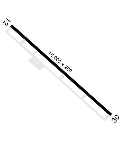
| Lat: N 3314.4 Long: W 11927.5 Elev: 506 Var: -12 Longest Runway: 10002 | ||
| Tower: 126.85 | ||
| ||||||||||||||||||||||||||||||||
| ||||||||||||||||||||||||||||||||
| Rwy | Rwy | |||||||
| 10002x200 | 9011' | 10002x200 | 10002' | 109.70 - 300° | ||||
| Runway ID | Single Wheel | Double Wheel | Double Tandem Wheel | Dual Double Wheel |
| 12/30 | N/A | N/A | N/A | N/A |
| These numbers are Advisory and are not limits. The Airport Manager should have more accurate Weight Limits | ||||
 Airport Diagram might not be current. | |
| Facility Name: | SAN NICOLAS ISLAND NOLF |
| City Name: | SAN NICOLAS ISLAND |
| County: | SANTA CRUZ |
| State abbrev: | CA |
| State Name: | CALIFORNIA |
| Ownership: | NAVY OWNED |
| Use: | PRIVATE |
| Owner's Name: | US NAVY |
| Address: | OCEANOGRAPHIC OFC - CODE 3142 |
| WASHINGTON, DC 20373 | |
| Owner's Phone: | |
| Manager's Name: | |
| Address: | |
| Phone: | |
| FAA Region: | WESTERN-PACIFIC |
| FAA Field Office: | LAX |
| Date | Sunrise | Sunset |
|---|---|---|
| 09/24/21 Friday | 6:47 | 18:52 |
| 09/25/21 Saturday | 6:48 | 18:51 |
| 09/26/21 Sunday | 6:49 | 18:49 |
| 09/27/21 Monday | 6:49 | 18:48 |
| 09/28/21 Tuesday | 6:50 | 18:47 |
| 09/29/21 Wednesday | 6:51 | 18:45 |
| 09/30/21 Thursday | 6:51 | 18:44 |
| 10/01/21 Friday | 6:52 | 18:42 |
| 10/02/21 Saturday | 6:53 | 18:41 |
| 10/03/21 Sunday | 6:53 | 18:40 |
| 10/04/21 Monday | 6:54 | 18:39 |
| 10/05/21 Tuesday | 6:55 | 18:37 |
| 10/06/21 Wednesday | 6:56 | 18:36 |
| 10/07/21 Thursday | 6:56 | 18:35 |
| Airport Attendance Schedule | |
| Airport Status | OPERATIONAL (This Status can change at any time - please check NOTAMS) |
| Airport Lighting Schedule | AVBL ONLY DURING HRS OF OPERATION. |
| Airport Storage Available | NONE |
| Extra Services Available | NONE |
| Wind Indicator | NONE |
| Control Tower | YES |
| CTAF Frequency | |
| Unicom Frequency | |
| Rotating Beacon Color | SPLIT-CLEAR-GREEN (LIGHTED MILITARY AIRPORT) |
| Segmented Circle | NO |
| Landing Fee |
| Airport Inspected | No Inspection Data Available performed by the OWNER |
| Inspection Date | Unknown |
| Type of Fuel Available | None |
| Airframe Repair Service | None |
| Power Plant Repair Service | None |
| Latitude | N3314.4 |
| Longitude | W11927.5 (ESTIMATED) |
| Arpt Elevation | 506ft (SURVEYED) |
| Magnetic Variation | 12E |
| 0 miles E | of SAN NICOLAS ISLAND |
| Traffic Pattern Altitude | |
| Sectional Chart | LOS ANGELES |
| Operations (Reported) | Yearly | Avg. Daily |
|---|---|---|
| General Aviation Transient | 0 | 0 |
| General Aviation Local | 0 | 0 |
| Air Taxi | 0 | 0 |
| Commerical | 0 | 0 |
| Commuter | 0 | 0 |
| Military | 0 | 0 |
| Aircraft based on Field | |
|---|---|
| General Aviation Singles | 0 |
| General Aviation Multi | 0 |
| Jet Aircraft | 0 |
| General Aviation Helicopters | 0 |
| Military Aircraft | 0 |
| Gliders | 0 |
| Ultralights | 0 |
| FSS on field | NO |
| FSS tie-in | HAWTHORNE |
| FSS Phone | 1-800-WX-BRIEF |
| Who issues Notams | NSI |
| Notam D service at airport | YES |
| ARTCC Name | LOS ANGELES |
| Airport Certification | |
| Aircraft Rescue & Firefighting Index | None |
| Airport of Entry | No |
| Custom Landing Rights | No |
| Joint Civil/Military | No |
| Military Landing rights | No |
| RSTD: OFFL BUS ONLY. 24 HR PPR FOR ALL ACFT OPR OT; 48 HR PPR FOR C-5 AND ACFT EXCEEDING PUBL LDG WT FR SAN NICOLAS ATC DSN 351-2253, C805-989-2253. |
| JASU: 1(GTC-85) 1(NC-10C) 1(NCPP-105) |
| TFC PAT: RGT TFC RWY 30. |
| CAUTION: POSSIBLE TURBULENCE SHORT FINAL RWY 30. |
| FUEL: J5 (MIL) |
| RSTD: RWY 12 TKOF AND LDG 9002'. |
| OPR 1500-2400Z++ MON-THU/ALTN FRI. CLSD ALTN FRI; ALL SAT, SUN AND HOL. |
| RSTD: POSSIBLE DIVERT ALL ACFT EXC EMERG TO PT MUGU NAWS DUE DRONE MISL OPR. |
| NS ABTMT: REMAIN AT LEAST 1 MILE OFFSHORE OR 1000' MSL. |
| MISC: CALL PLEAD CON 127.55 280.7 OR POINT MUGU APP 128.65 325.0 PRIOR TO ENTERING W289. |
| CTN UNLIT WIND TURBINES APRX 160 FT TALL, LCTD BTN 3,930 FT & 6,105 FT SOUTH OF THE RWY CNTRLN. |
| MISC: HGR SPACE MAINT NOT AVBL. |
Airport Communications & Frequencies:
| ||||||||||
| Runway: 12 | Runway: 30 | ||
| Mag heading: | N/A | Mag heading: | N/A |
| Rwy Slope: | .13% Up | Rwy Slope: | -.13% Down |
| Approach: | Approach: | LOC/GS | |
| Pattern: | Left Traffic | Pattern: | Right Traffic |
| Markings: | NONPRECISION INSTRUMENT | Markings: | NONPRECISION INSTRUMENT |
| Marking Condition: | FAIR | Marking Condition: | FAIR |
| Arresting Dev: | Arresting Dev: | ||
| Lat & Long: | N3314.9 W11928.2 | Lat. & Long.: | N3313.8 W11926.8 |
| Elev: | 484.6 ft. MSL | Elev: | 497.9 ft. MSL |
| TCH: | TCH: | 55 ft. AGL | |
| Visual Glide Path: | Visual Glide Path: | 3.00 degrees | |
| Displaced Threshold: | 991 feet | Displaced Threshold: | No |
| Touchdown Zone: | YES | Touchdown Zone: | YES |
| Touchdown Elev.: | 498.2 feet | Touchdown Elev.: | 506.2 feet |
| Visual Glide Slope: | Visual Glide Slope: | 4-Light PAPI on LEFT side of Runway | |
| RVR Equipment: | RVR Equipment: | ||
| RVV Equipment: | NO | RVV Equipment: | NO |
| Approach Lights: | Approach Lights: | ||
| REIL: | NO | REIL: | NO |
| Centerline Lights: | NO | Centerline Lights: | NO |
| Touchdown lights: | NO | Touchdown lights: | NO |
| Runway Category: | Runway Category: | ||
| Declared Distances: | LDA:9010' | Declared Distances: |
Thanks for using FltPlan.com
all rights reserved © 1999-2021 by Flight Plan LLC
