
| PORT ANGELES CGAS PORT ANGELES WA |
| |
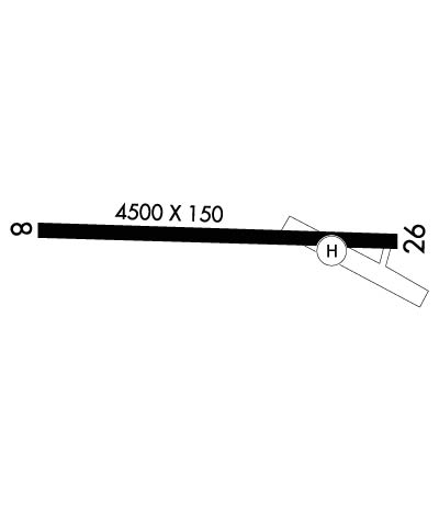
| Lat: N 4808.5 Long: W 12324.8 Elev: 13 Var: -17 Longest Runway: 4500 | ||
| Clr Del: 124.15 AWOS: 118.32 CTAF: 122.97 | ||
| ||||||
|
| Rwy | Rwy | |||||||
| 4500x150 | 4500' | 4500x150 | 4500' | |||||
| Runway ID | Single Wheel | Double Wheel | Double Tandem Wheel | Dual Double Wheel |
| 08/26 | N/A | N/A | N/A | N/A |
| H1 | N/A | N/A | N/A | N/A |
| These numbers are Advisory and are not limits. The Airport Manager should have more accurate Weight Limits | ||||
 Airport Diagram might not be current. | |
| Facility Name: | PORT ANGELES CGAS |
| City Name: | PORT ANGELES |
| County: | CLALLAM |
| State abbrev: | WA |
| State Name: | WASHINGTON |
| Ownership: | CG |
| Use: | PRIVATE |
| Owner's Name: | USCG |
| Address: | 1 EDIZ HOOK |
| PORT ANGELES, WA 98362 | |
| Owner's Phone: | |
| Manager's Name: | OPERATIONS OFFICER |
| Address: | 1 EDIZ HOOK |
| PORT ANGELES, WA 98362 | |
| Phone: | 360-417-5840 |
| FAA Region: | NORTHWEST MOUNTAIN |
| FAA Field Office: | SEA |
| Date | Sunrise | Sunset |
|---|---|---|
| 09/24/21 Friday | 7:03 | 19:08 |
| 09/25/21 Saturday | 7:04 | 19:05 |
| 09/26/21 Sunday | 7:06 | 19:03 |
| 09/27/21 Monday | 7:07 | 19:01 |
| 09/28/21 Tuesday | 7:08 | 18:59 |
| 09/29/21 Wednesday | 7:10 | 18:57 |
| 09/30/21 Thursday | 7:11 | 18:55 |
| 10/01/21 Friday | 7:13 | 18:53 |
| 10/02/21 Saturday | 7:14 | 18:51 |
| 10/03/21 Sunday | 7:16 | 18:49 |
| 10/04/21 Monday | 7:17 | 18:47 |
| 10/05/21 Tuesday | 7:18 | 18:45 |
| 10/06/21 Wednesday | 7:20 | 18:43 |
| 10/07/21 Thursday | 7:21 | 18:41 |
| Airport Attendance Schedule | CONTINUOUS |
| Airport Status | OPERATIONAL (This Status can change at any time - please check NOTAMS) |
| Airport Lighting Schedule | SS-SR |
| Airport Storage Available | NONE |
| Extra Services Available | NONE |
| Wind Indicator | YES - (lighted) |
| Control Tower | NO |
| CTAF Frequency | 122.975 |
| Unicom Frequency | 122.975 |
| Rotating Beacon Color | SPLIT-CLEAR-GREEN (LIGHTED MILITARY AIRPORT) |
| Segmented Circle | NO |
| Landing Fee |
| Airport Inspected | No Inspection Data Available performed by the OWNER |
| Inspection Date | Unknown |
| Type of Fuel Available | None |
| Airframe Repair Service | None |
| Power Plant Repair Service | None |
| Latitude | N4808.5 |
| Longitude | W12324.8 (ESTIMATED) |
| Arpt Elevation | 13ft (SURVEYED) |
| Magnetic Variation | 17E |
| 2 miles N | of PORT ANGELES |
| Traffic Pattern Altitude | |
| Sectional Chart | SEATTLE |
| Operations (Reported) | Yearly | Avg. Daily |
|---|---|---|
| General Aviation Transient | 0 | 0 |
| General Aviation Local | 0 | 0 |
| Air Taxi | 0 | 0 |
| Commerical | 0 | 0 |
| Commuter | 0 | 0 |
| Military | 0 | 0 |
| Aircraft based on Field | |
|---|---|
| General Aviation Singles | 0 |
| General Aviation Multi | 0 |
| Jet Aircraft | 0 |
| General Aviation Helicopters | 0 |
| Military Aircraft | 3 |
| Gliders | 0 |
| Ultralights | 0 |
| FSS on field | NO |
| FSS tie-in | SEATTLE |
| FSS Phone | 1-800-WX-BRIEF |
| Who issues Notams | SEA |
| Notam D service at airport | YES |
| ARTCC Name | SEATTLE |
| Airport Certification | |
| Aircraft Rescue & Firefighting Index | None |
| Airport of Entry | No |
| Custom Landing Rights | No |
| Joint Civil/Military | No |
| Military Landing rights | No |
| RSTD: CLSD TO NON-CG ACFT WO 24 HR PPR. C360-417-5840. |
| RSTD: 24 HR PPR FOR ALL TRANS ACFT. |
| TRAN ALERT: TRANS QTRS NOT AVBL. |
| FOR CD CTC WHIDBEY APCH AT 360-257-3310. |
| CTC PORT ANGELES AIR ON 345.0 OR 127.7, 15 MIN PRIOR TO LNDG. |
| FUEL: J8 AVBL TO SAR AND CG MSN ONLY. |
| BIRDS ON RY ALL YR. BLDGS AS CLOSE AS 126 FT FR RY CNTRLN. |
Airport Communications & Frequencies:
| |||||||||||||||||||
| Runway: 08 | Runway: 26 | ||
| Mag heading: | 76° | Mag heading: | 256° |
| Rwy Slope: | -.02% Down | Rwy Slope: | .02% Up |
| Approach: | Approach: | ||
| Pattern: | Left Traffic | Pattern: | Left Traffic |
| Markings: | Markings: | ||
| Marking Condition: | Marking Condition: | ||
| Arresting Dev: | Arresting Dev: | ||
| Lat & Long: | N4808.5 W12325.4 | Lat. & Long.: | N4808.5 W12324.3 |
| Elev: | 9.0 ft. MSL | Elev: | 8.0 ft. MSL |
| TCH: | TCH: | ||
| Visual Glide Path: | Visual Glide Path: | ||
| Displaced Threshold: | No | Displaced Threshold: | No |
| Touchdown Zone: | YES | Touchdown Zone: | YES |
| Touchdown Elev.: | 9.0 feet | Touchdown Elev.: | 9.0 feet |
| Visual Glide Slope: | Visual Glide Slope: | ||
| RVR Equipment: | RVR Equipment: | ||
| RVV Equipment: | NO | RVV Equipment: | NO |
| Approach Lights: | Approach Lights: | ||
| REIL: | NO | REIL: | NO |
| Centerline Lights: | NO | Centerline Lights: | NO |
| Touchdown lights: | NO | Touchdown lights: | NO |
| Runway Category: | Runway with a Visual Approach | Runway Category: | Runway with a Visual Approach |
| Declared Distances: | Declared Distances: |
Thanks for using FltPlan.com
all rights reserved © 1999-2021 by Flight Plan LLC
