
| MERIDIAN NAS/MC CAIN FIELD MERIDIAN MS |
| |
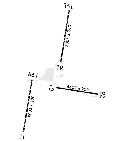
| Lat: N 3233.2 Long: W 08833.3 Elev: 316 Var: +02 Longest Runway: 8003 | ||
| Clr Del: 301.0 Dept. ATIS: 290.52 Arr. ATIS: 290.52 Tower: 126.2 | ||
| ||||||
|
| Rwy | Rwy | |||||||
| 8003x200 | 8003' | 8003x200 | 8003' | |||||
| 8000x200 | 8000' | 8000x200 | 8000' | 109.70 - 190° | ||||
| 6402x200 | 6402' | 6402x200 | 6402' | |||||
| Runway ID | Single Wheel | Double Wheel | Double Tandem Wheel | Dual Double Wheel |
| 01L/19R | N/A | N/A | N/A | N/A |
| 01R/19L | N/A | N/A | N/A | N/A |
| 10/28 | N/A | N/A | N/A | N/A |
| These numbers are Advisory and are not limits. The Airport Manager should have more accurate Weight Limits | ||||
 Airport Diagram might not be current. | |
| Facility Name: | MERIDIAN NAS (MC CAIN FLD) |
| City Name: | MERIDIAN |
| County: | LAUDERDALE |
| State abbrev: | MS |
| State Name: | MISSISSIPPI |
| Ownership: | NAVY OWNED |
| Use: | PRIVATE |
| Owner's Name: | US NAVY |
| Address: | OCEANOGRAPHIC OFC-CODE 3142 |
| WASHINGTON, DC 20373 | |
| Owner's Phone: | |
| Manager's Name: | COMMANDING OFFICER |
| Address: | NAVAL AIR STATION |
| MERIDIAN, MS 39301 | |
| Phone: | 601 6792470/2505; OPNS DUTY OFF (ODO) ON AUTOVON 446-2470. |
| FAA Region: | SOUTHERN |
| FAA Field Office: | JAN |
| Date | Sunrise | Sunset |
|---|---|---|
| 06/07/26 Sunday | 5:46 | 20:00 |
| 06/08/26 Monday | 5:46 | 20:00 |
| 06/09/26 Tuesday | 5:46 | 20:01 |
| 06/10/26 Wednesday | 5:46 | 20:01 |
| 06/11/26 Thursday | 5:46 | 20:02 |
| 06/12/26 Friday | 5:46 | 20:02 |
| 06/13/26 Saturday | 5:46 | 20:02 |
| 06/14/26 Sunday | 5:46 | 20:03 |
| 06/15/26 Monday | 5:46 | 20:03 |
| 06/16/26 Tuesday | 5:46 | 20:03 |
| 06/17/26 Wednesday | 5:46 | 20:04 |
| 06/18/26 Thursday | 5:47 | 20:04 |
| 06/19/26 Friday | 5:47 | 20:04 |
| 06/20/26 Saturday | 5:47 | 20:05 |
| Airport Attendance Schedule | FRI 1200-2200Z++, MON-THUR 1300-0400++; CLSD SAT, SUN AND HOL EXC BY NOTAM. |
| Airport Status | OPERATIONAL (This Status can change at any time - please check NOTAMS) |
| Airport Lighting Schedule | AVBL ONLY DURING HRS OF OPERATION. |
| Airport Storage Available | NONE |
| Extra Services Available | NONE |
| Wind Indicator | NONE |
| Control Tower | YES |
| CTAF Frequency | |
| Unicom Frequency | |
| Rotating Beacon Color | SWG |
| Segmented Circle | NO |
| Landing Fee |
| Airport Inspected | No Inspection Data Available performed by the OWNER |
| Inspection Date | Unknown |
| Type of Fuel Available | Grade 100LLA++J8; -10SVC AVBL DURING AIRFIELD HRS OF OPS. EXPECT 1 HR REFUEL DELAYS. |
| Airframe Repair Service | None |
| Power Plant Repair Service | None |
| Latitude | N3233.2 |
| Longitude | W08833.3 (ESTIMATED) |
| Arpt Elevation | 315ft (SURVEYED) |
| Magnetic Variation | 02W |
| 11 miles NE | of MERIDIAN |
| Traffic Pattern Altitude | 900 |
| Sectional Chart | MEMPHIS |
| Operations (Reported) | Yearly | Avg. Daily |
|---|---|---|
| General Aviation Transient | 0 | 0 |
| General Aviation Local | 0 | 0 |
| Air Taxi | 0 | 0 |
| Commerical | 0 | 0 |
| Commuter | 0 | 0 |
| Military | 0 | 0 |
| Aircraft based on Field | |
|---|---|
| General Aviation Singles | 0 |
| General Aviation Multi | 0 |
| Jet Aircraft | 0 |
| General Aviation Helicopters | 0 |
| Military Aircraft | 0 |
| Gliders | 0 |
| Ultralights | 0 |
| FSS on field | NO |
| FSS tie-in | GREENWOOD |
| FSS Phone | 1-800-WX-BRIEF |
| Who issues Notams | NMM |
| Notam D service at airport | YES |
| ARTCC Name | MEMPHIS |
| Airport Certification | |
| Aircraft Rescue & Firefighting Index | None |
| Airport of Entry | No |
| Custom Landing Rights | No |
| Joint Civil/Military | No |
| Military Landing rights | No |
| LGT: PORTABLE OLS AVBL RWY 01L, 01R, 19L, 19R AND 28. |
| JASU: 2(NC-8A) (GTC-85) 1(NCPP-105) |
| TRAN ALERT: SVC AVBL 1300-0500Z++ MON-THU, 1300-2300Z++ FRI. DRAG CHUTE REPACK UNAVBL. |
| RSTD: ALL ACFT RQR PPR, CTC BASE OPS DSN 637-2470/2505, C601-679-2470/2505. PPR GOOD FOR +/- 1 HR PPR TIME. FOR CALP PROCESSING CTC AFM VIA BASE OPS. |
| CAUTION: RWY 19L & 19R HAVE 1 PERCENT DOWN GRAD FIRST 6000 FT.WILDLIFE IN VCNTY ALL RWY. MAT AND TWY S OF HGR NOT VIS FR TWR. INTS STU JET TRNG DUR FLD OPR HR. |
| TFC PAT: BRK ALT 1400 FT MSL. TRAN ACFT EXPC VISUAL APCH. VFR ACFT CTC MERIDIAN APP WITHIN 25 NM. |
| MISC: RAMP ELEV 283 FT. EXP ARR/DEP DLY EXTSV STU TRNG. NO CLASSIFIED MATERIALS AVBL. |
| BASE OPS 1300-0500Z MON-THUR; 1300-2300Z FRI, CLSD SAT, SUN & HOLS EXCP BY NOTAM. . |
| SCHEDULING POINT: 187 FW, AL ANG. LOCATION: MONTGOMERY, AL. DSN: 358-9255 C334-394-7255. |
| TRANS ALERT: LTD AIRSTART CAPABILITIES FOR TRAN ACFT. CTC 601-679-2342 TO VERIFY STATUS PRIOR TO REQ PPR. |
| SERVICE: A-GEAR NORMALLY RIGGED ON ALL RWYS. |
| FOR CD WHEN UNA VIA FREQ CTC MERIDIAN APCH 601-679-3691, WHEN MERIDIAN APCH CLSD CTC MEMPHIS ARTCC AT 901-368-8453/8449. |
Airport Communications & Frequencies:
| |||||||||||||||||||||||||||||||||||||||||||
| Runway: 01L | Runway: 19R | ||
| Mag heading: | 11° | Mag heading: | 191° |
| Rwy Slope: | .50% Up | Rwy Slope: | -.50% Down |
| Approach: | Approach: | ||
| Pattern: | Left Traffic | Pattern: | Left Traffic |
| Markings: | Markings: | ||
| Marking Condition: | FAIR | Marking Condition: | FAIR |
| Arresting Dev: | E28; HOOK E28(B) (1750') | Arresting Dev: | E28; HOOK E28(B) (1251') |
| Lat & Long: | N3231.8 W08834.3 | Lat. & Long.: | N3233.1 W08834.0 |
| Elev: | 253.5 ft. MSL | Elev: | 293.8 ft. MSL |
| TCH: | TCH: | 40 ft. AGL | |
| Visual Glide Path: | Visual Glide Path: | 3.00 degrees | |
| Displaced Threshold: | No | Displaced Threshold: | No |
| Touchdown Zone: | YES | Touchdown Zone: | YES |
| Touchdown Elev.: | 253.4 feet | Touchdown Elev.: | 293.8 feet |
| Visual Glide Slope: | NONSTANDARD VASI SYSTEM; OPTICAL LANDING SYSTEM & WAVE-OFF. | Visual Glide Slope: | 4-Light PAPI on RIGHT side of Runway |
| RVR Equipment: | RVR Equipment: | ||
| RVV Equipment: | NO | RVV Equipment: | NO |
| Approach Lights: | ALSF1 - standard 2,400 foot high intensity approach lighting system with sequenced flashers, Category I | Approach Lights: | |
| REIL: | NO | REIL: | NO |
| Centerline Lights: | YES | Centerline Lights: | YES |
| Touchdown lights: | NO | Touchdown lights: | NO |
| Runway Category: | Runway Category: | ||
| Declared Distances: | Declared Distances: |
| Runway: 01R | Runway: 19L | ||
| Mag heading: | 11° | Mag heading: | 191° |
| Rwy Slope: | .58% Up | Rwy Slope: | -.58% Down |
| Approach: | Approach: | ILS/DME | |
| Pattern: | Left Traffic | Pattern: | Left Traffic |
| Markings: | Markings: | ||
| Marking Condition: | FAIR | Marking Condition: | FAIR |
| Arresting Dev: | E28; HOOK E28(B) (1250') | Arresting Dev: | E28; HOOK E28(B) (1748') |
| Lat & Long: | N3233.6 W08833.1 | Lat. & Long.: | N3234.9 W08832.9 |
| Elev: | 269.7 ft. MSL | Elev: | 315.7 ft. MSL |
| TCH: | TCH: | ||
| Visual Glide Path: | Visual Glide Path: | ||
| Displaced Threshold: | No | Displaced Threshold: | No |
| Touchdown Zone: | YES | Touchdown Zone: | YES |
| Touchdown Elev.: | 269.7 feet | Touchdown Elev.: | 315.7 feet |
| Visual Glide Slope: | OPTICAL LANDING SYSTEM. | Visual Glide Slope: | NONSTANDARD VASI SYSTEM; OPTICAL LANDING SYSTEM & WAVE-OFF. |
| RVR Equipment: | ROLLOUT | RVR Equipment: | TOUCHDOWN |
| RVV Equipment: | NO | RVV Equipment: | NO |
| Approach Lights: | Approach Lights: | MALSR - 1,400 foot medium intensity approach lighting system with runway alignment indicator lights | |
| REIL: | NO | REIL: | NO |
| Centerline Lights: | YES | Centerline Lights: | YES |
| Touchdown lights: | NO | Touchdown lights: | NO |
| Runway Category: | Runway Category: | ||
| Declared Distances: | Declared Distances: |
| Runway: 10 | Runway: 28 | ||
| Mag heading: | 101° | Mag heading: | 281° |
| Rwy Slope: | .07% Up | Rwy Slope: | -.07% Down |
| Approach: | Approach: | ||
| Pattern: | Left Traffic | Pattern: | Left Traffic |
| Markings: | Markings: | ||
| Marking Condition: | Marking Condition: | ||
| Arresting Dev: | E28; HOOK E28(B) (1250') | Arresting Dev: | E28; HOOK E28(B) (1250') |
| Lat & Long: | N3232.9 W08833.3 | Lat. & Long.: | N3232.8 W08832.0 |
| Elev: | 299.2 ft. MSL | Elev: | 303.6 ft. MSL |
| TCH: | TCH: | ||
| Visual Glide Path: | Visual Glide Path: | ||
| Displaced Threshold: | No | Displaced Threshold: | No |
| Touchdown Zone: | YES | Touchdown Zone: | YES |
| Touchdown Elev.: | 304.0 feet | Touchdown Elev.: | 304.5 feet |
| Visual Glide Slope: | Visual Glide Slope: | ||
| RVR Equipment: | RVR Equipment: | ||
| RVV Equipment: | NO | RVV Equipment: | NO |
| Approach Lights: | Approach Lights: | ||
| REIL: | NO | REIL: | NO |
| Centerline Lights: | NO | Centerline Lights: | NO |
| Touchdown lights: | NO | Touchdown lights: | NO |
| Runway Category: | Runway Category: | ||
| Declared Distances: | Declared Distances: |
Thanks for using FltPlan.com
all rights reserved © 1999-2026 by Flight Plan LLC
