
| CHERRY POINT MCAS /CUNNINGHAM CHERRY POINT NC |
| |
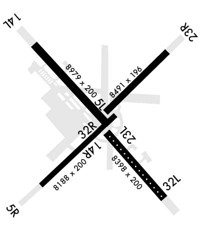
| Lat: N 3454.2 Long: W 07652.8 Elev: 29 Var: +09 Longest Runway: 8979 | ||
| Clr Del: 125.95 Dept. ATIS: 127.47 Arr. ATIS: 127.47 Ground: 128.62 Tower: 121.3 | ||
| ||||||
|
| Rwy | Rwy | |||||||
| 8491x196 | 7552' | 8491x196 | 8491' | 108.90 - 234° | ||||
| 8188x200 | 8188' | 8188x200 | 8188' | |||||
| 8979x200 | 8979' | 8979x200 | 8979' | |||||
| 8398x200 | 7551' | 8398x200 | 8398' | |||||
| Runway ID | Single Wheel | Double Wheel | Double Tandem Wheel | Dual Double Wheel |
| 05L/23R | N/A | N/A | N/A | N/A |
| 05R/23L | N/A | N/A | N/A | N/A |
| 14L/32R | N/A | N/A | N/A | N/A |
| 14R/32L | N/A | N/A | N/A | N/A |
| These numbers are Advisory and are not limits. The Airport Manager should have more accurate Weight Limits | ||||
 Airport Diagram might not be current. | |
| Facility Name: | CHERRY POINT MCAS /CUNNINGHAM FLD/ |
| City Name: | CHERRY POINT |
| County: | PAMLICO |
| State abbrev: | NC |
| State Name: | NORTH CAROLINA |
| Ownership: | NAVY OWNED |
| Use: | PRIVATE |
| Owner's Name: | US NAVY |
| Address: | OCEANOGRAPHIC OFC-CODE 3142 |
| WASHINGTON, DC 20373 | |
| Owner's Phone: | |
| Manager's Name: | COMMANDING OFFICER |
| Address: | MARINE CORPS AIR STATION |
| CHERRY POINT, NC 28533 | |
| Phone: | 252-466-2233 |
| FAA Region: | SOUTHERN |
| FAA Field Office: | MEM |
| Date | Sunrise | Sunset |
|---|---|---|
| 09/24/21 Friday | 6:57 | 19:02 |
| 09/25/21 Saturday | 6:58 | 19:00 |
| 09/26/21 Sunday | 6:58 | 18:59 |
| 09/27/21 Monday | 6:59 | 18:58 |
| 09/28/21 Tuesday | 7:00 | 18:56 |
| 09/29/21 Wednesday | 7:01 | 18:55 |
| 09/30/21 Thursday | 7:01 | 18:53 |
| 10/01/21 Friday | 7:02 | 18:52 |
| 10/02/21 Saturday | 7:03 | 18:50 |
| 10/03/21 Sunday | 7:04 | 18:49 |
| 10/04/21 Monday | 7:04 | 18:48 |
| 10/05/21 Tuesday | 7:05 | 18:46 |
| 10/06/21 Wednesday | 7:06 | 18:45 |
| 10/07/21 Thursday | 7:07 | 18:44 |
| Airport Attendance Schedule | CONTINUOUS |
| Airport Status | OPERATIONAL (This Status can change at any time - please check NOTAMS) |
| Airport Lighting Schedule | AVBL ONLY DURING HRS OF OPERATION. |
| Airport Storage Available | NONE |
| Extra Services Available | NONE |
| Wind Indicator | NONE |
| Control Tower | YES |
| CTAF Frequency | |
| Unicom Frequency | |
| Rotating Beacon Color | SPLIT-CLEAR-GREEN (LIGHTED MILITARY AIRPORT) |
| Segmented Circle | NO |
| Landing Fee |
| Airport Inspected | No Inspection Data Available performed by the OWNER |
| Inspection Date | Unknown |
| Type of Fuel Available | Grade 100LLJ5; -10FUEL: HOT PIT REFUL AVBL. |
| Airframe Repair Service | None |
| Power Plant Repair Service | None |
| Latitude | N3454.2 |
| Longitude | W07652.8 (ESTIMATED) |
| Arpt Elevation | 29ft (ESTIMATED) |
| Magnetic Variation | 09W |
| 2 miles NE | of CHERRY POINT |
| Traffic Pattern Altitude | TPA: 1000 FT AGL, OVHD PAT ALT 1500 FT AGL. |
| Sectional Chart | CHARLOTTE |
| Operations (Reported) | Yearly | Avg. Daily |
|---|---|---|
| General Aviation Transient | 0 | 0 |
| General Aviation Local | 0 | 0 |
| Air Taxi | 0 | 0 |
| Commerical | 0 | 0 |
| Commuter | 0 | 0 |
| Military | 0 | 0 |
| Aircraft based on Field | |
|---|---|
| General Aviation Singles | 0 |
| General Aviation Multi | 0 |
| Jet Aircraft | 0 |
| General Aviation Helicopters | 0 |
| Military Aircraft | 0 |
| Gliders | 0 |
| Ultralights | 0 |
| FSS on field | NO |
| FSS tie-in | CHERRY POINT MCAS |
| FSS Phone | 1-800-WX-BRIEF |
| Who issues Notams | NKT |
| Notam D service at airport | YES |
| ARTCC Name | WASHINGTON |
| Airport Certification | |
| Aircraft Rescue & Firefighting Index | None |
| Airport of Entry | No |
| Custom Landing Rights | No |
| Joint Civil/Military | No |
| Military Landing rights | No |
| PPR WKENDS CTC OPNS DUTY OFFICER; V582-3632/5025. |
| LGT: PORTABLE LGT-MOBILE FLOOD LGT. |
| A-GEAR: ALL E-28(B) IN RAISED POSN EXC ON LDG RWY. RQR 15 MIN PN. |
| JASU: 2 WORKING DAYS PN RQR. 2(GTC-85) 1(NCPP-105) |
| FLUID: SP PRESAIR HPOX LOX DE-ICE |
| TRAN ALERT: LTD TRAN MAINT AVBL 1200-2100Z++ MON-FRI. NO LAVATORY SVC AVBL. |
| SEE FLIP AP/1 SUPPLEMENTARY ARPT |
| RSTD: MIN 24HR NOTICE PPR ALL TRAN ACFT. CALL BASE OPS DSN 582-2233/4334, C252-466-2233/4334. FLT PLANNING/BASE OPS OPR 24 HR EXCEPT FEDERAL HOLIDAYS, EXP CLOSURE OR REDUCED SVCS PER NOTAM. ALL RWY AND TWY, EXC TWY A AND C, WILL SUPPORT ALL ACFT AT ALL WT. |
| CAUTION: EXTV STU JET TRNG (V/STOL) VCNTY ARPT. TRAN ACFT EXP STR-IN FULL STOP LDG ONLY DUR PEAK STU TRNG PERIODS. BIRD HAZ OCT-APR. DRAINAGE DITCHES PARL ALL RWY. WILDLIFE HAZ ON ARPT, ESPECIALLY SS-SR. OBST APRX 200' NEAR NKT R-205/3. |
| TFC PAT: LDG/TAXI LGT RQR ALL LDG. REDUCED RWY SEPARATION IN EFF FOR USN/USMC ACFT. |
| CSTMS/AG/IMG: CSTMS, AG AVBL WITH 24 HR PN. REF FCG FOR DETAILS. ACFT ARRV. FROM OVERSEAS CTC OPS VIA FONE PATCH 252-466-2233 MIN 2 HR PRIOR TO ARR FOR CSTMS. |
| MISC: 24 HR PN RQR OF ALL DV CODES, CTC BASE OPS DSN 582-2233, C252-466-2233. ALL ACFT WITH PAX/CARGO/DV MUST CTC PTD 20 MIN PRIOR TO LDG. ATC TERMINOLOGY - CENTERMAT - IS DEFINED AS THE CNTR OF AFLD WHERE THE FOUR TWYS INT, RATED FOR ALL ACFT WHEEL WEIGHTS. |
| TSNT ALERT: PPR MIN 24 HRS IN ADV. TRAN ACFT WITH INERT ORDNANCE, HOT PIT REFUEL LTD TO F18, USAF F15, F16, AND A10 ACFT ONLY IAW CHERRY POINT AIROPS MAN. |
| CAUTION: OBSTACLE UNLIT TWR AT NKT200006 549 FT. |
| ACFT RESTRICTED FM TAXIING ON TWY 'K' BTN RY 23R & TEST CELL. TOWING OPERATIONS ONLY. |
| MIN 24 HR NTC IF ANTI-ICING/DE-ICING SVC RQR, CTC TRAN ACFT DSN 582-3232, C252-466-3232. |
| RWY 05L/23R HAS A Y AMP-3 ALZ PAINTED ON RWY. RWY 14R/32L HAS W AMP-3 ALZ PAINTED ON RWY |
| ALL ACFT ENROUTE TO CHERRY POINT MCAS RQRG SERVICING CONTACT BASE OPS WITH REQUEST. |
| AIRCRAFT STRUCTURAL DE-ICING AVAILABLE. |
Airport Communications & Frequencies:
| |||||||||||||||||||||||||||||||||||||||||||||||||||||||||||||||
| Runway: 05L | Runway: 23R | ||
| Mag heading: | 54° | Mag heading: | 234° |
| Rwy Slope: | -.07% Down | Rwy Slope: | .07% Up |
| Approach: | Approach: | ILS/DME | |
| Pattern: | Left Traffic | Pattern: | Left Traffic |
| Markings: | Markings: | ||
| Marking Condition: | Marking Condition: | ||
| Arresting Dev: | Arresting Dev: | E28; HOOK E28(B) (2438'). | |
| Lat & Long: | N3454.1 W07653.0 | Lat. & Long.: | N3455.1 W07651.8 |
| Elev: | 24.3 ft. MSL | Elev: | 18.7 ft. MSL |
| TCH: | TCH: | 74 ft. AGL | |
| Visual Glide Path: | Visual Glide Path: | 3.00 degrees | |
| Displaced Threshold: | 939 feet | Displaced Threshold: | No |
| Touchdown Zone: | YES | Touchdown Zone: | YES |
| Touchdown Elev.: | 28.4 feet | Touchdown Elev.: | 23.0 feet |
| Visual Glide Slope: | Visual Glide Slope: | 4-Light PAPI on LEFT side of Runway | |
| RVR Equipment: | RVR Equipment: | ||
| RVV Equipment: | NO | RVV Equipment: | NO |
| Approach Lights: | Approach Lights: | MALSF - 1,400 foot medium intensity approach lighting system with sequenced flashers | |
| REIL: | NO | REIL: | NO |
| Centerline Lights: | NO | Centerline Lights: | NO |
| Touchdown lights: | NO | Touchdown lights: | NO |
| Runway Category: | Runway Category: | ||
| Declared Distances: | TORA:8491' TODA:8491' ASDA:8491' LDA:8491' | Declared Distances: | TORA:7553' TODA:8491' ASDA:8491' LDA:7552' |
| Runway: 05R | Runway: 23L | ||
| Mag heading: | N/A | Mag heading: | N/A |
| Rwy Slope: | .04% Up | Rwy Slope: | -.04% Down |
| Approach: | Approach: | ||
| Pattern: | Left Traffic | Pattern: | Left Traffic |
| Markings: | Markings: | ||
| Marking Condition: | Marking Condition: | ||
| Arresting Dev: | E28; HOOK E28(B) (1500') | Arresting Dev: | |
| Lat & Long: | N3453.3 W07653.9 | Lat. & Long.: | N3454.2 W07652.7 |
| Elev: | 22.8 ft. MSL | Elev: | 26.1 ft. MSL |
| TCH: | 73 ft. AGL | TCH: | |
| Visual Glide Path: | 3.00 degrees | Visual Glide Path: | |
| Displaced Threshold: | No | Displaced Threshold: | No |
| Touchdown Zone: | YES | Touchdown Zone: | YES |
| Touchdown Elev.: | 26.6 feet | Touchdown Elev.: | 28.8 feet |
| Visual Glide Slope: | 4-Light PAPI on LEFT side of Runway | Visual Glide Slope: | |
| RVR Equipment: | RVR Equipment: | ||
| RVV Equipment: | NO | RVV Equipment: | NO |
| Approach Lights: | Approach Lights: | ||
| REIL: | NO | REIL: | NO |
| Centerline Lights: | NO | Centerline Lights: | NO |
| Touchdown lights: | NO | Touchdown lights: | NO |
| Runway Category: | Runway Category: | ||
| Declared Distances: | Declared Distances: |
| Runway: 14L | Runway: 32R | ||
| Mag heading: | N/A | Mag heading: | N/A |
| Rwy Slope: | .09% Up | Rwy Slope: | -.09% Down |
| Approach: | Approach: | ||
| Pattern: | Left Traffic | Pattern: | Left Traffic |
| Markings: | Markings: | ||
| Marking Condition: | Marking Condition: | ||
| Arresting Dev: | E28,E5; HOOK E28(B) (1500') | Arresting Dev: | |
| Lat & Long: | N3455.2 W07654.0 | Lat. & Long.: | N3454.1 W07652.7 |
| Elev: | 19.4 ft. MSL | Elev: | 27.3 ft. MSL |
| TCH: | 72 ft. AGL | TCH: | |
| Visual Glide Path: | 3.00 degrees | Visual Glide Path: | |
| Displaced Threshold: | No | Displaced Threshold: | No |
| Touchdown Zone: | YES | Touchdown Zone: | YES |
| Touchdown Elev.: | 25.8 feet | Touchdown Elev.: | 28.7 feet |
| Visual Glide Slope: | 4-Light PAPI on LEFT side of Runway | Visual Glide Slope: | |
| RVR Equipment: | RVR Equipment: | ||
| RVV Equipment: | NO | RVV Equipment: | NO |
| Approach Lights: | Approach Lights: | ||
| REIL: | NO | REIL: | NO |
| Centerline Lights: | NO | Centerline Lights: | NO |
| Touchdown lights: | NO | Touchdown lights: | NO |
| Runway Category: | Runway Category: | ||
| Declared Distances: | Declared Distances: |
| Runway: 14R | Runway: 32L | ||
| Mag heading: | 145° | Mag heading: | 325° |
| Rwy Slope: | -.10% Down | Rwy Slope: | .10% Up |
| Approach: | Approach: | ||
| Pattern: | Left Traffic | Pattern: | Left Traffic |
| Markings: | Markings: | ||
| Marking Condition: | Marking Condition: | ||
| Arresting Dev: | Arresting Dev: | E28; HOOK E28(B) (1500') | |
| Lat & Long: | N3454.2 W07652.9 | Lat. & Long.: | N3453.2 W07651.8 |
| Elev: | 24.9 ft. MSL | Elev: | 16.9 ft. MSL |
| TCH: | TCH: | 78 ft. AGL | |
| Visual Glide Path: | Visual Glide Path: | 3.00 degrees | |
| Displaced Threshold: | 847 feet | Displaced Threshold: | No |
| Touchdown Zone: | YES | Touchdown Zone: | YES |
| Touchdown Elev.: | 29.3 feet | Touchdown Elev.: | 25.6 feet |
| Visual Glide Slope: | Visual Glide Slope: | 4-Light PAPI on LEFT side of Runway | |
| RVR Equipment: | RVR Equipment: | ||
| RVV Equipment: | NO | RVV Equipment: | NO |
| Approach Lights: | Approach Lights: | ALSF1 - standard 2,400 foot high intensity approach lighting system with sequenced flashers, Category I | |
| REIL: | NO | REIL: | NO |
| Centerline Lights: | YES | Centerline Lights: | YES |
| Touchdown lights: | NO | Touchdown lights: | NO |
| Runway Category: | Runway Category: | ||
| Declared Distances: | TORA:8398' TODA:8399' ASDA:8399' LDA:7553' | Declared Distances: | TORA:8398' TODA:8399' ASDA:8399' LDA:7553' |
Thanks for using FltPlan.com
all rights reserved © 1999-2021 by Flight Plan LLC
