
| CHINA LAKE NAWS/ARMITAGE FIELD CHINA LAKE CA |
| |
| Lat: N 3541.1 Long: W 11741.7 Elev: 2288 Var: -14 Longest Runway: 11199 | ||
| Clr Del: 274.7 Dept. ATIS: 322.37 Arr. ATIS: 322.37 Ground: 360.2 Tower: 120.15 | ||
| ||||||||||||||||||||||||||||||||
| ||||||||||||||||||||||||||||||||
| Rwy | Rwy | |||||||
| 10000x200 | 10000' | 10000x200 | 10000' | |||||
| 11199x200 | 11199' | 11199x200 | 11199' | |||||
| 9014x200 | 9014' | 9014x200 | 9014' | |||||
| Runway ID | Single Wheel | Double Wheel | Double Tandem Wheel | Dual Double Wheel |
| 03/21 | N/A | N/A | N/A | N/A |
| 08/26 | N/A | N/A | N/A | N/A |
| 14/32 | N/A | N/A | N/A | N/A |
| These numbers are Advisory and are not limits. The Airport Manager should have more accurate Weight Limits | ||||
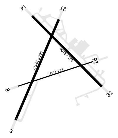 Airport Diagram might not be current. | |
| Facility Name: | CHINA LAKE NAWS (ARMITAGE FLD) |
| City Name: | CHINA LAKE |
| County: | KERN |
| State abbrev: | CA |
| State Name: | CALIFORNIA |
| Ownership: | NAVY OWNED |
| Use: | PRIVATE |
| Owner's Name: | US NAVY |
| Address: | OCEANOGRAPHIC OFC - CODE 3142 |
| WASHINGTON, DC 20373 | |
| Owner's Phone: | |
| Manager's Name: | COMMANDING OFFICER |
| Address: | NAVAL AIR FACILITY |
| CHINA LAKE, CA 93555 | |
| Phone: | |
| FAA Region: | WESTERN-PACIFIC |
| FAA Field Office: | LAX |
| Date | Sunrise | Sunset |
|---|---|---|
| 06/07/26 Sunday | 5:35 | 20:05 |
| 06/08/26 Monday | 5:35 | 20:05 |
| 06/09/26 Tuesday | 5:34 | 20:06 |
| 06/10/26 Wednesday | 5:34 | 20:06 |
| 06/11/26 Thursday | 5:34 | 20:07 |
| 06/12/26 Friday | 5:34 | 20:07 |
| 06/13/26 Saturday | 5:34 | 20:07 |
| 06/14/26 Sunday | 5:34 | 20:08 |
| 06/15/26 Monday | 5:34 | 20:08 |
| 06/16/26 Tuesday | 5:34 | 20:09 |
| 06/17/26 Wednesday | 5:35 | 20:09 |
| 06/18/26 Thursday | 5:35 | 20:09 |
| 06/19/26 Friday | 5:35 | 20:09 |
| 06/20/26 Saturday | 5:35 | 20:10 |
| Airport Attendance Schedule | MON-FRI 1530-0630Z++, SUN 2300-0100Z++; CLSD ALTN FRI. OPEN 1530-2030Z++, CLSD 2030-2300Z++, OPEN 2330-0100Z++ 1ST WORKING/NON-HOL FRI OF THE MONTH. SAT-SUN OPR BY PPR/LCL USE ONLY. SEE FLIP AP/1 SUPPLEMENTARY ARPT INFO. |
| Airport Status | OPERATIONAL (This Status can change at any time - please check NOTAMS) |
| Airport Lighting Schedule | AVBL ONLY DURING HRS OF OPERATION. |
| Airport Storage Available | NONE |
| Extra Services Available | NONE |
| Wind Indicator | NONE |
| Control Tower | YES |
| CTAF Frequency | |
| Unicom Frequency | |
| Rotating Beacon Color | SWG |
| Segmented Circle | NO |
| Landing Fee |
| Airport Inspected | No Inspection Data Available performed by the OWNER |
| Inspection Date | Unknown |
| Type of Fuel Available | None |
| Airframe Repair Service | NONE |
| Power Plant Repair Service | NONE |
| Latitude | N3541.1 |
| Longitude | W11741.7 (ESTIMATED) |
| Arpt Elevation | 2288ft (ESTIMATED) |
| Magnetic Variation | 14E |
| 3 miles NW | of CHINA LAKE |
| Traffic Pattern Altitude | TFC PAT - REDUCED RWY SEPARATION STD IN EFF USN/USMC ACFT. NS ABTMT - DEP AVOID OVFT CHINA LAKE AND CITY OF RIDGECREST 2 NM SSE. |
| Sectional Chart | LOS ANGELES |
| Operations (Reported) | Yearly | Avg. Daily |
|---|---|---|
| General Aviation Transient | 0 | 0 |
| General Aviation Local | 0 | 0 |
| Air Taxi | 0 | 0 |
| Commerical | 0 | 0 |
| Commuter | 0 | 0 |
| Military | 0 | 0 |
| Aircraft based on Field | |
|---|---|
| General Aviation Singles | 0 |
| General Aviation Multi | 0 |
| Jet Aircraft | 0 |
| General Aviation Helicopters | 0 |
| Military Aircraft | 0 |
| Gliders | 0 |
| Ultralights | 0 |
| FSS on field | NO |
| FSS tie-in | RIVERSIDE |
| FSS Phone | 1-800-WX-BRIEF |
| Who issues Notams | NID |
| Notam D service at airport | YES |
| ARTCC Name | LOS ANGELES |
| Airport Certification | |
| Aircraft Rescue & Firefighting Index | None |
| Airport of Entry | No |
| Custom Landing Rights | No |
| Joint Civil/Military | No |
| Military Landing rights | No |
| TRAN ALERT - EXP SVC DELAY. LTD TRAN SVC AVBL 1530-0300Z++ MON-FRI. |
| RSTD - PPR DSN 437-5301. ALL PPR ISSUED 1530-0630Z++ WEEKDAYS ONLY. |
| CSTMS/AG/IMG - CSTMS NOT AVBL. ACFT ENTERING FR FOREIGN COUNTRIES MUST CLEAR CSTMS PRIOR ARR. |
| MISC - TRAN ACFT TO/FR CHINA LAKE NID MUST CTC R2508 COMPLEX CONTROL BOARD FOR SKED/BRIEF PRIOR TO OBTAINING A PPR. PORTIONS OF APCH END RWY 26 AND ADJ TWY NOT VISIBLE FR TWR. |
| MISC: LTD PAX SVC AVBL. |
| SERVICE LGT: RWY 03/21, RWY 08/26 AND 14/32 MRKD AND LGTD 200 FT WIDE. |
| RSTD: PPR CIVIL ACFT OFFL BUS. FOR CALP REQS CTC AIRFIELD MGR 760-939-5032 OR TRML 760-939-5301. RSTD AFLD HRS SUBJ CHG. PILOTS FILING KNID CHINA LAKE AS AN ALTN OR EMERG DIV ARE ADZD TO CALL BASE OPS DSN 437-5475 TO VFY OPERG HRS. |
| CAUTION - BIRD HAZ NEAR GOLF CRS, WI CLASS D AIRSPACE, OCT-APR. |
| CAUTION: TWY B AND TWY G NOT LGTD. |
| CAUTION: TWY C CLSD. |
| JASU - 3(GTC-85), 5(NC-10A1), 1(NC-10B), 1(NC-10C), 7(AM32A-108), 4(A/M47A-4), 4(MSU-200). |
| FUEL - F24- AVBL 1400-0700Z++ MON-THU; 1400-0430Z++ ALT THU-FRI; 2200-0700Z++ SUN |
| OIL - O-133-156. |
Airport Communications & Frequencies:
| |||||||||||||||||||||||||||||||||||||
| Runway: 03 | Runway: 21 | ||
| Mag heading: | 28° | Mag heading: | 208° |
| Rwy Slope: | -.83% Down | Rwy Slope: | .83% Up |
| Approach: | Approach: | ||
| Pattern: | Left Traffic | Pattern: | Left Traffic |
| Markings: | NONPRECISION INSTRUMENT | Markings: | NONPRECISION INSTRUMENT |
| Marking Condition: | GOOD | Marking Condition: | GOOD |
| Arresting Dev: | E28; HOOK E28(B) (1657 FT). | Arresting Dev: | E28; HOOK E28(B) (2793 FT). |
| Lat & Long: | N3540.5; HORIZONTAL DATUM WGS84. W11742.5 | Lat. & Long.: | N3541.8; HORIZONTAL DATUM WGS84. W11741.1 |
| Elev: | 2284.0 ft. MSL | Elev: | 2201.0 ft. MSL |
| TCH: | TCH: | 57 ft. AGL | |
| Visual Glide Path: | Visual Glide Path: | 3.00 degrees | |
| Displaced Threshold: | No | Displaced Threshold: | No |
| Touchdown Zone: | YES | Touchdown Zone: | YES |
| Touchdown Elev.: | 2284.0 feet | Touchdown Elev.: | 2227.9 feet |
| Visual Glide Slope: | Visual Glide Slope: | 4-Light PAPI on LEFT side of Runway | |
| RVR Equipment: | RVR Equipment: | ||
| RVV Equipment: | NO | RVV Equipment: | NO |
| Approach Lights: | Approach Lights: | OLS | |
| REIL: | NO | REIL: | NO |
| Centerline Lights: | NO | Centerline Lights: | NO |
| Touchdown lights: | NO | Touchdown lights: | NO |
| Runway Category: | Runway Category: | ||
| Declared Distances: | Declared Distances: |
| Runway: 08 | Runway: 26 | ||
| Mag heading: | 76° | Mag heading: | 256° |
| Rwy Slope: | -.50% Down | Rwy Slope: | .50% Up |
| Approach: | Approach: | ||
| Pattern: | Left Traffic | Pattern: | Left Traffic |
| Markings: | NONPRECISION INSTRUMENT | Markings: | NONPRECISION INSTRUMENT |
| Marking Condition: | GOOD | Marking Condition: | GOOD |
| Arresting Dev: | E28; HOOK E28(B) (1765 FT). | Arresting Dev: | E28; HOOK E28(B) (1545 FT). |
| Lat & Long: | N3541.0; HORIZONTAL DATUM WGS84. W11743.2 | Lat. & Long.: | N3541.0; HORIZONTAL DATUM WGS84. W11740.9 |
| Elev: | 2288.2 ft. MSL | Elev: | 2232.2 ft. MSL |
| TCH: | 45 ft. AGL | TCH: | 46 ft. AGL |
| Visual Glide Path: | 3.00 degrees | Visual Glide Path: | 3.00 degrees |
| Displaced Threshold: | No | Displaced Threshold: | No |
| Touchdown Zone: | YES | Touchdown Zone: | YES |
| Touchdown Elev.: | 2288.2 feet | Touchdown Elev.: | 2230.6 feet |
| Visual Glide Slope: | 4-Light PAPI on LEFT side of Runway | Visual Glide Slope: | 4-Light PAPI on LEFT side of Runway |
| RVR Equipment: | RVR Equipment: | ||
| RVV Equipment: | NO | RVV Equipment: | NO |
| Approach Lights: | Approach Lights: | ||
| REIL: | NO | REIL: | NO |
| Centerline Lights: | NO | Centerline Lights: | NO |
| Touchdown lights: | NO | Touchdown lights: | NO |
| Runway Category: | Runway Category: | ||
| Declared Distances: | Declared Distances: |
| Runway: 14 | Runway: 32 | ||
| Mag heading: | 140° | Mag heading: | 320° |
| Rwy Slope: | .42% Up | Rwy Slope: | -.42% Down |
| Approach: | Approach: | ||
| Pattern: | Left Traffic | Pattern: | Left Traffic |
| Markings: | NONPRECISION INSTRUMENT | Markings: | NONPRECISION INSTRUMENT |
| Marking Condition: | GOOD | Marking Condition: | GOOD |
| Arresting Dev: | Arresting Dev: | ||
| Lat & Long: | N3541.9; HORIZONTAL DATUM WGS84. W11741.6 | Lat. & Long.: | N3540.6; HORIZONTAL DATUM WGS84. W11740.8 |
| Elev: | 2203.2 ft. MSL | Elev: | 2240.9 ft. MSL |
| TCH: | 52 ft. AGL | TCH: | 50 ft. AGL |
| Visual Glide Path: | 3.00 degrees | Visual Glide Path: | 3.00 degrees |
| Displaced Threshold: | No | Displaced Threshold: | No |
| Touchdown Zone: | YES | Touchdown Zone: | YES |
| Touchdown Elev.: | 2215.8 feet | Touchdown Elev.: | 2240.9 feet |
| Visual Glide Slope: | 4-Light PAPI on RIGHT side of Runway | Visual Glide Slope: | 4-Light PAPI on RIGHT side of Runway |
| RVR Equipment: | RVR Equipment: | ||
| RVV Equipment: | NO | RVV Equipment: | NO |
| Approach Lights: | OLS | Approach Lights: | OLS |
| REIL: | NO | REIL: | NO |
| Centerline Lights: | NO | Centerline Lights: | NO |
| Touchdown lights: | NO | Touchdown lights: | NO |
| Runway Category: | Runway Category: | ||
| Declared Distances: | Declared Distances: |
Thanks for using FltPlan.com
all rights reserved © 1999-2026 by Flight Plan LLC
