
| PATUXENT RIVER NAS (TRAPNELL F PATUXENT RIVER MD |
| |
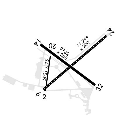
| Lat: N 3817.2 Long: W 07624.6 Elev: 39 Var: +10 Longest Runway: 11799 | ||
| Clr Del: 135.2 Dept. ATIS: 322.42 Arr. ATIS: 322.42 Ground: 120.6 Tower: 123.7 | ||
| ||||||
|
| Rwy | Rwy | |||||||
| 5021x75 | 5021' | 5021x75 | 5021' | |||||
| 11799x200 | 11799' | 108.70 - 059° | 11799x200 | 11799' | ||||
| 9732x200 | 9732' | 9732x200 | 9732' | |||||
| Runway ID | Single Wheel | Double Wheel | Double Tandem Wheel | Dual Double Wheel |
| 02/20 | N/A | N/A | N/A | N/A |
| 06/24 | N/A | N/A | N/A | N/A |
| 14/32 | N/A | N/A | N/A | N/A |
| These numbers are Advisory and are not limits. The Airport Manager should have more accurate Weight Limits | ||||
 Airport Diagram might not be current. | |
| Facility Name: | PATUXENT RIVER NAS (TRAPNELL FLD) |
| City Name: | PATUXENT RIVER |
| County: | ST MARYS |
| State abbrev: | MD |
| State Name: | MARYLAND |
| Ownership: | NAVY OWNED |
| Use: | PRIVATE |
| Owner's Name: | US NAVY |
| Address: | OCEANOGRAPHIC OFC-CODE 3142 |
| WASHINGTON, DC 20373 | |
| Owner's Phone: | |
| Manager's Name: | COMMANDING OFFICER |
| Address: | NAVAL AIR STATION |
| PATUXENT RIVER, MD 20670-5409 | |
| Phone: | 301-863-3339 |
| FAA Region: | EASTERN |
| FAA Field Office: | DCA |
| Date | Sunrise | Sunset |
|---|---|---|
| 06/07/26 Sunday | 5:42 | 20:27 |
| 06/08/26 Monday | 5:42 | 20:27 |
| 06/09/26 Tuesday | 5:42 | 20:28 |
| 06/10/26 Wednesday | 5:42 | 20:28 |
| 06/11/26 Thursday | 5:42 | 20:29 |
| 06/12/26 Friday | 5:42 | 20:29 |
| 06/13/26 Saturday | 5:42 | 20:30 |
| 06/14/26 Sunday | 5:42 | 20:30 |
| 06/15/26 Monday | 5:42 | 20:31 |
| 06/16/26 Tuesday | 5:42 | 20:31 |
| 06/17/26 Wednesday | 5:42 | 20:31 |
| 06/18/26 Thursday | 5:42 | 20:32 |
| 06/19/26 Friday | 5:42 | 20:32 |
| 06/20/26 Saturday | 5:42 | 20:32 |
| Airport Attendance Schedule | 7 Days A Week 1200-0400Z++.; CLSD HOLIDAYS. |
| Airport Status | OPERATIONAL (This Status can change at any time - please check NOTAMS) |
| Airport Lighting Schedule | AVBL ONLY DURING HRS OF OPERATION. |
| Airport Storage Available | NONE |
| Extra Services Available | NONE |
| Wind Indicator | NONE |
| Control Tower | YES |
| CTAF Frequency | |
| Unicom Frequency | |
| Rotating Beacon Color | SWG |
| Segmented Circle | NO |
| Landing Fee |
| Airport Inspected | No Inspection Data Available performed by the OWNER |
| Inspection Date | Unknown |
| Type of Fuel Available | None |
| Airframe Repair Service | None |
| Power Plant Repair Service | None |
| Latitude | N3817.2 |
| Longitude | W07624.6 (ESTIMATED) |
| Arpt Elevation | 38ft (SURVEYED) |
| Magnetic Variation | 10W |
| 0 miles N | of PATUXENT RIVER |
| Traffic Pattern Altitude | |
| Sectional Chart | WASHINGTON |
| Operations (Reported) | Yearly | Avg. Daily |
|---|---|---|
| General Aviation Transient | 0 | 0 |
| General Aviation Local | 0 | 0 |
| Air Taxi | 0 | 0 |
| Commerical | 0 | 0 |
| Commuter | 0 | 0 |
| Military | 0 | 0 |
| Aircraft based on Field | |
|---|---|
| General Aviation Singles | 0 |
| General Aviation Multi | 0 |
| Jet Aircraft | 0 |
| General Aviation Helicopters | 0 |
| Military Aircraft | 0 |
| Gliders | 0 |
| Ultralights | 0 |
| FSS on field | NO |
| FSS tie-in | LEESBURG |
| FSS Phone | 1-800-WX-BRIEF |
| Who issues Notams | DCA |
| Notam D service at airport | YES |
| ARTCC Name | WASHINGTON |
| Airport Certification | |
| Aircraft Rescue & Firefighting Index | None |
| Airport of Entry | No |
| Custom Landing Rights | YES |
| Joint Civil/Military | No |
| Military Landing rights | No |
| JASU: (GTC-85) (NCPP-105) (NC-8) (NC-10). |
| NS ABTMT: MIL ACFT MAINT AT LEAST 1500 FT BTN 3 NM AND 10 NM FR 210 DEG CW TO 240 DEG. NO PRACTICE APCH 0300Z++ TO 1200Z++ MON-FRI, SAT BEFORE 1500Z++, SUN BEFORE 1700Z++. TRAN ACFT PRACTICE APCH NOT TO INTERFERE BASIS. |
| CSTMS/AG/IMG: LTD TO ACFT ON OFFICIAL BUSINESS AT PAX RIV WITH 72 HR PN. CTC AODO AT DSN 342-3836, C301-342-3836. |
| MISC: WX FCST SVC AVBL 0900-0100Z++ MON-FRI. FOR FCST SVC ALL OT CTC FWC-N AT DSN 565-4555 OR C888-745-6899. WX OBSN AND PMSV MTR AVBL 1100-0400Z++ MON-FRI AND 1200-2300Z++ SAT-SUN. |
| FOR CD WHEN NHK ATCT/APCH ARE CLSD CTC POTOMAC APCH AT 866-640-4124. |
| MISC: FOR INFO REGARDING CIVIL AIR LANDING PERMITS (CALPS) CTC AFM AT 301-342-8923 OR EMAIL NASPATUXENTRIVERCALPS@US.NAVY.MIL. |
| SERVICE: NO BASE TRANSPORTATION AVBL. |
| MISC: NS NORFOLK, CHAMBERS FLD COORD ALL FLT PLANNING SVC. FLT PLANS SHOULD BE EMAILED TO W_CNI_NRFK_NSNORFOLK_N32_ATC_USERS@NAVY.MIL OR FAX TO DSN 565-9680, C757-445-9680. TO CONFIRM RECEIPT OF FLT PLANS CALL NS NORFOLK, CHAMBERS FLD FLT PLANNING SUPERVISOR AT DSN 232-3419/3429, C757-322-3419/3429. |
| MISC: CLASS D AVAIL EXCLUDING THAT AIRSPACE WITHIN RESTRICTED AREAS R-4005 AND R-4007 WHEN ACTIVE. SEE FLIP AP/1 SUPPLEMENTARY ARPT REMARKS. |
| FUEL: 100LL, A, J5. |
| FLUID: SP LHOX LOX. |
| OIL: O-128-133-148-156 (MIL). |
| TRAN ALERT: AVBL 1200-23000Z++ MON-FRI EXC HOL. |
| REMARKS: OPR 1200-0400Z++ MON-FRI,1300-2300Z++ SAT-SUN, CLSD HOL. SEE FLIP AP/1 SUPPLEMENTARY ARPT |
| RSTD: PPR-NO NOTAM TRML FAC AVBL. PPR REQUESTS SHOULD BE EMAILED TO PAXPPRS@US.NAVY.MIL TO CONFIRM RECEIPT OF PPRS CALL DSN 342-8923, C301-342-8923. ACFT MUST MAKE PRIOR ARNG AND RCV PPR FR HOST SQUADRON, OR NAS AIR OPERATONS. LTD RAMP SPACE, AND LTD TRAN SVC AVBL EXPECT DELAYS. TWY ALL EXP DLY DUE TO ACFT WT LIMITATIONS. |
| CAUTION: STOPPING IN RSTD AREA ON TWY A, W TWY IS PROH. PORTIONS OF RWY, TWY AND ACFT RAMPS NOT VIS FR TWR. FIRST 1630 FT. RWY 32 MAY BE CLSD DALGT HR MON-SAT DUR VFR. BUILDINGS AND EQUIPMENT ARE LOCATED NEAR THE APPROACH END OF RWY 32. DEER AND BIRD HAZ. |
| TFC PAT: VFR INITIAL AT 4 DME (RWY 32 AT 3 DME) 2000 FT, BREAK 1500 FT, DOWNWIND 1000 FT. REDUCED RWY SEPARATION STD IN EFF FOR LCL BASED USN/USMC ACFT. |
Airport Communications & Frequencies:
| |||||||||||||||||||||||||||||||||||||||||||||||||||||||||
| Runway: 02 | Runway: 20 | ||
| Mag heading: | 18° | Mag heading: | 198° |
| Rwy Slope: | -.25% Down | Rwy Slope: | .25% Up |
| Approach: | Approach: | ||
| Pattern: | Left Traffic | Pattern: | Left Traffic |
| Markings: | NONPRECISION INSTRUMENT | Markings: | NONPRECISION INSTRUMENT |
| Marking Condition: | GOOD | Marking Condition: | GOOD |
| Arresting Dev: | Arresting Dev: | ||
| Lat & Long: | N3816.6 W07625.3 | Lat. & Long.: | N3817.4 W07625.1 |
| Elev: | 37.2 ft. MSL | Elev: | 24.6 ft. MSL |
| TCH: | TCH: | ||
| Visual Glide Path: | Visual Glide Path: | ||
| Displaced Threshold: | No | Displaced Threshold: | No |
| Touchdown Zone: | YES | Touchdown Zone: | YES |
| Touchdown Elev.: | 37.2 feet | Touchdown Elev.: | 32.9 feet |
| Visual Glide Slope: | Visual Glide Slope: | ||
| RVR Equipment: | RVR Equipment: | ||
| RVV Equipment: | NO | RVV Equipment: | NO |
| Approach Lights: | Approach Lights: | ||
| REIL: | NO | REIL: | NO |
| Centerline Lights: | NO | Centerline Lights: | NO |
| Touchdown lights: | NO | Touchdown lights: | NO |
| Runway Category: | Runway Category: | ||
| Declared Distances: | Declared Distances: |
| Runway: 06 | Runway: 24 | ||
| Mag heading: | 59° | Mag heading: | 239° |
| Rwy Slope: | -.16% Down | Rwy Slope: | .16% Up |
| Approach: | ILS/DME | Approach: | |
| Pattern: | Left Traffic | Pattern: | Left Traffic |
| Markings: | PRECISION INSTRUMENT | Markings: | PRECISION INSTRUMENT |
| Marking Condition: | GOOD | Marking Condition: | GOOD |
| Arresting Dev: | E28; HOOK E28(B) (2180 FT). | Arresting Dev: | E28; HOOK E28(B) (1499 FT). |
| Lat & Long: | N3816.6 W07625.3 | Lat. & Long.: | N3817.9 W07623.4 |
| Elev: | 38.6 ft. MSL | Elev: | 19.6 ft. MSL |
| TCH: | TCH: | ||
| Visual Glide Path: | Visual Glide Path: | ||
| Displaced Threshold: | No | Displaced Threshold: | No |
| Touchdown Zone: | YES | Touchdown Zone: | YES |
| Touchdown Elev.: | 38.6 feet | Touchdown Elev.: | 19.8 feet |
| Visual Glide Slope: | Visual Glide Slope: | ||
| RVR Equipment: | RVR Equipment: | ||
| RVV Equipment: | NO | RVV Equipment: | NO |
| Approach Lights: | ALSF1 - standard 2,400 foot high intensity approach lighting system with sequenced flashers, Category I; OLS. | Approach Lights: | OLS. |
| REIL: | NO | REIL: | NO |
| Centerline Lights: | YES | Centerline Lights: | YES |
| Touchdown lights: | YES | Touchdown lights: | NO |
| Runway Category: | Runway Category: | ||
| Declared Distances: | Declared Distances: |
| Runway: 14 | Runway: 32 | ||
| Mag heading: | 136° | Mag heading: | 316° |
| Rwy Slope: | -.12% Down | Rwy Slope: | .12% Up |
| Approach: | Approach: | ||
| Pattern: | Left Traffic | Pattern: | Left Traffic |
| Markings: | PRECISION INSTRUMENT | Markings: | PRECISION INSTRUMENT |
| Marking Condition: | GOOD | Marking Condition: | GOOD |
| Arresting Dev: | E28; HOOK E28(B) (1280 FT). | Arresting Dev: | E28; HOOK E28(B) (3050 FT). |
| Lat & Long: | N3817.7 W07625.4 | Lat. & Long.: | N3816.7 W07623.8 |
| Elev: | 26.9 ft. MSL | Elev: | 15.6 ft. MSL |
| TCH: | TCH: | ||
| Visual Glide Path: | Visual Glide Path: | ||
| Displaced Threshold: | No | Displaced Threshold: | No |
| Touchdown Zone: | YES | Touchdown Zone: | YES |
| Touchdown Elev.: | 26.9 feet | Touchdown Elev.: | 18.1 feet |
| Visual Glide Slope: | Visual Glide Slope: | ||
| RVR Equipment: | RVR Equipment: | ||
| RVV Equipment: | NO | RVV Equipment: | NO |
| Approach Lights: | OLS. | Approach Lights: | OLS. |
| REIL: | NO | REIL: | NO |
| Centerline Lights: | NO | Centerline Lights: | NO |
| Touchdown lights: | NO | Touchdown lights: | NO |
| Runway Category: | Runway Category: | ||
| Declared Distances: | Declared Distances: |
Thanks for using FltPlan.com
all rights reserved © 1999-2026 by Flight Plan LLC
