
| FALLON NAS /VAN VOORHIS FLD/ FALLON NV |
| |
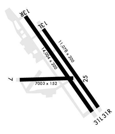
| Lat: N 3925.1 Long: W 11841.9 Elev: 3935 Var: -14 Longest Runway: 14001 | ||
| Tower: 119.25 | ||
| ||||||||||||||||||||||||||||||||
| ||||||||||||||||||||||||||||||||
| Rwy | Rwy | |||||||
| 7003x152 | 7003' | 7003x152 | 7003' | |||||
| 11076x200 | 11076' | 11076x200 | 11076' | |||||
| 14001x201 | 14001' | 14001x201 | 14001' | |||||
| Runway ID | Single Wheel | Double Wheel | Double Tandem Wheel | Dual Double Wheel |
| 07/25 | N/A | N/A | N/A | N/A |
| 13L/31R | N/A | N/A | N/A | N/A |
| 13R/31L | N/A | N/A | N/A | N/A |
| These numbers are Advisory and are not limits. The Airport Manager should have more accurate Weight Limits | ||||
 Airport Diagram might not be current. | |
| Facility Name: | FALLON NAS (VAN VOORHIS FLD) |
| City Name: | FALLON |
| County: | CHURCHILL |
| State abbrev: | NV |
| State Name: | NEVADA |
| Ownership: | NAVY OWNED |
| Use: | PRIVATE |
| Owner's Name: | US NAVY; ROWDY YATES 775-426-2427. |
| Address: | OCEANOGRAPHIC OFC - CODE 3142 |
| WASHINGTON, DC 20373 | |
| Owner's Phone: | |
| Manager's Name: | COMMANDING OFFICER |
| Address: | NAVAL AIR STATION |
| FALLON, NV 89406 | |
| Phone: | 775-426-2419; RATCF - 775-426-2590. |
| FAA Region: | WESTERN-PACIFIC |
| FAA Field Office: | PHX |
| Date | Sunrise | Sunset |
|---|---|---|
| 06/07/26 Sunday | 5:28 | 20:20 |
| 06/08/26 Monday | 5:28 | 20:20 |
| 06/09/26 Tuesday | 5:28 | 20:21 |
| 06/10/26 Wednesday | 5:27 | 20:21 |
| 06/11/26 Thursday | 5:27 | 20:22 |
| 06/12/26 Friday | 5:27 | 20:22 |
| 06/13/26 Saturday | 5:27 | 20:23 |
| 06/14/26 Sunday | 5:27 | 20:23 |
| 06/15/26 Monday | 5:27 | 20:23 |
| 06/16/26 Tuesday | 5:27 | 20:24 |
| 06/17/26 Wednesday | 5:27 | 20:24 |
| 06/18/26 Thursday | 5:27 | 20:24 |
| 06/19/26 Friday | 5:28 | 20:25 |
| 06/20/26 Saturday | 5:28 | 20:25 |
| Airport Attendance Schedule | MON-FRI 1530-0700Z, SAT 1800-0200Z++, SUN 2000-0200Z++; CLSD HOL; OTR TIMES BY NOTAM. |
| Airport Status | OPERATIONAL (This Status can change at any time - please check NOTAMS) |
| Airport Lighting Schedule | AVBL DURG OPS HRS. |
| Airport Storage Available | NONE |
| Extra Services Available | NONE |
| Wind Indicator | NONE |
| Control Tower | YES |
| CTAF Frequency | |
| Unicom Frequency | |
| Rotating Beacon Color | SWG |
| Segmented Circle | NO |
| Landing Fee |
| Airport Inspected | No Inspection Data Available performed by the OWNER |
| Inspection Date | Unknown |
| Type of Fuel Available | None |
| Airframe Repair Service | None |
| Power Plant Repair Service | None |
| Latitude | N3925.1 |
| Longitude | W11841.9 (ESTIMATED) |
| Arpt Elevation | 3934ft (SURVEYED) |
| Magnetic Variation | 14E |
| 3 miles NE | of FALLON |
| Traffic Pattern Altitude | INITIAL ALL RWY 7600 FT; OVERHEAD BREAK 5500 FT; NO OVERHEAD FOR RWY 07; PAT ALT 5000 FT. |
| Sectional Chart | SAN FRANCISCO |
| Operations (Reported) | Yearly | Avg. Daily |
|---|---|---|
| General Aviation Transient | 0 | 0 |
| General Aviation Local | 0 | 0 |
| Air Taxi | 0 | 0 |
| Commerical | 0 | 0 |
| Commuter | 0 | 0 |
| Military | 0 | 0 |
| Aircraft based on Field | |
|---|---|
| General Aviation Singles | 0 |
| General Aviation Multi | 0 |
| Jet Aircraft | 0 |
| General Aviation Helicopters | 0 |
| Military Aircraft | 0 |
| Gliders | 0 |
| Ultralights | 0 |
| FSS on field | NO |
| FSS tie-in | RENO |
| FSS Phone | 1-800-WX-BRIEF |
| Who issues Notams | NFL |
| Notam D service at airport | YES |
| ARTCC Name | OAKLAND |
| Airport Certification | |
| Aircraft Rescue & Firefighting Index | None |
| Airport of Entry | No |
| Custom Landing Rights | No |
| Joint Civil/Military | No |
| Military Landing rights | No |
| AGREEMENT UNDER DLAND OR DCLA HAS EXPIRED. |
| A-GEAR: E-28(B) APCH END ON PARALLEL RWYS NML DERIGGED. |
| TFC PAT: ACTVT LDG/TAXI LGT ON APCH. RDC RWY SEPN STD IN EFCT FOR USN/USMCFT. |
| MISC: NASF ODO DSN 890-2419/2458/C775-426-2419/2458. |
| MISC: PPR TO SKED FRTC AIRSPACE AFT AIRFIELD HRS - NAS FALLON OPS OFFICER APVL EXTD AIRFIELD HRS. |
| FUEL: A++; 4 HR PN RQR FOR ACFT REQ HOT REFUEL, REQ INVLD AFTER 30 MIN, DSN 890-3461/3481 C775-426-2508/9. |
| CTN: 126 FT RADAR DOME 1.1 NM SW OF ATCT. TWY C, S APN TO RWY 25 APCH END VRBL WID TAPERING TO 50 FT E OF RWY 13R-31L. |
| NOISE ABATEMENT: DEP RWY 31L/R VFR TURN RIGHT HDG 040 OVER DEP END. DESELECT AFTERBURNER AT EOR & CLB AS QUICKLY AS PSBL. |
| CTN: HVY MIL TRNG OPS ALL HRS. |
| MISC: RWY 13L/31R TGL OVR 100000 LB NA. |
| MISC: CLASS D AIRSPACE REVERTS TO CLASS E WHEN TWR CLSD; WHEN TWR OPEN, CLASS E AIRSPACE REVERTS TO CLASS D. |
| JASU: 1(GTC-85) 1(NCPP-105) 2(NC-8A). |
| RSTD: ALL CIV ACFT MUST HAVE CURRENT CALP AND MEET ALL RQRMTS. CALP POC IS NASF ODO LCTD IN BLDG 301 AT C775-426-2419. |
| DEPLOYING SQDNS/CVW CTC SCHEDULER DSN 890-2545 C775-426-2545. |
| FLUID: SP LOX. |
| TRAN ALERT: NO TSNT MAINT/HGR SPACE OR DE-ICE AVBL. |
| SEE FLIP AP/1 SUPPLEMENTARY ARPT |
| RSTD: PPR 24 HR IN ADVN FOR TSNT SVC EXC MEDEVAC, SAR, SKED L FLT. PPR VALID 4 HR BYD ETA UNLESS RESKED - DSN 890-3549, C775-426-3549. |
| CTN: BIRD ACT WI 15 NM SFC - 3000 FT. GA OPS FM FALLON MUNI 5 NM NNW. |
| RWY 13R/ 31LLRG MULTI ENG; FSL/TGL RWY 31; LND PAST BI-DRCTNL (E28) ARRESTING GEAR 1892 FT FM AER. |
| RWY 13R/ 31LALSO ST154. |
Airport Communications & Frequencies:
| |||||||||||||||||||||||
| Runway: 07 | Runway: 25 | ||
| Mag heading: | 74° | Mag heading: | 254° |
| Rwy Slope: | -.03% Down | Rwy Slope: | .03% Up |
| Approach: | Approach: | ||
| Pattern: | Left Traffic | Pattern: | Left Traffic |
| Markings: | PRECISION INSTRUMENT | Markings: | BASIC |
| Marking Condition: | GOOD | Marking Condition: | GOOD |
| Arresting Dev: | E28; HOOK E28(B) (1300 FT). | Arresting Dev: | E28; HOOK E28(B) (1290 FT). |
| Lat & Long: | N3924.8 W11843.0 | Lat. & Long.: | N3924.8 W11841.5 |
| Elev: | 3929.0 ft. MSL | Elev: | 3926.7 ft. MSL |
| TCH: | TCH: | ||
| Visual Glide Path: | Visual Glide Path: | ||
| Displaced Threshold: | No | Displaced Threshold: | No |
| Touchdown Zone: | YES | Touchdown Zone: | YES |
| Touchdown Elev.: | 3930.5 feet | Touchdown Elev.: | 3927.7 feet |
| Visual Glide Slope: | Visual Glide Slope: | ||
| RVR Equipment: | RVR Equipment: | ||
| RVV Equipment: | NO | RVV Equipment: | NO |
| Approach Lights: | Approach Lights: | ||
| REIL: | NO | REIL: | NO |
| Centerline Lights: | NO | Centerline Lights: | NO |
| Touchdown lights: | NO | Touchdown lights: | NO |
| Runway Category: | Runway Category: | ||
| Declared Distances: | Declared Distances: |
| Runway: 13L | Runway: 31R | ||
| Mag heading: | 131° | Mag heading: | 311° |
| Rwy Slope: | -.07% Down | Rwy Slope: | .07% Up |
| Approach: | Approach: | ||
| Pattern: | Left Traffic | Pattern: | Left Traffic |
| Markings: | PRECISION INSTRUMENT | Markings: | PRECISION INSTRUMENT |
| Marking Condition: | GOOD | Marking Condition: | GOOD |
| Arresting Dev: | E28; HOOK E28(B) (952 FT). | Arresting Dev: | E28; HOOK E28(B) (951 FT). |
| Lat & Long: | N3925.8 W11842.3 | Lat. & Long.: | N3924.3 W11841.0 |
| Elev: | 3934.7 ft. MSL | Elev: | 3926.7 ft. MSL |
| TCH: | 48 ft. AGL | TCH: | 56 ft. AGL |
| Visual Glide Path: | 3.00 degrees | Visual Glide Path: | 3.50 degrees |
| Displaced Threshold: | No | Displaced Threshold: | No |
| Touchdown Zone: | YES | Touchdown Zone: | YES |
| Touchdown Elev.: | 3934.8 feet | Touchdown Elev.: | 3928.1 feet |
| Visual Glide Slope: | 4-Light PAPI on RIGHT side of Runway | Visual Glide Slope: | 4-Light PAPI on LEFT side of Runway |
| RVR Equipment: | RVR Equipment: | ||
| RVV Equipment: | NO | RVV Equipment: | NO |
| Approach Lights: | Approach Lights: | ||
| REIL: | NO | REIL: | NO |
| Centerline Lights: | NO | Centerline Lights: | NO |
| Touchdown lights: | NO | Touchdown lights: | NO |
| Runway Category: | Runway Category: | ||
| Declared Distances: | Declared Distances: |
| Runway: 13R | Runway: 31L | ||
| Mag heading: | 131° | Mag heading: | 311° |
| Rwy Slope: | -.06% Down | Rwy Slope: | .06% Up |
| Approach: | Approach: | ||
| Pattern: | Left Traffic | Pattern: | Left Traffic |
| Markings: | PRECISION INSTRUMENT | Markings: | PRECISION INSTRUMENT |
| Marking Condition: | GOOD | Marking Condition: | GOOD |
| Arresting Dev: | E28; HOOK E28(B) (1804 FT). | Arresting Dev: | E28; HOOK E28(B) (1893 FT). |
| Lat & Long: | N3926.1 W11842.8 | Lat. & Long.: | N3924.2 W11841.1 |
| Elev: | 3934.8 ft. MSL | Elev: | 3926.8 ft. MSL |
| TCH: | 52 ft. AGL | TCH: | 61 ft. AGL |
| Visual Glide Path: | 3.00 degrees | Visual Glide Path: | 3.50 degrees |
| Displaced Threshold: | No | Displaced Threshold: | No |
| Touchdown Zone: | YES | Touchdown Zone: | YES |
| Touchdown Elev.: | 3935.0 feet | Touchdown Elev.: | 3926.9 feet |
| Visual Glide Slope: | 4-Light PAPI on LEFT side of Runway; PAPI 13R UNUSBL BYD 5 DEG EACH SIDE OF CNTRLN. | Visual Glide Slope: | 4-Light PAPI on LEFT side of Runway; PAPI 31L UNUSBL BYD 5 DEG EACH SIDE OF CNTRLN. |
| RVR Equipment: | RVR Equipment: | ||
| RVV Equipment: | NO | RVV Equipment: | NO |
| Approach Lights: | Approach Lights: | ||
| REIL: | NO | REIL: | NO |
| Centerline Lights: | NO | Centerline Lights: | NO |
| Touchdown lights: | NO | Touchdown lights: | NO |
| Runway Category: | Runway Category: | ||
| Declared Distances: | Declared Distances: |
Thanks for using FltPlan.com
all rights reserved © 1999-2026 by Flight Plan LLC
