
| NEW RIVER MCAS JACKSONVILLE NC |
| |
| Lat: N 3442.5 Long: W 07726.4 Elev: 26 Var: +08 Longest Runway: 5126 | ||
| Clr Del: 269.25 Dept. ATIS: 288.32 Arr. ATIS: 288.32 Ground: 121.8 Tower: 120.0 | ||
| ||
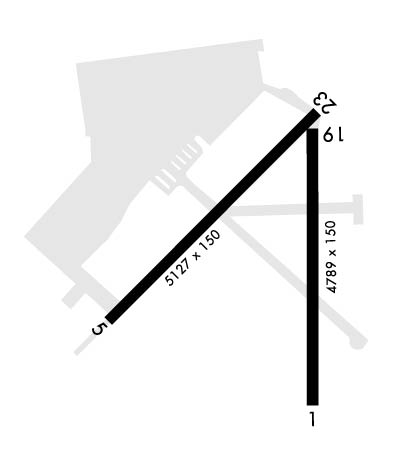
| Rwy | Rwy | |||||||
| 4789x150 | 4789' | 111.10 - 007° | 4789x150 | 4789' | ||||
| 5126x150 | 5126' | 5126x150 | 5126' | |||||
| Runway ID | Single Wheel | Double Wheel | Double Tandem Wheel | Dual Double Wheel |
| 01/19 | N/A | N/A | N/A | N/A |
| 05/23 | N/A | N/A | N/A | N/A |
| These numbers are Advisory and are not limits. The Airport Manager should have more accurate Weight Limits | ||||
 Airport Diagram might not be current. | |
| Facility Name: | NEW RIVER MCAS /H/ MCCUTCHEON FLD |
| City Name: | JACKSONVILLE |
| County: | ONSLOW |
| State abbrev: | NC |
| State Name: | NORTH CAROLINA |
| Ownership: | NAVY OWNED |
| Use: | PRIVATE |
| Owner's Name: | US NAVY |
| Address: | OCEANOGRAPHIC OFC-CODE 3142 |
| WASHINGTON, DC 20373 | |
| Owner's Phone: | |
| Manager's Name: | COMMANDING OFFICER; AIRFIELD MANGER; PATRICK EDWARDS 910-449-6800. |
| Address: | MCAS NEW RIVER |
| JACKSONVILLE, NC 28540 | |
| Phone: | 910-449-6311; BASE OPS PHONE 910-449-6316. |
| FAA Region: | SOUTHERN |
| FAA Field Office: | MEM |
| Date | Sunrise | Sunset |
|---|---|---|
| 09/24/21 Friday | 6:59 | 19:04 |
| 09/25/21 Saturday | 7:00 | 19:03 |
| 09/26/21 Sunday | 7:00 | 19:01 |
| 09/27/21 Monday | 7:01 | 19:00 |
| 09/28/21 Tuesday | 7:02 | 18:58 |
| 09/29/21 Wednesday | 7:03 | 18:57 |
| 09/30/21 Thursday | 7:03 | 18:56 |
| 10/01/21 Friday | 7:04 | 18:54 |
| 10/02/21 Saturday | 7:05 | 18:53 |
| 10/03/21 Sunday | 7:06 | 18:51 |
| 10/04/21 Monday | 7:06 | 18:50 |
| 10/05/21 Tuesday | 7:07 | 18:49 |
| 10/06/21 Wednesday | 7:08 | 18:47 |
| 10/07/21 Thursday | 7:09 | 18:46 |
| Airport Attendance Schedule | MON-THU 1300-0600Z++, FRI 1300-0000Z++, SAT SUN/HOL/CLSD; AFLD HRS SUBJ TO CHG BY NOTAM. SEE FLIP AP/1 SUPPLEMENTARY ARPT |
| Airport Status | OPERATIONAL (This Status can change at any time - please check NOTAMS) |
| Airport Lighting Schedule | NSTD PCL ALL RYS VHF 120.0: 3 CLICKS STEP 1; 5 CLICKS STEP 3; 7 CLICKS OFF. EXPECT 20 SECOND DELAY FOR RY LGTS TO ACTVT. ACTVT HIRL RY 01/19 AND HIRL RY 05/23 -120.0. |
| Airport Storage Available | NONE |
| Extra Services Available | NONE |
| Wind Indicator | NONE |
| Control Tower | YES |
| CTAF Frequency | 120.000 |
| Unicom Frequency | 122.725 |
| Rotating Beacon Color | SPLIT-CLEAR-GREEN (LIGHTED MILITARY AIRPORT) |
| Segmented Circle | NO |
| Landing Fee |
| Airport Inspected | No Inspection Data Available performed by the OWNER |
| Inspection Date | Unknown |
| Type of Fuel Available | None |
| Airframe Repair Service | None |
| Power Plant Repair Service | None |
| Latitude | N3442.5 |
| Longitude | W07726.4 (ESTIMATED) |
| Arpt Elevation | 26ft (SURVEYED) |
| Magnetic Variation | 08W |
| 3 miles S | of JACKSONVILLE |
| Traffic Pattern Altitude | NON VSTOL TACTICAL JETS PROH FROM LDG. |
| Sectional Chart | CHARLOTTE |
| Operations (Reported) | Yearly | Avg. Daily |
|---|---|---|
| General Aviation Transient | 0 | 0 |
| General Aviation Local | 0 | 0 |
| Air Taxi | 0 | 0 |
| Commerical | 0 | 0 |
| Commuter | 0 | 0 |
| Military | 0 | 0 |
| Aircraft based on Field | |
|---|---|
| General Aviation Singles | 0 |
| General Aviation Multi | 0 |
| Jet Aircraft | 0 |
| General Aviation Helicopters | 0 |
| Military Aircraft | 0 |
| Gliders | 0 |
| Ultralights | 0 |
| FSS on field | NO |
| FSS tie-in | RALEIGH |
| FSS Phone | 1-800-WX-BRIEF |
| Who issues Notams | NCA |
| Notam D service at airport | YES |
| ARTCC Name | WASHINGTON |
| Airport Certification | |
| Aircraft Rescue & Firefighting Index | None |
| Airport of Entry | No |
| Custom Landing Rights | No |
| Joint Civil/Military | No |
| Military Landing rights | No |
| LGT: RWY 19 AND 23 THLD LGT VARY FR 1 FT TO 15 FT FR EDGE OF THE PAVEMENT. |
| LIGHTING AVBL ONLY DURG OPERATING HRS. |
| RSTD: PPR ALL TRANSIENT ACFT, MIN 24 HR IN ADVANCE. CTC BASE OPS DSN 752-6311/6316, C910-449-6311/6316. |
| MISC: ALL ACFT WITH PAX/CARGO/DV CTC BASE OPS 20 MIN PRIOR TO LDG. |
| MISC: ASOS WX DOES NOT ADJUST FOR DT, STATUS WILL INDICATE UTC-5. |
| MEN AND EQUIPMENT OPERATING ON MOVEMENT AREAS WHEN TWR IS CLSD. |
| FUEL: J5. HOT FUEL SVC AVBL DUR PUBLISHED FLD HR FOR R/W ACFT ONLY. COLD FUEL SVC AVBL 1300Z++ UNTIL TWO HR PRIOR TO FLD CLOSURE MON-THU AND 1300-0000Z++ FRI. |
| TRAN ALERT: PPR 1300-0300Z++ MON-THU; 1300-0000Z++ FRI; SAT,SUN & HOL CLSD. FOR RON CTC HOST UNIT. FORKLIFT SUPPORT NOT READILY AVBL. CTC MWSS-272 AT 910-449-4141 AT LEAST 72 HRS IN ADVANCE OF SUPPORT RQMNT. |
| RSTD: TWY 'C' AND TWY 'E' CLSD TO C-130 AND LARGER ACFT. |
| CAUTION: BIRD HAZ OCT-APR. WILDLIFE HAZ ON ARPT, ESPECIALLT SS-SR. |
| NS ABMT: NOISE ABATEMENT IN EFFECT, CTC BASE OPS FOR DETAILS. |
Airport Communications & Frequencies:
| |||||||||||||||||||||||||||||||||||
| Runway: 01 | Runway: 19 | ||
| Mag heading: | 8° | Mag heading: | 188° |
| Rwy Slope: | -.16% Down | Rwy Slope: | .16% Up |
| Approach: | ILS/DME | Approach: | |
| Pattern: | Left Traffic | Pattern: | Left Traffic |
| Markings: | Markings: | ||
| Marking Condition: | Marking Condition: | ||
| Arresting Dev: | Arresting Dev: | ||
| Lat & Long: | N3442.0 W07726.2 | Lat. & Long.: | N3442.8 W07726.2 |
| Elev: | 23.9 ft. MSL | Elev: | 16.3 ft. MSL |
| TCH: | 45 ft. AGL | TCH: | 41 ft. AGL |
| Visual Glide Path: | 3.00 degrees | Visual Glide Path: | 3.00 degrees |
| Displaced Threshold: | No | Displaced Threshold: | No |
| Touchdown Zone: | YES | Touchdown Zone: | YES |
| Touchdown Elev.: | 20.0 feet | Touchdown Elev.: | 22.9 feet |
| Visual Glide Slope: | 4-Light PAPI on RIGHT side of Runway | Visual Glide Slope: | 4-Light PAPI on LEFT side of Runway |
| RVR Equipment: | RVR Equipment: | ||
| RVV Equipment: | NO | RVV Equipment: | NO |
| Approach Lights: | SALSF | Approach Lights: | |
| REIL: | NO | REIL: | NO |
| Centerline Lights: | NO | Centerline Lights: | NO |
| Touchdown lights: | NO | Touchdown lights: | NO |
| Runway Category: | Runway Category: | ||
| Declared Distances: | Declared Distances: |
| Runway: 05 | Runway: 23 | ||
| Mag heading: | 53° | Mag heading: | 233° |
| Rwy Slope: | -.15% Down | Rwy Slope: | .15% Up |
| Approach: | Approach: | ||
| Pattern: | Left Traffic | Pattern: | Left Traffic |
| Markings: | Markings: | ||
| Marking Condition: | Marking Condition: | ||
| Arresting Dev: | Arresting Dev: | ||
| Lat & Long: | N3442.3 W07726.9 | Lat. & Long.: | N3442.9 W07726.2 |
| Elev: | 23.7 ft. MSL | Elev: | 15.9 ft. MSL |
| TCH: | 47 ft. AGL | TCH: | 37 ft. AGL |
| Visual Glide Path: | 3.00 degrees | Visual Glide Path: | 3.00 degrees |
| Displaced Threshold: | No | Displaced Threshold: | No |
| Touchdown Zone: | YES | Touchdown Zone: | YES |
| Touchdown Elev.: | 21.1 feet | Touchdown Elev.: | 24.4 feet |
| Visual Glide Slope: | 4-Light PAPI on LEFT side of Runway | Visual Glide Slope: | 4-Light PAPI on LEFT side of Runway |
| RVR Equipment: | RVR Equipment: | ||
| RVV Equipment: | NO | RVV Equipment: | NO |
| Approach Lights: | Approach Lights: | ||
| REIL: | NO | REIL: | NO |
| Centerline Lights: | NO | Centerline Lights: | NO |
| Touchdown lights: | NO | Touchdown lights: | NO |
| Runway Category: | Runway Category: | ||
| Declared Distances: | Declared Distances: |
Thanks for using FltPlan.com
all rights reserved © 1999-2021 by Flight Plan LLC
