
| JOSEPH Y RESNICK ELLENVILLE NY |
| |
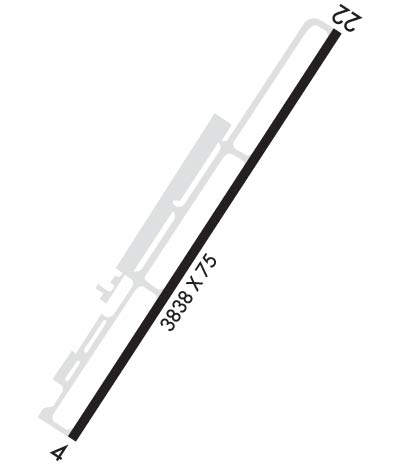
| Lat: N 4143.7 Long: W 07422.6 Elev: 292 Var: +14 Longest Runway: 3838 | ||
| CTAF: 122.8 | ||
| ||||||||||||||||||||||||||||||||||||||||||||
| ||||||||||||||||||||||||||||||||||||||||||||
| Rwy | Rwy | |||||||
| 3838x75 | 3838' | 3838x75 | 3538' | |||||
| Runway ID | Single Wheel | Double Wheel | Double Tandem Wheel | Dual Double Wheel |
| 04/22 | N/A | N/A | N/A | N/A |
| These numbers are Advisory and are not limits. The Airport Manager should have more accurate Weight Limits | ||||
 Airport Diagram might not be current. | |
| Facility Name: | JOSEPH Y RESNICK |
| City Name: | ELLENVILLE |
| County: | ULSTER |
| State abbrev: | NY |
| State Name: | NEW YORK |
| Ownership: | PUBLICLY OWNED |
| Use: | OPEN TO THE PUBLIC |
| Owner's Name: | TOWN OF WAWARSING |
| Address: | 108 CANAL STREET |
| ELLENVILLE, NY 12428 | |
| Owner's Phone: | 845-647-6570 |
| Manager's Name: | TERRY HOUCK |
| Address: | TOWN SUPERVISOR, 108 CANAL STREET |
| ELLENVILLE, NY 12428 | |
| Phone: | 845-647-7800 |
| FAA Region: | EASTERN |
| FAA Field Office: | NYC |
| Date | Sunrise | Sunset |
|---|---|---|
| 09/24/21 Friday | 6:47 | 18:52 |
| 09/25/21 Saturday | 6:48 | 18:50 |
| 09/26/21 Sunday | 6:49 | 18:48 |
| 09/27/21 Monday | 6:50 | 18:47 |
| 09/28/21 Tuesday | 6:51 | 18:45 |
| 09/29/21 Wednesday | 6:52 | 18:43 |
| 09/30/21 Thursday | 6:53 | 18:41 |
| 10/01/21 Friday | 6:54 | 18:40 |
| 10/02/21 Saturday | 6:55 | 18:38 |
| 10/03/21 Sunday | 6:56 | 18:36 |
| 10/04/21 Monday | 6:57 | 18:35 |
| 10/05/21 Tuesday | 6:58 | 18:33 |
| 10/06/21 Wednesday | 6:59 | 18:31 |
| 10/07/21 Thursday | 7:01 | 18:30 |
| Airport Attendance Schedule | 7 Days A Week 0800-DARK |
| Airport Status | OPERATIONAL (This Status can change at any time - please check NOTAMS) |
| Airport Lighting Schedule | ACTVT REIL RWY 04 & 22; MIRL RWY 04/22 - CTAF. |
| Airport Storage Available | Tie Downs, Hanger |
| Extra Services Available | Flight Instruction |
| Wind Indicator | YES - (lighted) |
| Control Tower | NO |
| CTAF Frequency | 122.800 |
| Unicom Frequency | 122.800 |
| Rotating Beacon Color | CLEAR-GREEN (Light Land Airport) |
| Segmented Circle | YES |
| Landing Fee | NO |
| Airport Inspected | STATE - performed by STATE AERONAUTICAL PERSONNEL |
| Inspection Date | 06/11/2020 |
| Type of Fuel Available | Grade 100LL |
| Airframe Repair Service | MINOR |
| Power Plant Repair Service | MINOR |
| Latitude | N4143.7 |
| Longitude | W07422.6 (ESTIMATED) |
| Arpt Elevation | 292ft (ESTIMATED) |
| Magnetic Variation | 14W |
| 1 miles NE | of ELLENVILLE |
| Traffic Pattern Altitude | |
| Sectional Chart | NEW YORK |
| Operations (Reported) | Yearly | Avg. Daily |
|---|---|---|
| General Aviation Transient | 800 | 2 |
| General Aviation Local | 5000 | 14 |
| Air Taxi | 100 | 0 |
| Commerical | 0 | 0 |
| Commuter | 0 | 0 |
| Military | 0 | 0 |
| Aircraft based on Field | |
|---|---|
| General Aviation Singles | 35 |
| General Aviation Multi | 1 |
| Jet Aircraft | 0 |
| General Aviation Helicopters | 1 |
| Military Aircraft | 0 |
| Gliders | 0 |
| Ultralights | 0 |
| FSS on field | NO |
| FSS tie-in | NEW YORK |
| FSS Phone | 1-800-WX-BRIEF |
| Who issues Notams | ISP |
| Notam D service at airport | YES |
| ARTCC Name | NEW YORK |
| Airport Certification | |
| Aircraft Rescue & Firefighting Index | None |
| Airport of Entry | No |
| Custom Landing Rights | No |
| Joint Civil/Military | No |
| Military Landing rights | No |
| NATIONAL PLAN OF INTEGRATED AIRPORT SYSTEMS (NPIAS) |
| GRANT AGREEMENTS UNDER FAAP/ADAP/AIP |
| ASSURANCES PURSUANT TO TITLE VI, CIVIL RIGHTS ACT OF 1964 |
| AVOID OVERFLIGHT OF SCHOOL & VILLAGE WHEN TAKING OFF RWY 22 OR APCH TO RWY 4, HEL OPNS FOLLOW FIXED WING FLT PAT. |
| FOR CD CTC NEW YORK APCH AT 516-683-2448 |
| COLD TEMPERATURE AIRPORT. ALTITUDE CORRECTION REQUIRED AT OR BELOW -6C. |
| AVOID OVERFLIGHT OF HOSP & SCHOOL BUILDINGS APPROX 1 MILE SW OF RWY 22 & PRISON APPROX 1/2 MILE NE OF ARPT. |
| RWY 04; 60 FT TREES 200 FT FM RWY, 191 RIGHT. |
| RWY 22; 8 FT FENCE CROSSES RWY 24 FT FM THR. |
| AWOS FREQUENCY 122.8 - 5 CLICKS. |
Airport Communications & Frequencies:
| ||||||||||||||
| Runway: 04 | Runway: 22 | ||
| Mag heading: | 47° | Mag heading: | 227° |
| Rwy Slope: | -.17% Down | Rwy Slope: | .17% Up |
| Approach: | Approach: | ||
| Pattern: | Left Traffic | Pattern: | Right Traffic |
| Markings: | NONPRECISION INSTRUMENT | Markings: | NONPRECISION INSTRUMENT |
| Marking Condition: | GOOD | Marking Condition: | GOOD |
| Arresting Dev: | Arresting Dev: | ||
| Lat & Long: | N4143.5 W07422.8 | Lat. & Long.: | N4144.0 W07422.4 |
| Elev: | 289.7 ft. MSL | Elev: | 283.1 ft. MSL |
| TCH: | 40 ft. AGL | TCH: | 39 ft. AGL |
| Visual Glide Path: | 3.50 degrees | Visual Glide Path: | 3.00 degrees |
| Displaced Threshold: | No | Displaced Threshold: | 300 feet |
| Touchdown Zone: | YES | Touchdown Zone: | YES |
| Touchdown Elev.: | 289.7 feet | Touchdown Elev.: | 289.6 feet |
| Visual Glide Slope: | 2-Light PAPI on LEFT side of Runway; OPR CONSLY. | Visual Glide Slope: | 2-Light PAPI on LEFT side of Runway; OPR CONSLY. |
| RVR Equipment: | RVR Equipment: | ||
| RVV Equipment: | NO | RVV Equipment: | NO |
| Approach Lights: | Approach Lights: | ||
| REIL: | YES | REIL: | YES |
| Centerline Lights: | NO | Centerline Lights: | NO |
| Touchdown lights: | NO | Touchdown lights: | NO |
| Runway Category: | Runway with a Non-precision Approach | Runway Category: | Runway with a Non-precision Approach |
| Declared Distances: | TORA:3838' TODA:3838' ASDA:3838' LDA:3538' | Declared Distances: | TORA:3838' TODA:3838' ASDA:3838' LDA:3538' |
| Obstructions: | TREES | Obstructions: | CROPS |
| Marked: | NOT Marked/Lighted | Marked: | NOT Marked/Lighted |
| Clearance slope: | Clearance slope: | RWY 22 APCH RATIO 0:1 TO DTHR BASED ON 8 FT FENCE 243 FT LEFT OF DTHR. RWY 22 CLNC OBSTN IS CORN IN FIELD. | |
| Obstruction height: | 68 feet AGL | Obstruction height: | 8 feet AGL |
| Dist. from runway: | 260 feet | Dist. from runway: | 200 feet |
| Centerline offset: | 164 left of centerline | Centerline offset: | |
| Comments: | RWY 04 65 FT TREES, 0 FT FM RWY THLD, 206 FT RIGHT. | Comments: | RY 22 +35-55 FT TREES, 0-80 FT FROM RY THRESHOLD, 90-200 FT LEFT OF CNTRLN; -6 FT CREEK 0B 50 FT FROM THRESHOLD; +8 FT FENCE CROSSES RUNWAY 24 FT FROM THRESHOLD. |
Thanks for using FltPlan.com
all rights reserved © 1999-2021 by Flight Plan LLC
