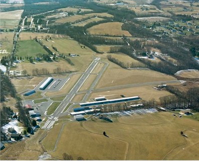
| ALEXANDRIA PITTSTOWN NJ |
| |
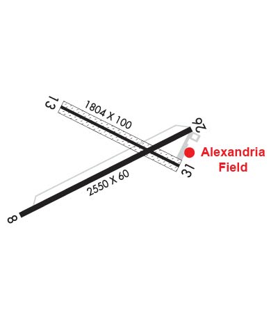
| Lat: N 4035.3 Long: W 07501.2 Elev: 480 Var: +10 Longest Runway: 2550 | ||
| CTAF: 122.97 | ||
| ||||||||||||||||||||||||||||||||||||||||||||||||||||||||||||||
| ||||||||||||||||||||||||||||||||||||||||||||||||||||||||||||||
| Rwy | Rwy | |||||||
| 2550x60 | 2550' | 2550x60 | 2550' | |||||
| 1804x100 | 1804' | 1804x100 | 1804' | |||||
| Runway ID | Single Wheel | Double Wheel | Double Tandem Wheel | Dual Double Wheel |
| 08/26 | N/A | N/A | N/A | N/A |
| 13/31 | N/A | N/A | N/A | N/A |
| These numbers are Advisory and are not limits. The Airport Manager should have more accurate Weight Limits | ||||
 Airport Diagram might not be current. | |
| Facility Name: | ALEXANDRIA |
| City Name: | PITTSTOWN |
| County: | HUNTERDON |
| State abbrev: | NJ |
| State Name: | NEW JERSEY |
| Ownership: | PRIVATELY OWNED |
| Use: | OPEN TO THE PUBLIC |
| Owner's Name: | ALEXANDRIA AIRPARK, LLC |
| Address: | 63 AIRPORT ROAD |
| PITTSTOWN, NJ 08867 | |
| Owner's Phone: | 908-730-9223 |
| Manager's Name: | W. FRITSCHE - L. CASTNER |
| Address: | 63 AIRPORT ROAD |
| PITTSTOWN, NJ 08867 | |
| Phone: | 908-730-9223 |
| FAA Region: | EASTERN |
| FAA Field Office: | HAR |
| Date | Sunrise | Sunset |
|---|---|---|
| 09/24/21 Friday | 6:49 | 18:54 |
| 09/25/21 Saturday | 6:50 | 18:53 |
| 09/26/21 Sunday | 6:51 | 18:51 |
| 09/27/21 Monday | 6:52 | 18:49 |
| 09/28/21 Tuesday | 6:53 | 18:48 |
| 09/29/21 Wednesday | 6:54 | 18:46 |
| 09/30/21 Thursday | 6:55 | 18:44 |
| 10/01/21 Friday | 6:56 | 18:43 |
| 10/02/21 Saturday | 6:57 | 18:41 |
| 10/03/21 Sunday | 6:58 | 18:39 |
| 10/04/21 Monday | 6:59 | 18:38 |
| 10/05/21 Tuesday | 7:00 | 18:36 |
| 10/06/21 Wednesday | 7:01 | 18:34 |
| 10/07/21 Thursday | 7:02 | 18:33 |
| Airport Attendance Schedule | 7 Days A Week 0800-DUSK |
| Airport Status | OPERATIONAL (This Status can change at any time - please check NOTAMS) |
| Airport Lighting Schedule | ACTVT MIRL RY 08/26 - 121.8.; ACTIVATE ROTG BCN - 121.8. |
| Airport Storage Available | Tie Downs, Hanger |
| Extra Services Available | Flight Instruction, Parachute Jumping, Aircraft Rental, Aircraft Sales |
| Wind Indicator | YES - (lighted) |
| Control Tower | NO |
| CTAF Frequency | 122.975 |
| Unicom Frequency | 122.975 |
| Rotating Beacon Color | CLEAR-GREEN (Light Land Airport) |
| Segmented Circle | NO |
| Landing Fee | NO |
| Airport Inspected | STATE - performed by STATE AERONAUTICAL PERSONNEL |
| Inspection Date | 06/04/2021 |
| Type of Fuel Available | Grade 100LL, JET A (freeze point -40C); -1024 HR SELF-SERVICE |
| Airframe Repair Service | MAJOR |
| Power Plant Repair Service | MAJOR |
| Latitude | N4035.3 |
| Longitude | W07501.2 (ESTIMATED) |
| Arpt Elevation | 480ft (SURVEYED) |
| Magnetic Variation | 10W |
| 2 miles W | of PITTSTOWN |
| Traffic Pattern Altitude | |
| Sectional Chart | NEW YORK |
| Operations (Reported) | Yearly | Avg. Daily |
|---|---|---|
| General Aviation Transient | 7295 | 20 |
| General Aviation Local | 11072 | 30 |
| Air Taxi | 0 | 0 |
| Commerical | 0 | 0 |
| Commuter | 0 | 0 |
| Military | 0 | 0 |
| Aircraft based on Field | |
|---|---|
| General Aviation Singles | 80 |
| General Aviation Multi | 1 |
| Jet Aircraft | 0 |
| General Aviation Helicopters | 1 |
| Military Aircraft | 0 |
| Gliders | 0 |
| Ultralights | 2 |
| FSS on field | NO |
| FSS tie-in | MILLVILLE |
| FSS Phone | 1-800-WX-BRIEF |
| Who issues Notams | MIV |
| Notam D service at airport | YES |
| ARTCC Name | NEW YORK |
| Airport Certification | |
| Aircraft Rescue & Firefighting Index | None |
| Airport of Entry | No |
| Custom Landing Rights | No |
| Joint Civil/Military | No |
| Military Landing rights | No |
| THIS AIRPORT HAS BEEN SURVEYED BY THE NATIONAL GEODETIC SURVEY. |
| TAXI ON PAVEMENT ONLY. |
| HEL TKOF AND LDGS RSTRD TO RWY 08/26 ONLY. |
| HEL USE FIXED-WING TFC PAT AND ALTS. |
| CTC ARPT MGR 908-730-9223 PRIOR TO CONDUCTING HEL TRNG ACT. |
| NO TGL OR STA ALLOWED. |
| FOR CD CTC ALLENTOWN APCH AT 800-728-6322. |
| RWY 13/3 1 25 FT WIDE ASPH STRIP FULL LENGTH DOWN CENTER OF RWY. TURF PORTION OF RWY UNUSABLE. |
Airport Communications & Frequencies:
| ||||||||||||||||||
| Runway: 08 | Runway: 26 | ||
| Mag heading: | 74° | Mag heading: | 254° |
| Rwy Slope: | .67% Up | Rwy Slope: | -.67% Down |
| Approach: | Approach: | ||
| Pattern: | Left Traffic | Pattern: | Left Traffic |
| Markings: | NONPRECISION INSTRUMENT | Markings: | NONPRECISION INSTRUMENT |
| Marking Condition: | GOOD | Marking Condition: | GOOD |
| Arresting Dev: | Arresting Dev: | ||
| Lat & Long: | N4035.1 W07501.4 | Lat. & Long.: | N4035.3 W07500.9 |
| Elev: | 463.0 ft. MSL | Elev: | 480.0 ft. MSL |
| TCH: | 30 ft. AGL | TCH: | 28 ft. AGL |
| Visual Glide Path: | 4.00 degrees | Visual Glide Path: | 3.75 degrees |
| Displaced Threshold: | No | Displaced Threshold: | No |
| Touchdown Zone: | YES | Touchdown Zone: | YES |
| Touchdown Elev.: | 480.0 feet | Touchdown Elev.: | 480.0 feet |
| Visual Glide Slope: | 2-Light PAPI on RIGHT side of Runway | Visual Glide Slope: | 2-Light PAPI on LEFT side of Runway; PAPI UNUSBL BYD 2 DEGS LEFT OF CNTRLN. |
| RVR Equipment: | RVR Equipment: | ||
| RVV Equipment: | NO | RVV Equipment: | NO |
| Approach Lights: | Approach Lights: | ||
| REIL: | NO | REIL: | NO |
| Centerline Lights: | NO | Centerline Lights: | NO |
| Touchdown lights: | NO | Touchdown lights: | NO |
| Runway Category: | Runway with a Non-precision Approach | Runway Category: | Runway with a Visual Approach |
| Declared Distances: | Declared Distances: | ||
| Obstructions: | TREE | Obstructions: | TREE |
| Marked: | NOT Marked/Lighted | Marked: | NOT Marked/Lighted |
| Clearance slope: | 5:1 | Clearance slope: | |
| Obstruction height: | 50 feet AGL | Obstruction height: | 71 feet AGL |
| Dist. from runway: | 481 feet | Dist. from runway: | 232 feet |
| Centerline offset: | 102 left of centerline | Centerline offset: | 208 feet left of centerline |
| Comments: | Comments: | +33 FT TREE, 58 FT FM RWY END, 108 FT L. |
| Runway: 13 | Runway: 31 | ||
| Mag heading: | 128° | Mag heading: | 308° |
| Rwy Slope: | .81% Up | Rwy Slope: | -.81% Down |
| Approach: | Approach: | ||
| Pattern: | Left Traffic | Pattern: | Left Traffic |
| Markings: | NUMBERS ONLY | Markings: | NUMBERS ONLY |
| Marking Condition: | FAIR | Marking Condition: | FAIR |
| Arresting Dev: | Arresting Dev: | ||
| Lat & Long: | N4035.4 W07501.3 | Lat. & Long.: | N4035.2 W07501.0 |
| Elev: | 444.0 ft. MSL | Elev: | 458.7 ft. MSL |
| TCH: | TCH: | ||
| Visual Glide Path: | Visual Glide Path: | ||
| Displaced Threshold: | No | Displaced Threshold: | No |
| Touchdown Zone: | YES | Touchdown Zone: | YES |
| Touchdown Elev.: | 458.7 feet | Touchdown Elev.: | 458.7 feet |
| Visual Glide Slope: | Visual Glide Slope: | ||
| RVR Equipment: | RVR Equipment: | ||
| RVV Equipment: | NO | RVV Equipment: | NO |
| Approach Lights: | Approach Lights: | ||
| REIL: | NO | REIL: | NO |
| Centerline Lights: | NO | Centerline Lights: | NO |
| Touchdown lights: | NO | Touchdown lights: | NO |
| Runway Category: | Runway with a Visual Approach | Runway Category: | Runway with a Visual Approach |
| Declared Distances: | Declared Distances: | ||
| Obstructions: | TREE | Obstructions: | TREE |
| Marked: | NOT Marked/Lighted | Marked: | NOT Marked/Lighted |
| Clearance slope: | 14:1 | Clearance slope: | 7:1 |
| Obstruction height: | 16 feet AGL | Obstruction height: | 64 feet AGL |
| Dist. from runway: | 433 feet | Dist. from runway: | 666 feet |
| Centerline offset: | 95 left of centerline | Centerline offset: | 142 feet left of centerline |
| Comments: | Comments: | +47 FT TREE, 112 FT FM RWY END, 117 FT L. |
Thanks for using FltPlan.com
all rights reserved © 1999-2021 by Flight Plan LLC