
| WURTSBORO-SULLIVAN COUNTY WURTSBORO NY |
| |
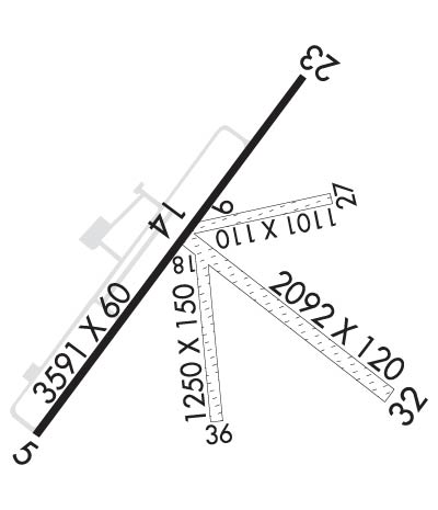
| Lat: N 4135.8 Long: W 07427.5 Elev: 548 Var: +12 Longest Runway: 3591 | ||
| CTAF: 122.8 | ||
| |||||
|
| Rwy | Rwy | |||||||
| 3591x60 | 3358' | 3591x60 | 3591' | |||||
| 1101x110 | 1101' | 1101x110 | 1101' | |||||
| 2092x120 | 2092' | 2092x120 | 2092' | |||||
| 1250x150 | 1250' | 1250x150 | 1250' | |||||
| Runway ID | Single Wheel | Double Wheel | Double Tandem Wheel | Dual Double Wheel |
| 05/23 | 30,000 | N/A | N/A | N/A |
| 09/27 | N/A | N/A | N/A | N/A |
| 14/32 | N/A | N/A | N/A | N/A |
| 18/36 | N/A | N/A | N/A | N/A |
| These numbers are Advisory and are not limits. The Airport Manager should have more accurate Weight Limits | ||||
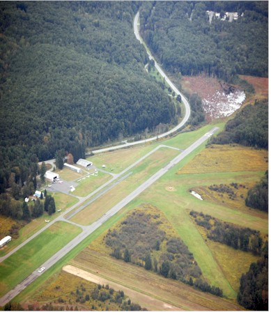
 Airport Diagram might not be current. | |
| Facility Name: | WURTSBORO-SULLIVAN COUNTY |
| City Name: | WURTSBORO |
| County: | SULLIVAN |
| State abbrev: | NY |
| State Name: | NEW YORK |
| Ownership: | PRIVATELY OWNED |
| Use: | OPEN TO THE PUBLIC |
| Owner's Name: | WURTSBORO AIRPORT FOUNDATION |
| Address: | WURTSBORO AIRPORT, ROUTE 209, P.O. BOX 129 |
| WURTSBORO, NY 12790 | |
| Owner's Phone: | 845-888-2791 |
| Manager's Name: | DANIEL YATES |
| Address: | WURTSBORO AIRPARK, LLC, 50 BARONE RD |
| WURTSBORO, NY 12790 | |
| Phone: | (845) 888-2791 |
| FAA Region: | EASTERN |
| FAA Field Office: | NYC |
| Date | Sunrise | Sunset |
|---|---|---|
| 09/24/21 Friday | 6:47 | 18:52 |
| 09/25/21 Saturday | 6:48 | 18:50 |
| 09/26/21 Sunday | 6:49 | 18:49 |
| 09/27/21 Monday | 6:50 | 18:47 |
| 09/28/21 Tuesday | 6:51 | 18:45 |
| 09/29/21 Wednesday | 6:52 | 18:43 |
| 09/30/21 Thursday | 6:53 | 18:42 |
| 10/01/21 Friday | 6:54 | 18:40 |
| 10/02/21 Saturday | 6:55 | 18:38 |
| 10/03/21 Sunday | 6:56 | 18:37 |
| 10/04/21 Monday | 6:58 | 18:35 |
| 10/05/21 Tuesday | 6:59 | 18:33 |
| 10/06/21 Wednesday | 7:00 | 18:32 |
| 10/07/21 Thursday | 7:01 | 18:30 |
| Airport Attendance Schedule | 7 Days A Week 0900-1700; WINTER MONTHS ATTENDED TILL DUSK. |
| Airport Status | OPERATIONAL (This Status can change at any time - please check NOTAMS) |
| Airport Lighting Schedule | |
| Airport Storage Available | Tie Downs, Hanger |
| Extra Services Available | Glider, Flight Instruction, Aircraft Rental, Aircraft Sales, Glider Towing |
| Wind Indicator | YES - (unlit) |
| Control Tower | NO |
| CTAF Frequency | 122.800 |
| Unicom Frequency | 122.800 |
| Rotating Beacon Color | |
| Segmented Circle | NO |
| Landing Fee | NO |
| Airport Inspected | STATE - performed by STATE AERONAUTICAL PERSONNEL |
| Inspection Date | 09/01/2020 |
| Type of Fuel Available | Grade 100LL |
| Airframe Repair Service | NONE |
| Power Plant Repair Service | NONE |
| Latitude | N4135.8 |
| Longitude | W07427.5 (ESTIMATED) |
| Arpt Elevation | 548ft (SURVEYED) |
| Magnetic Variation | 12W |
| 2 miles NE | of WURTSBORO |
| Traffic Pattern Altitude | |
| Sectional Chart | NEW YORK |
| Operations (Reported) | Yearly | Avg. Daily |
|---|---|---|
| General Aviation Transient | 19500 | 53 |
| General Aviation Local | 50500 | 138 |
| Air Taxi | 0 | 0 |
| Commerical | 0 | 0 |
| Commuter | 0 | 0 |
| Military | 0 | 0 |
| Aircraft based on Field | |
|---|---|
| General Aviation Singles | 0 |
| General Aviation Multi | 0 |
| Jet Aircraft | 0 |
| General Aviation Helicopters | 0 |
| Military Aircraft | 0 |
| Gliders | 0 |
| Ultralights | 0 |
| FSS on field | NO |
| FSS tie-in | NEW YORK |
| FSS Phone | 1-800-WX-BRIEF |
| Who issues Notams | ISP |
| Notam D service at airport | YES |
| ARTCC Name | NEW YORK |
| Airport Certification | |
| Aircraft Rescue & Firefighting Index | None |
| Airport of Entry | No |
| Custom Landing Rights | No |
| Joint Civil/Military | No |
| Military Landing rights | No |
| NATIONAL PLAN OF INTEGRATED AIRPORT SYSTEMS (NPIAS) |
| DEER ON & INVOF ARPT. |
| EXTSV GLIDER ACTIVITY. |
| FOR CD CTC NEW YORK APCH AT 516-683-2448 |
Airport Communications & Frequencies:
| ||||||||||||||
| Runway: 05 | Runway: 23 | ||
| Mag heading: | 48° | Mag heading: | 228° |
| Rwy Slope: | -.30% Down | Rwy Slope: | .30% Up |
| Approach: | Approach: | ||
| Pattern: | Left Traffic | Pattern: | Left Traffic |
| Markings: | NONPRECISION INSTRUMENT | Markings: | NONPRECISION INSTRUMENT |
| Marking Condition: | POOR; RY 05/23 MKGS FADED. | Marking Condition: | POOR; RY 05/23 MKGS FADED. |
| Arresting Dev: | Arresting Dev: | ||
| Lat & Long: | N4135.6 W07427.8 | Lat. & Long.: | N4136.1 W07427.4 |
| Elev: | 547.8 ft. MSL | Elev: | 537.0 ft. MSL |
| TCH: | TCH: | ||
| Visual Glide Path: | Visual Glide Path: | ||
| Displaced Threshold: | 233 feet | Displaced Threshold: | No |
| Touchdown Zone: | YES | Touchdown Zone: | YES |
| Touchdown Elev.: | 548.4 feet | Touchdown Elev.: | 548.4 feet |
| Visual Glide Slope: | Visual Glide Slope: | ||
| RVR Equipment: | RVR Equipment: | ||
| RVV Equipment: | NO | RVV Equipment: | NO |
| Approach Lights: | Approach Lights: | ||
| REIL: | NO | REIL: | NO |
| Centerline Lights: | NO | Centerline Lights: | NO |
| Touchdown lights: | NO | Touchdown lights: | NO |
| Runway Category: | Runway with a Non-precision Approach | Runway Category: | Runway with a Visual Approach |
| Declared Distances: | Declared Distances: | ||
| Obstructions: | POLE | Obstructions: | TREES |
| Marked: | NOT Marked/Lighted | Marked: | NOT Marked/Lighted |
| Clearance slope: | 17:1; APCH RATIO 48:1 TO DSPLCD THLD. | Clearance slope: | 6:1 |
| Obstruction height: | 14 feet AGL | Obstruction height: | 33 feet AGL |
| Dist. from runway: | 440 feet | Dist. from runway: | 430 feet |
| Centerline offset: | 35 left of centerline | Centerline offset: | 107 feet left of centerline |
| Comments: | RWY 05 HAS +8 FT BERM 50 FT FM THLD; +88 FT TREE, 139 FT FM THLD; 165 FT RIGHT. | Comments: | RY 23 HAS +40 FT TREE, 37 FT FM RY BEGINNING, 161 FT RIGHT, AND +38 FT TREES 159 FT FM RY BEGINNING 84 FT LEFT |
| Runway: 09 | Runway: 27 | ||
| Mag heading: | 90° | Mag heading: | 270° |
| Rwy Slope: | -.74% Down | Rwy Slope: | .74% Up |
| Approach: | Approach: | ||
| Pattern: | Left Traffic | Pattern: | Left Traffic |
| Markings: | Markings: | ||
| Marking Condition: | Marking Condition: | ||
| Arresting Dev: | Arresting Dev: | ||
| Lat & Long: | N4135.9 W07427.5 | Lat. & Long.: | N4135.9 W07427.3 |
| Elev: | 541.9 ft. MSL | Elev: | 533.8 ft. MSL |
| TCH: | TCH: | ||
| Visual Glide Path: | Visual Glide Path: | ||
| Displaced Threshold: | No | Displaced Threshold: | No |
| Touchdown Zone: | YES | Touchdown Zone: | YES |
| Touchdown Elev.: | 541.9 feet | Touchdown Elev.: | 541.9 feet |
| Visual Glide Slope: | Visual Glide Slope: | ||
| RVR Equipment: | RVR Equipment: | ||
| RVV Equipment: | NO | RVV Equipment: | NO |
| Approach Lights: | Approach Lights: | ||
| REIL: | NO | REIL: | NO |
| Centerline Lights: | NO | Centerline Lights: | NO |
| Touchdown lights: | NO | Touchdown lights: | NO |
| Runway Category: | Runway with a Visual Approach | Runway Category: | Runway with a Visual Approach |
| Declared Distances: | Declared Distances: | ||
| Obstructions: | TREES | Obstructions: | TREES |
| Marked: | NOT Marked/Lighted | Marked: | NOT Marked/Lighted |
| Clearance slope: | 10:1 | Clearance slope: | |
| Obstruction height: | 105 feet AGL | Obstruction height: | 65 feet AGL |
| Dist. from runway: | 1110 feet | Dist. from runway: | 0 feet |
| Centerline offset: | 19 left of centerline | Centerline offset: | |
| Comments: | Comments: |
| Runway: 14 | Runway: 32 | ||
| Mag heading: | 139° | Mag heading: | 319° |
| Rwy Slope: | -.58% Down | Rwy Slope: | .58% Up |
| Approach: | Approach: | ||
| Pattern: | Left Traffic | Pattern: | Left Traffic |
| Markings: | Markings: | ||
| Marking Condition: | Marking Condition: | ||
| Arresting Dev: | Arresting Dev: | ||
| Lat & Long: | N4135.9 W07427.6 | Lat. & Long.: | N4135.7 W07427.2 |
| Elev: | 543.3 ft. MSL | Elev: | 531.1 ft. MSL |
| TCH: | TCH: | ||
| Visual Glide Path: | Visual Glide Path: | ||
| Displaced Threshold: | No | Displaced Threshold: | No |
| Touchdown Zone: | YES | Touchdown Zone: | YES |
| Touchdown Elev.: | 543.3 feet | Touchdown Elev.: | 543.3 feet |
| Visual Glide Slope: | Visual Glide Slope: | ||
| RVR Equipment: | RVR Equipment: | ||
| RVV Equipment: | NO | RVV Equipment: | NO |
| Approach Lights: | Approach Lights: | ||
| REIL: | NO | REIL: | NO |
| Centerline Lights: | NO | Centerline Lights: | NO |
| Touchdown lights: | NO | Touchdown lights: | NO |
| Runway Category: | Runway with a Visual Approach | Runway Category: | Runway with a Visual Approach |
| Declared Distances: | Declared Distances: | ||
| Obstructions: | HILL | Obstructions: | TREES |
| Marked: | NOT Marked/Lighted | Marked: | NOT Marked/Lighted |
| Clearance slope: | 6:1 | Clearance slope: | |
| Obstruction height: | 210 feet AGL | Obstruction height: | 63 feet AGL |
| Dist. from runway: | 1400 feet | Dist. from runway: | 17 feet |
| Centerline offset: | Centerline offset: | 94 feet right of centerline | |
| Comments: | Comments: |
| Runway: 18 | Runway: 36 | ||
| Mag heading: | 187° | Mag heading: | 7° |
| Rwy Slope: | -.30% Down | Rwy Slope: | .30% Up |
| Approach: | Approach: | ||
| Pattern: | Left Traffic | Pattern: | Left Traffic |
| Markings: | Markings: | ||
| Marking Condition: | Marking Condition: | ||
| Arresting Dev: | Arresting Dev: | ||
| Lat & Long: | N4135.8 W07427.5 | Lat. & Long.: | N4135.6 W07427.5 |
| Elev: | 539.4 ft. MSL | Elev: | 535.7 ft. MSL |
| TCH: | TCH: | ||
| Visual Glide Path: | Visual Glide Path: | ||
| Displaced Threshold: | No | Displaced Threshold: | No |
| Touchdown Zone: | YES | Touchdown Zone: | YES |
| Touchdown Elev.: | 539.4 feet | Touchdown Elev.: | 539.4 feet |
| Visual Glide Slope: | Visual Glide Slope: | ||
| RVR Equipment: | RVR Equipment: | ||
| RVV Equipment: | NO | RVV Equipment: | NO |
| Approach Lights: | Approach Lights: | ||
| REIL: | NO | REIL: | NO |
| Centerline Lights: | NO | Centerline Lights: | NO |
| Touchdown lights: | NO | Touchdown lights: | NO |
| Runway Category: | Runway with a Visual Approach | Runway Category: | Runway with a Visual Approach |
| Declared Distances: | Declared Distances: | ||
| Obstructions: | HILL | Obstructions: | TREES |
| Marked: | NOT Marked/Lighted | Marked: | NOT Marked/Lighted |
| Clearance slope: | 5:1 | Clearance slope: | |
| Obstruction height: | 200 feet AGL | Obstruction height: | 58 feet AGL |
| Dist. from runway: | 1110 feet | Dist. from runway: | 47 feet |
| Centerline offset: | Centerline offset: | 82 feet right of centerline | |
| Comments: | Comments: |
Thanks for using FltPlan.com
all rights reserved © 1999-2021 by Flight Plan LLC