
| RED LION VINCENTOWN NJ |
| |
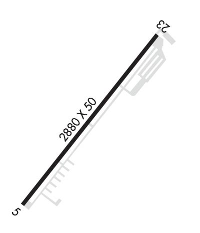
| Lat: N 3954.2 Long: W 07445.0 Elev: 54 Var: +10 Longest Runway: 2880 | ||
| CTAF: 122.8 | ||
| ||||||||||||||||||||||||||||||||
| ||||||||||||||||||||||||||||||||
| Rwy | Rwy | |||||||
| 2880x50 | 2880' | 2880x50 | 2880' | |||||
| Runway ID | Single Wheel | Double Wheel | Double Tandem Wheel | Dual Double Wheel |
| These numbers are Advisory and are not limits. The Airport Manager should have more accurate Weight Limits | ||||
 Airport Diagram might not be current. | |
| Facility Name: | RED LION |
| City Name: | VINCENTOWN |
| County: | BURLINGTON |
| State abbrev: | NJ |
| State Name: | NEW JERSEY |
| Ownership: | PRIVATELY OWNED |
| Use: | OPEN TO THE PUBLIC |
| Owner's Name: | AFFILIATED AIR SERVICES INC |
| Address: | 235 RED LION RD |
| SOUTHAMPTON, NJ 08088 | |
| Owner's Phone: | 609-859-2266 |
| Manager's Name: | RAYMOND P. AND ARLENE DANIELS |
| Address: | 235 RED LION RD |
| SOUTHAMPTON, NJ 08088 | |
| Phone: | 609-859-8544 |
| FAA Region: | EASTERN |
| FAA Field Office: | HAR |
| Date | Sunrise | Sunset |
|---|---|---|
| 02/27/19 Wednesday | 6:36 | 17:49 |
| 02/28/19 Thursday | 6:34 | 17:50 |
| 03/01/19 Friday | 6:33 | 17:51 |
| 03/02/19 Saturday | 6:31 | 17:52 |
| 03/03/19 Sunday | 6:30 | 17:53 |
| 03/04/19 Monday | 6:28 | 17:54 |
| 03/05/19 Tuesday | 6:27 | 17:55 |
| 03/06/19 Wednesday | 6:25 | 17:56 |
| 03/07/19 Thursday | 6:24 | 17:57 |
| 03/08/19 Friday | 6:22 | 17:58 |
| 03/09/19 Saturday | 6:21 | 17:59 |
| 03/10/19 Sunday | 7:19 | 19:00 |
| 03/11/19 Monday | 7:17 | 19:02 |
| 03/12/19 Tuesday | 7:16 | 19:03 |
| Airport Attendance Schedule | 7 Days A Week 0800-DARK |
| Airport Status | OPERATIONAL (This Status can change at any time - please check NOTAMS) |
| Airport Lighting Schedule | ACTVT MIRL RWY 05/23 - 123.5. |
| Airport Storage Available | Tie Downs |
| Extra Services Available | NONE |
| Wind Indicator | YES - (lighted) |
| Control Tower | NO |
| CTAF Frequency | 122.800 |
| Unicom Frequency | 122.800 |
| Rotating Beacon Color | CLEAR-GREEN (Light Land Airport) |
| Segmented Circle | NO |
| Landing Fee | NO |
| Airport Inspected | STATE - performed by STATE AERONAUTICAL PERSONNEL |
| Inspection Date | 09/25/2018 |
| Type of Fuel Available | Grade 100LL |
| Airframe Repair Service | MAJOR |
| Power Plant Repair Service | MAJOR |
| Latitude | N3954.2 |
| Longitude | W07445.0 (ESTIMATED) |
| Arpt Elevation | 54ft (SURVEYED) |
| Magnetic Variation | 10W |
| 2 miles S | of VINCENTOWN |
| Traffic Pattern Altitude | |
| Sectional Chart | WASHINGTON |
| Operations (Reported) | Yearly | Avg. Daily |
|---|---|---|
| General Aviation Transient | 2756 | 8 |
| General Aviation Local | 5579 | 15 |
| Air Taxi | 0 | 0 |
| Commerical | 0 | 0 |
| Commuter | 0 | 0 |
| Military | 0 | 0 |
| Aircraft based on Field | |
|---|---|
| General Aviation Singles | 14 |
| General Aviation Multi | 1 |
| Jet Aircraft | 0 |
| General Aviation Helicopters | 0 |
| Military Aircraft | 0 |
| Gliders | 0 |
| Ultralights | 0 |
| FSS on field | NO |
| FSS tie-in | MILLVILLE |
| FSS Phone | 1-800-WX-BRIEF |
| Who issues Notams | MIV |
| Notam D service at airport | YES |
| ARTCC Name | NEW YORK |
| Airport Certification | |
| Aircraft Rescue & Firefighting Index | None |
| Airport of Entry | No |
| Custom Landing Rights | No |
| Joint Civil/Military | No |
| Military Landing rights | No |
| NATIONAL PLAN OF INTEGRATED AIRPORT SYSTEMS (NPIAS) |
| RUNWAY MARKINGS NOT VISIBLE. |
| DEER & BIRDS ON & INVOF APRT. |
| RWY 05/2 3 NSTD MIRL; RWY 05 THLD LGTS INSTALLED 110 FT BYD THLD. |
| Runway: 05 | Runway: 23 | ||
| Mag heading: | 48° | Mag heading: | 228° |
| Rwy Slope: | -.38% Down | Rwy Slope: | .38% Up |
| Approach: | Approach: | ||
| Pattern: | Left Traffic | Pattern: | Left Traffic |
| Markings: | NONSTANDARD | Markings: | NONSTANDARD |
| Marking Condition: | POOR; NSTD THLD MKGS; APRX 50 FT LONG. | Marking Condition: | POOR; NSTD THLD MKGS APRX 50 FT LONG. |
| Arresting Dev: | Arresting Dev: | ||
| Lat & Long: | N3954.1 W07445.2 | Lat. & Long.: | N3954.4 W07444.8 |
| Elev: | 54.0 ft. MSL | Elev: | 43.0 ft. MSL |
| TCH: | 28 ft. AGL | TCH: | 35 ft. AGL |
| Visual Glide Path: | 4.00 degrees | Visual Glide Path: | 5.00 degrees |
| Displaced Threshold: | No | Displaced Threshold: | No |
| Touchdown Zone: | YES | Touchdown Zone: | YES |
| Touchdown Elev.: | 54.0 feet | Touchdown Elev.: | 54.0 feet |
| Visual Glide Slope: | 2-Light PAPI on LEFT side of Runway; PAPI OTS INDEFLY | Visual Glide Slope: | 2-Light PAPI on RIGHT side of Runway; PAPI OTS INDEF. |
| RVR Equipment: | RVR Equipment: | ||
| RVV Equipment: | NO | RVV Equipment: | NO |
| Approach Lights: | Approach Lights: | ||
| REIL: | NO | REIL: | NO |
| Centerline Lights: | NO | Centerline Lights: | NO |
| Touchdown lights: | NO | Touchdown lights: | NO |
| Runway Category: | Runway with a Non-precision Approach | Runway Category: | Runway with a Visual Approach |
| Declared Distances: | Declared Distances: | ||
| Obstructions: | TREES | Obstructions: | TREES |
| Marked: | NOT Marked/Lighted | Marked: | NOT Marked/Lighted |
| Clearance slope: | Clearance slope: | 7:1; 12:1 BASED ON DSPLCD THLD. | |
| Obstruction height: | 58 feet AGL | Obstruction height: | 75 feet AGL |
| Dist. from runway: | 225 feet | Dist. from runway: | 795 feet |
| Centerline offset: | 129 left of centerline | Centerline offset: | |
| Comments: | +35 FT TREE 143 FT FROM RWY END 114 FT R. | Comments: |
Thanks for using FltPlan.com
all rights reserved © 1999-2019 by Flight Plan LLC
