
| JAARS-TOWNSEND WAXHAW NC |
| |
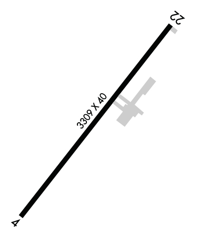
| Lat: N 3451.8 Long: W 08044.9 Elev: 602 Var: +07 Longest Runway: 3309 | ||
| CTAF: 123.0 | ||
| ||||||
|
| Rwy | Rwy | |||||||
| 3309x40 | 3309' | 3309x40 | 3109' | |||||
| Runway ID | Single Wheel | Double Wheel | Double Tandem Wheel | Dual Double Wheel |
| 04/22 | N/A | N/A | N/A | N/A |
| These numbers are Advisory and are not limits. The Airport Manager should have more accurate Weight Limits | ||||
 Airport Diagram might not be current. | |
| Facility Name: | JAARS-TOWNSEND |
| City Name: | WAXHAW |
| County: | UNION |
| State abbrev: | NC |
| State Name: | NORTH CAROLINA |
| Ownership: | PRIVATELY OWNED |
| Use: | OPEN TO THE PUBLIC |
| Owner's Name: | JAARS INC. |
| Address: | PO BOX 248 |
| WAXHAW, NC 28173 | |
| Owner's Phone: | 704-843-6220 |
| Manager's Name: | DAN MILLER |
| Address: | 7710 JAARS ROAD |
| WAXHAW, NC 28173 | |
| Phone: | 704-843-6220 |
| FAA Region: | SOUTHERN |
| FAA Field Office: | MEM |
| Date | Sunrise | Sunset |
|---|---|---|
| 09/24/21 Friday | 7:12 | 19:17 |
| 09/25/21 Saturday | 7:13 | 19:16 |
| 09/26/21 Sunday | 7:14 | 19:14 |
| 09/27/21 Monday | 7:14 | 19:13 |
| 09/28/21 Tuesday | 7:15 | 19:12 |
| 09/29/21 Wednesday | 7:16 | 19:10 |
| 09/30/21 Thursday | 7:17 | 19:09 |
| 10/01/21 Friday | 7:17 | 19:07 |
| 10/02/21 Saturday | 7:18 | 19:06 |
| 10/03/21 Sunday | 7:19 | 19:05 |
| 10/04/21 Monday | 7:20 | 19:03 |
| 10/05/21 Tuesday | 7:21 | 19:02 |
| 10/06/21 Wednesday | 7:21 | 19:00 |
| 10/07/21 Thursday | 7:22 | 18:59 |
| Airport Attendance Schedule | MON-FRI 0800-1700; UNATNDD MAJOR HOLS. |
| Airport Status | OPERATIONAL (This Status can change at any time - please check NOTAMS) |
| Airport Lighting Schedule | ACTVT LIRL RWY 04/22 - CTAF. |
| Airport Storage Available | Tie Downs |
| Extra Services Available | Avionics |
| Wind Indicator | YES - (lighted) |
| Control Tower | NO |
| CTAF Frequency | 123.000 |
| Unicom Frequency | 123.000 |
| Rotating Beacon Color | CLEAR-GREEN (Light Land Airport) |
| Segmented Circle | NO |
| Landing Fee | NO |
| Airport Inspected | STATE - performed by STATE AERONAUTICAL PERSONNEL |
| Inspection Date | 08/19/2019 |
| Type of Fuel Available | None |
| Airframe Repair Service | None |
| Power Plant Repair Service | None |
| Latitude | N3451.8 |
| Longitude | W08044.9 (ESTIMATED) |
| Arpt Elevation | 602ft (SURVEYED) |
| Magnetic Variation | 07W |
| 3 miles S | of WAXHAW |
| Traffic Pattern Altitude | |
| Sectional Chart | CHARLOTTE |
| Operations (Reported) | Yearly | Avg. Daily |
|---|---|---|
| General Aviation Transient | 1000 | 3 |
| General Aviation Local | 12000 | 33 |
| Air Taxi | 0 | 0 |
| Commerical | 0 | 0 |
| Commuter | 0 | 0 |
| Military | 0 | 0 |
| Aircraft based on Field | |
|---|---|
| General Aviation Singles | 15 |
| General Aviation Multi | 0 |
| Jet Aircraft | 0 |
| General Aviation Helicopters | 1 |
| Military Aircraft | 0 |
| Gliders | 0 |
| Ultralights | 0 |
| FSS on field | NO |
| FSS tie-in | RALEIGH |
| FSS Phone | 1-800-WX-BRIEF |
| Who issues Notams | RDU |
| Notam D service at airport | YES |
| ARTCC Name | ATLANTA |
| Airport Certification | |
| Aircraft Rescue & Firefighting Index | None |
| Airport of Entry | No |
| Custom Landing Rights | No |
| Joint Civil/Military | No |
| Military Landing rights | No |
| RWY 04 HAS 5 FT DROP-OFF 150 FT FM THR 0 BOTH. |
| TSNT TFC NOTE THAT ONLY JAARS PILOTS ARE PMTD TO USE NON-STD PATTERNS FOR T. |
| DEER ON AND INVOF ARPT. |
| RWY 04/22 20 FT DOWN SLOPE BTN ENDS. |
| SFC VARN IN RESA. |
| WIND CONDS PMTG AT NIGHT TKOF RWY 22 & LAND RWY 04. |
| TSNT TFC PROHIBITED FM LNDG ON GRASS PRACTICE AREAS. |
| FOR CD CTC CHARLOTTE APCH AT 704-359-0241. |
| RWY 04/2 2 RWY 04/22 NSTD LIRL. ONLY THREE END LGTS EACH SIDE OF RWYS & EACH SIDE OF DSPLCD THR. |
Airport Communications & Frequencies:
| ||||||||||||||
| Runway: 04 | Runway: 22 | ||
| Mag heading: | 45° | Mag heading: | 225° |
| Rwy Slope: | -.09% Down | Rwy Slope: | .09% Up |
| Approach: | Approach: | ||
| Pattern: | Left Traffic | Pattern: | Left Traffic |
| Markings: | NONSTANDARD | Markings: | NONSTANDARD |
| Marking Condition: | GOOD; MRKGS SMALLER THAN STD. | Marking Condition: | GOOD; MRKGS SMALLER THAN STD. |
| Arresting Dev: | Arresting Dev: | ||
| Lat & Long: | N3451.6 W08045.1 | Lat. & Long.: | N3452.0 W08044.7 |
| Elev: | 602.0 ft. MSL | Elev: | 599.0 ft. MSL |
| TCH: | TCH: | ||
| Visual Glide Path: | Visual Glide Path: | ||
| Displaced Threshold: | No | Displaced Threshold: | 200 feet |
| Touchdown Zone: | YES | Touchdown Zone: | YES |
| Touchdown Elev.: | 602.0 feet | Touchdown Elev.: | 602.0 feet |
| Visual Glide Slope: | Visual Glide Slope: | ||
| RVR Equipment: | RVR Equipment: | ||
| RVV Equipment: | NO | RVV Equipment: | NO |
| Approach Lights: | Approach Lights: | ||
| REIL: | NO | REIL: | NO |
| Centerline Lights: | NO | Centerline Lights: | NO |
| Touchdown lights: | NO | Touchdown lights: | NO |
| Runway Category: | Runway with a Non-precision Approach | Runway Category: | Runway with a Non-precision Approach |
| Declared Distances: | Declared Distances: | ||
| Obstructions: | TREES | Obstructions: | TREES |
| Marked: | NOT Marked/Lighted | Marked: | NOT Marked/Lighted |
| Clearance slope: | 2:1 | Clearance slope: | 1:1; APCH SLOPE 4:1 TO DSPLCD THLD. |
| Obstruction height: | 52 feet AGL | Obstruction height: | 67 feet AGL |
| Dist. from runway: | 349 feet | Dist. from runway: | 287 feet |
| Centerline offset: | 108 right of centerline | Centerline offset: | 185 feet right of centerline |
| Comments: | +47 FT TREES 0-200 FT FM THR OFFSET 139 FT RIGHT & +48 FT TREES 0-200 FT FM THR OFFSET 165 FT LEFT. | Comments: | 81 FT TREES 0-200 FT FM THR OFFSET 128 FT RIGHT; 67 FT TREES 0-200 FT FM THR OFFSET 115 FT LEFT. |
Thanks for using FltPlan.com
all rights reserved © 1999-2021 by Flight Plan LLC
