
| SOLBERG-HUNTERDON READINGTON NJ |
| |
| Lat: N 4035.0 Long: W 07444.2 Elev: 189 Var: +10 Longest Runway: 5598 | ||
| CTAF: 122.8 | ||
| ||||||||||||||||||||||||||||||||||||||||||||||||||||||||||||||||||||
| ||||||||||||||||||||||||||||||||||||||||||||||||||||||||||||||||||||
| Rwy | Rwy | |||||||
| 5598x50 | 4297' | 5598x50 | 4298' | |||||
| 2010x100 | 2010' | 2010x100 | 2010' | |||||
| 3444x200 | 3444' | 3444x200 | 3444' | |||||
| Runway ID | Single Wheel | Double Wheel | Double Tandem Wheel | Dual Double Wheel |
| 04/22 | N/A | N/A | N/A | N/A |
| 10/28 | N/A | N/A | N/A | N/A |
| 13/31 | N/A | N/A | N/A | N/A |
| These numbers are Advisory and are not limits. The Airport Manager should have more accurate Weight Limits | ||||
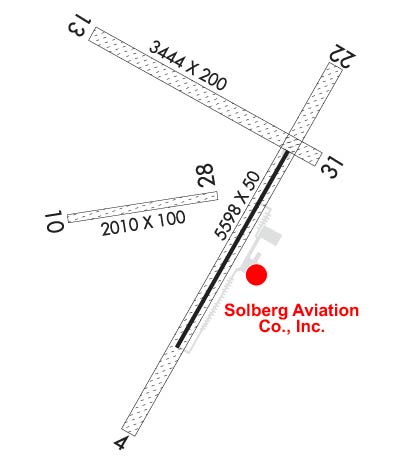 Airport Diagram might not be current. | |
| Facility Name: | SOLBERG-HUNTERDON |
| City Name: | READINGTON |
| County: | HUNTERDON |
| State abbrev: | NJ |
| State Name: | NEW JERSEY |
| Ownership: | PRIVATELY OWNED |
| Use: | OPEN TO THE PUBLIC |
| Owner's Name: | SOLBERG AVIATION COMPANY |
| Address: | PO BOX 15 |
| READINGTON, NJ 08870 | |
| Owner's Phone: | 908-534-4000 |
| Manager's Name: | THOR SOLBERG III; CO-MGRS: SUZANNE NAGLE AND LORRAINE SOLBERG |
| Address: | PO BOX 15 |
| READINGTON, NJ 08870 | |
| Phone: | 908-534-4000 |
| FAA Region: | EASTERN |
| FAA Field Office: | HAR |
| Date | Sunrise | Sunset |
|---|---|---|
| 09/24/21 Friday | 6:48 | 18:53 |
| 09/25/21 Saturday | 6:49 | 18:51 |
| 09/26/21 Sunday | 6:50 | 18:50 |
| 09/27/21 Monday | 6:51 | 18:48 |
| 09/28/21 Tuesday | 6:52 | 18:46 |
| 09/29/21 Wednesday | 6:53 | 18:45 |
| 09/30/21 Thursday | 6:54 | 18:43 |
| 10/01/21 Friday | 6:55 | 18:41 |
| 10/02/21 Saturday | 6:56 | 18:40 |
| 10/03/21 Sunday | 6:57 | 18:38 |
| 10/04/21 Monday | 6:58 | 18:37 |
| 10/05/21 Tuesday | 6:59 | 18:35 |
| 10/06/21 Wednesday | 7:00 | 18:33 |
| 10/07/21 Thursday | 7:01 | 18:32 |
| Airport Attendance Schedule | 7 Days A Week 0900-1700; ARPT UNATNDD ALL MAJOR HOLIDAYS & CHRISTMAS & NEW YEARS EVE AFTERNOONS. |
| Airport Status | OPERATIONAL (This Status can change at any time - please check NOTAMS) |
| Airport Lighting Schedule | SS-SR |
| Airport Storage Available | Tie Downs, Hanger |
| Extra Services Available | Flight Instruction, Aircraft Rental, Aircraft Sales |
| Wind Indicator | YES - (unlit) |
| Control Tower | NO |
| CTAF Frequency | 122.800 |
| Unicom Frequency | 122.800 |
| Rotating Beacon Color | |
| Segmented Circle | NO |
| Landing Fee | NO |
| Airport Inspected | STATE - performed by STATE AERONAUTICAL PERSONNEL |
| Inspection Date | 08/11/2020 |
| Type of Fuel Available | Grade 100LL, JET A (freeze point -40C) |
| Airframe Repair Service | MAJOR |
| Power Plant Repair Service | MAJOR |
| Latitude | N4035.0 |
| Longitude | W07444.2 (ESTIMATED) |
| Arpt Elevation | 189ft (ESTIMATED) |
| Magnetic Variation | 10W |
| 1 miles NW | of READINGTON |
| Traffic Pattern Altitude | TPA 1200 FT MSL FOR PISTON ACFT & 1700 FT MSL FOR JET ACFT. |
| Sectional Chart | NEW YORK |
| Operations (Reported) | Yearly | Avg. Daily |
|---|---|---|
| General Aviation Transient | 7520 | 21 |
| General Aviation Local | 13966 | 38 |
| Air Taxi | 0 | 0 |
| Commerical | 0 | 0 |
| Commuter | 0 | 0 |
| Military | 0 | 0 |
| Aircraft based on Field | |
|---|---|
| General Aviation Singles | 34 |
| General Aviation Multi | 4 |
| Jet Aircraft | 0 |
| General Aviation Helicopters | 1 |
| Military Aircraft | 0 |
| Gliders | 2 |
| Ultralights | 0 |
| FSS on field | NO |
| FSS tie-in | MILLVILLE |
| FSS Phone | 1-800-WX-BRIEF |
| Who issues Notams | MIV |
| Notam D service at airport | YES |
| ARTCC Name | NEW YORK |
| Airport Certification | |
| Aircraft Rescue & Firefighting Index | None |
| Airport of Entry | No |
| Custom Landing Rights | No |
| Joint Civil/Military | No |
| Military Landing rights | No |
| NATIONAL PLAN OF INTEGRATED AIRPORT SYSTEMS (NPIAS) |
| NO TGL ALL RWYS. |
| ALL RWYS DEPT STRAIGHT OUT TO 1200 FT MSL BEFORE TURNING. |
| BLIMP AND HOT AIR BALLOON ACTIVITY ON AND INVOF ARPT SPRING THRU FALL. |
| GCO AVBL ON FREQ 121.725 IF UNABLE, CTC NY APCH AT 800-645-3206. |
| DEER ON AND INVOF ARPT. |
| TKOFS AND LNDGS PROHIBITED ON RWY 4 WHEN ACTF ARE OPERATING ON RWY 13/31 AND RWY 10/28. |
| CTC OPS, 908-534-4000, PRIOR TO OPERATING ON RWY 10/28. |
| RWY 04/2 2 RWY 04/22 MIRL ON PAVED 3000 FT BY 50 FT PORTION OF RWY. |
Airport Communications & Frequencies:
| ||||||||||||||
| Runway: 04 | Runway: 22 | ||
| Mag heading: | 39° | Mag heading: | 219° |
| Rwy Slope: | -.66% Down | Rwy Slope: | .66% Up |
| Approach: | Approach: | ||
| Pattern: | Left Traffic | Pattern: | Left Traffic |
| Markings: | BASIC | Markings: | NONPRECISION INSTRUMENT |
| Marking Condition: | GOOD | Marking Condition: | GOOD |
| Arresting Dev: | Arresting Dev: | ||
| Lat & Long: | N4034.4 W07444.4 | Lat. & Long.: | N4035.2 W07443.8 |
| Elev: | 187.0 ft. MSL | Elev: | 150.0 ft. MSL |
| TCH: | TCH: | ||
| Visual Glide Path: | Visual Glide Path: | ||
| Displaced Threshold: | 1301 feet; DSPLCD THLD 1301 FT TURF 180 FT WIDE. | Displaced Threshold: | 1300 feet; DSPLCD THLD 1300 FT TURF 180 FT WIDE. |
| Touchdown Zone: | YES | Touchdown Zone: | YES |
| Touchdown Elev.: | 189.0 feet | Touchdown Elev.: | 189.0 feet |
| Visual Glide Slope: | Visual Glide Slope: | ||
| RVR Equipment: | RVR Equipment: | ||
| RVV Equipment: | NO | RVV Equipment: | NO |
| Approach Lights: | Approach Lights: | ||
| REIL: | NO | REIL: | NO |
| Centerline Lights: | NO | Centerline Lights: | NO |
| Touchdown lights: | NO | Touchdown lights: | NO |
| Runway Category: | Runway with a Non-precision Approach | Runway Category: | Runway with a Non-precision Approach |
| Declared Distances: | Declared Distances: | ||
| Obstructions: | Obstructions: | TREE | |
| Marked: | Marked: | NOT Marked/Lighted | |
| Clearance slope: | 50:1 | Clearance slope: | 22:1 |
| Obstruction height: | Obstruction height: | 66 feet AGL | |
| Dist. from runway: | Dist. from runway: | 1655 feet | |
| Centerline offset: | Centerline offset: | 150 feet right of centerline | |
| Comments: | Comments: |
| Runway: 10 | Runway: 28 | ||
| Mag heading: | 91° | Mag heading: | 271° |
| Rwy Slope: | -.41% Down | Rwy Slope: | .41% Up |
| Approach: | Approach: | ||
| Pattern: | Left Traffic | Pattern: | Left Traffic |
| Markings: | Markings: | ||
| Marking Condition: | POOR | Marking Condition: | POOR |
| Arresting Dev: | Arresting Dev: | ||
| Lat & Long: | N4034.9 W07444.6 | Lat. & Long.: | N4035.0 W07444.2 |
| Elev: | 186.2 ft. MSL | Elev: | 178.0 ft. MSL |
| TCH: | TCH: | ||
| Visual Glide Path: | Visual Glide Path: | ||
| Displaced Threshold: | No | Displaced Threshold: | No |
| Touchdown Zone: | YES | Touchdown Zone: | YES |
| Touchdown Elev.: | 186.2 feet | Touchdown Elev.: | 186.2 feet |
| Visual Glide Slope: | Visual Glide Slope: | ||
| RVR Equipment: | RVR Equipment: | ||
| RVV Equipment: | NO | RVV Equipment: | NO |
| Approach Lights: | Approach Lights: | ||
| REIL: | NO | REIL: | NO |
| Centerline Lights: | NO | Centerline Lights: | NO |
| Touchdown lights: | NO | Touchdown lights: | NO |
| Runway Category: | Runway with a Visual Approach | Runway Category: | Runway with a Visual Approach |
| Declared Distances: | Declared Distances: | ||
| Obstructions: | TREES | Obstructions: | |
| Marked: | MARKED | Marked: | |
| Clearance slope: | 6:1 | Clearance slope: | |
| Obstruction height: | 58 feet AGL | Obstruction height: | |
| Dist. from runway: | 602 feet | Dist. from runway: | |
| Centerline offset: | 81 right of centerline | Centerline offset: | |
| Comments: | Comments: |
| Runway: 13 | Runway: 31 | ||
| Mag heading: | 129° | Mag heading: | 309° |
| Rwy Slope: | -1.01% Down | Rwy Slope: | 1.01% Up |
| Approach: | Approach: | ||
| Pattern: | Left Traffic | Pattern: | Left Traffic |
| Markings: | Markings: | ||
| Marking Condition: | GOOD | Marking Condition: | GOOD |
| Arresting Dev: | Arresting Dev: | ||
| Lat & Long: | N4035.3 W07444.5 | Lat. & Long.: | N4035.0 W07443.9 |
| Elev: | 186.9 ft. MSL | Elev: | 152.1 ft. MSL |
| TCH: | TCH: | ||
| Visual Glide Path: | Visual Glide Path: | ||
| Displaced Threshold: | No | Displaced Threshold: | No |
| Touchdown Zone: | YES | Touchdown Zone: | YES |
| Touchdown Elev.: | 186.9 feet | Touchdown Elev.: | 186.9 feet |
| Visual Glide Slope: | Visual Glide Slope: | ||
| RVR Equipment: | RVR Equipment: | ||
| RVV Equipment: | NO | RVV Equipment: | NO |
| Approach Lights: | Approach Lights: | ||
| REIL: | NO | REIL: | NO |
| Centerline Lights: | NO | Centerline Lights: | NO |
| Touchdown lights: | NO | Touchdown lights: | NO |
| Runway Category: | Runway with a Visual Approach | Runway Category: | Runway with a Visual Approach |
| Declared Distances: | Declared Distances: | ||
| Obstructions: | TREE | Obstructions: | TREES |
| Marked: | NOT Marked/Lighted | Marked: | NOT Marked/Lighted |
| Clearance slope: | 2:1 | Clearance slope: | 1:1 |
| Obstruction height: | 40 feet AGL | Obstruction height: | 44 feet AGL |
| Dist. from runway: | 108 feet | Dist. from runway: | 48 feet |
| Centerline offset: | 99 left of centerline | Centerline offset: | |
| Comments: | Comments: |
Thanks for using FltPlan.com
all rights reserved © 1999-2021 by Flight Plan LLC


