| BRADFORD COUNTY TOWANDA PA |
| |
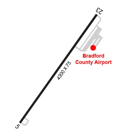
| Lat: N 4144.4 Long: W 07626.8 Elev: 730 Var: +12 Longest Runway: 4301 | ||
| AWOS: 119.92 CTAF: 123.0 | ||
| |||||||||||||||||||||||||||||||||||||||||||||||||||||||||||||
| |||||||||||||||||||||||||||||||||||||||||||||||||||||||||||||
| |||||||||||||||||||||||||||||||||||||||||||||||||||||||||||||
| Rwy | Rwy | |||||||
| 4301x75 | 4301' | 4301x75 | 4301' | |||||
| Runway ID | Single Wheel | Double Wheel | Double Tandem Wheel | Dual Double Wheel |
| 05/23 | 12,000 | N/A | N/A | N/A |
| These numbers are Advisory and are not limits. The Airport Manager should have more accurate Weight Limits | ||||
 Airport Diagram might not be current. | |
| Facility Name: | BRADFORD COUNTY |
| City Name: | TOWANDA |
| County: | BRADFORD |
| State abbrev: | PA |
| State Name: | PENNSYLVANIA |
| Ownership: | PUBLICLY OWNED |
| Use: | OPEN TO THE PUBLIC |
| Owner's Name: | BRADFORD COUNTY AIRPORT AUTHORITY |
| Address: | 415 AIRPORT RD. |
| TOWANDA, PA 18848 | |
| Owner's Phone: | 570-265-4900 |
| Manager's Name: | SCOTT HAUSER |
| Address: | 415 AIRPORT RD. |
| TOWANDA, PA 18848 | |
| Phone: | 570-265-4900 |
| FAA Region: | EASTERN |
| FAA Field Office: | HAR |
| Date | Sunrise | Sunset |
|---|---|---|
| 06/08/26 Monday | 5:31 | 20:39 |
| 06/09/26 Tuesday | 5:31 | 20:39 |
| 06/10/26 Wednesday | 5:31 | 20:40 |
| 06/11/26 Thursday | 5:31 | 20:40 |
| 06/12/26 Friday | 5:31 | 20:41 |
| 06/13/26 Saturday | 5:30 | 20:41 |
| 06/14/26 Sunday | 5:30 | 20:42 |
| 06/15/26 Monday | 5:30 | 20:42 |
| 06/16/26 Tuesday | 5:30 | 20:42 |
| 06/17/26 Wednesday | 5:31 | 20:43 |
| 06/18/26 Thursday | 5:31 | 20:43 |
| 06/19/26 Friday | 5:31 | 20:43 |
| 06/20/26 Saturday | 5:31 | 20:44 |
| 06/21/26 Sunday | 5:31 | 20:44 |
| Airport Attendance Schedule | M-F 0800-1700, MAR-OCT SAT-SUN 0800-1600, NOV-FEB SAT-SUN UNATTENDED; FOR SVC AFT HRS CALL 570-637-4902. |
| Airport Status | OPERATIONAL (This Status can change at any time - please check NOTAMS) |
| Airport Lighting Schedule | ACTVT REIL RWY 05 & 23; PAPI RWY 05 & 23; MIRL RWY 05/23 - CTAF. |
| Airport Storage Available | Tie Downs, Hanger |
| Extra Services Available | Flight Instruction |
| Wind Indicator | YES - (lighted) |
| Control Tower | NO |
| CTAF Frequency | 123.000 |
| Unicom Frequency | 123.000 |
| Rotating Beacon Color | WG |
| Segmented Circle | YES |
| Landing Fee | NO |
| Airport Inspected | STATE - performed by STATE AERONAUTICAL PERSONNEL |
| Inspection Date | 11/19/2025 |
| Type of Fuel Available | Grade 100LL, JET A (freeze point -40C) |
| Airframe Repair Service | MAJOR |
| Power Plant Repair Service | MAJOR |
| Latitude | N4144.4 |
| Longitude | W07626.8 (ESTIMATED) |
| Arpt Elevation | 730ft (SURVEYED) |
| Magnetic Variation | 12W |
| 2 miles S | of TOWANDA |
| Traffic Pattern Altitude | |
| Sectional Chart | NEW YORK |
| Operations (Reported) | Yearly | Avg. Daily |
|---|---|---|
| General Aviation Transient | 0 | 0 |
| General Aviation Local | 0 | 0 |
| Air Taxi | 0 | 0 |
| Commerical | 0 | 0 |
| Commuter | 0 | 0 |
| Military | 0 | 0 |
| Aircraft based on Field | |
|---|---|
| General Aviation Singles | 0 |
| General Aviation Multi | 0 |
| Jet Aircraft | 0 |
| General Aviation Helicopters | 0 |
| Military Aircraft | 0 |
| Gliders | 0 |
| Ultralights | 0 |
| FSS on field | NO |
| FSS tie-in | WILLIAMSPORT |
| FSS Phone | 1-800-WX-BRIEF |
| Who issues Notams | IPT |
| Notam D service at airport | YES |
| ARTCC Name | NEW YORK |
| Airport Certification | |
| Aircraft Rescue & Firefighting Index | None |
| Airport of Entry | No |
| Custom Landing Rights | No |
| Joint Civil/Military | No |
| Military Landing rights | YES |
| NATIONAL PLAN OF INTEGRATED AIRPORT SYSTEMS (NPIAS) |
| GRANT AGREEMENT HAS EXPIRED; HOWEVER, AGREEMENT REMAINS IN EFFECT FOR THIS FACILITY AS LONG AS IT IS PUBLIC USE. |
| FOR CD CTC BINGHAMTON APCH AT 607-729-6146. WHEN APCH CLSD, CTC NEW YORK ARTCC AT 631-468-1425. |
Airport Communications & Frequencies:
| |||||||||||||||||
| Runway: 05 | Runway: 23 | ||
| Mag heading: | 47° | Mag heading: | 227° |
| Rwy Slope: | -.39% Down | Rwy Slope: | .39% Up |
| Approach: | Approach: | ||
| Pattern: | Left Traffic | Pattern: | Left Traffic |
| Markings: | NONPRECISION INSTRUMENT | Markings: | NONPRECISION INSTRUMENT |
| Marking Condition: | GOOD | Marking Condition: | GOOD |
| Arresting Dev: | Arresting Dev: | ||
| Lat & Long: | N4144.1 W07627.1 | Lat. & Long.: | N4144.7 W07626.6 |
| Elev: | 730.2 ft. MSL | Elev: | 713.5 ft. MSL |
| TCH: | 37 ft. AGL | TCH: | 37 ft. AGL |
| Visual Glide Path: | 3.00 degrees | Visual Glide Path: | 3.00 degrees |
| Displaced Threshold: | No | Displaced Threshold: | No |
| Touchdown Zone: | YES | Touchdown Zone: | YES |
| Touchdown Elev.: | 730.3 feet | Touchdown Elev.: | 728.7 feet |
| Visual Glide Slope: | 2-Light PAPI on LEFT side of Runway | Visual Glide Slope: | 2-Light PAPI on LEFT side of Runway |
| RVR Equipment: | RVR Equipment: | ||
| RVV Equipment: | NO | RVV Equipment: | NO |
| Approach Lights: | Approach Lights: | ||
| REIL: | YES | REIL: | YES |
| Centerline Lights: | NO | Centerline Lights: | NO |
| Touchdown lights: | NO | Touchdown lights: | NO |
| Runway Category: | Runway with a Visual Approach | Runway Category: | Runway with a Non-precision Approach |
| Declared Distances: | Declared Distances: |
Thanks for using FltPlan.com
all rights reserved © 1999-2026 by Flight Plan LLC