
| LAKEWOOD LAKEWOOD NJ |
| |
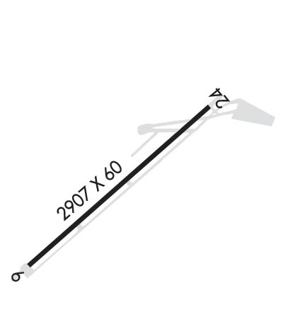
| Lat: N 4004.0 Long: W 07410.7 Elev: 42 Var: +13 Longest Runway: 2987 | ||
| AWOS: 122.8 CTAF: 122.8 | ||
| |||||||||||||||||||||||||||||||||||||||||||||||||||||||||||||
| |||||||||||||||||||||||||||||||||||||||||||||||||||||||||||||
| |||||||||||||||||||||||||||||||||||||||||||||||||||||||||||||
| Rwy | Rwy | |||||||
| 2987x60 | 2726' | 2987x60 | 2987' | |||||
| Runway ID | Single Wheel | Double Wheel | Double Tandem Wheel | Dual Double Wheel |
| 06/24 | 25,000 | N/A | N/A | N/A |
| These numbers are Advisory and are not limits. The Airport Manager should have more accurate Weight Limits | ||||
 Airport Diagram might not be current. | |
| Facility Name: | LAKEWOOD |
| City Name: | LAKEWOOD |
| County: | OCEAN |
| State abbrev: | NJ |
| State Name: | NEW JERSEY |
| Ownership: | PUBLICLY OWNED |
| Use: | OPEN TO THE PUBLIC |
| Owner's Name: | LAKEWOOD TOWNSHIP |
| Address: | 231 THIRD STREET |
| LAKEWOOD, NJ 08701 | |
| Owner's Phone: | 732-364-2500 |
| Manager's Name: | STEVE REINMAN |
| Address: | 231 THIRD STREET |
| LAKEWOOD, NJ 08701 | |
| Phone: | 732-363-6400; ALT 732-533-3062. |
| FAA Region: | EASTERN |
| FAA Field Office: | HAR |
| Date | Sunrise | Sunset |
|---|---|---|
| 06/08/26 Monday | 5:28 | 20:24 |
| 06/09/26 Tuesday | 5:27 | 20:25 |
| 06/10/26 Wednesday | 5:27 | 20:25 |
| 06/11/26 Thursday | 5:27 | 20:26 |
| 06/12/26 Friday | 5:27 | 20:26 |
| 06/13/26 Saturday | 5:27 | 20:27 |
| 06/14/26 Sunday | 5:27 | 20:27 |
| 06/15/26 Monday | 5:27 | 20:27 |
| 06/16/26 Tuesday | 5:27 | 20:28 |
| 06/17/26 Wednesday | 5:27 | 20:28 |
| 06/18/26 Thursday | 5:27 | 20:28 |
| 06/19/26 Friday | 5:27 | 20:29 |
| 06/20/26 Saturday | 5:28 | 20:29 |
| 06/21/26 Sunday | 5:28 | 20:29 |
| Airport Attendance Schedule | MAY-OCT 7 Days A Week 0800-2000, NOV-APR 7 Days A Week 0800-1800; SVCS AVBL AFT HRS CALL 732-533-3062. |
| Airport Status | OPERATIONAL (This Status can change at any time - please check NOTAMS) |
| Airport Lighting Schedule | ACTVT PAPI RWY 06 & 24; MIRL RWY 06/24 - CTAF. |
| Airport Storage Available | Tie Downs |
| Extra Services Available | Charter, Flight Instruction, Parachute Jumping, Aircraft Rental, Aircraft Sales |
| Wind Indicator | YES - (lighted) |
| Control Tower | NO |
| CTAF Frequency | 122.800 |
| Unicom Frequency | 122.800 |
| Rotating Beacon Color | WG |
| Segmented Circle | NO |
| Landing Fee | NO |
| Airport Inspected | STATE - performed by STATE AERONAUTICAL PERSONNEL |
| Inspection Date | 07/18/2025 |
| Type of Fuel Available | Grade 100LL |
| Airframe Repair Service | MAJOR |
| Power Plant Repair Service | MAJOR |
| Latitude | N4004.0 |
| Longitude | W07410.7 (ESTIMATED) |
| Arpt Elevation | 41ft (SURVEYED) |
| Magnetic Variation | 13W |
| 3 miles SE | of LAKEWOOD |
| Traffic Pattern Altitude | |
| Sectional Chart | NEW YORK |
| Operations (Reported) | Yearly | Avg. Daily |
|---|---|---|
| General Aviation Transient | 0 | 0 |
| General Aviation Local | 0 | 0 |
| Air Taxi | 0 | 0 |
| Commerical | 0 | 0 |
| Commuter | 0 | 0 |
| Military | 0 | 0 |
| Aircraft based on Field | |
|---|---|
| General Aviation Singles | 0 |
| General Aviation Multi | 0 |
| Jet Aircraft | 0 |
| General Aviation Helicopters | 0 |
| Military Aircraft | 0 |
| Gliders | 0 |
| Ultralights | 0 |
| FSS on field | NO |
| FSS tie-in | MILLVILLE |
| FSS Phone | 1-800-WX-BRIEF |
| Who issues Notams | MIV |
| Notam D service at airport | YES |
| ARTCC Name | NEW YORK |
| Airport Certification | |
| Aircraft Rescue & Firefighting Index | None |
| Airport of Entry | No |
| Custom Landing Rights | No |
| Joint Civil/Military | No |
| Military Landing rights | No |
| NATIONAL PLAN OF INTEGRATED AIRPORT SYSTEMS (NPIAS) |
| GCO AVBL ON FREQ 121.725 THRU MCGUIRE APCH CTL. IF UNAVBL CTC MC GUIRE APCH AT 609-754-2767. |
| HEAVY BANNER TOWING OPS APR-OCT. |
| DEER ON AND INVOF OF ARPT. |
| FOR CD USE GCO 121.725, IF UNA CTC MC GUIRE APCH AT 609-754-2767. |
Airport Communications & Frequencies:
| ||||||||||||||
| Runway: 06 | Runway: 24 | ||
| Mag heading: | 60° | Mag heading: | 240° |
| Rwy Slope: | -.26% Down | Rwy Slope: | .26% Up |
| Approach: | Approach: | ||
| Pattern: | Left Traffic | Pattern: | Right Traffic |
| Markings: | NONPRECISION INSTRUMENT | Markings: | NONPRECISION INSTRUMENT |
| Marking Condition: | GOOD | Marking Condition: | GOOD |
| Arresting Dev: | Arresting Dev: | ||
| Lat & Long: | N4003.8 W07410.9 | Lat. & Long.: | N4004.2 W07410.4 |
| Elev: | 41.0 ft. MSL | Elev: | 33.1 ft. MSL |
| TCH: | 15 ft. AGL | TCH: | 42 ft. AGL |
| Visual Glide Path: | 3.00 degrees | Visual Glide Path: | 3.00 degrees |
| Displaced Threshold: | 261 feet | Displaced Threshold: | No |
| Touchdown Zone: | YES | Touchdown Zone: | YES |
| Touchdown Elev.: | 41.4 feet | Touchdown Elev.: | 41.9 feet |
| Visual Glide Slope: | 2-Light PAPI on RIGHT side of Runway | Visual Glide Slope: | 2-Light PAPI on LEFT side of Runway |
| RVR Equipment: | RVR Equipment: | ||
| RVV Equipment: | NO | RVV Equipment: | NO |
| Approach Lights: | Approach Lights: | ||
| REIL: | YES | REIL: | YES |
| Centerline Lights: | NO | Centerline Lights: | NO |
| Touchdown lights: | NO | Touchdown lights: | NO |
| Runway Category: | Runway with a Non-precision Approach | Runway Category: | Runway with a Non-precision Approach |
| Declared Distances: | Declared Distances: | ||
| Obstructions: | TREES | Obstructions: | ROAD |
| Marked: | NOT Marked/Lighted | Marked: | NOT Marked/Lighted |
| Clearance slope: | 5:1; RY 06 HAS APCH RATIO 52:1 TO DSPLCD THLD. | Clearance slope: | |
| Obstruction height: | 10 feet AGL | Obstruction height: | 10 feet AGL |
| Dist. from runway: | 258 feet | Dist. from runway: | 200 feet |
| Centerline offset: | 134 left of centerline | Centerline offset: | 60 feet right of centerline |
| Comments: | Comments: | RY 24 10 FT ROAD AT RY END 120 FT R CNTRLN. |
Thanks for using FltPlan.com
all rights reserved © 1999-2026 by Flight Plan LLC

