
| CORTLAND COUNTY-CHASE FIELD CORTLAND NY |
| |
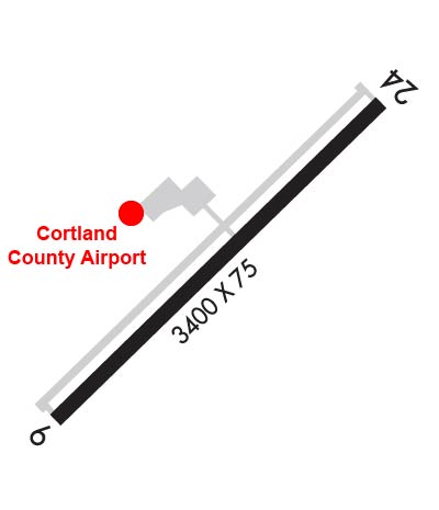
| Lat: N 4235.6 Long: W 07612.9 Elev: 1197 Var: +13 Longest Runway: 3401 | ||
| AWOS: 132.22 CTAF: 122.8 | ||
| |||||||||||||||||||||||||||||||||||||||||||||||||||||||||||||
| |||||||||||||||||||||||||||||||||||||||||||||||||||||||||||||
| |||||||||||||||||||||||||||||||||||||||||||||||||||||||||||||
| Rwy | Rwy | |||||||
| 3401x75 | 3401' | 3401x75 | 3401' | |||||
| Runway ID | Single Wheel | Double Wheel | Double Tandem Wheel | Dual Double Wheel |
| 06/24 | 12,000 | N/A | N/A | N/A |
| These numbers are Advisory and are not limits. The Airport Manager should have more accurate Weight Limits | ||||
 Airport Diagram might not be current. | |
| Facility Name: | CORTLAND COUNTY/CHASE FLD |
| City Name: | CORTLAND |
| County: | CORTLAND |
| State abbrev: | NY |
| State Name: | NEW YORK |
| Ownership: | PUBLICLY OWNED |
| Use: | OPEN TO THE PUBLIC |
| Owner's Name: | CORTLAND COUNTY |
| Address: | 60 CENTRAL AVE. |
| CORTLAND, NY 13045 | |
| Owner's Phone: | 607-753-9377 |
| Manager's Name: | MATT WETHERELL |
| Address: | 60 CENTRAL AVE. |
| CORTLAND, NY 13045 | |
| Phone: | 607-745-5872 |
| FAA Region: | EASTERN |
| FAA Field Office: | NYC |

| Date | Sunrise | Sunset |
|---|---|---|
| 06/08/26 Monday | 5:27 | 20:41 |
| 06/09/26 Tuesday | 5:27 | 20:41 |
| 06/10/26 Wednesday | 5:27 | 20:42 |
| 06/11/26 Thursday | 5:27 | 20:42 |
| 06/12/26 Friday | 5:27 | 20:43 |
| 06/13/26 Saturday | 5:27 | 20:43 |
| 06/14/26 Sunday | 5:27 | 20:44 |
| 06/15/26 Monday | 5:27 | 20:44 |
| 06/16/26 Tuesday | 5:27 | 20:45 |
| 06/17/26 Wednesday | 5:27 | 20:45 |
| 06/18/26 Thursday | 5:27 | 20:45 |
| 06/19/26 Friday | 5:27 | 20:46 |
| 06/20/26 Saturday | 5:27 | 20:46 |
| 06/21/26 Sunday | 5:27 | 20:46 |
| Airport Attendance Schedule | MON-FRI 0700-1530; UNATNDD HOLIDAYS, OTR HRS CALL ARPT MGR. |
| Airport Status | OPERATIONAL (This Status can change at any time - please check NOTAMS) |
| Airport Lighting Schedule | ACTVT REIL RWY 24; PAPI RWY 06 & 24; MIRL RWY 06/24; TWY LGTS - CTAF. |
| Airport Storage Available | Tie Downs, Hanger |
| Extra Services Available | Flight Instruction, Aircraft Rental |
| Wind Indicator | YES - (lighted) |
| Control Tower | NO |
| CTAF Frequency | 122.800 |
| Unicom Frequency | 122.800 |
| Rotating Beacon Color | WG |
| Segmented Circle | YES |
| Landing Fee | NO |
| Airport Inspected | STATE - performed by STATE AERONAUTICAL PERSONNEL |
| Inspection Date | 08/12/2024 |
| Type of Fuel Available | Grade 100LL, JET A; -10SELF SVC AVBL 24 HRS WITH CREDIT CARD.; -A+SELF SVC AVBL 24 HRS WITH CREDIT CARD. |
| Airframe Repair Service | MAJOR |
| Power Plant Repair Service | MAJOR |
| Latitude | N4235.6 |
| Longitude | W07612.9 (ESTIMATED) |
| Arpt Elevation | 1197ft (SURVEYED) |
| Magnetic Variation | 13W |
| 2 miles SW | of CORTLAND |
| Traffic Pattern Altitude | |
| Sectional Chart | NEW YORK |
| Operations (Reported) | Yearly | Avg. Daily |
|---|---|---|
| General Aviation Transient | 0 | 0 |
| General Aviation Local | 0 | 0 |
| Air Taxi | 0 | 0 |
| Commerical | 0 | 0 |
| Commuter | 0 | 0 |
| Military | 0 | 0 |
| Aircraft based on Field | |
|---|---|
| General Aviation Singles | 0 |
| General Aviation Multi | 0 |
| Jet Aircraft | 0 |
| General Aviation Helicopters | 0 |
| Military Aircraft | 0 |
| Gliders | 0 |
| Ultralights | 0 |
| FSS on field | NO |
| FSS tie-in | BUFFALO |
| FSS Phone | 1-800-WX-BRIEF |
| Who issues Notams | N03 |
| Notam D service at airport | YES |
| ARTCC Name | NEW YORK |
| Airport Certification | |
| Aircraft Rescue & Firefighting Index | None |
| Airport of Entry | No |
| Custom Landing Rights | No |
| Joint Civil/Military | No |
| Military Landing rights | YES |
| NATIONAL PLAN OF INTEGRATED AIRPORT SYSTEMS (NPIAS) |
| GRANT AGREEMENTS UNDER FAAP/ADAP/AIP |
| ASSURANCES PURSUANT TO TITLE VI, CIVIL RIGHTS ACT OF 1964 |
| SNOW REMOVAL DRG DAY ONLY. |
| HVY CONCENTRATION OF GEESE AND GULLS ON AND INVOF ARPT DRG SPRING/FALL. |
| FOR CD CTC SYRACUSE APCH AT 315-455-6218. |
Airport Communications & Frequencies:
| |||||||||||||||||||||||||||
| Runway: 06 | Runway: 24 | ||
| Mag heading: | 59° | Mag heading: | 239° |
| Rwy Slope: | -.98% Down | Rwy Slope: | .98% Up |
| Approach: | Approach: | ||
| Pattern: | Left Traffic | Pattern: | Left Traffic |
| Markings: | NONPRECISION INSTRUMENT | Markings: | NONPRECISION INSTRUMENT |
| Marking Condition: | GOOD | Marking Condition: | GOOD |
| Arresting Dev: | Arresting Dev: | ||
| Lat & Long: | N4235.4 W07613.2 | Lat. & Long.: | N4235.8 W07612.6 |
| Elev: | 1197.3 ft. MSL | Elev: | 1163.9 ft. MSL |
| TCH: | 40 ft. AGL | TCH: | 45 ft. AGL |
| Visual Glide Path: | 4.00 degrees | Visual Glide Path: | 4.00 degrees |
| Displaced Threshold: | No | Displaced Threshold: | No |
| Touchdown Zone: | YES | Touchdown Zone: | YES |
| Touchdown Elev.: | 1197.3 feet | Touchdown Elev.: | 1191.6 feet |
| Visual Glide Slope: | 2-Light PAPI on LEFT side of Runway | Visual Glide Slope: | 2-Light PAPI on LEFT side of Runway |
| RVR Equipment: | RVR Equipment: | ||
| RVV Equipment: | NO | RVV Equipment: | NO |
| Approach Lights: | Approach Lights: | ||
| REIL: | NO | REIL: | YES |
| Centerline Lights: | NO | Centerline Lights: | NO |
| Touchdown lights: | NO | Touchdown lights: | NO |
| Runway Category: | Runway with a Non-precision Approach | Runway Category: | Runway with a Non-precision Approach |
| Declared Distances: | Declared Distances: | ||
| Obstructions: | POLE | Obstructions: | TREES |
| Marked: | NOT Marked/Lighted | Marked: | NOT Marked/Lighted |
| Clearance slope: | 8:1 | Clearance slope: | 20:1 |
| Obstruction height: | 36 feet AGL | Obstruction height: | 23 feet AGL |
| Dist. from runway: | 515 feet | Dist. from runway: | 665 feet |
| Centerline offset: | 294 left of centerline | Centerline offset: | 178 feet left of centerline |
| Comments: | Comments: |
Thanks for using FltPlan.com
all rights reserved © 1999-2026 by Flight Plan LLC
