
| MARION MUNI MARION IN |
| |
| Lat: N 4029.4 Long: W 08540.8 Elev: 859 Var: +03 Longest Runway: 6011 | ||
| Clr Del: 120.0 AWOS: 108.6 CTAF: 122.7 | ||
| ||||||
| ||||||
|
| Rwy | Rwy | |||||||
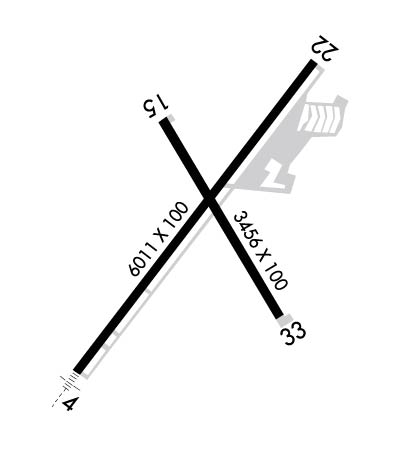
| 6011x100 | 6011' | 111.70 - 041° | 6011x100 | 6011' | ||||
| 3456x100 | 3456' | 3456x100 | 3456' | |||||
| Runway ID | Single Wheel | Double Wheel | Double Tandem Wheel | Dual Double Wheel |
| 04/22 | 60,000 | 90,000 | 70,000 | N/A |
| 15/33 | 22,000 | 32,000 | N/A | N/A |
| These numbers are Advisory and are not limits. The Airport Manager should have more accurate Weight Limits | ||||
 Airport Diagram might not be current. | |
| Facility Name: | MARION MUNI - MCKINNEY FLD |
| City Name: | MARION |
| County: | GRANT |
| State abbrev: | IN |
| State Name: | INDIANA |
| Ownership: | PUBLICLY OWNED |
| Use: | OPEN TO THE PUBLIC |
| Owner's Name: | CITY OF MARION BOAC |
| Address: | 5904 S WESTERN AVE |
| MARION, IN 46953 | |
| Owner's Phone: | 765-674-7777 |
| Manager's Name: | ANDY DARLINGTON |
| Address: | 5904 S WESTERN AVE |
| MARION, IN 46953 | |
| Phone: | 765-674-7777 |
| FAA Region: | GREAT LAKES |
| FAA Field Office: | CHI |
| Date | Sunrise | Sunset |
|---|---|---|
| 09/24/21 Friday | 7:32 | 19:37 |
| 09/25/21 Saturday | 7:33 | 19:35 |
| 09/26/21 Sunday | 7:34 | 19:34 |
| 09/27/21 Monday | 7:35 | 19:32 |
| 09/28/21 Tuesday | 7:36 | 19:30 |
| 09/29/21 Wednesday | 7:37 | 19:29 |
| 09/30/21 Thursday | 7:38 | 19:27 |
| 10/01/21 Friday | 7:39 | 19:25 |
| 10/02/21 Saturday | 7:40 | 19:24 |
| 10/03/21 Sunday | 7:41 | 19:22 |
| 10/04/21 Monday | 7:42 | 19:20 |
| 10/05/21 Tuesday | 7:43 | 19:19 |
| 10/06/21 Wednesday | 7:44 | 19:17 |
| 10/07/21 Thursday | 7:45 | 19:15 |
| Airport Attendance Schedule | MON-FRI 0700-1800, SAT 0800-1700, SUN 0800-1700; UNATNDD CHRISTMAS DAY. |
| Airport Status | OPERATIONAL (This Status can change at any time - please check NOTAMS) |
| Airport Lighting Schedule | ACTVT MALSR RWY 04; REIL RWY 15, 22 & 33 - CTAF. PAPI RWY 15 & 33 ON DURG DAY; ACTVT AT NIGHT- CTAF. HIRL RWY 04/22; MIRL RWY 15/33 PRESET LOW INTST; INCR INTST - CTAF. |
| Airport Storage Available | Tie Downs, Hanger |
| Extra Services Available | Flight Instruction, Aircraft Rental |
| Wind Indicator | YES - (lighted) |
| Control Tower | NO |
| CTAF Frequency | 122.700 |
| Unicom Frequency | 122.700 |
| Rotating Beacon Color | CLEAR-GREEN (Light Land Airport) |
| Segmented Circle | YES |
| Landing Fee | NO |
| Airport Inspected | STATE - performed by STATE AERONAUTICAL PERSONNEL |
| Inspection Date | 09/12/2018 |
| Type of Fuel Available | Grade 100LL, JET A (freeze point -40C); -10SELF SVC AVBL. |
| Airframe Repair Service | MAJOR |
| Power Plant Repair Service | MAJOR |
| Latitude | N4029.4 |
| Longitude | W08540.8 (ESTIMATED) |
| Arpt Elevation | 858ft (SURVEYED) |
| Magnetic Variation | 03W |
| 3 miles SW | of MARION |
| Traffic Pattern Altitude | |
| Sectional Chart | CHICAGO |
| Operations (Reported) | Yearly | Avg. Daily |
|---|---|---|
| General Aviation Transient | 2925 | 8 |
| General Aviation Local | 4550 | 12 |
| Air Taxi | 569 | 2 |
| Commerical | 0 | 0 |
| Commuter | 0 | 0 |
| Military | 81 | 0 |
| Aircraft based on Field | |
|---|---|
| General Aviation Singles | 32 |
| General Aviation Multi | 2 |
| Jet Aircraft | 2 |
| General Aviation Helicopters | 2 |
| Military Aircraft | 0 |
| Gliders | 0 |
| Ultralights | 0 |
| FSS on field | NO |
| FSS tie-in | TERRE HAUTE |
| FSS Phone | 1-800-WX-BRIEF |
| Who issues Notams | HUF |
| Notam D service at airport | YES |
| ARTCC Name | CHICAGO |
| Airport Certification | |
| Aircraft Rescue & Firefighting Index | None |
| Airport of Entry | No |
| Custom Landing Rights | No |
| Joint Civil/Military | No |
| Military Landing rights | YES |
| NATIONAL PLAN OF INTEGRATED AIRPORT SYSTEMS (NPIAS) |
| GRANT AGREEMENTS UNDER FAAP/ADAP/AIP |
| ASSURANCES PURSUANT TO TITLE VI, CIVIL RIGHTS ACT OF 1964 |
| FOR CD CTC CHICAGO ARTCC AT 630-906-8921. |
| RWY 33 -12 FT DITCH 200 FT L OF CNTRLN; 8 - 10 FT GND 230 FT L OF CNTRLN PARL S HALF OF RWY. |
Airport Communications & Frequencies:
| |||||||||||||||||||
| Runway: 04 | Runway: 22 | ||
| Mag heading: | 40° | Mag heading: | 220° |
| Rwy Slope: | -.13% Down | Rwy Slope: | .13% Up |
| Approach: | ILS | Approach: | |
| Pattern: | Left Traffic | Pattern: | Left Traffic |
| Markings: | PRECISION INSTRUMENT | Markings: | NONPRECISION INSTRUMENT |
| Marking Condition: | GOOD | Marking Condition: | GOOD |
| Arresting Dev: | Arresting Dev: | ||
| Lat & Long: | N4029.0 W08541.2 | Lat. & Long.: | N4029.8 W08540.4 |
| Elev: | 858.1 ft. MSL | Elev: | 850.0 ft. MSL |
| TCH: | TCH: | ||
| Visual Glide Path: | Visual Glide Path: | ||
| Displaced Threshold: | No | Displaced Threshold: | No |
| Touchdown Zone: | YES | Touchdown Zone: | YES |
| Touchdown Elev.: | 858.3 feet | Touchdown Elev.: | 858.7 feet |
| Visual Glide Slope: | Visual Glide Slope: | ||
| RVR Equipment: | RVR Equipment: | ||
| RVV Equipment: | NO | RVV Equipment: | NO |
| Approach Lights: | MALSR - 1,400 foot medium intensity approach lighting system with runway alignment indicator lights | Approach Lights: | |
| REIL: | NO | REIL: | YES |
| Centerline Lights: | NO | Centerline Lights: | NO |
| Touchdown lights: | NO | Touchdown lights: | NO |
| Runway Category: | Precision Instrument Runway | Runway Category: | Runway with a Non-precision Approach having visibility minimums greater than 3/4 mile |
| Declared Distances: | Declared Distances: | ||
| Comments: | Comments: | CROPS 285 R & 315 L OF CNTRLN. |
| Runway: 15 | Runway: 33 | ||
| Mag heading: | 153° | Mag heading: | 333° |
| Rwy Slope: | -.23% Down | Rwy Slope: | .23% Up |
| Approach: | Approach: | ||
| Pattern: | Left Traffic | Pattern: | Left Traffic |
| Markings: | BASIC | Markings: | BASIC |
| Marking Condition: | GOOD | Marking Condition: | GOOD |
| Arresting Dev: | Arresting Dev: | ||
| Lat & Long: | N4029.6 W08540.9 | Lat. & Long.: | N4029.1 W08540.5 |
| Elev: | 857.5 ft. MSL | Elev: | 849.5 ft. MSL |
| TCH: | 40 ft. AGL | TCH: | 38 ft. AGL |
| Visual Glide Path: | 3.25 degrees | Visual Glide Path: | 4.00 degrees |
| Displaced Threshold: | No | Displaced Threshold: | No |
| Touchdown Zone: | YES | Touchdown Zone: | YES |
| Touchdown Elev.: | 858.7 feet | Touchdown Elev.: | 858.7 feet |
| Visual Glide Slope: | 2-Light PAPI on LEFT side of Runway | Visual Glide Slope: | 2-Light PAPI on LEFT side of Runway; PAPI UNUSBL BYD 9 DEGS LEFT OF CNTRLN. |
| RVR Equipment: | RVR Equipment: | ||
| RVV Equipment: | NO | RVV Equipment: | NO |
| Approach Lights: | Approach Lights: | ||
| REIL: | YES | REIL: | YES |
| Centerline Lights: | NO | Centerline Lights: | NO |
| Touchdown lights: | NO | Touchdown lights: | NO |
| Runway Category: | Runway with a Non-precision Approach | Runway Category: | Runway with a Non-precision Approach |
| Declared Distances: | Declared Distances: | ||
| Obstructions: | TREES | Obstructions: | |
| Marked: | NOT Marked/Lighted | Marked: | |
| Clearance slope: | 15:1 | Clearance slope: | 20:1 |
| Obstruction height: | 80 feet AGL | Obstruction height: | |
| Dist. from runway: | 1400 feet | Dist. from runway: | |
| Centerline offset: | 250 right of centerline | Centerline offset: | |
| Comments: | Comments: |
Thanks for using FltPlan.com
all rights reserved © 1999-2021 by Flight Plan LLC
