
| PINAL AIRPARK MARANA AZ |
| |
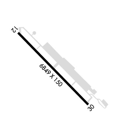
| Lat: N 3230.6 Long: W 11119.5 Elev: 1893 Var: -12 Longest Runway: 6849 | ||
| AWOS: 130.37 CTAF: 123.05 | ||
| ||||||
| ||||||
|
| Rwy | Rwy | |||||||
| 6849x150 | 6849' | 6849x150 | 6849' | |||||
| Runway ID | Single Wheel | Double Wheel | Double Tandem Wheel | Dual Double Wheel |
| 12/30 | 68,000 | 100,000 | 270,000 | 500,000 |
| These numbers are Advisory and are not limits. The Airport Manager should have more accurate Weight Limits | ||||
| FltPlan does not have IFR approach charts available for KMZJ. |
 Airport Diagram might not be current. | |
| Facility Name: | PINAL AIRPARK |
| City Name: | MARANA |
| County: | PINAL |
| State abbrev: | AZ |
| State Name: | ARIZONA |
| Ownership: | PUBLICLY OWNED |
| Use: | OPEN TO THE PUBLIC |
| Owner's Name: | PINAL COUNTY |
| Address: | 31 NORTH PINAL; AERO SERVICES (FBO) PH: 520-682-4181, EXT 5755. |
| FLORENCE, AZ 85232 | |
| Owner's Phone: | 520-382-8052 |
| Manager's Name: | JIM PETTY |
| Address: | P.O. BOX 727, BOX #91 |
| FLORENCE, AZ 85132 | |
| Phone: | 520-866-6545 |
| FAA Region: | WESTERN-PACIFIC |
| FAA Field Office: | PHX |
| Date | Sunrise | Sunset |
|---|---|---|
| 09/24/21 Friday | 6:15 | 18:19 |
| 09/25/21 Saturday | 6:15 | 18:18 |
| 09/26/21 Sunday | 6:16 | 18:17 |
| 09/27/21 Monday | 6:17 | 18:15 |
| 09/28/21 Tuesday | 6:17 | 18:14 |
| 09/29/21 Wednesday | 6:18 | 18:13 |
| 09/30/21 Thursday | 6:19 | 18:12 |
| 10/01/21 Friday | 6:19 | 18:10 |
| 10/02/21 Saturday | 6:20 | 18:09 |
| 10/03/21 Sunday | 6:21 | 18:08 |
| 10/04/21 Monday | 6:21 | 18:06 |
| 10/05/21 Tuesday | 6:22 | 18:05 |
| 10/06/21 Wednesday | 6:23 | 18:04 |
| 10/07/21 Thursday | 6:23 | 18:02 |
| Airport Attendance Schedule | 7 Days A Week 0700-1530 |
| Airport Status | OPERATIONAL (This Status can change at any time - please check NOTAMS) |
| Airport Lighting Schedule | |
| Airport Storage Available | Tie Downs |
| Extra Services Available | NONE |
| Wind Indicator | YES - (lighted) |
| Control Tower | NO |
| CTAF Frequency | 123.050 |
| Unicom Frequency | 123.050; UNICOM MONITORED INTERMITTENTLY DURING NORMAL BUSINESS HRS. |
| Rotating Beacon Color | CLEAR-GREEN (Light Land Airport) |
| Segmented Circle | YES |
| Landing Fee | NO |
| Airport Inspected | FEDERAL - performed by STATE AERONAUTICAL PERSONNEL |
| Inspection Date | 04/01/2020 |
| Type of Fuel Available | Grade 100LL, JET A (freeze point -40C); -10FOR FUEL & GND SUPPORT SERVICES AFTER HRS & HOLS 24 HR PPR CALL 520-682-4181 X5755; CALL-IN FEE APPLICABLE. |
| Airframe Repair Service | MAJOR |
| Power Plant Repair Service | MAJOR |
| Latitude | N3230.6 |
| Longitude | W11119.5 (ESTIMATED) |
| Arpt Elevation | 1893ft (SURVEYED) |
| Magnetic Variation | 12E |
| 7 miles NW | of MARANA |
| Traffic Pattern Altitude | TPA 1109 FT AGL FIXED WING; 709 FT AGL ROTARY WING. |
| Sectional Chart | PHOENIX |
| Operations (Reported) | Yearly | Avg. Daily |
|---|---|---|
| General Aviation Transient | 700 | 2 |
| General Aviation Local | 7500 | 21 |
| Air Taxi | 0 | 0 |
| Commerical | 0 | 0 |
| Commuter | 0 | 0 |
| Military | 50000 | 137 |
| Aircraft based on Field | |
|---|---|
| General Aviation Singles | 2 |
| General Aviation Multi | 5 |
| Jet Aircraft | 14 |
| General Aviation Helicopters | 0 |
| Military Aircraft | 0 |
| Gliders | 0 |
| Ultralights | 0 |
| FSS on field | NO |
| FSS tie-in | PRESCOTT |
| FSS Phone | 1-800-WX-BRIEF |
| Who issues Notams | MZJ |
| Notam D service at airport | YES |
| ARTCC Name | ALBUQUERQUE |
| Airport Certification | |
| Aircraft Rescue & Firefighting Index | None |
| Airport of Entry | No |
| Custom Landing Rights | No |
| Joint Civil/Military | No |
| Military Landing rights | YES |
| NATIONAL PLAN OF INTEGRATED AIRPORT SYSTEMS (NPIAS) |
| SURPLUS PROPERTY AGREEMENT UNDER PUBLIC LAW 289 |
| THIS AIRPORT HAS BEEN SURVEYED BY THE NATIONAL GEODETIC SURVEY. |
| NUMEROUS CONTROLLED VEHICLES CROSSING RWY 12/30. |
| RWY 12 PREFERRED CALM WIND RWY. |
| RSTD: PPR FOR TRAN ACFT TO NATIONAL GUARD COMPLEX/SILVER BELL NGHP PHONE DSN 853-5931, C520-750-5931. |
| TWY C CLSD INDEFLY. |
| AWOS FREQ-130.375, PHONE:520-682-3519. OPERATED BY PARACHUTE JUMP SCHOOL. |
| WILDLIFE ON OR INVOF ARPT. |
| FOR CD CTC TUCSON APCH AT 520-829-6121. |
| EXTENSIVE MILITARY HELICOPTER TRAINING 0700-2300 EXCEPT HOLIDAYS. |
| BE ALERT TO 10 FT OPEN CHANNEL AT 1000 FT FM RWY 12 END. |
| EXTENSIVE MILITARY PARACHUTE TRAINING HIGH & LOW LEVELS ALL HOURS. PARACHUTE JUMP AREA LCTD SW OF RWY 12/30. |
| STRAIGHT-IN ARRIVALS CONTACT UNICOM WHEN 5 MI OUT. |
| ACFT STORAGE/OVERNIGHT FEE CTC 520-682-4181 EXTN 5755. |
| RWY 12/3 0 20 FT PAVED SHOULDERS. |
| RWY 12/3 0 DOUBLE/TRIPLE DUAL TANDEM WHEEL ACFT MAX 500,000 LBS, EXCEPT PPR: 520 682 4181, EXT 5755. |
| Runway: 12 | Runway: 30 | ||
| Mag heading: | 123° | Mag heading: | 303° |
| Rwy Slope: | .27% Up | Rwy Slope: | -.27% Down |
| Approach: | Approach: | ||
| Pattern: | Left Traffic | Pattern: | Right Traffic |
| Markings: | NONPRECISION INSTRUMENT | Markings: | NONPRECISION INSTRUMENT |
| Marking Condition: | POOR | Marking Condition: | POOR |
| Arresting Dev: | Arresting Dev: | ||
| Lat & Long: | N3231.0 W11120.0 | Lat. & Long.: | N3230.2 W11119.0 |
| Elev: | 1874.6 ft. MSL | Elev: | 1893.1 ft. MSL |
| TCH: | TCH: | ||
| Visual Glide Path: | Visual Glide Path: | ||
| Displaced Threshold: | No | Displaced Threshold: | No |
| Touchdown Zone: | YES | Touchdown Zone: | YES |
| Touchdown Elev.: | 1882.9 feet | Touchdown Elev.: | 1893.1 feet |
| Visual Glide Slope: | Visual Glide Slope: | ||
| RVR Equipment: | RVR Equipment: | ||
| RVV Equipment: | NO | RVV Equipment: | NO |
| Approach Lights: | Approach Lights: | ||
| REIL: | NO | REIL: | NO |
| Centerline Lights: | NO | Centerline Lights: | NO |
| Touchdown lights: | NO | Touchdown lights: | NO |
| Runway Category: | Runway with a Visual Approach | Runway Category: | Runway with a Visual Approach |
| Declared Distances: | Declared Distances: |
Thanks for using FltPlan.com
all rights reserved © 1999-2021 by Flight Plan LLC
