
| YUBA COUNTY MARYSVILLE CA |
| |
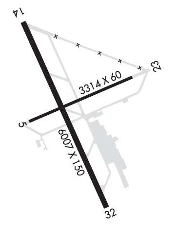
| Lat: N 3905.9 Long: W 12134.2 Elev: 64 Var: -16 Longest Runway: 6007 | ||
| AWOS: 118.47 CTAF: 123.05 | ||
| ||||||||||||||||||||||||||||||||||||||||||||
| ||||||||||||||||||||||||||||||||||||||||||||
| ||||||||||||||||||||||||||||||||||||||||||||
| Rwy | Rwy | |||||||
| 3314x60 | 3314' | 3314x60 | 3314' | |||||
| 6007x150 | 6007' | 110.50 - 140° | 6007x150 | 6007' | ||||
| Runway ID | Single Wheel | Double Wheel | Double Tandem Wheel | Dual Double Wheel |
| 05/23 | 42,000 | 60,000 | 95,000 | N/A |
| 14/32 | 75,000 | 100,000 | 150,000 | N/A |
| These numbers are Advisory and are not limits. The Airport Manager should have more accurate Weight Limits | ||||
 Airport Diagram might not be current. | |
| Facility Name: | YUBA COUNTY |
| City Name: | MARYSVILLE |
| County: | YUBA |
| State abbrev: | CA |
| State Name: | CALIFORNIA |
| Ownership: | PUBLICLY OWNED |
| Use: | OPEN TO THE PUBLIC |
| Owner's Name: | YUBA COUNTY |
| Address: | 915 8TH STREET |
| MARYSVILLE, CA 95901 | |
| Owner's Phone: | 530-741-7575 |
| Manager's Name: | JASON KOPPING |
| Address: | 1364 SKY HARBOR DRIVE |
| OLIVEHURST, CA 95961 | |
| Phone: | 530-741-6463 |
| FAA Region: | WESTERN-PACIFIC |
| FAA Field Office: | SFO |
| Date | Sunrise | Sunset |
|---|---|---|
| 09/24/21 Friday | 6:56 | 19:00 |
| 09/25/21 Saturday | 6:57 | 18:59 |
| 09/26/21 Sunday | 6:57 | 18:57 |
| 09/27/21 Monday | 6:58 | 18:55 |
| 09/28/21 Tuesday | 6:59 | 18:54 |
| 09/29/21 Wednesday | 7:00 | 18:52 |
| 09/30/21 Thursday | 7:01 | 18:51 |
| 10/01/21 Friday | 7:02 | 18:49 |
| 10/02/21 Saturday | 7:03 | 18:48 |
| 10/03/21 Sunday | 7:04 | 18:46 |
| 10/04/21 Monday | 7:05 | 18:44 |
| 10/05/21 Tuesday | 7:06 | 18:43 |
| 10/06/21 Wednesday | 7:07 | 18:41 |
| 10/07/21 Thursday | 7:08 | 18:40 |
| Airport Attendance Schedule | 7 Days A Week 0600-1800 |
| Airport Status | OPERATIONAL (This Status can change at any time - please check NOTAMS) |
| Airport Lighting Schedule | ACTVT MALSR RWY 14; VASI RWY 14 & 32, HIRL RWY 14/32 - CTAF |
| Airport Storage Available | Tie Downs, Hanger |
| Extra Services Available | Air Freight, Crop Dusting, Air Ambulance, Cargo Handling, Charter, Flight Instruction, Aircraft Rental, Aircraft Sales |
| Wind Indicator | YES - (unlit) |
| Control Tower | NO |
| CTAF Frequency | 123.050 |
| Unicom Frequency | 123.050 |
| Rotating Beacon Color | CLEAR-GREEN (Light Land Airport) |
| Segmented Circle | YES |
| Landing Fee | NO |
| Airport Inspected | STATE - performed by STATE AERONAUTICAL PERSONNEL |
| Inspection Date | 01/09/2020 |
| Type of Fuel Available | Grade 100LL, JET A (freeze point -40C) |
| Airframe Repair Service | MAJOR |
| Power Plant Repair Service | MINOR |
| Latitude | N3905.9 |
| Longitude | W12134.2 (ESTIMATED) |
| Arpt Elevation | 64ft (SURVEYED) |
| Magnetic Variation | 16E |
| 3 miles SE | of MARYSVILLE |
| Traffic Pattern Altitude | |
| Sectional Chart | SAN FRANCISCO |
| Operations (Reported) | Yearly | Avg. Daily |
|---|---|---|
| General Aviation Transient | 26000 | 71 |
| General Aviation Local | 9000 | 25 |
| Air Taxi | 300 | 1 |
| Commerical | 0 | 0 |
| Commuter | 0 | 0 |
| Military | 0 | 0 |
| Aircraft based on Field | |
|---|---|
| General Aviation Singles | 37 |
| General Aviation Multi | 3 |
| Jet Aircraft | 0 |
| General Aviation Helicopters | 2 |
| Military Aircraft | 0 |
| Gliders | 0 |
| Ultralights | 0 |
| FSS on field | NO |
| FSS tie-in | RANCHO MURIETA |
| FSS Phone | 1-800-WX-BRIEF |
| Who issues Notams | MYV |
| Notam D service at airport | YES |
| ARTCC Name | OAKLAND |
| Airport Certification | |
| Aircraft Rescue & Firefighting Index | None |
| Airport of Entry | No |
| Custom Landing Rights | No |
| Joint Civil/Military | No |
| Military Landing rights | YES |
| NATIONAL PLAN OF INTEGRATED AIRPORT SYSTEMS (NPIAS) |
| GRANT AGREEMENTS UNDER FAAP/ADAP/AIP |
| SURPLUS PROPERTY AGREEMENT UNDER PUBLIC LAW 289 |
| SURPLUS PROPERTY AGREEMENT UNDER REGULATION 16-WAA |
| ADVANCE PLANNING AGREEMENT UNDER FAAP |
| ASSURANCES PURSUANT TO TITLE VI, CIVIL RIGHTS ACT OF 1964 |
| RY 23 +35 FT PLINES 900-1050 FT FM RY END; RUNNING 145 FT LEFT TO 210 FT RIGHT. |
| MIGRATORY FLOCKS OF WATERFOWL IN VICINITY OF AIRPORT DURING THE SPRING AND FALL OF THE YEAR. |
| FOR CD CTC NORCAL APCH AT 916-361-6874. |
Airport Communications & Frequencies:
| ||||||||||||||
| Runway: 05 | Runway: 23 | ||
| Mag heading: | 51° | Mag heading: | 231° |
| Rwy Slope: | .07% Up | Rwy Slope: | -.07% Down |
| Approach: | Approach: | ||
| Pattern: | Left Traffic | Pattern: | Left Traffic |
| Markings: | BASIC | Markings: | BASIC |
| Marking Condition: | FAIR | Marking Condition: | FAIR |
| Arresting Dev: | Arresting Dev: | ||
| Lat & Long: | N3905.8 W12134.4 | Lat. & Long.: | N3906.0 W12133.8 |
| Elev: | 61.9 ft. MSL | Elev: | 64.3 ft. MSL |
| TCH: | TCH: | ||
| Visual Glide Path: | Visual Glide Path: | ||
| Displaced Threshold: | No | Displaced Threshold: | No |
| Touchdown Zone: | YES | Touchdown Zone: | YES |
| Touchdown Elev.: | 63.7 feet | Touchdown Elev.: | 64.3 feet |
| Visual Glide Slope: | Visual Glide Slope: | ||
| RVR Equipment: | RVR Equipment: | ||
| RVV Equipment: | NO | RVV Equipment: | NO |
| Approach Lights: | Approach Lights: | ||
| REIL: | NO | REIL: | NO |
| Centerline Lights: | NO | Centerline Lights: | NO |
| Touchdown lights: | NO | Touchdown lights: | NO |
| Runway Category: | Runway with a Visual Approach | Runway Category: | Runway with a Visual Approach |
| Declared Distances: | Declared Distances: | ||
| Obstructions: | RR | Obstructions: | TREE |
| Marked: | NOT Marked/Lighted | Marked: | NOT Marked/Lighted |
| Clearance slope: | 24:1 | Clearance slope: | 15:1 |
| Obstruction height: | 25 feet AGL | Obstruction height: | 45 feet AGL |
| Dist. from runway: | 800 feet | Dist. from runway: | 900 feet |
| Centerline offset: | 200 left of centerline | Centerline offset: | 50 feet right of centerline |
| Comments: | Comments: |
| Runway: 14 | Runway: 32 | ||
| Mag heading: | 141° | Mag heading: | 321° |
| Rwy Slope: | -.05% Down | Rwy Slope: | .05% Up |
| Approach: | ILS | Approach: | |
| Pattern: | Left Traffic | Pattern: | Left Traffic |
| Markings: | PRECISION INSTRUMENT | Markings: | PRECISION INSTRUMENT |
| Marking Condition: | GOOD | Marking Condition: | GOOD |
| Arresting Dev: | Arresting Dev: | ||
| Lat & Long: | N3906.3 W12134.5 | Lat. & Long.: | N3905.4 W12134.0 |
| Elev: | 63.2 ft. MSL | Elev: | 60.1 ft. MSL |
| TCH: | 50 ft. AGL | TCH: | 32 ft. AGL |
| Visual Glide Path: | 3.00 degrees | Visual Glide Path: | 3.00 degrees |
| Displaced Threshold: | No | Displaced Threshold: | No |
| Touchdown Zone: | YES | Touchdown Zone: | YES |
| Touchdown Elev.: | 63.9 feet | Touchdown Elev.: | 63.5 feet |
| Visual Glide Slope: | 4-BOX VASI ON LEFT SIDE OF RUNWAY | Visual Glide Slope: | 4-BOX VASI ON LEFT SIDE OF RUNWAY |
| RVR Equipment: | RVR Equipment: | ||
| RVV Equipment: | NO | RVV Equipment: | NO |
| Approach Lights: | MALSR - 1,400 foot medium intensity approach lighting system with runway alignment indicator lights | Approach Lights: | |
| REIL: | NO | REIL: | NO |
| Centerline Lights: | NO | Centerline Lights: | NO |
| Touchdown lights: | NO | Touchdown lights: | NO |
| Runway Category: | Precision Instrument Runway | Runway Category: | Runway with a Non-precision Approach having visibility minimums greater than 3/4 mile |
| Declared Distances: | Declared Distances: | ||
| Obstructions: | TREE | Obstructions: | POLE |
| Marked: | NOT Marked/Lighted | Marked: | NOT Marked/Lighted |
| Clearance slope: | 44:1 | Clearance slope: | 39:1 |
| Obstruction height: | 65 feet AGL | Obstruction height: | 39 feet AGL |
| Dist. from runway: | 3200 feet | Dist. from runway: | 1750 feet |
| Centerline offset: | 300 left of centerline | Centerline offset: | 175 feet right of centerline |
| Comments: | Comments: |
Thanks for using FltPlan.com
all rights reserved © 1999-2021 by Flight Plan LLC
