
| MYRTLE BEACH INTL MYRTLE BEACH SC |
| |
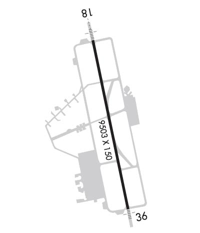
| Lat: N 3340.8 Long: W 07855.7 Elev: 25 Var: +09 Longest Runway: 9503 | ||
| Clr Del: 120.3 Dept. ATIS: 123.92 Arr. ATIS: 123.92 AWOS: 124.5 Ground: 120.3 Tower: 128.45 | ||
| ||||||||||||||||||||||||||||||||||||||||||||
| ||||||||||||||||||||||||||||||||||||||||||||
| ||||||||||||||||||||||||||||||||||||||||||||
| Rwy | Rwy | |||||||
| 9503x150 | 9503' | 109.50 - 177° | 9503x150 | 9503' | 111.90 - 357° | |||
| Runway ID | Single Wheel | Double Wheel | Double Tandem Wheel | Dual Double Wheel |
| 18/36 | 120,000 | 233,000 | 424,000 | 943,000 |
| These numbers are Advisory and are not limits. The Airport Manager should have more accurate Weight Limits | ||||
 Airport Diagram might not be current. | |
| Facility Name: | MYRTLE BEACH INTL |
| City Name: | MYRTLE BEACH |
| County: | HORRY |
| State abbrev: | SC |
| State Name: | SOUTH CAROLINA |
| Ownership: | PUBLICLY OWNED |
| Use: | OPEN TO THE PUBLIC |
| Owner's Name: | HORRY COUNTY |
| Address: | P O BOX 1236 |
| CONWAY, SC 29526 | |
| Owner's Phone: | 843-448-1580 |
| Manager's Name: | JUDI OLMSTEAD |
| Address: | 1100 JETPORT RD |
| MYRTLE BEACH, SC 29577 | |
| Phone: | 843-448-1580; ATCT MANAGER 843-238-3008, EXT 1. VANMOPPES@HORRYCOUNTY.ORG |
| FAA Region: | SOUTHERN |
| FAA Field Office: | ATL |
| Date | Sunrise | Sunset |
|---|---|---|
| 06/07/26 Sunday | 6:05 | 20:24 |
| 06/08/26 Monday | 6:05 | 20:25 |
| 06/09/26 Tuesday | 6:05 | 20:25 |
| 06/10/26 Wednesday | 6:05 | 20:26 |
| 06/11/26 Thursday | 6:05 | 20:26 |
| 06/12/26 Friday | 6:05 | 20:26 |
| 06/13/26 Saturday | 6:05 | 20:27 |
| 06/14/26 Sunday | 6:05 | 20:27 |
| 06/15/26 Monday | 6:05 | 20:28 |
| 06/16/26 Tuesday | 6:05 | 20:28 |
| 06/17/26 Wednesday | 6:05 | 20:28 |
| 06/18/26 Thursday | 6:05 | 20:29 |
| 06/19/26 Friday | 6:05 | 20:29 |
| 06/20/26 Saturday | 6:05 | 20:29 |
| Airport Attendance Schedule | 7 Days A Week 0600-2100 |
| Airport Status | OPERATIONAL (This Status can change at any time - please check NOTAMS) |
| Airport Lighting Schedule | WHEN ATCT CLSD ACTVT MALSR RWY 18, MALSF RWY 36; HIRL RWY 18/36 - CTAF. |
| Airport Storage Available | Tie Downs |
| Extra Services Available | Charter, Flight Instruction, Aircraft Rental |
| Wind Indicator | YES - (unlit) |
| Control Tower | YES |
| CTAF Frequency | 128.450 |
| Unicom Frequency | 122.950 |
| Rotating Beacon Color | WG |
| Segmented Circle | YES |
| Landing Fee |
| Airport Inspected | FEDERAL - performed by FAA AIRPORTS FIELD PERSONNEL |
| Inspection Date | 05/10/2024 |
| Type of Fuel Available | Grade 100LL, JET A (freeze point -40C) |
| Airframe Repair Service | MAJOR |
| Power Plant Repair Service | MAJOR |
| Latitude | N3340.8 |
| Longitude | W07855.7 (ESTIMATED) |
| Arpt Elevation | 25ft (SURVEYED) |
| Magnetic Variation | 09W |
| 3 miles SW | of MYRTLE BEACH |
| Traffic Pattern Altitude | |
| Sectional Chart | CHARLOTTE |
| Operations (Reported) | Yearly | Avg. Daily |
|---|---|---|
| General Aviation Transient | 0 | 0 |
| General Aviation Local | 0 | 0 |
| Air Taxi | 0 | 0 |
| Commerical | 0 | 0 |
| Commuter | 0 | 0 |
| Military | 0 | 0 |
| Aircraft based on Field | |
|---|---|
| General Aviation Singles | 0 |
| General Aviation Multi | 0 |
| Jet Aircraft | 0 |
| General Aviation Helicopters | 0 |
| Military Aircraft | 0 |
| Gliders | 0 |
| Ultralights | 0 |
| FSS on field | NO |
| FSS tie-in | ANDERSON |
| FSS Phone | 1-800-WX-BRIEF |
| Who issues Notams | MYR |
| Notam D service at airport | YES |
| ARTCC Name | JACKSONVILLE |
| Airport Certification | AIRPORT RECEIVING SCHEDULED AIR CARRIER SERVICE FROM CARRIERS CERTIFICATED BY THE CIVIL AERONAUTICS BOARD |
| Aircraft Rescue & Firefighting Index | AIRPORT HAS A CERTIFICATE UNDER CFR PART 139 |
| Airport of Entry | No |
| Custom Landing Rights | No; US CUSTOMS USER FEE ARPT. |
| Joint Civil/Military | No |
| Military Landing rights | YES |
| NATIONAL PLAN OF INTEGRATED AIRPORT SYSTEMS (NPIAS) |
| GRANT AGREEMENTS UNDER FAAP/ADAP/AIP |
| ASSURANCES PURSUANT TO TITLE VI, CIVIL RIGHTS ACT OF 1964 |
| GULLS ON & INVOF ARPT. |
| APVL RQRD FOR PUSHBACK AT TRML GATES A9, A10, A11, A12, A14. CTC MYR GC 120.3; PUSH IS AT PILOT DISCRETION ALL OTR GATES; RMN CLR OF TWYS. |
| CTC MYR OPS ON CTAF 128.45 PRIOR TO LNDG 2300-0600. |
| SIGHTSEEING HELS OPRG IN CLOSE PROXIMITY OF ARPT AND RWY AT OR BLW 1200 FT. HEL RTES AND HLDG POINTS RMN CLR OF RWY CNTRLNS. HELS DEPG/ARRG PAD LCTD 700 FT SSE APCH END RWY 36. |
| MEDEVAC HEL DEPG GRAND STRAND MED CTR, SW BOUND, CTC MYR TWR ON 134.05 PRIOR TO DEP OR AS SOON AS AB. |
| PILOTS CONDUCTING EFVS OPS; BE AWARE LED ALS IN USE RWY 18 & RWY 36. |
| RWY 18/3 6 PCR VALUE: 302/F/A/X/T |
Airport Communications & Frequencies:
| |||||||||||||||||||||||||||||||||||||||||||||||||
| Runway: 18 | Runway: 36 | ||
| Mag heading: | 177° | Mag heading: | 357° |
| Rwy Slope: | -.01% Down | Rwy Slope: | .01% Up |
| Approach: | ILS/DME | Approach: | ILS |
| Pattern: | Right Traffic | Pattern: | Left Traffic |
| Markings: | PRECISION INSTRUMENT | Markings: | PRECISION INSTRUMENT |
| Marking Condition: | GOOD | Marking Condition: | GOOD |
| Arresting Dev: | MA-1A | Arresting Dev: | MA-1A |
| Lat & Long: | N3341.6 W07855.9 | Lat. & Long.: | N3340.0 W07855.5 |
| Elev: | 22.5 ft. MSL | Elev: | 21.8 ft. MSL |
| TCH: | 64 ft. AGL | TCH: | 71 ft. AGL |
| Visual Glide Path: | 3.00 degrees | Visual Glide Path: | 3.00 degrees |
| Displaced Threshold: | No | Displaced Threshold: | No |
| Touchdown Zone: | YES | Touchdown Zone: | YES |
| Touchdown Elev.: | 23.4 feet | Touchdown Elev.: | 25.0 feet |
| Visual Glide Slope: | 4-Light PAPI on LEFT side of Runway | Visual Glide Slope: | 4-Light PAPI on LEFT side of Runway |
| RVR Equipment: | TOUCHDOWN-ROLLOUT | RVR Equipment: | TOUCHDOWN-ROLLOUT |
| RVV Equipment: | NO | RVV Equipment: | NO |
| Approach Lights: | MALSR - 1,400 foot medium intensity approach lighting system with runway alignment indicator lights | Approach Lights: | MALSF - 1,400 foot medium intensity approach lighting system with sequenced flashers |
| REIL: | NO | REIL: | NO |
| Centerline Lights: | NO | Centerline Lights: | NO |
| Touchdown lights: | NO | Touchdown lights: | NO |
| Runway Category: | Precision Instrument Runway | Runway Category: | Precision Instrument Runway |
| Declared Distances: | Declared Distances: | ||
| Obstructions: | PLINE | Obstructions: | TREES |
| Marked: | NOT Marked/Lighted | Marked: | NOT Marked/Lighted |
| Clearance slope: | 50:1 | Clearance slope: | 50:1 |
| Obstruction height: | Obstruction height: | ||
| Dist. from runway: | 3000 feet | Dist. from runway: | 2100 feet |
| Centerline offset: | Centerline offset: | ||
| Comments: | Comments: |
Thanks for using FltPlan.com
all rights reserved © 1999-2026 by Flight Plan LLC
