| LYNDEN PINDLING INTL NASSAU |
| |
| Lat: N 2502.3 Long: W 07728.0 Elev: 16 Var: +08 Longest Runway: 11107 | ||
| Clr Del: 118.3 Dept. ATIS: 118.7 Arr. ATIS: 118.7 Ground: 121.7 Tower: 119.5 | ||
| |||||||||||||||||||||||||||||||||||||||||||||||||||||||||||||||||||||
| |||||||||||||||||||||||||||||||||||||||||||||||||||||||||||||||||||||
| |||||||||||||||||||||||||||||||||||||||||||||||||||||||||||||||||||||
| |||||||||||||||||||||||||||||||||||||||||||||||||||||||||||||||||||||
| |||||||||||||||||||||||||||||||||||||||||||||||||||||||||||||||||||||
| Rwy | Rwy | |||||||
| 8273x150 | 8273' | 8273x150 | 8273' | |||||
| 11107x150 | 10921' | 11107x150 | 11107' | |||||
| Runway ID | Single Wheel | Double Wheel | Double Tandem Wheel | Dual Double Wheel |
| 09/27 | N/A | N/A | N/A | N/A |
| 14/32 | N/A | N/A | N/A | N/A |
| These numbers are Advisory and are not limits. The Airport Manager should have more accurate Weight Limits | ||||
| FltPlan does not have IFR approach charts available for MYNN. |
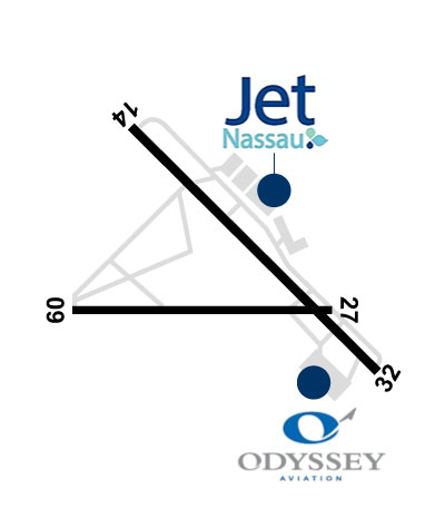 Airport Diagram might not be current. | |
| Facility Name: | LYNDEN PINDLING INTL |
| City Name: | NASSAU |
| County: | BAHAMAS |
| State abbrev: | |
| State Name: | |
| Ownership: | PUBLICLY OWNED |
| Use: | OPEN TO THE PUBLIC; FOREIGN CIV GOVT. LNDG FEES AND DIPLOMATIC CLNC MAY BE RQR. |
| Owner's Name: | |
| Address: | |
| Owner's Phone: | |
| Manager's Name: | NASSAU AIRPORT DEVELOPMENT COMPANY |
| Address: | |
| Phone: | 1-800-242-702-1000 |
| FAA Region: | |
| FAA Field Office: | NONE |
| Date | Sunrise | Sunset |
|---|---|---|
| 09/24/21 Friday | 6:59 | 19:04 |
| 09/25/21 Saturday | 6:59 | 19:03 |
| 09/26/21 Sunday | 7:00 | 19:02 |
| 09/27/21 Monday | 7:00 | 19:01 |
| 09/28/21 Tuesday | 7:01 | 19:00 |
| 09/29/21 Wednesday | 7:01 | 18:59 |
| 09/30/21 Thursday | 7:01 | 18:58 |
| 10/01/21 Friday | 7:02 | 18:57 |
| 10/02/21 Saturday | 7:02 | 18:56 |
| 10/03/21 Sunday | 7:03 | 18:55 |
| 10/04/21 Monday | 7:03 | 18:54 |
| 10/05/21 Tuesday | 7:03 | 18:53 |
| 10/06/21 Wednesday | 7:04 | 18:52 |
| 10/07/21 Thursday | 7:04 | 18:51 |
| Airport Attendance Schedule | CONTINUOUS |
| Airport Status | OPERATIONAL (This Status can change at any time - please check NOTAMS) |
| Airport Lighting Schedule | |
| Airport Storage Available | NONE |
| Extra Services Available | Cargo Handling |
| Wind Indicator | NONE |
| Control Tower | YES |
| CTAF Frequency | |
| Unicom Frequency | 122.800 |
| Rotating Beacon Color | CLEAR-GREEN (Light Land Airport) |
| Segmented Circle | NO |
| Landing Fee |
| Airport Inspected | No Inspection Data Available performed by the OWNER |
| Inspection Date | Unknown |
| Type of Fuel Available | Grade 100LL, JET A-1 (freeze point -50C) |
| Airframe Repair Service | None |
| Power Plant Repair Service | None |
| Latitude | N2502.3 |
| Longitude | W07728.0 (ESTIMATED) |
| Arpt Elevation | 16ft (ESTIMATED) |
| Magnetic Variation | 08W |
| 7 miles W | of NASSAU |
| Traffic Pattern Altitude | |
| Sectional Chart | MIAMI |
| Operations (Reported) | Yearly | Avg. Daily |
|---|---|---|
| General Aviation Transient | 0 | 0 |
| General Aviation Local | 0 | 0 |
| Air Taxi | 0 | 0 |
| Commerical | 0 | 0 |
| Commuter | 0 | 0 |
| Military | 0 | 0 |
| Aircraft based on Field | |
|---|---|
| General Aviation Singles | 0 |
| General Aviation Multi | 0 |
| Jet Aircraft | 0 |
| General Aviation Helicopters | 0 |
| Military Aircraft | 0 |
| Gliders | 0 |
| Ultralights | 0 |
| FSS on field | NO |
| FSS tie-in | MIAMI; NASSAU FLT SVC FOR LCL INFO 1-242-377-7116/2006; EMERG 1-242-377-2040. |
| FSS Phone | 1-800-WX-BRIEF |
| Who issues Notams | |
| Notam D service at airport | No |
| ARTCC Name | MIAMI |
| Airport Certification | |
| Aircraft Rescue & Firefighting Index | None |
| Airport of Entry | YES |
| Custom Landing Rights | No |
| Joint Civil/Military | No |
| Military Landing rights | No |
| FIREFIGHT EQUIP: OSHKOSH, 3,000 GALS WATER, 420 GALS FOAM, 500 LBS DRY CHM; OSHKOSH, 1,500 GALS WATER, 210 GALS FOAM, 500 LBS DRY CHM; OSHKOSH, 1,500 GALS WATER, 210 GALS FOAM, 500 LBS DRY CHM; OSHKOSH, 1,500 GALS WATER, 210 GALS FOAM; FORD, 300 GALS WATER, 20 GALS FOAM, 500 LBS DRY CHM AVBL. |
| TWR HAS LTD VIS OF ACFT ON APRON 1 & STANDS 56-59. |
Airport Communications & Frequencies:
| |||||||||||||||||||||
| Runway: 09 | Runway: 27 | ||
| Mag heading: | 98° | Mag heading: | 278° |
| Rwy Slope: | -.01% Down | Rwy Slope: | .01% Up |
| Approach: | Approach: | ||
| Pattern: | Left Traffic | Pattern: | Left Traffic |
| Markings: | Markings: | ||
| Marking Condition: | Marking Condition: | ||
| Arresting Dev: | Arresting Dev: | ||
| Lat & Long: | N2502.2 W07728.9 | Lat. & Long.: | N2502.2 W07727.4 |
| Elev: | 14.0 ft. MSL | Elev: | 13.0 ft. MSL |
| TCH: | 69 ft. AGL | TCH: | 70 ft. AGL |
| Visual Glide Path: | 3.00 degrees | Visual Glide Path: | 3.00 degrees |
| Displaced Threshold: | No | Displaced Threshold: | No |
| Touchdown Zone: | YES | Touchdown Zone: | YES |
| Touchdown Elev.: | 15.0 feet | Touchdown Elev.: | 16.0 feet |
| Visual Glide Slope: | 4-Light PAPI on LEFT side of Runway | Visual Glide Slope: | 4-Light PAPI on LEFT side of Runway |
| RVR Equipment: | RVR Equipment: | ||
| RVV Equipment: | NO | RVV Equipment: | NO |
| Approach Lights: | SSALS - simplified short approach lighting system; NSTD. | Approach Lights: | |
| REIL: | NO | REIL: | NO |
| Centerline Lights: | NO | Centerline Lights: | NO |
| Touchdown lights: | NO | Touchdown lights: | NO |
| Runway Category: | Runway Category: | ||
| Declared Distances: | TORA:8273' TODA:8273' ASDA:8273' LDA:8273' | Declared Distances: | TORA:8273' TODA:8273' ASDA:8273' LDA:8273' |
| Runway: 14 | Runway: 32 | ||
| Mag heading: | 143° | Mag heading: | 323° |
| Rwy Slope: | .02% Up | Rwy Slope: | -.02% Down |
| Approach: | Approach: | ||
| Pattern: | Left Traffic | Pattern: | Left Traffic |
| Markings: | Markings: | ||
| Marking Condition: | Marking Condition: | ||
| Arresting Dev: | Arresting Dev: | ||
| Lat & Long: | N2503.1 W07728.6 | Lat. & Long.: | N2501.8 W07727.1 |
| Elev: | 12.0 ft. MSL | Elev: | 14.0 ft. MSL |
| TCH: | 75 ft. AGL | TCH: | 78 ft. AGL |
| Visual Glide Path: | 3.00 degrees | Visual Glide Path: | 3.00 degrees |
| Displaced Threshold: | 186 feet | Displaced Threshold: | No |
| Touchdown Zone: | YES | Touchdown Zone: | YES |
| Touchdown Elev.: | 16.0 feet | Touchdown Elev.: | 14.0 feet |
| Visual Glide Slope: | 4-Light PAPI on LEFT side of Runway | Visual Glide Slope: | 4-Light PAPI on LEFT side of Runway |
| RVR Equipment: | RVR Equipment: | ||
| RVV Equipment: | NO | RVV Equipment: | NO |
| Approach Lights: | SSALS - simplified short approach lighting system | Approach Lights: | |
| REIL: | NO | REIL: | NO |
| Centerline Lights: | NO | Centerline Lights: | NO |
| Touchdown lights: | NO | Touchdown lights: | NO |
| Runway Category: | Runway Category: | ||
| Declared Distances: | TORA:11353' TODA:11353' ASDA:11353' LDA:11143' | Declared Distances: | TORA:11353' TODA:11353' ASDA:11353' LDA:11353' |
Thanks for using FltPlan.com
all rights reserved © 1999-2021 by Flight Plan LLC