
| MC CALL MUNI MC CALL ID |
| |
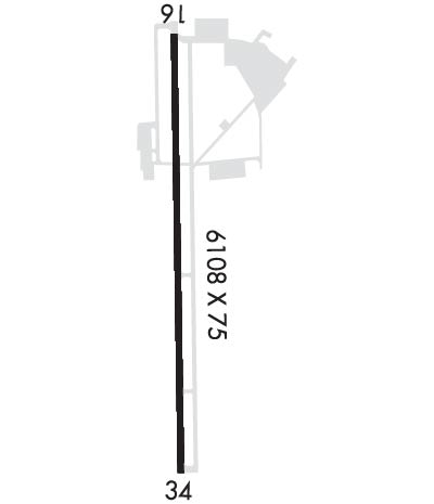
| Lat: N 4453.3 Long: W 11606.1 Elev: 5024 Var: -13 Longest Runway: 6101 | ||
| AWOS: 119.92 CTAF: 122.8 | ||
| ||||||||||||||||||||||||||||||||||||||||||||
| ||||||||||||||||||||||||||||||||||||||||||||
| ||||||||||||||||||||||||||||||||||||||||||||
| Rwy | Rwy | |||||||
| 6101x75 | 6101' | 6101x75 | 6101' | |||||
| Runway ID | Single Wheel | Double Wheel | Double Tandem Wheel | Dual Double Wheel |
| 16/34 | 86,500 | 141,000 | 261,500 | N/A |
| These numbers are Advisory and are not limits. The Airport Manager should have more accurate Weight Limits | ||||
 Airport Diagram might not be current. | |
| Facility Name: | MC CALL MUNI |
| City Name: | MC CALL |
| County: | VALLEY |
| State abbrev: | ID |
| State Name: | IDAHO |
| Ownership: | PUBLICLY OWNED |
| Use: | OPEN TO THE PUBLIC |
| Owner's Name: | CITY OF MCCALL |
| Address: | 216 E PARK |
| MC CALL, ID 83638 | |
| Owner's Phone: | 208-634-7142 |
| Manager's Name: | EMILY HART |
| Address: | 216 E PARK |
| MC CALL, ID 83638 | |
| Phone: | 208-634-1488 |
| FAA Region: | NORTHWEST MOUNTAIN |
| FAA Field Office: | HLN |
| Date | Sunrise | Sunset |
|---|---|---|
| 06/12/26 Friday | 5:58 | 21:31 |
| 06/13/26 Saturday | 5:58 | 21:31 |
| 06/14/26 Sunday | 5:57 | 21:32 |
| 06/15/26 Monday | 5:57 | 21:32 |
| 06/16/26 Tuesday | 5:57 | 21:33 |
| 06/17/26 Wednesday | 5:57 | 21:33 |
| 06/18/26 Thursday | 5:58 | 21:34 |
| 06/19/26 Friday | 5:58 | 21:34 |
| 06/20/26 Saturday | 5:58 | 21:34 |
| 06/21/26 Sunday | 5:58 | 21:34 |
| 06/22/26 Monday | 5:58 | 21:34 |
| 06/23/26 Tuesday | 5:59 | 21:35 |
| 06/24/26 Wednesday | 5:59 | 21:35 |
| 06/25/26 Thursday | 5:59 | 21:35 |
| Airport Attendance Schedule | MAY-SEP 7 Days A Week 0800L-1800L, OCT-APR 7 Days A Week 0900L-1600L |
| Airport Status | OPERATIONAL (This Status can change at any time - please check NOTAMS) |
| Airport Lighting Schedule | ACTIVATE REIL RWY 16 & 34; MIRL RWY 16/34 - CTAF. |
| Airport Storage Available | Tie Downs, Hanger |
| Extra Services Available | Air Ambulance, Charter, Flight Instruction, Aircraft Rental, Aircraft Sales |
| Wind Indicator | YES - (lighted) |
| Control Tower | NO |
| CTAF Frequency | 122.800 |
| Unicom Frequency | 122.800 |
| Rotating Beacon Color | WG |
| Segmented Circle | YES |
| Landing Fee | NO |
| Airport Inspected | STATE - performed by STATE AERONAUTICAL PERSONNEL |
| Inspection Date | 05/29/2025 |
| Type of Fuel Available | Grade 100LL, JET A (freeze point -40C), JET A-1 (icing inhibitor, freeze point -50C) |
| Airframe Repair Service | MAJOR |
| Power Plant Repair Service | MAJOR |
| Latitude | N4453.3 |
| Longitude | W11606.1 (ESTIMATED) |
| Arpt Elevation | 5024ft (SURVEYED) |
| Magnetic Variation | 13E |
| 0 miles S | of MC CALL |
| Traffic Pattern Altitude | |
| Sectional Chart | GREAT FALLS |
| Operations (Reported) | Yearly | Avg. Daily |
|---|---|---|
| General Aviation Transient | 0 | 0 |
| General Aviation Local | 0 | 0 |
| Air Taxi | 0 | 0 |
| Commerical | 0 | 0 |
| Commuter | 0 | 0 |
| Military | 0 | 0 |
| Aircraft based on Field | |
|---|---|
| General Aviation Singles | 0 |
| General Aviation Multi | 0 |
| Jet Aircraft | 0 |
| General Aviation Helicopters | 0 |
| Military Aircraft | 0 |
| Gliders | 0 |
| Ultralights | 0 |
| FSS on field | NO |
| FSS tie-in | BOISE |
| FSS Phone | 1-800-WX-BRIEF |
| Who issues Notams | MYL |
| Notam D service at airport | YES |
| ARTCC Name | SALT LAKE CITY |
| Airport Certification | |
| Aircraft Rescue & Firefighting Index | None |
| Airport of Entry | No |
| Custom Landing Rights | No |
| Joint Civil/Military | No |
| Military Landing rights | YES |
| NATIONAL PLAN OF INTEGRATED AIRPORT SYSTEMS (NPIAS) |
| GRANT AGREEMENTS UNDER FAAP/ADAP/AIP |
| ASSURANCES PURSUANT TO TITLE VI, CIVIL RIGHTS ACT OF 1964 |
| AUX PWR UNITS MAY NOT BE STARTED UNTIL 30 MINS PRIOR TO ENGINE START. FEES WILL BE CHRGD FOR APU USAGE OVER 30 MIN. |
| COLD TEMPERATURE AIRPORT. ALTITUDE CORRECTION REQUIRED AT OR BELOW -19C. |
| AIRPORT SURFACE CONDITIONS REPORTED M-F 0800-1700 LCL |
| 2 HR PRIOR NOTICE REQUIRED FOR SNOW REMOVAL AT NIGHT CALL 208-634-1488/630-3441 |
| FOR CD CTC SALT LAKE ARTCC AT 801-320-2568. |
| LNDG AND PRKG FEES COLLD BY THIRD PARTY PROVIDER. SEE MCCALLAIRPORT.COM FOR ADNL DTLS. |
| SELF-SERVE 100LL ONLY. |
| USFS PRACTICES PARACHUTE JUMPS INVOF ARPT. |
| BIG GAME ANIMALS MAY BE ON OR IN VICINITY OF RY. |
| NO HELICOPTER PARKING IN FIXED WING TIE-DOWN AREAS. |
| RY 16 HAS A MARKED 50 FT BLAST PAD. |
| INCREASED FOREST SERVICE FLIGHT OPNS DURG SUMMER MONTHS. |
| PARALLEL TWY CLSD DEC 1-APR 30. |
| RWY 16/3 4 RECOMMEND LNDG RWY 34 AND TKOF RWY 16 WHEN WIND CONDS PERMIT. |
Airport Communications & Frequencies:
| |||||||||
| Runway: 16 | Runway: 34 | ||
| Mag heading: | 166° | Mag heading: | 346° |
| Rwy Slope: | -.29% Down | Rwy Slope: | .29% Up |
| Approach: | Approach: | ||
| Pattern: | Left Traffic | Pattern: | Left Traffic |
| Markings: | NONPRECISION INSTRUMENT | Markings: | NONPRECISION INSTRUMENT |
| Marking Condition: | FAIR | Marking Condition: | FAIR |
| Arresting Dev: | Arresting Dev: | ||
| Lat & Long: | N4453.8 W11606.1 | Lat. & Long.: | N4452.8 W11606.1 |
| Elev: | 5024.1 ft. MSL | Elev: | 5006.6 ft. MSL |
| TCH: | TCH: | 58 ft. AGL | |
| Visual Glide Path: | Visual Glide Path: | 3.50 degrees | |
| Displaced Threshold: | No | Displaced Threshold: | No |
| Touchdown Zone: | YES | Touchdown Zone: | YES |
| Touchdown Elev.: | 5024.1 feet | Touchdown Elev.: | 5012.4 feet |
| Visual Glide Slope: | Visual Glide Slope: | 2-Box VASI on LEFT side of Runway | |
| RVR Equipment: | RVR Equipment: | ||
| RVV Equipment: | NO | RVV Equipment: | NO |
| Approach Lights: | Approach Lights: | ||
| REIL: | YES | REIL: | YES |
| Centerline Lights: | NO | Centerline Lights: | NO |
| Touchdown lights: | NO | Touchdown lights: | NO |
| Runway Category: | Runway with a Non-precision Approach having visibility minimums greater than 3/4 mile | Runway Category: | Runway with a Non-precision Approach having visibility minimums greater than 3/4 mile |
| Declared Distances: | Declared Distances: | ||
| Obstructions: | ROAD | Obstructions: | GND |
| Marked: | NOT Marked/Lighted | Marked: | NOT Marked/Lighted |
| Clearance slope: | 28:1 | Clearance slope: | 16:1 |
| Obstruction height: | 16 feet AGL | Obstruction height: | 80 feet AGL |
| Dist. from runway: | 650 feet | Dist. from runway: | 1500 feet |
| Centerline offset: | Centerline offset: | ||
| Comments: | Comments: |
Thanks for using FltPlan.com
all rights reserved © 1999-2026 by Flight Plan LLC