
| MIDDLETOWN REGIONAL/HOOK FIELD MIDDLETOWN OH |
| |
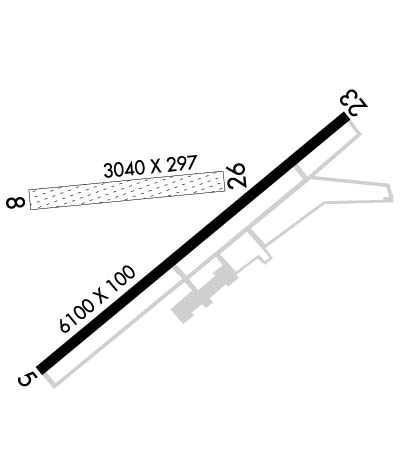
| Lat: N 3931.9 Long: W 08423.8 Elev: 651 Var: +04 Longest Runway: 6100 | ||
| AWOS: 120.02 CTAF: 123.0 | ||
| ||||||
| ||||||
|
| Rwy | Rwy | |||||||
| 6100x100 | 6100' | 6100x100 | 5801' | 111.10 - 233° | ||||
| 3026x160 | 2075' | 3026x160 | 3026' | |||||
| Runway ID | Single Wheel | Double Wheel | Double Tandem Wheel | Dual Double Wheel |
| 05/23 | 66,000 | 78,000 | 140,000 | N/A |
| 08/26 | N/A | N/A | N/A | N/A |
| These numbers are Advisory and are not limits. The Airport Manager should have more accurate Weight Limits | ||||
 Airport Diagram might not be current. | |
| Facility Name: | MIDDLETOWN RGNL/HOOK FLD |
| City Name: | MIDDLETOWN |
| County: | BUTLER |
| State abbrev: | OH |
| State Name: | OHIO |
| Ownership: | PUBLICLY OWNED |
| Use: | OPEN TO THE PUBLIC |
| Owner's Name: | CITY OF MIDDLETOWN |
| Address: | 1 DONHAM PLZ |
| MIDDLETOWN, OH 45042-1932 | |
| Owner's Phone: | 513-425-7845 |
| Manager's Name: | DAN DICKTEN, AAE |
| Address: | 1707 RUN WAY |
| MIDDLETOWN, OH 45042-2300 | |
| Phone: | 513-422-9750; CELL 513-267-0646. |
| FAA Region: | GREAT LAKES |
| FAA Field Office: | DET |

| Date | Sunrise | Sunset |
|---|---|---|
| 09/24/21 Friday | 7:27 | 19:32 |
| 09/25/21 Saturday | 7:28 | 19:30 |
| 09/26/21 Sunday | 7:29 | 19:29 |
| 09/27/21 Monday | 7:30 | 19:27 |
| 09/28/21 Tuesday | 7:31 | 19:25 |
| 09/29/21 Wednesday | 7:32 | 19:24 |
| 09/30/21 Thursday | 7:33 | 19:22 |
| 10/01/21 Friday | 7:33 | 19:20 |
| 10/02/21 Saturday | 7:34 | 19:19 |
| 10/03/21 Sunday | 7:35 | 19:17 |
| 10/04/21 Monday | 7:36 | 19:16 |
| 10/05/21 Tuesday | 7:37 | 19:14 |
| 10/06/21 Wednesday | 7:38 | 19:13 |
| 10/07/21 Thursday | 7:39 | 19:11 |
| Airport Attendance Schedule | 7 Days A Week 0800-1700 |
| Airport Status | OPERATIONAL (This Status can change at any time - please check NOTAMS) |
| Airport Lighting Schedule | ACTVT REIL RWY 05 & 23; MIRL RWY 05/23 - CTAF. |
| Airport Storage Available | Tie Downs, Hanger |
| Extra Services Available | Cargo Handling, Flight Instruction, Parachute Jumping, Aircraft Rental |
| Wind Indicator | YES - (lighted) |
| Control Tower | NO |
| CTAF Frequency | 123.000 |
| Unicom Frequency | 123.000 |
| Rotating Beacon Color | CLEAR-GREEN (Light Land Airport) |
| Segmented Circle | NO |
| Landing Fee | NO |
| Airport Inspected | STATE - performed by PRIVATE CONTRACT PERSONNEL |
| Inspection Date | 09/02/2016 |
| Type of Fuel Available | Grade 100LL, JET A (freeze point -40C), JET A |
| Airframe Repair Service | MAJOR |
| Power Plant Repair Service | MAJOR |
| Latitude | N3931.9 |
| Longitude | W08423.8 (ESTIMATED) |
| Arpt Elevation | 650ft (SURVEYED) |
| Magnetic Variation | 04W |
| 2 miles N | of MIDDLETOWN |
| Traffic Pattern Altitude | |
| Sectional Chart | CINCINNATI |
| Operations (Reported) | Yearly | Avg. Daily |
|---|---|---|
| General Aviation Transient | 18600 | 51 |
| General Aviation Local | 17800 | 49 |
| Air Taxi | 3600 | 10 |
| Commerical | 0 | 0 |
| Commuter | 0 | 0 |
| Military | 50 | 0 |
| Aircraft based on Field | |
|---|---|
| General Aviation Singles | 59 |
| General Aviation Multi | 5 |
| Jet Aircraft | 0 |
| General Aviation Helicopters | 2 |
| Military Aircraft | 0 |
| Gliders | 0 |
| Ultralights | 0; ULTRALIGHTS ENTER/EXIT PAT AT RY 08 TO NORTH - LOWER THAN REGULAR TFC PAT. ULTRALIGHTS DO NOT FLY SOUTH OF RY 26. |
| FSS on field | NO |
| FSS tie-in | DAYTON |
| FSS Phone | 1-800-WX-BRIEF |
| Who issues Notams | DAY |
| Notam D service at airport | YES |
| ARTCC Name | INDIANAPOLIS |
| Airport Certification | |
| Aircraft Rescue & Firefighting Index | None |
| Airport of Entry | No |
| Custom Landing Rights | No |
| Joint Civil/Military | No |
| Military Landing rights | YES |
| NATIONAL PLAN OF INTEGRATED AIRPORT SYSTEMS (NPIAS) |
| GRANT AGREEMENTS UNDER FAAP/ADAP/AIP |
| ASSURANCES PURSUANT TO TITLE VI, CIVIL RIGHTS ACT OF 1964 |
| FOR CD CTC COLUMBUS APCH AT 614-338-8537. |
| EXTENSIVE SKYDIVING ACTVTY. |
Airport Communications & Frequencies:
| ||||||||||||||||||
| Runway: 05 | Runway: 23 | ||
| Mag heading: | 53° | Mag heading: | 233° |
| Rwy Slope: | .14% Up | Rwy Slope: | -.14% Down |
| Approach: | Approach: | LOCALIZER | |
| Pattern: | Left Traffic | Pattern: | Right Traffic |
| Markings: | NONPRECISION INSTRUMENT | Markings: | NONPRECISION INSTRUMENT |
| Marking Condition: | FAIR | Marking Condition: | FAIR |
| Arresting Dev: | Arresting Dev: | ||
| Lat & Long: | N3931.5 W08424.2 | Lat. & Long.: | N3932.2 W08423.2 |
| Elev: | 641.8 ft. MSL | Elev: | 650.3 ft. MSL |
| TCH: | 20 ft. AGL | TCH: | 20 ft. AGL |
| Visual Glide Path: | 2.50 degrees | Visual Glide Path: | 2.50 degrees |
| Displaced Threshold: | No | Displaced Threshold: | 299 feet |
| Touchdown Zone: | YES | Touchdown Zone: | YES |
| Touchdown Elev.: | 645.4 feet | Touchdown Elev.: | 650.4 feet |
| Visual Glide Slope: | 4-Light PAPI on RIGHT side of Runway; PAPI UNUSBL. | Visual Glide Slope: | 4-Light PAPI on RIGHT side of Runway; PAPI UNUSBL. |
| RVR Equipment: | RVR Equipment: | ||
| RVV Equipment: | NO | RVV Equipment: | NO |
| Approach Lights: | Approach Lights: | ||
| REIL: | YES | REIL: | YES |
| Centerline Lights: | NO | Centerline Lights: | NO |
| Touchdown lights: | NO | Touchdown lights: | NO |
| Runway Category: | Runway with a Non-precision Approach having visibility minimums greater than 3/4 mile | Runway Category: | Runway with a Non-precision Approach having visibility minimums greater than 3/4 mile |
| Declared Distances: | Declared Distances: | ||
| Obstructions: | TREES | Obstructions: | TREE |
| Marked: | NOT Marked/Lighted | Marked: | NOT Marked/Lighted |
| Clearance slope: | 5:1; APCH RATIO 24:1 AT DSPLCD THLD. | Clearance slope: | 16:1; APCH RATIO 24:1 OVR 84 FT TREES; 2040 FT FM THLD 512 FT R. |
| Obstruction height: | 21 feet AGL | Obstruction height: | 41 feet AGL |
| Dist. from runway: | 320 feet | Dist. from runway: | 864 feet |
| Centerline offset: | 250 right of centerline | Centerline offset: | 260 feet right of centerline |
| Comments: | Comments: |
| Runway: 08 | Runway: 26 | ||
| Mag heading: | 89° | Mag heading: | 269° |
| Rwy Slope: | .05% Up | Rwy Slope: | -.05% Down |
| Approach: | Approach: | ||
| Pattern: | Left Traffic | Pattern: | Right Traffic |
| Markings: | Markings: | ||
| Marking Condition: | FAIR; 08/26 MKD WITH WHITE CONES. | Marking Condition: | FAIR |
| Arresting Dev: | Arresting Dev: | ||
| Lat & Long: | N3932.0 W08424.2 | Lat. & Long.: | N3932.0 W08423.6 |
| Elev: | 643.0 ft. MSL | Elev: | 644.4 ft. MSL |
| TCH: | TCH: | ||
| Visual Glide Path: | Visual Glide Path: | ||
| Displaced Threshold: | 951 feet | Displaced Threshold: | No |
| Touchdown Zone: | YES | Touchdown Zone: | YES |
| Touchdown Elev.: | 644.8 feet | Touchdown Elev.: | 644.8 feet |
| Visual Glide Slope: | Visual Glide Slope: | ||
| RVR Equipment: | RVR Equipment: | ||
| RVV Equipment: | NO | RVV Equipment: | NO |
| Approach Lights: | Approach Lights: | ||
| REIL: | NO | REIL: | NO |
| Centerline Lights: | NO | Centerline Lights: | NO |
| Touchdown lights: | NO | Touchdown lights: | NO |
| Runway Category: | Runway with a Visual Approach | Runway Category: | Runway with a Visual Approach |
| Declared Distances: | Declared Distances: | ||
| Obstructions: | TREES | Obstructions: | |
| Marked: | NOT Marked/Lighted | Marked: | |
| Clearance slope: | 16:1; APCH RATIO 20:1 AT DSPLCD THR. | Clearance slope: | 20:1 |
| Obstruction height: | 175 feet AGL | Obstruction height: | |
| Dist. from runway: | 2865 feet | Dist. from runway: | |
| Centerline offset: | Centerline offset: | ||
| Comments: | Comments: |
Thanks for using FltPlan.com
all rights reserved © 1999-2021 by Flight Plan LLC