
| MINERAL WELLS MINERAL WELLS TX |
| |
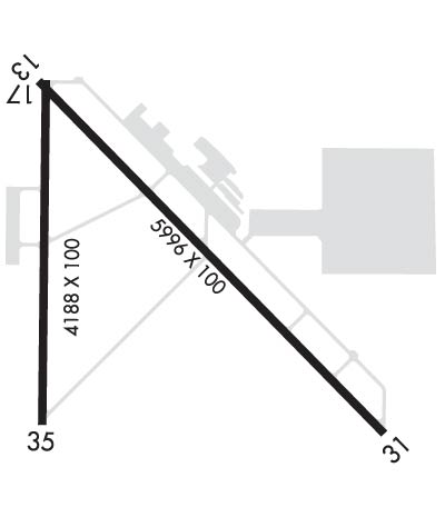
| Lat: N 3246.9 Long: W 09803.6 Elev: 974 Var: -06 Longest Runway: 5996 | ||
| Clr Del: 817-858-7584 AWOS: 135.07 CTAF: 122.72 | ||
| ||||||||||||||||||||||||||||||||||||||||||||
| ||||||||||||||||||||||||||||||||||||||||||||
| ||||||||||||||||||||||||||||||||||||||||||||
| Rwy | Rwy | |||||||
| 5996x100 | 5696' | 5996x100 | 5596' | 109.55 - 310° | ||||
| 4188x100 | 4188' | 4188x100 | 3902' | |||||
| Runway ID | Single Wheel | Double Wheel | Double Tandem Wheel | Dual Double Wheel |
| 13/31 | 50,000 | 145,000 | N/A | N/A |
| 17/35 | 50,000 | 145,000 | N/A | N/A |
| These numbers are Advisory and are not limits. The Airport Manager should have more accurate Weight Limits | ||||
 Airport Diagram might not be current. | |
| Facility Name: | MINERAL WELLS RGNL |
| City Name: | MINERAL WELLS |
| County: | PARKER |
| State abbrev: | TX |
| State Name: | TEXAS |
| Ownership: | PUBLICLY OWNED |
| Use: | OPEN TO THE PUBLIC |
| Owner's Name: | CITY OF MINERAL WELLS |
| Address: | PO BOX 460 |
| MINERAL WELLS, TX 76068 | |
| Owner's Phone: | 940-328-7700 |
| Manager's Name: | HALEY CUEVAS |
| Address: | 5300 AIRPORT RD. |
| MINERAL WELLS, TX 76067 | |
| Phone: | 940-328-7809 |
| FAA Region: | SOUTHWEST |
| FAA Field Office: | TEX |
| Date | Sunrise | Sunset |
|---|---|---|
| 06/07/26 Sunday | 6:24 | 20:38 |
| 06/08/26 Monday | 6:24 | 20:39 |
| 06/09/26 Tuesday | 6:24 | 20:39 |
| 06/10/26 Wednesday | 6:24 | 20:40 |
| 06/11/26 Thursday | 6:24 | 20:40 |
| 06/12/26 Friday | 6:24 | 20:41 |
| 06/13/26 Saturday | 6:24 | 20:41 |
| 06/14/26 Sunday | 6:24 | 20:41 |
| 06/15/26 Monday | 6:24 | 20:42 |
| 06/16/26 Tuesday | 6:24 | 20:42 |
| 06/17/26 Wednesday | 6:24 | 20:42 |
| 06/18/26 Thursday | 6:24 | 20:43 |
| 06/19/26 Friday | 6:24 | 20:43 |
| 06/20/26 Saturday | 6:24 | 20:43 |
| Airport Attendance Schedule | 7 Days A Week 0600-2000 |
| Airport Status | OPERATIONAL (This Status can change at any time - please check NOTAMS) |
| Airport Lighting Schedule | DUSK-DAWN. MIRL RWYS 13/31 & 17/35 PRESET LOW INTST; TO INCR INTST ACTVT - CTAF. |
| Airport Storage Available | Tie Downs |
| Extra Services Available | Flight Instruction |
| Wind Indicator | YES - (lighted) |
| Control Tower | NO |
| CTAF Frequency | 122.725 |
| Unicom Frequency | 122.725 |
| Rotating Beacon Color | WG |
| Segmented Circle | YES |
| Landing Fee | NO |
| Airport Inspected | STATE - performed by PRIVATE CONTRACT PERSONNEL |
| Inspection Date | 05/06/2024 |
| Type of Fuel Available | Grade 100LL, JET A (freeze point -40C); -10FOR FUEL AFT HRS CALL 940-328-7770. |
| Airframe Repair Service | None |
| Power Plant Repair Service | None |
| Latitude | N3246.9 |
| Longitude | W09803.6 (ESTIMATED) |
| Arpt Elevation | 973ft (ESTIMATED) |
| Magnetic Variation | 06E |
| 3 miles SE | of MINERAL WELLS |
| Traffic Pattern Altitude | |
| Sectional Chart | DALLAS-FT WORTH |
| Operations (Reported) | Yearly | Avg. Daily |
|---|---|---|
| General Aviation Transient | 0 | 0 |
| General Aviation Local | 0 | 0 |
| Air Taxi | 0 | 0 |
| Commerical | 0 | 0 |
| Commuter | 0 | 0 |
| Military | 0 | 0 |
| Aircraft based on Field | |
|---|---|
| General Aviation Singles | 0 |
| General Aviation Multi | 0 |
| Jet Aircraft | 0 |
| General Aviation Helicopters | 0 |
| Military Aircraft | 0 |
| Gliders | 0 |
| Ultralights | 0 |
| FSS on field | NO |
| FSS tie-in | FORT WORTH |
| FSS Phone | 1-800-WX-BRIEF |
| Who issues Notams | MWL |
| Notam D service at airport | YES |
| ARTCC Name | FORT WORTH |
| Airport Certification | |
| Aircraft Rescue & Firefighting Index | None |
| Airport of Entry | No |
| Custom Landing Rights | No |
| Joint Civil/Military | No |
| Military Landing rights | YES |
| NATIONAL PLAN OF INTEGRATED AIRPORT SYSTEMS (NPIAS) |
| GRANT AGREEMENTS UNDER FAAP/ADAP/AIP |
| SURPLUS PROPERTY AGREEMENT UNDER PUBLIC LAW 289 |
| ASSURANCES PURSUANT TO TITLE VI, CIVIL RIGHTS ACT OF 1964 |
| AGREEMENT UNDER DLAND OR DCLA HAS EXPIRED. |
| THIS AIRPORT HAS BEEN SURVEYED BY THE NATIONAL GEODETIC SURVEY. |
| RWY 13/31 RWY ENDS NOT VSB FM OPPOSITE END. |
| FOR CD IF UNA TO CTC ON FSS FREQ, CTC FORT WORTH ARTCC AT 817-858-7584. |
| RWY 13, DITCH 6 FT DEEP, 8 FT WIDE, 50 FT LONG, BTWN RWY THR & TWY A. |
Airport Communications & Frequencies:
| |||||||||
| Runway: 13 | Runway: 31 | ||
| Mag heading: | 130° | Mag heading: | 310° |
| Rwy Slope: | .94% Up | Rwy Slope: | -.94% Down |
| Approach: | Approach: | ILS/DME | |
| Pattern: | Left Traffic | Pattern: | Left Traffic |
| Markings: | NONPRECISION INSTRUMENT | Markings: | PRECISION INSTRUMENT |
| Marking Condition: | FAIR | Marking Condition: | FAIR |
| Arresting Dev: | Arresting Dev: | ||
| Lat & Long: | N3247.2 W09803.9 | Lat. & Long.: | N3246.5 W09803.0 |
| Elev: | 913.0 ft. MSL | Elev: | 969.3 ft. MSL |
| TCH: | 40 ft. AGL | TCH: | 53 ft. AGL |
| Visual Glide Path: | 3.00 degrees | Visual Glide Path: | 3.00 degrees |
| Displaced Threshold: | 300 feet | Displaced Threshold: | 400 feet |
| Touchdown Zone: | YES | Touchdown Zone: | YES |
| Touchdown Elev.: | 947.2 feet | Touchdown Elev.: | 973.6 feet |
| Visual Glide Slope: | 4-Light PAPI on LEFT side of Runway | Visual Glide Slope: | 4-Light PAPI on LEFT side of Runway |
| RVR Equipment: | RVR Equipment: | ||
| RVV Equipment: | NO | RVV Equipment: | NO |
| Approach Lights: | Approach Lights: | ||
| REIL: | NO | REIL: | NO |
| Centerline Lights: | NO | Centerline Lights: | NO |
| Touchdown lights: | NO | Touchdown lights: | NO |
| Runway Category: | Runway with a Visual Approach | Runway Category: | Precision Instrument Runway |
| Declared Distances: | Declared Distances: | ||
| Obstructions: | FENCE | Obstructions: | TREES |
| Marked: | NOT Marked/Lighted | Marked: | NOT Marked/Lighted |
| Clearance slope: | 9 FT FENCE POLE, 8 FT FENCE. APCH SLOPE 10:1 AT DSPLCD THR OVR 35 FT TREES, 560 FT FM DSPLCD THR 248 FT R. | Clearance slope: | APCH SLOPE 0:1 TO DSPLCD THR OVR 10 FT GND 0 FT DSTC, 180 FT LEFT. |
| Obstruction height: | 9 feet AGL | Obstruction height: | 15 feet AGL |
| Dist. from runway: | 201 feet | Dist. from runway: | 201 feet |
| Centerline offset: | 345 right of centerline | Centerline offset: | 130 feet right of centerline |
| Comments: | 8 FT FENCE, 199 FT DSTC, 347 FT R, 15 FT RD, 199 FT DSTC, 390 FT R. | Comments: | 10 FT GND 0-199 DSTC, 15 FT TREES, 175 FT DSTC, 150 FT R. |
| Runway: 17 | Runway: 35 | ||
| Mag heading: | 175° | Mag heading: | 355° |
| Rwy Slope: | 1.00% Up | Rwy Slope: | -1.00% Down |
| Approach: | Approach: | ||
| Pattern: | Left Traffic | Pattern: | Left Traffic |
| Markings: | BASIC | Markings: | BASIC |
| Marking Condition: | FAIR | Marking Condition: | FAIR |
| Arresting Dev: | Arresting Dev: | ||
| Lat & Long: | N3247.2 W09803.8 | Lat. & Long.: | N3246.6 W09803.8 |
| Elev: | 913.9 ft. MSL | Elev: | 955.7 ft. MSL |
| TCH: | 43 ft. AGL | TCH: | 46 ft. AGL |
| Visual Glide Path: | 3.00 degrees | Visual Glide Path: | 4.00 degrees |
| Displaced Threshold: | No | Displaced Threshold: | 286 feet |
| Touchdown Zone: | YES | Touchdown Zone: | YES |
| Touchdown Elev.: | 944.7 feet | Touchdown Elev.: | 954.1 feet |
| Visual Glide Slope: | 2-Light PAPI on RIGHT side of Runway | Visual Glide Slope: | 2-Light PAPI on LEFT side of Runway; PAPI UNUSBL BYD 3 DEG L OF CNTRLN. |
| RVR Equipment: | RVR Equipment: | ||
| RVV Equipment: | NO | RVV Equipment: | NO |
| Approach Lights: | Approach Lights: | ||
| REIL: | NO | REIL: | NO |
| Centerline Lights: | NO | Centerline Lights: | NO |
| Touchdown lights: | NO | Touchdown lights: | NO |
| Runway Category: | Runway with a Visual Approach | Runway Category: | Runway with a Visual Approach |
| Declared Distances: | Declared Distances: | ||
| Obstructions: | TREES | Obstructions: | TREES |
| Marked: | NOT Marked/Lighted | Marked: | NOT Marked/Lighted |
| Clearance slope: | 10:1 | Clearance slope: | 5:1; APCH SLOPE 14:1 TO DSPLCD THR. |
| Obstruction height: | 35 feet AGL | Obstruction height: | 55 feet AGL |
| Dist. from runway: | 556 feet | Dist. from runway: | 486 feet |
| Centerline offset: | 20 left of centerline | Centerline offset: | 185 feet left of centerline |
| Comments: | Comments: |
Thanks for using FltPlan.com
all rights reserved © 1999-2026 by Flight Plan LLC
