| GRANT CO INTL MOSES LAKE WA |
| |
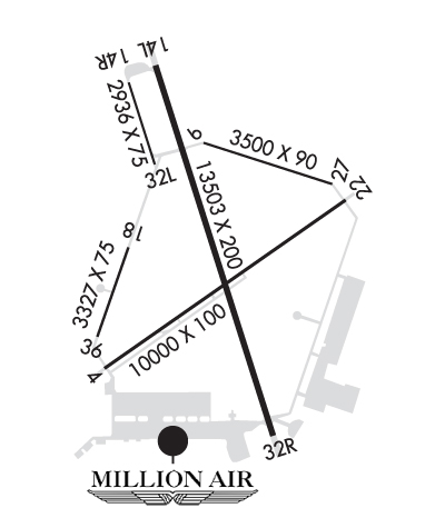
| Lat: N 4712.5 Long: W 11919.1 Elev: 1189 Var: -18 Longest Runway: 13503 | ||
| Dept. ATIS: 119.05 Arr. ATIS: 119.05 Ground: 121.9 Tower: 118.25/128.0 | ||
| |||||||||||||||||||||||||||||||||||||||||||||||||||||||||||||||||||||
| |||||||||||||||||||||||||||||||||||||||||||||||||||||||||||||||||||||
| |||||||||||||||||||||||||||||||||||||||||||||||||||||||||||||||||||||
| |||||||||||||||||||||||||||||||||||||||||||||||||||||||||||||||||||||
| Rwy | Rwy | |||||||
| 10000x100 | 10000' | 10000x100 | 10000' | |||||
| 3500x90 | 3500' | 3500x90 | 3500' | |||||
| 13503x200 | 13503' | 13503x200 | 13503' | 109.50 - 324° | ||||
| 2936x75 | 2936' | 2936x75 | 2936' | |||||
| 3327x75 | 3327' | 3327x75 | 3327' | |||||
| Runway ID | Single Wheel | Double Wheel | Double Tandem Wheel | Dual Double Wheel |
| 04/22 | 75,000 | 100,000 | 175,000 | 475,000 |
| 09/27 | 100,000 | 150,000 | 270,000 | 475,000 |
| 14L/32R | 85,000 | 155,000 | 320,000 | 600,000 |
| 14R/32L | 100,000 | 200,000 | 400,000 | 400,000 |
| 18/36 | 75,000 | 170,000 | 300,000 | 400,000 |
| These numbers are Advisory and are not limits. The Airport Manager should have more accurate Weight Limits | ||||
 Airport Diagram might not be current. | |
| Facility Name: | GRANT COUNTY INTL |
| City Name: | MOSES LAKE |
| County: | GRANT |
| State abbrev: | WA |
| State Name: | WASHINGTON |
| Ownership: | PUBLICLY OWNED |
| Use: | OPEN TO THE PUBLIC |
| Owner's Name: | PORT OF MOSES LAKE |
| Address: | 7810 ANDREWS STREET NE |
| MOSES LAKE, WA 98837 | |
| Owner's Phone: | 509-762-5363 |
| Manager's Name: | RICH MUELLER; AIRPORT DIRECTOR |
| Address: | 7810 ANDREWS STREET NE |
| MOSES LAKE, WA 98837-3204 | |
| Phone: | 509-762-5363 |
| FAA Region: | NORTHWEST MOUNTAIN |
| FAA Field Office: | SEA |

| Date | Sunrise | Sunset |
|---|---|---|
| 09/24/21 Friday | 6:46 | 18:51 |
| 09/25/21 Saturday | 6:48 | 18:49 |
| 09/26/21 Sunday | 6:49 | 18:47 |
| 09/27/21 Monday | 6:51 | 18:45 |
| 09/28/21 Tuesday | 6:52 | 18:43 |
| 09/29/21 Wednesday | 6:53 | 18:41 |
| 09/30/21 Thursday | 6:55 | 18:39 |
| 10/01/21 Friday | 6:56 | 18:37 |
| 10/02/21 Saturday | 6:57 | 18:35 |
| 10/03/21 Sunday | 6:59 | 18:33 |
| 10/04/21 Monday | 7:00 | 18:31 |
| 10/05/21 Tuesday | 7:01 | 18:29 |
| 10/06/21 Wednesday | 7:03 | 18:27 |
| 10/07/21 Thursday | 7:04 | 18:25 |
| Airport Attendance Schedule | CONTINUOUS |
| Airport Status | OPERATIONAL (This Status can change at any time - please check NOTAMS) |
| Airport Lighting Schedule | ACTVT MALSR RWY 32R; REIL RWY 4; PAPI RWY 14L - CTAF. |
| Airport Storage Available | Tie Downs, Hanger |
| Extra Services Available | Air Freight, Cargo Handling, Charter, Aircraft Rental |
| Wind Indicator | YES - (lighted) |
| Control Tower | YES |
| CTAF Frequency | 118.250 |
| Unicom Frequency | 122.950 |
| Rotating Beacon Color | CLEAR-GREEN (Light Land Airport) |
| Segmented Circle | YES |
| Landing Fee | YES; LANDING FEES FOR ACFT OVER 12,500. |
| Airport Inspected | FEDERAL - performed by FAA AIRPORTS FIELD PERSONNEL |
| Inspection Date | 09/21/2018 |
| Type of Fuel Available | Grade 100LL, JET A (freeze point -40C), JET A-1 (icing inhibitor, freeze point -50C) |
| Airframe Repair Service | MAJOR |
| Power Plant Repair Service | MAJOR |
| Latitude | N4712.5 |
| Longitude | W11919.1 (ESTIMATED) |
| Arpt Elevation | 1188ft (SURVEYED) |
| Magnetic Variation | 18E |
| 5 miles NW | of MOSES LAKE |
| Traffic Pattern Altitude | |
| Sectional Chart | SEATTLE |
| Operations (Reported) | Yearly | Avg. Daily |
|---|---|---|
| General Aviation Transient | 12288 | 34 |
| General Aviation Local | 34821 | 95 |
| Air Taxi | 11028 | 30 |
| Commerical | 7468 | 20 |
| Commuter | 0 | 0 |
| Military | 11730 | 32 |
| Aircraft based on Field | |
|---|---|
| General Aviation Singles | 40 |
| General Aviation Multi | 5 |
| Jet Aircraft | 0 |
| General Aviation Helicopters | 0 |
| Military Aircraft | 0 |
| Gliders | 0 |
| Ultralights | 0 |
| FSS on field | NO |
| FSS tie-in | SEATTLE |
| FSS Phone | 1-800-WX-BRIEF |
| Who issues Notams | MWH |
| Notam D service at airport | YES |
| ARTCC Name | SEATTLE |
| Airport Certification | PPR FOR ACR OPNS WITH MORE THAN 30 PAX SEATS 2200-0600 509-762-5363. ARFF DEP STAFFED AND EQPTD AT INDEX D 24/7. |
| Aircraft Rescue & Firefighting Index | AIRPORT HAS A CERTIFICATE UNDER CFR PART 139 |
| Airport of Entry | No |
| Custom Landing Rights | No; US CUSTOMS USER FEE ARPT. |
| Joint Civil/Military | No |
| Military Landing rights | YES |
| NATIONAL PLAN OF INTEGRATED AIRPORT SYSTEMS (NPIAS) |
| GRANT AGREEMENTS UNDER FAAP/ADAP/AIP |
| SURPLUS PROPERTY AGREEMENT UNDER PUBLIC LAW 289 |
| ASSURANCES PURSUANT TO TITLE VI, CIVIL RIGHTS ACT OF 1964 |
| FLOCKS OF LRG BIRDS INVOF ARPT APRIL AND OCTOBER |
| HVY JET TRNG SFC TO 5000 FT WI 25 MI OF ARPT; PSBL WAKE TURBC FM LARGER ACFT USING RY 14L/32R AND RY 9/27. |
| RY 18/36 AVBL AS AIR CARRIER TWY MOVEMENT AREA ONLY. |
| TWY G UNLGTD. |
| RY 09/27 USED AS ASSAULT STRIP BY C-17 ACFT. |
| EXTENSIVE HVY MIL JET ACFT NIGHT TRAINING 1900PM-0300AM LCL DAILY. ANNOUNCE LANDING INTENTIONS ON CTAF AFTER ATCT CLSD. |
| RUNWAY 9-27 AND TAXIWAY FOXTROT NOT VISIBLE FROM THE ATCT. |
| RWY 09/2 7 RY 9/27 CLSD EXC MIL OPERATIONS. |
| RWY 14L/ 32RRY 14L/32R CLSD NGTS 2200-0600 EXCEPT FOR SPECIAL MILITARY NGT TRAINING OPS. |
| RWY 14R/ 32LRY 14R/32L IS CLOSED TO ALL NIGHT OPERATIONS EXCEPT TAXIING. |
| RWY 14L/ 32RFIRST 10000 FT AER 32R GRVD 150 FT WIDE. |
| RWY 09/2 7 MIL LNDG ZONE LGTS ONLY. |
| RWY 14L/ 32RRY 14L/32R NSTD HIRL LCTD 50 FT FM RY EDGE MARKINGS. |
Airport Communications & Frequencies:
| |||||||||||||||||||||||||||||||||||||||
| Runway: 04 | Runway: 22 | ||
| Mag heading: | 36° | Mag heading: | 216° |
| Rwy Slope: | -.35% Down | Rwy Slope: | .35% Up |
| Approach: | Approach: | ||
| Pattern: | Left Traffic | Pattern: | Right Traffic |
| Markings: | NONPRECISION INSTRUMENT | Markings: | NONPRECISION INSTRUMENT |
| Marking Condition: | GOOD | Marking Condition: | GOOD |
| Arresting Dev: | Arresting Dev: | ||
| Lat & Long: | N4711.8 W11920.0 | Lat. & Long.: | N4712.8 W11918.0 |
| Elev: | 1188.6 ft. MSL | Elev: | 1153.4 ft. MSL |
| TCH: | 49 ft. AGL | TCH: | 50 ft. AGL |
| Visual Glide Path: | 3.00 degrees | Visual Glide Path: | 3.00 degrees |
| Displaced Threshold: | No | Displaced Threshold: | No |
| Touchdown Zone: | YES | Touchdown Zone: | YES |
| Touchdown Elev.: | 1188.6 feet | Touchdown Elev.: | 1165.6 feet |
| Visual Glide Slope: | 4-Light PAPI on LEFT side of Runway | Visual Glide Slope: | 4-BOX VASI ON LEFT SIDE OF RUNWAY |
| RVR Equipment: | RVR Equipment: | ||
| RVV Equipment: | NO | RVV Equipment: | NO |
| Approach Lights: | Approach Lights: | ||
| REIL: | YES | REIL: | YES |
| Centerline Lights: | NO | Centerline Lights: | NO |
| Touchdown lights: | NO | Touchdown lights: | NO |
| Runway Category: | Runway with a Non-precision Approach having visibility minimums greater than 3/4 mile | Runway Category: | Runway with a Non-precision Approach having visibility minimums greater than 3/4 mile |
| Declared Distances: | TORA:10000' TODA:10000' ASDA:10000' LDA:10000' | Declared Distances: | TORA:10000' TODA:10000' ASDA:10000' LDA:10000' |
| Runway: 09 | Runway: 27 | ||
| Mag heading: | 90° | Mag heading: | 270° |
| Rwy Slope: | -.27% Down | Rwy Slope: | .27% Up |
| Approach: | Approach: | ||
| Pattern: | Left Traffic | Pattern: | Right Traffic |
| Markings: | Markings: | ||
| Marking Condition: | Marking Condition: | ||
| Arresting Dev: | Arresting Dev: | ||
| Lat & Long: | N4713.1 W11919.0 | Lat. & Long.: | N4712.9 W11918.2 |
| Elev: | 1162.2 ft. MSL | Elev: | 1152.9 ft. MSL |
| TCH: | TCH: | ||
| Visual Glide Path: | Visual Glide Path: | ||
| Displaced Threshold: | No | Displaced Threshold: | No |
| Touchdown Zone: | YES | Touchdown Zone: | YES |
| Touchdown Elev.: | 1162.2 feet | Touchdown Elev.: | 1160.2 feet |
| Visual Glide Slope: | Visual Glide Slope: | ||
| RVR Equipment: | RVR Equipment: | ||
| RVV Equipment: | NO | RVV Equipment: | NO |
| Approach Lights: | Approach Lights: | ||
| REIL: | NO | REIL: | NO |
| Centerline Lights: | NO | Centerline Lights: | NO |
| Touchdown lights: | NO | Touchdown lights: | NO |
| Runway Category: | Runway with a Visual Approach | Runway Category: | Runway with a Visual Approach |
| Declared Distances: | TORA:3500' TODA:3500' ASDA:3500' LDA:3500' | Declared Distances: | TORA:3500' TODA:3500' ASDA:3500' LDA:3500' |
| Runway: 14L | Runway: 32R | ||
| Mag heading: | 144° | Mag heading: | 324° |
| Rwy Slope: | -.01% Down | Rwy Slope: | .01% Up |
| Approach: | Approach: | ILS | |
| Pattern: | Left Traffic | Pattern: | Right Traffic |
| Markings: | PRECISION INSTRUMENT | Markings: | PRECISION INSTRUMENT |
| Marking Condition: | GOOD | Marking Condition: | GOOD |
| Arresting Dev: | Arresting Dev: | ||
| Lat & Long: | N4713.5 W11919.6 | Lat. & Long.: | N4711.4 W11918.6 |
| Elev: | 1168.4 ft. MSL | Elev: | 1166.5 ft. MSL |
| TCH: | 75 ft. AGL | TCH: | 76 ft. AGL |
| Visual Glide Path: | 3.00 degrees | Visual Glide Path: | 3.00 degrees |
| Displaced Threshold: | No | Displaced Threshold: | No |
| Touchdown Zone: | YES | Touchdown Zone: | YES |
| Touchdown Elev.: | 1169.2 feet | Touchdown Elev.: | 1167.3 feet |
| Visual Glide Slope: | 4-Light PAPI on LEFT side of Runway | Visual Glide Slope: | 4-Light PAPI on LEFT side of Runway |
| RVR Equipment: | RVR Equipment: | ||
| RVV Equipment: | NO | RVV Equipment: | YES |
| Approach Lights: | Approach Lights: | MALSR - 1,400 foot medium intensity approach lighting system with runway alignment indicator lights | |
| REIL: | YES | REIL: | NO |
| Centerline Lights: | NO | Centerline Lights: | NO |
| Touchdown lights: | NO | Touchdown lights: | NO |
| Runway Category: | Runway with a Non-precision Approach having visibility minimums greater than 3/4 mile | Runway Category: | Precision Instrument Runway |
| Declared Distances: | TORA:13503' TODA:13503' ASDA:13503' LDA:13503' | Declared Distances: | TORA:13503' TODA:13503' ASDA:13492' LDA:13492' |
| Obstructions: | BLDG | Obstructions: | |
| Marked: | MARKED and LIGHTED | Marked: | |
| Clearance slope: | 35:1 | Clearance slope: | 50:1 |
| Obstruction height: | 25 feet AGL | Obstruction height: | |
| Dist. from runway: | 1081 feet | Dist. from runway: | |
| Centerline offset: | Centerline offset: | ||
| Comments: | Comments: |
| Runway: 14R | Runway: 32L | ||
| Mag heading: | 144° | Mag heading: | 324° |
| Rwy Slope: | .06% Up | Rwy Slope: | -.06% Down |
| Approach: | Approach: | ||
| Pattern: | Right Traffic | Pattern: | Left Traffic |
| Markings: | BASIC | Markings: | BASIC |
| Marking Condition: | GOOD | Marking Condition: | GOOD |
| Arresting Dev: | Arresting Dev: | ||
| Lat & Long: | N4713.4 W11919.8 | Lat. & Long.: | N4713.0 W11919.6 |
| Elev: | 1167.8 ft. MSL | Elev: | 1169.6 ft. MSL |
| TCH: | TCH: | ||
| Visual Glide Path: | Visual Glide Path: | ||
| Displaced Threshold: | No | Displaced Threshold: | No |
| Touchdown Zone: | YES | Touchdown Zone: | YES |
| Touchdown Elev.: | 1169.6 feet | Touchdown Elev.: | 1169.6 feet |
| Visual Glide Slope: | Visual Glide Slope: | ||
| RVR Equipment: | RVR Equipment: | ||
| RVV Equipment: | NO | RVV Equipment: | NO |
| Approach Lights: | Approach Lights: | ||
| REIL: | NO | REIL: | NO |
| Centerline Lights: | NO | Centerline Lights: | NO |
| Touchdown lights: | NO | Touchdown lights: | NO |
| Runway Category: | Runway with a Visual Approach | Runway Category: | Runway with a Visual Approach |
| Declared Distances: | TORA:2936' TODA:2936' ASDA:2936' LDA:2936' | Declared Distances: | TORA:2936' TODA:2936' ASDA:2936' LDA:2936' |
| Obstructions: | GND | Obstructions: | |
| Marked: | NOT Marked/Lighted | Marked: | |
| Clearance slope: | 46:1 | Clearance slope: | 50:1 |
| Obstruction height: | 9 feet AGL | Obstruction height: | |
| Dist. from runway: | 620 feet | Dist. from runway: | |
| Centerline offset: | 100 right of centerline | Centerline offset: | |
| Comments: | Comments: |
| Runway: 18 | Runway: 36 | ||
| Mag heading: | 180° | Mag heading: | 0° |
| Rwy Slope: | -.01% Down | Rwy Slope: | .01% Up |
| Approach: | Approach: | ||
| Pattern: | Right Traffic | Pattern: | Left Traffic |
| Markings: | BASIC | Markings: | BASIC |
| Marking Condition: | GOOD | Marking Condition: | GOOD |
| Arresting Dev: | Arresting Dev: | ||
| Lat & Long: | N4712.5 W11919.8 | Lat. & Long.: | N4712.0 W11920.0 |
| Elev: | 1185.1 ft. MSL | Elev: | 1184.8 ft. MSL |
| TCH: | TCH: | ||
| Visual Glide Path: | Visual Glide Path: | ||
| Displaced Threshold: | No | Displaced Threshold: | No |
| Touchdown Zone: | YES | Touchdown Zone: | YES |
| Touchdown Elev.: | 1185.1 feet | Touchdown Elev.: | 1185.1 feet |
| Visual Glide Slope: | Visual Glide Slope: | ||
| RVR Equipment: | RVR Equipment: | ||
| RVV Equipment: | NO | RVV Equipment: | NO |
| Approach Lights: | Approach Lights: | ||
| REIL: | NO | REIL: | NO |
| Centerline Lights: | NO | Centerline Lights: | NO |
| Touchdown lights: | NO | Touchdown lights: | NO |
| Runway Category: | Runway with a Visual Approach | Runway Category: | Runway with a Visual Approach |
| Declared Distances: | Declared Distances: |
Thanks for using FltPlan.com
all rights reserved © 1999-2021 by Flight Plan LLC