
| LAWRENCE J TIMMERMAN MILWAUKEE WI |
| |
| Lat: N 4306.6 Long: W 08802.1 Elev: 745 Var: +02 Longest Runway: 4107 | ||
| Clr Del: 121.7 TWR CLD Dept. ATIS: 128.3 Arr. ATIS: 128.3 Ground: 121.7 Tower: 120.5 | ||
| ||||||||||||||||||||||||||||||||||||||||||||
| ||||||||||||||||||||||||||||||||||||||||||||
| ||||||||||||||||||||||||||||||||||||||||||||
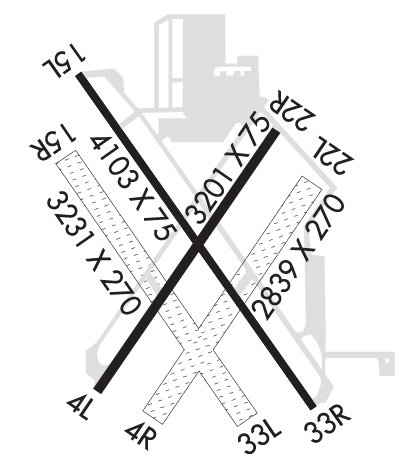
| Rwy | Rwy | |||||||
| 3203x75 | 3203' | 3203x75 | 3203' | |||||
| 2840x270 | 2840' | 2840x270 | 2840' | |||||
| 4107x75 | 4107' | 108.50 - 147° | 4107x75 | 4107' | ||||
| 3231x270 | 3231' | 3231x270 | 3231' | |||||
| Runway ID | Single Wheel | Double Wheel | Double Tandem Wheel | Dual Double Wheel |
| 04L/22R | 30,000 | N/A | N/A | N/A |
| 04R/22L | N/A | N/A | N/A | N/A |
| 15L/33R | 30,000 | N/A | N/A | N/A |
| 15R/33L | N/A | N/A | N/A | N/A |
| These numbers are Advisory and are not limits. The Airport Manager should have more accurate Weight Limits | ||||
 Airport Diagram might not be current. | |
| Facility Name: | LAWRENCE J TIMMERMAN |
| City Name: | MILWAUKEE |
| County: | MILWAUKEE |
| State abbrev: | WI |
| State Name: | WISCONSIN |
| Ownership: | PUBLICLY OWNED |
| Use: | OPEN TO THE PUBLIC |
| Owner's Name: | MILWAUKEE COUNTY |
| Address: | COUNTY COURTHOUSE |
| MILWAUKEE, WI 53233 | |
| Owner's Phone: | 414-747-5300 |
| Manager's Name: | BRIAN DRANZIK |
| Address: | 5300 S HOWELL; EMAIL ADDRESS: BDRANZIK@MITCHELLAIRPORT.COM (ALL LOWER CASE) |
| MILWAUKEE, WI 53207 | |
| Phone: | 414-747-5775 |
| FAA Region: | GREAT LAKES |
| FAA Field Office: | CHI |
| Date | Sunrise | Sunset |
|---|---|---|
| 06/12/26 Friday | 5:12 | 20:32 |
| 06/13/26 Saturday | 5:12 | 20:32 |
| 06/14/26 Sunday | 5:12 | 20:33 |
| 06/15/26 Monday | 5:12 | 20:33 |
| 06/16/26 Tuesday | 5:12 | 20:34 |
| 06/17/26 Wednesday | 5:12 | 20:34 |
| 06/18/26 Thursday | 5:12 | 20:34 |
| 06/19/26 Friday | 5:12 | 20:35 |
| 06/20/26 Saturday | 5:12 | 20:35 |
| 06/21/26 Sunday | 5:13 | 20:35 |
| 06/22/26 Monday | 5:13 | 20:35 |
| 06/23/26 Tuesday | 5:13 | 20:36 |
| 06/24/26 Wednesday | 5:13 | 20:36 |
| 06/25/26 Thursday | 5:14 | 20:36 |
| Airport Attendance Schedule | 7 Days A Week 0800-1600 |
| Airport Status | OPERATIONAL (This Status can change at any time - please check NOTAMS) |
| Airport Lighting Schedule | WHEN ATCT CLSD, MIRL RWY 15L/33R PRESET TO LOW SS-SR; TO INCR INTST AND ACTVT REIL RWY 04L, 15L, 22R, & 33R; PAPI RWY 15L & 33R; VASI RWY 04L & 22R; AND MIRL RWY 04L/22R - CTAF. |
| Airport Storage Available | Tie Downs, Hanger |
| Extra Services Available | Charter, Flight Instruction, Aircraft Rental, Aircraft Sales |
| Wind Indicator | YES - (unlit) |
| Control Tower | YES |
| CTAF Frequency | 120.500 |
| Unicom Frequency | 122.950 |
| Rotating Beacon Color | WG |
| Segmented Circle | NO |
| Landing Fee | NO |
| Airport Inspected | STATE - performed by STATE AERONAUTICAL PERSONNEL |
| Inspection Date | 06/28/2023 |
| Type of Fuel Available | Grade 100LL, JET A |
| Airframe Repair Service | MAJOR |
| Power Plant Repair Service | MAJOR |
| Latitude | N4306.6 |
| Longitude | W08802.1 (ESTIMATED) |
| Arpt Elevation | 744ft (SURVEYED) |
| Magnetic Variation | 02W |
| 5 miles NW | of MILWAUKEE |
| Traffic Pattern Altitude | |
| Sectional Chart | CHICAGO |
| Operations (Reported) | Yearly | Avg. Daily |
|---|---|---|
| General Aviation Transient | 0 | 0 |
| General Aviation Local | 0 | 0 |
| Air Taxi | 0 | 0 |
| Commerical | 0 | 0 |
| Commuter | 0 | 0 |
| Military | 0 | 0 |
| Aircraft based on Field | |
|---|---|
| General Aviation Singles | 0 |
| General Aviation Multi | 0 |
| Jet Aircraft | 0 |
| General Aviation Helicopters | 0 |
| Military Aircraft | 0 |
| Gliders | 0 |
| Ultralights | 0 |
| FSS on field | NO |
| FSS tie-in | GREEN BAY |
| FSS Phone | 1-800-WX-BRIEF |
| Who issues Notams | MWC |
| Notam D service at airport | YES |
| ARTCC Name | CHICAGO |
| Airport Certification | |
| Aircraft Rescue & Firefighting Index | None |
| Airport of Entry | No |
| Custom Landing Rights | No |
| Joint Civil/Military | No |
| Military Landing rights | YES |
| NATIONAL PLAN OF INTEGRATED AIRPORT SYSTEMS (NPIAS) |
| GRANT AGREEMENTS UNDER FAAP/ADAP/AIP |
| ASSURANCES PURSUANT TO TITLE VI, CIVIL RIGHTS ACT OF 1964 |
| BCN ELEV 797' MSL. |
| TURF RYS 04R/22L & 15R/33L & ALL TURF TWYS CLSD 15 OCT - 1 MAY. |
| BIRDS ON & INVOF ARPT. |
| CONDS UNMON MON-FRI 1530-0630, SAT, SUN, OR FED HOLS. |
| DO NOT MISTAKE TWY B & C FOR LDG/TKOF SFCS. |
| LOSS OF RDO RECEPTION OCRS IN & ARND HNGRS N OF N RAMP. ACFT SHOULD REPOSITION TO N RAMP TO RCV CLNC & TAXI INSTRS. |
Airport Communications & Frequencies:
| ||||||||||||||||||||||
| Runway: 04L | Runway: 22R | ||
| Mag heading: | 38° | Mag heading: | 218° |
| Rwy Slope: | .04% Up | Rwy Slope: | -.04% Down |
| Approach: | Approach: | ||
| Pattern: | Left Traffic | Pattern: | Left Traffic |
| Markings: | NONPRECISION INSTRUMENT | Markings: | NONPRECISION INSTRUMENT |
| Marking Condition: | GOOD | Marking Condition: | GOOD |
| Arresting Dev: | Arresting Dev: | ||
| Lat & Long: | N4306.4 W08802.3 | Lat. & Long.: | N4306.9 W08801.9 |
| Elev: | 737.2 ft. MSL | Elev: | 738.4 ft. MSL |
| TCH: | 44 ft. AGL | TCH: | 45 ft. AGL |
| Visual Glide Path: | 4.00 degrees | Visual Glide Path: | 4.00 degrees |
| Displaced Threshold: | No | Displaced Threshold: | No |
| Touchdown Zone: | YES | Touchdown Zone: | YES |
| Touchdown Elev.: | 738.0 feet | Touchdown Elev.: | 738.4 feet |
| Visual Glide Slope: | 4-BOX VASI ON LEFT SIDE OF RUNWAY; WHEN VASI OTS, RWY CLSD TO LDG SS-SR. | Visual Glide Slope: | 4-BOX VASI ON LEFT SIDE OF RUNWAY; WHEN VASI OTS, RWY CLSD TO LDG SS-SR. |
| RVR Equipment: | RVR Equipment: | ||
| RVV Equipment: | NO | RVV Equipment: | NO |
| Approach Lights: | Approach Lights: | ||
| REIL: | YES | REIL: | YES |
| Centerline Lights: | NO | Centerline Lights: | NO |
| Touchdown lights: | NO | Touchdown lights: | NO |
| Runway Category: | Runway with a Non-precision Approach | Runway Category: | Runway with a Non-precision Approach |
| Declared Distances: | Declared Distances: | ||
| Obstructions: | Obstructions: | TREE | |
| Marked: | Marked: | NOT Marked/Lighted | |
| Clearance slope: | 20:1 | Clearance slope: | 17:1 |
| Obstruction height: | Obstruction height: | 29 feet AGL | |
| Dist. from runway: | Dist. from runway: | 700 feet | |
| Centerline offset: | Centerline offset: | 250 feet left of centerline | |
| Comments: | Comments: |
| Runway: 04R | Runway: 22L | ||
| Mag heading: | 38° | Mag heading: | 218° |
| Rwy Slope: | .15% Up | Rwy Slope: | -.15% Down |
| Approach: | Approach: | ||
| Pattern: | Left Traffic | Pattern: | Left Traffic |
| Markings: | Markings: | ||
| Marking Condition: | MKD BY WHITE TFC CONES. | Marking Condition: | MKD BY WHITE TFC CONES. |
| Arresting Dev: | Arresting Dev: | ||
| Lat & Long: | N4306.4 W08802.2 | Lat. & Long.: | N4306.8 W08801.8 |
| Elev: | 732.0 ft. MSL | Elev: | 736.4 ft. MSL |
| TCH: | TCH: | ||
| Visual Glide Path: | Visual Glide Path: | ||
| Displaced Threshold: | No | Displaced Threshold: | No |
| Touchdown Zone: | YES | Touchdown Zone: | YES |
| Touchdown Elev.: | 736.4 feet | Touchdown Elev.: | 736.4 feet |
| Visual Glide Slope: | Visual Glide Slope: | ||
| RVR Equipment: | RVR Equipment: | ||
| RVV Equipment: | NO | RVV Equipment: | NO |
| Approach Lights: | Approach Lights: | ||
| REIL: | NO | REIL: | NO |
| Centerline Lights: | NO | Centerline Lights: | NO |
| Touchdown lights: | NO | Touchdown lights: | NO |
| Runway Category: | Runway with a Visual Approach | Runway Category: | Runway with a Visual Approach |
| Declared Distances: | Declared Distances: | ||
| Obstructions: | TREES | Obstructions: | TREES |
| Marked: | NOT Marked/Lighted | Marked: | NOT Marked/Lighted |
| Clearance slope: | 14:1 | Clearance slope: | 15:1 |
| Obstruction height: | 50 feet AGL | Obstruction height: | 53 feet AGL |
| Dist. from runway: | 915 feet | Dist. from runway: | 800 feet |
| Centerline offset: | Centerline offset: | 150 feet left of centerline | |
| Comments: | Comments: |
| Runway: 15L | Runway: 33R | ||
| Mag heading: | 148° | Mag heading: | 328° |
| Rwy Slope: | -.01% Down | Rwy Slope: | .01% Up |
| Approach: | LOCALIZER | Approach: | |
| Pattern: | Left Traffic | Pattern: | Left Traffic |
| Markings: | NONPRECISION INSTRUMENT | Markings: | NONPRECISION INSTRUMENT |
| Marking Condition: | GOOD | Marking Condition: | GOOD |
| Arresting Dev: | Arresting Dev: | ||
| Lat & Long: | N4306.9 W08802.3 | Lat. & Long.: | N4306.4 W08801.8 |
| Elev: | 744.1 ft. MSL | Elev: | 743.7 ft. MSL |
| TCH: | 41 ft. AGL | TCH: | 40 ft. AGL |
| Visual Glide Path: | 3.00 degrees | Visual Glide Path: | 4.00 degrees |
| Displaced Threshold: | No | Displaced Threshold: | No |
| Touchdown Zone: | YES | Touchdown Zone: | YES |
| Touchdown Elev.: | 744.8 feet | Touchdown Elev.: | 743.7 feet |
| Visual Glide Slope: | 4-Light PAPI on RIGHT side of Runway | Visual Glide Slope: | 4-Light PAPI on LEFT side of Runway; UNUSBL BYD 8 DEGS RIGHT OF CNTRLN. WHEN PAPI OTS, RWY CLSD TO LDG SS-SR. |
| RVR Equipment: | RVR Equipment: | ||
| RVV Equipment: | NO | RVV Equipment: | NO |
| Approach Lights: | Approach Lights: | ||
| REIL: | YES | REIL: | YES |
| Centerline Lights: | NO | Centerline Lights: | NO |
| Touchdown lights: | NO | Touchdown lights: | NO |
| Runway Category: | Runway with a Non-precision Approach having visibility minimums greater than 3/4 mile | Runway Category: | Runway with a Visual Approach |
| Declared Distances: | Declared Distances: | ||
| Obstructions: | Obstructions: | TREE | |
| Marked: | Marked: | NOT Marked/Lighted | |
| Clearance slope: | 34:1 | Clearance slope: | 18:1 |
| Obstruction height: | Obstruction height: | 35 feet AGL | |
| Dist. from runway: | Dist. from runway: | 830 feet | |
| Centerline offset: | Centerline offset: | 25 feet right of centerline | |
| Comments: | Comments: |
| Runway: 15R | Runway: 33L | ||
| Mag heading: | 147° | Mag heading: | 327° |
| Rwy Slope: | -.28% Down | Rwy Slope: | .28% Up |
| Approach: | Approach: | ||
| Pattern: | Left Traffic | Pattern: | Left Traffic |
| Markings: | Markings: | ||
| Marking Condition: | MKD BY WHITE TFC CONES. | Marking Condition: | MKD BY WHITE TFC CONES. |
| Arresting Dev: | Arresting Dev: | ||
| Lat & Long: | N4306.8 W08802.4 | Lat. & Long.: | N4306.4 W08801.9 |
| Elev: | 742.3 ft. MSL | Elev: | 733.3 ft. MSL |
| TCH: | TCH: | ||
| Visual Glide Path: | Visual Glide Path: | ||
| Displaced Threshold: | No | Displaced Threshold: | No |
| Touchdown Zone: | YES | Touchdown Zone: | YES |
| Touchdown Elev.: | 742.5 feet | Touchdown Elev.: | 742.2 feet |
| Visual Glide Slope: | Visual Glide Slope: | ||
| RVR Equipment: | RVR Equipment: | ||
| RVV Equipment: | NO | RVV Equipment: | NO |
| Approach Lights: | Approach Lights: | ||
| REIL: | NO | REIL: | NO |
| Centerline Lights: | NO | Centerline Lights: | NO |
| Touchdown lights: | NO | Touchdown lights: | NO |
| Runway Category: | Runway with a Visual Approach | Runway Category: | Runway with a Visual Approach |
| Declared Distances: | Declared Distances: | ||
| Obstructions: | Obstructions: | TREE | |
| Marked: | Marked: | NOT Marked/Lighted | |
| Clearance slope: | 20:1 | Clearance slope: | 16:1 |
| Obstruction height: | Obstruction height: | 50 feet AGL | |
| Dist. from runway: | Dist. from runway: | 800 feet | |
| Centerline offset: | Centerline offset: | 50 feet left of centerline | |
| Comments: | Comments: |
Thanks for using FltPlan.com
all rights reserved © 1999-2026 by Flight Plan LLC
