
| MOUNT VERNON MOUNT VERNON IL |
| |
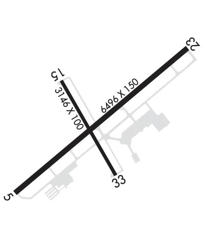
| Lat: N 3819.4 Long: W 08851.5 Elev: 480 Var: +01 Longest Runway: 6496 | ||
| AWOS: 113.8 CTAF: 123.0 | ||
| ||||||||||||||||||||||||||||||||||||||||||||
| ||||||||||||||||||||||||||||||||||||||||||||
| ||||||||||||||||||||||||||||||||||||||||||||
| Rwy | Rwy | |||||||
| 6496x150 | 5722' | 6496x150 | 6496' | 111.70 - 231° | ||||
| 3146x100 | 3146' | 3146x100 | 3146' | |||||
| Runway ID | Single Wheel | Double Wheel | Double Tandem Wheel | Dual Double Wheel |
| 05/23 | 120,000 | 177,000 | 238,000 | 678,000 |
| 15/33 | 55,000 | 72,000 | 121,000 | N/A |
| H1 | N/A | N/A | N/A | N/A |
| These numbers are Advisory and are not limits. The Airport Manager should have more accurate Weight Limits | ||||
 Airport Diagram might not be current. | |
| Facility Name: | MOUNT VERNON |
| City Name: | MOUNT VERNON |
| County: | JEFFERSON |
| State abbrev: | IL |
| State Name: | ILLINOIS |
| Ownership: | PUBLICLY OWNED |
| Use: | OPEN TO THE PUBLIC |
| Owner's Name: | MT VERNON ARPT AUTHORITY |
| Address: | 100 AVIATION DRIVE |
| MT VERNON, IL 62864 | |
| Owner's Phone: | 618-242-7016 |
| Manager's Name: | CHRIS COLLINS |
| Address: | 100 AVIATION DRIVE |
| MT VERNON, IL 62864 | |
| Phone: | 618-242-7016 |
| FAA Region: | GREAT LAKES |
| FAA Field Office: | CHI |
| Date | Sunrise | Sunset |
|---|---|---|
| 06/08/26 Monday | 5:32 | 20:17 |
| 06/09/26 Tuesday | 5:32 | 20:18 |
| 06/10/26 Wednesday | 5:31 | 20:18 |
| 06/11/26 Thursday | 5:31 | 20:19 |
| 06/12/26 Friday | 5:31 | 20:19 |
| 06/13/26 Saturday | 5:31 | 20:20 |
| 06/14/26 Sunday | 5:31 | 20:20 |
| 06/15/26 Monday | 5:31 | 20:21 |
| 06/16/26 Tuesday | 5:31 | 20:21 |
| 06/17/26 Wednesday | 5:31 | 20:21 |
| 06/18/26 Thursday | 5:31 | 20:22 |
| 06/19/26 Friday | 5:32 | 20:22 |
| 06/20/26 Saturday | 5:32 | 20:22 |
| 06/21/26 Sunday | 5:32 | 20:22 |
| Airport Attendance Schedule | 7 Days A Week 0630-2000; FOR SVCS AFT HRS CALL 618-315-5462. |
| Airport Status | OPERATIONAL (This Status can change at any time - please check NOTAMS) |
| Airport Lighting Schedule | ACTVT MALSR RY 23 - CTAF. ACTVT MIRL RY 15/33 & HIRL RY 05/23 - CTAF NIGHT ONLY. |
| Airport Storage Available | Tie Downs, Hanger |
| Extra Services Available | Cargo Handling, Charter, Flight Instruction, Aircraft Rental, Aircraft Sales |
| Wind Indicator | YES - (lighted) |
| Control Tower | NO |
| CTAF Frequency | 123.000 |
| Unicom Frequency | 123.000 |
| Rotating Beacon Color | WG |
| Segmented Circle | YES |
| Landing Fee | NO |
| Airport Inspected | FEDERAL - performed by FAA AIRPORTS FIELD PERSONNEL |
| Inspection Date | 02/25/2020 |
| Type of Fuel Available | Grade 100LL, JET A (freeze point -40C) |
| Airframe Repair Service | MAJOR |
| Power Plant Repair Service | MAJOR |
| Latitude | N3819.4 |
| Longitude | W08851.5 (ESTIMATED) |
| Arpt Elevation | 480ft (SURVEYED) |
| Magnetic Variation | 01W |
| 3 miles E | of MOUNT VERNON |
| Traffic Pattern Altitude | |
| Sectional Chart | ST LOUIS |
| Operations (Reported) | Yearly | Avg. Daily |
|---|---|---|
| General Aviation Transient | 0 | 0 |
| General Aviation Local | 0 | 0 |
| Air Taxi | 0 | 0 |
| Commerical | 0 | 0 |
| Commuter | 0 | 0 |
| Military | 0 | 0 |
| Aircraft based on Field | |
|---|---|
| General Aviation Singles | 0 |
| General Aviation Multi | 0 |
| Jet Aircraft | 0 |
| General Aviation Helicopters | 0 |
| Military Aircraft | 0 |
| Gliders | 0 |
| Ultralights | 0 |
| FSS on field | NO |
| FSS tie-in | SAINT LOUIS |
| FSS Phone | 1-800-WX-BRIEF |
| Who issues Notams | MVN |
| Notam D service at airport | YES |
| ARTCC Name | KANSAS CITY |
| Airport Certification | |
| Aircraft Rescue & Firefighting Index | AIRPORT HAS A CERTIFICATE UNDER CFR PART 139 |
| Airport of Entry | No |
| Custom Landing Rights | No |
| Joint Civil/Military | No |
| Military Landing rights | YES |
| NATIONAL PLAN OF INTEGRATED AIRPORT SYSTEMS (NPIAS) |
| GRANT AGREEMENTS UNDER FAAP/ADAP/AIP |
| ASSURANCES PURSUANT TO TITLE VI, CIVIL RIGHTS ACT OF 1964 |
| MIGRATORY WATERFOWL INVOF ARPT. |
| FOR CD CTC KANSAS CITY ARTCC AT 913-254-8508. |
| RWY 05/2 3 RWY 05/23 NOT AVBL FOR PART 121/PART 380 OPS WITH SKED PAX CARRYING OPS MORE THAN 9 PAX SEATS AND NON-SKED PAX CARRYING OPS MORE THAN 30 PAX SEATS. 90 DAY PPR FOR UNSKED ACR OPS GTR THAN 30 PAX SEATS - CALL AMGR. 618-242-7016 |
| RWY 15/3 3 RWY 15/33 NOT AVBL FOR PART 121/PART 380 OPS WITH SKED PAX CARRYING OPS MORE THAN 9 PAX SEATS AND NON-SKED PAX CARRYING OPS MORE THAN 30 PAX SEATS. 90 DAY PPR FOR UNSKED ACR OPS GTR THAN 30 PAX SEATS - CALL AMGR. 618-242-7016 |
| RWY H1 FOR PVT USE BY AIR-EVAC LIFETEAM ONLY. |
| RWY 05/2 3 PCR VALUE: 550/F/D/X/T |
| RWY 15/3 3 PCR VALUE: 220/F/D/X/T |
Airport Communications & Frequencies:
| |||||||||
| Runway: 05 | Runway: 23 | ||
| Mag heading: | 51° | Mag heading: | 231° |
| Rwy Slope: | .02% Up | Rwy Slope: | -.02% Down |
| Approach: | Approach: | ILS | |
| Pattern: | Left Traffic | Pattern: | Left Traffic |
| Markings: | PRECISION INSTRUMENT | Markings: | PRECISION INSTRUMENT |
| Marking Condition: | GOOD | Marking Condition: | GOOD |
| Arresting Dev: | Arresting Dev: | ||
| Lat & Long: | N3819.1 W08852.0 | Lat. & Long.: | N3819.8 W08851.0 |
| Elev: | 466.8 ft. MSL | Elev: | 467.8 ft. MSL |
| TCH: | 32 ft. AGL | TCH: | |
| Visual Glide Path: | 3.00 degrees | Visual Glide Path: | |
| Displaced Threshold: | 774 feet | Displaced Threshold: | No |
| Touchdown Zone: | YES | Touchdown Zone: | YES |
| Touchdown Elev.: | 469.6 feet | Touchdown Elev.: | 470.8 feet |
| Visual Glide Slope: | 4-BOX VASI ON LEFT SIDE OF RUNWAY | Visual Glide Slope: | |
| RVR Equipment: | RVR Equipment: | ||
| RVV Equipment: | NO | RVV Equipment: | NO |
| Approach Lights: | Approach Lights: | MALSR - 1,400 foot medium intensity approach lighting system with runway alignment indicator lights; RY 23 MALSR AVBL DALGT HRS. | |
| REIL: | NO | REIL: | NO |
| Centerline Lights: | NO | Centerline Lights: | NO |
| Touchdown lights: | NO | Touchdown lights: | NO |
| Runway Category: | Runway with a Non-precision Approach having visibility minimums greater than 3/4 mile | Runway Category: | Precision Instrument Runway |
| Declared Distances: | TORA:6496' TODA:6496' ASDA:6496' LDA:5722' | Declared Distances: | TORA:5572' TODA:5572' ASDA:5572' LDA:5572' |
| Obstructions: | ROAD; ALSO 18 FT RR 238 FT FM RY END 498 FT R OF CNTRLN 2:1 SLOPE. | Obstructions: | TREES |
| Marked: | NOT Marked/Lighted | Marked: | NOT Marked/Lighted |
| Clearance slope: | APCH RATIO TO DSPLCD THLD 34:1 OVR TREES 2583 FT FM DSPLCD THLD 158 FT R OF CNTRLN. | Clearance slope: | 28:1 |
| Obstruction height: | 12 feet AGL | Obstruction height: | 97 feet AGL |
| Dist. from runway: | 200 feet | Dist. from runway: | 2988 feet |
| Centerline offset: | 395 right of centerline | Centerline offset: | 54 feet left of centerline |
| Comments: | 12 FT ROAD 0-200 FT FM THLD 395 FT R TO 495 FT R OF CNTRLN. | Comments: |
| Runway: 15 | Runway: 33 | ||
| Mag heading: | 151° | Mag heading: | 331° |
| Rwy Slope: | -.74% Down | Rwy Slope: | .74% Up |
| Approach: | Approach: | ||
| Pattern: | Left Traffic | Pattern: | Left Traffic |
| Markings: | BASIC | Markings: | BASIC |
| Marking Condition: | FAIR | Marking Condition: | FAIR |
| Arresting Dev: | Arresting Dev: | ||
| Lat & Long: | N3819.6 W08851.7 | Lat. & Long.: | N3819.2 W08851.4 |
| Elev: | 480.4 ft. MSL | Elev: | 457.0 ft. MSL |
| TCH: | TCH: | ||
| Visual Glide Path: | Visual Glide Path: | ||
| Displaced Threshold: | No | Displaced Threshold: | No |
| Touchdown Zone: | YES | Touchdown Zone: | YES |
| Touchdown Elev.: | 480.4 feet | Touchdown Elev.: | 478.6 feet |
| Visual Glide Slope: | Visual Glide Slope: | ||
| RVR Equipment: | RVR Equipment: | ||
| RVV Equipment: | NO | RVV Equipment: | NO |
| Approach Lights: | Approach Lights: | ||
| REIL: | NO | REIL: | NO |
| Centerline Lights: | NO | Centerline Lights: | NO |
| Touchdown lights: | NO | Touchdown lights: | NO |
| Runway Category: | Runway with a Visual Approach | Runway Category: | Runway with a Visual Approach |
| Declared Distances: | TORA:3146' TODA:3146' ASDA:3146' LDA:3146' | Declared Distances: | TORA:3146' TODA:3146' ASDA:3146' LDA:3146' |
| Obstructions: | TREE | Obstructions: | RR |
| Marked: | NOT Marked/Lighted | Marked: | NOT Marked/Lighted |
| Clearance slope: | 10:1 | Clearance slope: | 19:1 |
| Obstruction height: | 63 feet AGL | Obstruction height: | 23 feet AGL |
| Dist. from runway: | 873 feet | Dist. from runway: | 613 feet |
| Centerline offset: | 180 left of centerline | Centerline offset: | 166 feet left of centerline |
| Comments: | Comments: |
Thanks for using FltPlan.com
all rights reserved © 1999-2026 by Flight Plan LLC
