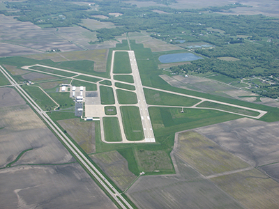
| COLES COUNTY MEMORIAL MATTOON/CHARLESTON IL |
| |
| Lat: N 3928.7 Long: W 08816.8 Elev: 722 Var: +03 Longest Runway: 6501 | ||
| AWOS: 109.4 CTAF: 122.7 | ||
| ||||||||||||||||||||||||||||||||
| ||||||||||||||||||||||||||||||||
| ||||||||||||||||||||||||||||||||
| ||||||||||||||||||||||||||||||||
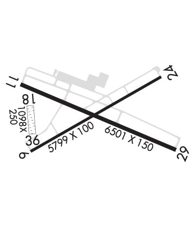
| Rwy | Rwy | |||||||
| 5799x100 | 5799' | 5799x100 | 5799' | |||||
| 6501x150 | 6501' | 6501x150 | 6501' | 111.10 - 295° | ||||
| 1098x250 | 1098' | 1098x250 | 1098' | |||||
| Runway ID | Single Wheel | Double Wheel | Double Tandem Wheel | Dual Double Wheel |
| 06/24 | 120,000 | 218,000 | 289,000 | 768,000 |
| 11/29 | 120,000 | 250,000 | 550,000 | 1,120,000 |
| 18/36 | N/A | N/A | N/A | N/A |
| These numbers are Advisory and are not limits. The Airport Manager should have more accurate Weight Limits | ||||
 Airport Diagram might not be current. | |
| Facility Name: | COLES COUNTY MEML |
| City Name: | MATTOON/CHARLESTON |
| County: | COLES |
| State abbrev: | IL |
| State Name: | ILLINOIS |
| Ownership: | PUBLICLY OWNED |
| Use: | OPEN TO THE PUBLIC |
| Owner's Name: | COLES COUNTY AIRPORT AUTHORITY |
| Address: | 432 AIRPORT ROAD |
| MATTOON, IL 61938 | |
| Owner's Phone: | 217-234-7120 |
| Manager's Name: | ANDREW FEARN |
| Address: | 432 AIRPORT ROAD |
| MATTOON, IL 61938 | |
| Phone: | 217-234-7120 |
| FAA Region: | GREAT LAKES |
| FAA Field Office: | CHI |
| Date | Sunrise | Sunset |
|---|---|---|
| 06/08/26 Monday | 5:26 | 20:19 |
| 06/09/26 Tuesday | 5:26 | 20:19 |
| 06/10/26 Wednesday | 5:26 | 20:20 |
| 06/11/26 Thursday | 5:25 | 20:20 |
| 06/12/26 Friday | 5:25 | 20:21 |
| 06/13/26 Saturday | 5:25 | 20:21 |
| 06/14/26 Sunday | 5:25 | 20:21 |
| 06/15/26 Monday | 5:25 | 20:22 |
| 06/16/26 Tuesday | 5:25 | 20:22 |
| 06/17/26 Wednesday | 5:25 | 20:23 |
| 06/18/26 Thursday | 5:26 | 20:23 |
| 06/19/26 Friday | 5:26 | 20:23 |
| 06/20/26 Saturday | 5:26 | 20:23 |
| 06/21/26 Sunday | 5:26 | 20:24 |
| Airport Attendance Schedule | APR-OCT M-F 0700-2000, NOV-MAR M-F 0700-1900, SAT-SUN 0700-1700 |
| Airport Status | OPERATIONAL (This Status can change at any time - please check NOTAMS) |
| Airport Lighting Schedule | ACTVT MALSR RWY 29; REIL RWY 06, 11 & 24; MIRL RWY 06/24 - CTAF. ACTVT HIRL RWY 11/29 & INCR INTST - CTAF. |
| Airport Storage Available | Tie Downs, Hanger |
| Extra Services Available | Air Freight, Crop Dusting, Air Ambulance, Cargo Handling, Charter, Flight Instruction, Aircraft Rental, Aircraft Sales |
| Wind Indicator | YES - (lighted) |
| Control Tower | NO |
| CTAF Frequency | 122.700 |
| Unicom Frequency | 122.700 |
| Rotating Beacon Color | WG |
| Segmented Circle | YES |
| Landing Fee | NO |
| Airport Inspected | FEDERAL - performed by FAA AIRPORTS FIELD PERSONNEL |
| Inspection Date | 11/12/2024 |
| Type of Fuel Available | Grade 100LL, JET A (freeze point -40C) |
| Airframe Repair Service | MAJOR |
| Power Plant Repair Service | MAJOR |
| Latitude | N3928.7 |
| Longitude | W08816.8 (ESTIMATED) |
| Arpt Elevation | 722ft (SURVEYED) |
| Magnetic Variation | 03W |
| 4 miles E | of MATTOON/CHARLESTON |
| Traffic Pattern Altitude | |
| Sectional Chart | ST LOUIS |
| Operations (Reported) | Yearly | Avg. Daily |
|---|---|---|
| General Aviation Transient | 0 | 0 |
| General Aviation Local | 0 | 0 |
| Air Taxi | 0 | 0 |
| Commerical | 0 | 0 |
| Commuter | 0 | 0 |
| Military | 0 | 0 |
| Aircraft based on Field | |
|---|---|
| General Aviation Singles | 0 |
| General Aviation Multi | 0 |
| Jet Aircraft | 0 |
| General Aviation Helicopters | 0 |
| Military Aircraft | 0 |
| Gliders | 0 |
| Ultralights | 0 |
| FSS on field | NO |
| FSS tie-in | SAINT LOUIS |
| FSS Phone | 1-800-WX-BRIEF |
| Who issues Notams | MTO |
| Notam D service at airport | YES |
| ARTCC Name | KANSAS CITY |
| Airport Certification | CLSD TO SKEDD ACR OPNS GTR THAN 9 PAX SEATS. UNSCHEDULED ACR OPNS GTR THAN 30 PAX SEATS, 24-HR PPR - CALL AMGR 217-234-7120. |
| Aircraft Rescue & Firefighting Index | AIRPORT HAS A CERTIFICATE UNDER CFR PART 139 |
| Airport of Entry | No |
| Custom Landing Rights | No |
| Joint Civil/Military | No |
| Military Landing rights | YES |
| NATIONAL PLAN OF INTEGRATED AIRPORT SYSTEMS (NPIAS) |
| GRANT AGREEMENTS UNDER FAAP/ADAP/AIP |
| ASSURANCES PURSUANT TO TITLE VI, CIVIL RIGHTS ACT OF 1964 |
| BIRDS ON & INVOF ARPT. |
| ARPT SFC COND NOT MONITORED BTN 2300Z-1300Z. |
| FOR CD CTC CHAMPAIGN APCH AT 217-355-4071, WHEN APCH CLSD CTC CHICAGO ARTCC AT 630-906-8921 |
| RWY 18/3 6 RWY 18/36 NOT AVBL FOR PART 121/PART 380 OPS WITH SKED PAX CARRYING OPS MORE THAN 9 PAX SEATS AND NON-SKED PAX CARRYING OPS MORE THAN 30 PAX SEATS. |
| RWY 06/2 4 PCR VALUE: 680/F/D/X/T |
| RWY 11/2 9 PCR VALUE: 2110/F/D/X/T |
Airport Communications & Frequencies:
| |||||||||||||||||
| Runway: 06 | Runway: 24 | ||
| Mag heading: | 63° | Mag heading: | 243° |
| Rwy Slope: | -.12% Down | Rwy Slope: | .12% Up |
| Approach: | Approach: | ||
| Pattern: | Right Traffic | Pattern: | Left Traffic |
| Markings: | NONPRECISION INSTRUMENT | Markings: | NONPRECISION INSTRUMENT |
| Marking Condition: | GOOD | Marking Condition: | GOOD |
| Arresting Dev: | Arresting Dev: | ||
| Lat & Long: | N3928.4 W08817.3 | Lat. & Long.: | N3928.9 W08816.2 |
| Elev: | 718.8 ft. MSL | Elev: | 712.1 ft. MSL |
| TCH: | 41 ft. AGL | TCH: | 46 ft. AGL |
| Visual Glide Path: | 3.00 degrees | Visual Glide Path: | 3.00 degrees |
| Displaced Threshold: | No | Displaced Threshold: | No |
| Touchdown Zone: | YES | Touchdown Zone: | YES |
| Touchdown Elev.: | 722.3 feet | Touchdown Elev.: | 718.5 feet |
| Visual Glide Slope: | 4-BOX VASI ON LEFT SIDE OF RUNWAY | Visual Glide Slope: | 4-BOX VASI ON LEFT SIDE OF RUNWAY |
| RVR Equipment: | RVR Equipment: | ||
| RVV Equipment: | NO | RVV Equipment: | NO |
| Approach Lights: | Approach Lights: | ||
| REIL: | YES | REIL: | YES |
| Centerline Lights: | NO | Centerline Lights: | NO |
| Touchdown lights: | NO | Touchdown lights: | NO |
| Runway Category: | Runway with a Non-precision Approach having visibility minimums greater than 3/4 mile | Runway Category: | Runway with a Non-precision Approach having visibility minimums greater than 3/4 mile |
| Declared Distances: | TORA:5799' TODA:5799' ASDA:5799' LDA:5799' | Declared Distances: | TORA:5799' TODA:5799' ASDA:5799' LDA:5799' |
| Obstructions: | TREE | Obstructions: | |
| Marked: | NOT Marked/Lighted | Marked: | |
| Clearance slope: | 37:1 | Clearance slope: | 50:1 |
| Obstruction height: | 52 feet AGL | Obstruction height: | |
| Dist. from runway: | 2139 feet | Dist. from runway: | |
| Centerline offset: | 103 left of centerline | Centerline offset: | |
| Comments: | Comments: |
| Runway: 11 | Runway: 29 | ||
| Mag heading: | 116° | Mag heading: | 296° |
| Rwy Slope: | .00% Down | Rwy Slope: | .00% Up |
| Approach: | Approach: | ILS | |
| Pattern: | Right Traffic | Pattern: | Left Traffic |
| Markings: | PRECISION INSTRUMENT | Markings: | PRECISION INSTRUMENT |
| Marking Condition: | FAIR | Marking Condition: | FAIR |
| Arresting Dev: | Arresting Dev: | ||
| Lat & Long: | N3928.9 W08817.4 | Lat. & Long.: | N3928.5 W08816.1 |
| Elev: | 714.4 ft. MSL | Elev: | 714.3 ft. MSL |
| TCH: | 26 ft. AGL | TCH: | |
| Visual Glide Path: | 3.00 degrees | Visual Glide Path: | |
| Displaced Threshold: | No | Displaced Threshold: | No |
| Touchdown Zone: | YES | Touchdown Zone: | YES |
| Touchdown Elev.: | 718.4 feet | Touchdown Elev.: | 718.1 feet |
| Visual Glide Slope: | 4-Light PAPI on LEFT side of Runway | Visual Glide Slope: | |
| RVR Equipment: | RVR Equipment: | ||
| RVV Equipment: | NO | RVV Equipment: | NO |
| Approach Lights: | Approach Lights: | MALSR - 1,400 foot medium intensity approach lighting system with runway alignment indicator lights | |
| REIL: | YES | REIL: | NO |
| Centerline Lights: | NO | Centerline Lights: | NO |
| Touchdown lights: | NO | Touchdown lights: | NO |
| Runway Category: | D | Runway Category: | Precision Instrument Runway |
| Declared Distances: | TORA:6501' TODA:6501' ASDA:6501' LDA:6501' | Declared Distances: | TORA:6501' TODA:6501' ASDA:6501' LDA:6501' |
| Obstructions: | Obstructions: | TREE | |
| Marked: | Marked: | NOT Marked/Lighted | |
| Clearance slope: | 50:1 | Clearance slope: | 42:1 |
| Obstruction height: | Obstruction height: | 56 feet AGL | |
| Dist. from runway: | Dist. from runway: | 2592 feet | |
| Centerline offset: | Centerline offset: | 780 feet right of centerline | |
| Comments: | Comments: |
| Runway: 18 | Runway: 36 | ||
| Mag heading: | 178° | Mag heading: | 358° |
| Rwy Slope: | .38% Up | Rwy Slope: | -.38% Down |
| Approach: | Approach: | ||
| Pattern: | Right Traffic | Pattern: | Left Traffic |
| Markings: | Markings: | ||
| Marking Condition: | CORNER STONE MARKERS; LENGTH & WIDTH. | Marking Condition: | |
| Arresting Dev: | Arresting Dev: | ||
| Lat & Long: | N3928.7 W08817.3 | Lat. & Long.: | N3928.6 W08817.3 |
| Elev: | 714.7 ft. MSL | Elev: | 718.9 ft. MSL |
| TCH: | TCH: | ||
| Visual Glide Path: | Visual Glide Path: | ||
| Displaced Threshold: | No | Displaced Threshold: | No |
| Touchdown Zone: | YES | Touchdown Zone: | YES |
| Touchdown Elev.: | 718.9 feet | Touchdown Elev.: | 718.9 feet |
| Visual Glide Slope: | Visual Glide Slope: | ||
| RVR Equipment: | RVR Equipment: | ||
| RVV Equipment: | NO | RVV Equipment: | NO |
| Approach Lights: | Approach Lights: | ||
| REIL: | NO | REIL: | NO |
| Centerline Lights: | NO | Centerline Lights: | NO |
| Touchdown lights: | NO | Touchdown lights: | NO |
| Runway Category: | Runway with a Visual Approach | Runway Category: | Runway with a Visual Approach |
| Declared Distances: | TORA:1080' TODA:1080' ASDA:1080' LDA:1080' | Declared Distances: | TORA:1080' TODA:1080' ASDA:1080' LDA:1080' |
Thanks for using FltPlan.com
all rights reserved © 1999-2026 by Flight Plan LLC