
| MARTIN STATE BALTIMORE MD |
| |
| Lat: N 3919.5 Long: W 07624.8 Elev: 22 Var: +11 Longest Runway: 6997 | ||
| Clr Del: 121.8 tw cld Dept. ATIS: 124.92 Arr. ATIS: 124.92 AWOS: 124.95 Ground: 121.8 Tower: 121.3 | ||
| ||||||||||||||||||||||||||||||
| ||||||||||||||||||||||||||||||
| ||||||||||||||||||||||||||||||
| FBOs at nearby airports who want your business: | |||||||||||
| |||||||||||
| Rwy | Rwy | |||||||
| 6997x180 | 6997' | 110.70 - 143° | 6997x180 | 6997' | 110.70 - 326° | |||
| Runway ID | Single Wheel | Double Wheel | Double Tandem Wheel | Dual Double Wheel |
| 15/33 | 65,000 | 82,000 | 140,000 | N/A |
| H1 | N/A | N/A | N/A | N/A |
| These numbers are Advisory and are not limits. The Airport Manager should have more accurate Weight Limits | ||||
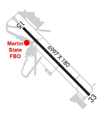 Airport Diagram might not be current. | |
| Facility Name: | MARTIN STATE |
| City Name: | BALTIMORE |
| County: | BALTIMORE |
| State abbrev: | MD |
| State Name: | MARYLAND |
| Ownership: | PUBLICLY OWNED |
| Use: | OPEN TO THE PUBLIC |
| Owner's Name: | MAA; MARYLAND AVIATION ADMINISTRATION. |
| Address: | BOX 1 701 WILSON PT RD |
| BALTIMORE, MD 21220 | |
| Owner's Phone: | 410-682-8800 |
| Manager's Name: | ALFRED POLLARD, A.A.E. |
| Address: | BOX 1, 701 WILSON POINT RD |
| BALTIMORE, MD 21220 | |
| Phone: | 410-682-8800 |
| FAA Region: | EASTERN |
| FAA Field Office: | DCA |
| Date | Sunrise | Sunset |
|---|---|---|
| 09/24/21 Friday | 6:55 | 19:00 |
| 09/25/21 Saturday | 6:56 | 18:58 |
| 09/26/21 Sunday | 6:57 | 18:57 |
| 09/27/21 Monday | 6:58 | 18:55 |
| 09/28/21 Tuesday | 6:59 | 18:53 |
| 09/29/21 Wednesday | 7:00 | 18:52 |
| 09/30/21 Thursday | 7:00 | 18:50 |
| 10/01/21 Friday | 7:01 | 18:49 |
| 10/02/21 Saturday | 7:02 | 18:47 |
| 10/03/21 Sunday | 7:03 | 18:45 |
| 10/04/21 Monday | 7:04 | 18:44 |
| 10/05/21 Tuesday | 7:05 | 18:42 |
| 10/06/21 Wednesday | 7:06 | 18:41 |
| 10/07/21 Thursday | 7:07 | 18:39 |
| Airport Attendance Schedule | 7 Days A Week 0600-2300 |
| Airport Status | OPERATIONAL (This Status can change at any time - please check NOTAMS) |
| Airport Lighting Schedule | DUSK-DAWN. WHEN ATCT CLSD ACTVT HIRL RY 15/33; REIL RYS 15 & 33 - CTAF. WHEN ATCT CLSD ACTVT TWY F LGTS - UNICOM. |
| Airport Storage Available | Tie Downs, Hanger |
| Extra Services Available | Air Ambulance, Avionics, Charter, Flight Instruction, Aircraft Rental |
| Wind Indicator | YES - (lighted) |
| Control Tower | YES |
| CTAF Frequency | 121.300 |
| Unicom Frequency | 122.950 |
| Rotating Beacon Color | CLEAR-GREEN (Light Land Airport) |
| Segmented Circle | NO |
| Landing Fee | NO |
| Airport Inspected | STATE - performed by STATE AERONAUTICAL PERSONNEL |
| Inspection Date | 10/06/2020 |
| Type of Fuel Available | Grade 100LL, JET A (freeze point -40C), JET A; -1024 HR SELF SERVE 100LL AVBL WITH CREDIT CARD. HELIS NOT AUTH TO ACES THE 100-LL SELF SVC STN UNDER OWN PWR. |
| Airframe Repair Service | MINOR |
| Power Plant Repair Service | MINOR |
| Latitude | N3919.5 |
| Longitude | W07624.8 (ESTIMATED) |
| Arpt Elevation | 21ft (SURVEYED) |
| Magnetic Variation | 11W |
| 9 miles E | of BALTIMORE |
| Traffic Pattern Altitude | TPA RECIPROCATING ENG ACFT 978 FT AGL; TURBOPROP & CIVIL JET ACFT 1478 FT AGL; MIL JET ACFT 1978 FT AGL. |
| Sectional Chart | WASHINGTON |
| Operations (Reported) | Yearly | Avg. Daily |
|---|---|---|
| General Aviation Transient | 37196 | 102 |
| General Aviation Local | 33489 | 92 |
| Air Taxi | 2219 | 6 |
| Commerical | 0 | 0 |
| Commuter | 0 | 0 |
| Military | 2200 | 6 |
| Aircraft based on Field | |
|---|---|
| General Aviation Singles | 145 |
| General Aviation Multi | 14 |
| Jet Aircraft | 24 |
| General Aviation Helicopters | 24 |
| Military Aircraft | 24 |
| Gliders | 1 |
| Ultralights | 0 |
| FSS on field | NO |
| FSS tie-in | LEESBURG |
| FSS Phone | 1-800-WX-BRIEF |
| Who issues Notams | MTN |
| Notam D service at airport | YES |
| ARTCC Name | WASHINGTON |
| Airport Certification | |
| Aircraft Rescue & Firefighting Index | ARFF SVCS AVBL 24 HRS DAILY. FOR ARFF SVCS WHEN ATCT CLSD CTC ARFF STATION; CTAF OR 410-918-6257 / 410-918-6911. |
| Airport of Entry | No |
| Custom Landing Rights | No |
| Joint Civil/Military | No |
| Military Landing rights | YES |
| NATIONAL PLAN OF INTEGRATED AIRPORT SYSTEMS (NPIAS) |
| GRANT AGREEMENTS UNDER FAAP/ADAP/AIP |
| ASSURANCES PURSUANT TO TITLE VI, CIVIL RIGHTS ACT OF 1964 |
| NOISE ABATEMENT PROCEDURES IN EFFECT. WHEN ATCT CLSD NO PRACTICE LNDGS OR APCHS. |
| BEARING STRENGTH RY 15/33: ST175. |
| CAUTION: BASH II IN EFFECT AUG-JAN. |
| FOR CD WHEN TWR CLSD CTC POTOMAC APCH AT 866-429-5822. |
| ARFF SVCS AVBL 24 HRS DAILY. FOR ARFF SVCS WHEN ATCT CLSD CTC ARFF STATION; CTAF OR 410-918-6257 / 410-918-6911. |
| NO ACFT ACCESS TO TWY S FM STRAWBERRY POINT RAMP. |
| SEAGULLS ON & INVOF ARPT. |
| ARPT CONDS UNMONITORED 2300-0600. |
| MOWING OPS CONDUCTED DURG DALGT. |
| PPR FOR PRACTICE TKOFS & LNDGS FOR ACFT WEIGHING MORE THAN 12500 LBS. |
| RECREATIONAL SAILBOAT MASTS TO +50 FT & MOTOR BOATS IN WATERWAY AT AER 33 813 FT FM THLD 0B. |
| FOR ADDL INFO CTC AMGR 410-682-8800. |
| RWY 17 ACFT RSTD TO TWY A. |
| RWY 15/3 3 8100 FT AVBL FOR TKOF RWY 15 AND LNDG RWY 33 FOR MIL ACFT ONLY. |
Airport Communications & Frequencies:
| |||||||||||||||||||||||||||||||||||||||
| Runway: 15 | Runway: 33 | ||
| Mag heading: | 146° | Mag heading: | 326° |
| Rwy Slope: | -.17% Down | Rwy Slope: | .17% Up |
| Approach: | LOC/DME | Approach: | ILS/DME |
| Pattern: | Left Traffic | Pattern: | Left Traffic |
| Markings: | NONPRECISION INSTRUMENT | Markings: | PRECISION INSTRUMENT |
| Marking Condition: | GOOD | Marking Condition: | GOOD |
| Arresting Dev: | Arresting Dev: | ||
| Lat & Long: | N3919.9 W07625.3 | Lat. & Long.: | N3919.1 W07624.3 |
| Elev: | 21.3 ft. MSL | Elev: | 9.2 ft. MSL |
| TCH: | 37 ft. AGL | TCH: | 44 ft. AGL |
| Visual Glide Path: | 4.01 degrees | Visual Glide Path: | 2.91 degrees |
| Displaced Threshold: | No | Displaced Threshold: | No |
| Touchdown Zone: | YES | Touchdown Zone: | YES |
| Touchdown Elev.: | 21.5 feet | Touchdown Elev.: | 14.3 feet |
| Visual Glide Slope: | PULSATING/STEADY BURNING VASI ON LEFT SIDE OF RUNWAY; UNUSBL BYD 5 DEGS EITHER SIDE OF CENTERLINE. | Visual Glide Slope: | PULSATING/STEADY BURNING VASI ON LEFT SIDE OF RUNWAY |
| RVR Equipment: | RVR Equipment: | ||
| RVV Equipment: | NO | RVV Equipment: | NO |
| Approach Lights: | Approach Lights: | ||
| REIL: | YES | REIL: | YES |
| Centerline Lights: | NO | Centerline Lights: | NO |
| Touchdown lights: | NO | Touchdown lights: | NO |
| Runway Category: | Runway with a Non-precision Approach having visibility minimums greater than 3/4 mile | Runway Category: | Precision Instrument Runway |
| Declared Distances: | Declared Distances: | ||
| Obstructions: | TREES | Obstructions: | TREES |
| Marked: | NOT Marked/Lighted | Marked: | NOT Marked/Lighted |
| Clearance slope: | 21:1 | Clearance slope: | 21:1 |
| Obstruction height: | 97 feet AGL | Obstruction height: | 25 feet AGL |
| Dist. from runway: | 2248 feet | Dist. from runway: | 729 feet |
| Centerline offset: | Centerline offset: | 464 feet left of centerline | |
| Comments: | Comments: |
Thanks for using FltPlan.com
all rights reserved © 1999-2021 by Flight Plan LLC