
| MONTROSE RGNL MONTROSE CO |
| |
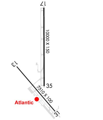
| Lat: N 3830.6 Long: W 10753.7 Elev: 5759 Var: -12 Longest Runway: 10000 | ||
| AWOS: 135.22 CTAF: 122.8 | ||
| ||||||||||||||||||||||||||||||||||||||||||||||||||||||||||||||||||||
| ||||||||||||||||||||||||||||||||||||||||||||||||||||||||||||||||||||
| ||||||||||||||||||||||||||||||||||||||||||||||||||||||||||||||||||||
| FBOs at nearby airports who want your business: | |||||||||||||||||
| |||||||||||||||||
| Rwy | Rwy | |||||||
| 7510x100 | 7510' | 7510x100 | 7510' | |||||
| 10000x150 | 10000' | 111.30 - 167° | 10000x150 | 10000' | ||||
| Runway ID | Single Wheel | Double Wheel | Double Tandem Wheel | Dual Double Wheel |
| 13/31 | 65,000 | 90,000 | 150,000 | N/A |
| 17/35 | 75,000 | 190,000 | 265,000 | N/A |
| These numbers are Advisory and are not limits. The Airport Manager should have more accurate Weight Limits | ||||
 Airport Diagram might not be current. | |
| Facility Name: | MONTROSE RGNL |
| City Name: | MONTROSE |
| County: | MONTROSE |
| State abbrev: | CO |
| State Name: | COLORADO |
| Ownership: | PUBLICLY OWNED |
| Use: | OPEN TO THE PUBLIC |
| Owner's Name: | MONTROSE COUNTY |
| Address: | 161 S. TOWNSEND |
| MONTROSE, CO 81401 | |
| Owner's Phone: | 970-249-7755 |
| Manager's Name: | LLOYD ARNOLD; AIRPORT ADMINISTRATION CONTACTS - VEE STOCKDALE AND LARRY BLACKWELL 970-249-3203, EXT 5811. |
| Address: | 2100 AIRPORT ROAD |
| MONTROSE, CO 81401 | |
| Phone: | 970-249-3433 |
| FAA Region: | NORTHWEST MOUNTAIN |
| FAA Field Office: | DEN |
| Date | Sunrise | Sunset |
|---|---|---|
| 09/24/21 Friday | 7:01 | 19:06 |
| 09/25/21 Saturday | 7:02 | 19:04 |
| 09/26/21 Sunday | 7:03 | 19:03 |
| 09/27/21 Monday | 7:04 | 19:01 |
| 09/28/21 Tuesday | 7:04 | 18:59 |
| 09/29/21 Wednesday | 7:05 | 18:58 |
| 09/30/21 Thursday | 7:06 | 18:56 |
| 10/01/21 Friday | 7:07 | 18:55 |
| 10/02/21 Saturday | 7:08 | 18:53 |
| 10/03/21 Sunday | 7:09 | 18:52 |
| 10/04/21 Monday | 7:10 | 18:50 |
| 10/05/21 Tuesday | 7:11 | 18:48 |
| 10/06/21 Wednesday | 7:12 | 18:47 |
| 10/07/21 Thursday | 7:13 | 18:45 |
| Airport Attendance Schedule | APR1-DEC15 7 Days A Week 0530-2100, DEC16-MAR31 7 Days A Week 0500-2100 |
| Airport Status | OPERATIONAL (This Status can change at any time - please check NOTAMS) |
| Airport Lighting Schedule | ACTVT HIRL RYS 13/31 & RY 17/35, MALSR RY 17, AND REIL RY 13, RY 31, & RY 35 - CTAF. |
| Airport Storage Available | Tie Downs, Hanger |
| Extra Services Available | Air Ambulance, Flight Instruction, Aircraft Rental |
| Wind Indicator | YES - (lighted) |
| Control Tower | NO |
| CTAF Frequency | 122.800 |
| Unicom Frequency | 122.800 |
| Rotating Beacon Color | CLEAR-GREEN (Light Land Airport) |
| Segmented Circle | YES |
| Landing Fee | NO |
| Airport Inspected | FEDERAL - performed by FAA AIRPORTS FIELD PERSONNEL |
| Inspection Date | 06/30/2021 |
| Type of Fuel Available | Grade 100LL, JET A |
| Airframe Repair Service | MAJOR |
| Power Plant Repair Service | MAJOR |
| Latitude | N3830.6 |
| Longitude | W10753.7 (ESTIMATED) |
| Arpt Elevation | 5758ft (SURVEYED) |
| Magnetic Variation | 12E |
| 1 miles NW | of MONTROSE |
| Traffic Pattern Altitude | |
| Sectional Chart | DENVER |
| Operations (Reported) | Yearly | Avg. Daily |
|---|---|---|
| General Aviation Transient | 13500 | 37 |
| General Aviation Local | 14000 | 38 |
| Air Taxi | 200 | 1 |
| Commerical | 6850 | 19 |
| Commuter | 0 | 0 |
| Military | 2000 | 5 |
| Aircraft based on Field | |
|---|---|
| General Aviation Singles | 59 |
| General Aviation Multi | 13 |
| Jet Aircraft | 2 |
| General Aviation Helicopters | 3 |
| Military Aircraft | 0 |
| Gliders | 3 |
| Ultralights | 1 |
| FSS on field | NO |
| FSS tie-in | DENVER |
| FSS Phone | 1-800-WX-BRIEF |
| Who issues Notams | MTJ |
| Notam D service at airport | YES |
| ARTCC Name | DENVER |
| Airport Certification | AIRPORT RECEIVING SCHEDULED AIR CARRIER SERVICE FROM CARRIERS CERTIFICATED BY THE CIVIL AERONAUTICS BOARD; UNSCHEDULED ACR OPNS WITH MORE THAN 30 PSGR SEATS REQUIRE 24 HR PPR CALL AMGR 970-249-3433. |
| Aircraft Rescue & Firefighting Index | AIRPORT HAS A CERTIFICATE UNDER CFR PART 139 |
| Airport of Entry | No |
| Custom Landing Rights | No |
| Joint Civil/Military | No |
| Military Landing rights | YES |
| NATIONAL PLAN OF INTEGRATED AIRPORT SYSTEMS (NPIAS) |
| GRANT AGREEMENTS UNDER FAAP/ADAP/AIP |
| ASSURANCES PURSUANT TO TITLE VI, CIVIL RIGHTS ACT OF 1964 |
| FOR CD IF UNA TO CTC ON FSS FREQ, CTC DENVER ARTCC AT 303-651-4257. |
| PREFERRED TKOF RYS 31 & 35 AND LAND RYS 13 & 17. |
| MIGRATORY BIRDS & WILDLIFE ON & INVOF ARPT. |
| 17/35 PREFERRED RUNWAY FOR AIRCRAFT WITH APPROACH SPEED GREATER THAN 121 KTS. 13/31 RECOMMENDED FOR AIRCRAFT WITH APPROACH SPEED LESS THAN 121 KNOTS. |
| AIR CARRIER ACFT REQUESTED TO ACCESS TERMINAL RAMP VIA TWY C, OUTBOUND TRAFFIC TWY D. |
| RAMP CONNECTOR ADJ TO T HANGAR ROW CLSD INDEFLY. TWY E, E6 CLSD EXCEPT ACFT WITH WINGSPAN LESS THAN 78 FT. |
| TWY B LTD TO SINGLE WHEEL ACFT MAXIMUM 80,000 LBS, DOUBLE WHEEL ACFT MAXIMUM 105,000 LBS, AND DOUBLE TANDEM WHEEL ACFT MAXIMUM 170,000 LBS. |
Airport Communications & Frequencies:
| |||||||||
| Runway: 13 | Runway: 31 | ||
| Mag heading: | 127° | Mag heading: | 307° |
| Rwy Slope: | .80% Up | Rwy Slope: | -.80% Down |
| Approach: | Approach: | ||
| Pattern: | Left Traffic | Pattern: | Left Traffic |
| Markings: | NONPRECISION INSTRUMENT | Markings: | NONPRECISION INSTRUMENT |
| Marking Condition: | GOOD | Marking Condition: | GOOD |
| Arresting Dev: | Arresting Dev: | ||
| Lat & Long: | N3830.6 W10754.3 | Lat. & Long.: | N3829.6 W10753.3 |
| Elev: | 5698.5 ft. MSL | Elev: | 5758.5 ft. MSL |
| TCH: | 43 ft. AGL | TCH: | 43 ft. AGL |
| Visual Glide Path: | 3.00 degrees | Visual Glide Path: | 3.00 degrees |
| Displaced Threshold: | No | Displaced Threshold: | No |
| Touchdown Zone: | YES | Touchdown Zone: | YES |
| Touchdown Elev.: | 5723.1 feet | Touchdown Elev.: | 5758.5 feet |
| Visual Glide Slope: | 4-BOX VASI ON LEFT SIDE OF RUNWAY | Visual Glide Slope: | 4-BOX VASI ON LEFT SIDE OF RUNWAY |
| RVR Equipment: | RVR Equipment: | ||
| RVV Equipment: | NO | RVV Equipment: | NO |
| Approach Lights: | Approach Lights: | ||
| REIL: | YES | REIL: | YES |
| Centerline Lights: | NO | Centerline Lights: | NO |
| Touchdown lights: | NO | Touchdown lights: | NO |
| Runway Category: | Runway with a Non-precision Approach having visibility minimums greater than 3/4 mile | Runway Category: | Runway with a Visual Approach |
| Declared Distances: | TORA:7510' TODA:7510' ASDA:7510' LDA:7510' | Declared Distances: | TORA:7510' TODA:7510' ASDA:7510' LDA:7510' |
| Obstructions: | TREE | Obstructions: | |
| Marked: | NOT Marked/Lighted | Marked: | |
| Clearance slope: | 45:1; THREE SEPARATE POLE OBSTRUCTIONS LGTD & MKD 1.5 MILES NW RY 13. | Clearance slope: | 20:1 |
| Obstruction height: | 41 feet AGL | Obstruction height: | |
| Dist. from runway: | 2050 feet | Dist. from runway: | |
| Centerline offset: | 575 right of centerline | Centerline offset: | |
| Comments: | Comments: |
| Runway: 17 | Runway: 35 | ||
| Mag heading: | 168° | Mag heading: | 348° |
| Rwy Slope: | .40% Up | Rwy Slope: | -.40% Down |
| Approach: | LOC/GS | Approach: | |
| Pattern: | Left Traffic | Pattern: | Left Traffic |
| Markings: | PRECISION INSTRUMENT | Markings: | PRECISION INSTRUMENT |
| Marking Condition: | GOOD | Marking Condition: | GOOD |
| Arresting Dev: | Arresting Dev: | ||
| Lat & Long: | N3831.8 W10753.6 | Lat. & Long.: | N3830.1 W10753.6 |
| Elev: | 5693.7 ft. MSL | Elev: | 5734.1 ft. MSL |
| TCH: | 55 ft. AGL | TCH: | 41 ft. AGL |
| Visual Glide Path: | 3.00 degrees | Visual Glide Path: | 3.00 degrees |
| Displaced Threshold: | No | Displaced Threshold: | No |
| Touchdown Zone: | YES | Touchdown Zone: | YES |
| Touchdown Elev.: | 5708.3 feet | Touchdown Elev.: | 5734.2 feet |
| Visual Glide Slope: | 4-Light PAPI on LEFT side of Runway | Visual Glide Slope: | 4-Light PAPI on LEFT side of Runway |
| RVR Equipment: | RVR Equipment: | ||
| RVV Equipment: | NO | RVV Equipment: | NO |
| Approach Lights: | MALSR - 1,400 foot medium intensity approach lighting system with runway alignment indicator lights | Approach Lights: | |
| REIL: | NO | REIL: | YES |
| Centerline Lights: | NO | Centerline Lights: | NO |
| Touchdown lights: | NO | Touchdown lights: | NO |
| Runway Category: | Precision Instrument Runway | Runway Category: | Runway with a Non-precision Approach having visibility minimums greater than 3/4 mile |
| Declared Distances: | TORA:10000' TODA:10000' ASDA:10000' LDA:10000' | Declared Distances: | TORA:10000' TODA:10000' ASDA:10000' LDA:10000' |
Thanks for using FltPlan.com
all rights reserved © 1999-2021 by Flight Plan LLC