
| MASSENA INTL-RICHARDS FIELD MASSENA NY |
| |
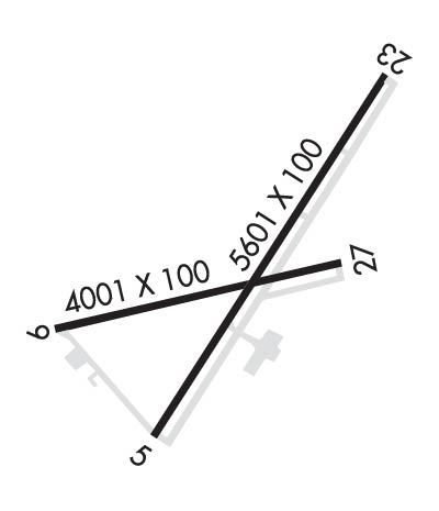
| Lat: N 4456.2 Long: W 07450.7 Elev: 222 Var: +14 Longest Runway: 5601 | ||
| AWOS: 128.07 CTAF: 123.0 | ||
| ||||||
| ||||||
|
| Rwy | Rwy | |||||||
| 5601x100 | 5601' | 108.70 - 045° | 5601x100 | 5601' | ||||
| 4000x100 | 4000' | 4000x100 | 4000' | |||||
| Runway ID | Single Wheel | Double Wheel | Double Tandem Wheel | Dual Double Wheel |
| 05/23 | 30,000 | 50,000 | 76,000 | N/A |
| 09/27 | 30,000 | 50,000 | 76,000 | N/A |
| These numbers are Advisory and are not limits. The Airport Manager should have more accurate Weight Limits | ||||
 Airport Diagram might not be current. | |
| Facility Name: | MASSENA INTL-RICHARDS FLD |
| City Name: | MASSENA |
| County: | ST LAWRENCE |
| State abbrev: | NY |
| State Name: | NEW YORK |
| Ownership: | PUBLICLY OWNED |
| Use: | OPEN TO THE PUBLIC |
| Owner's Name: | TOWN OF MASSENA |
| Address: | MAIN ST - TOWN HALL |
| MASSENA, NY 13662 | |
| Owner's Phone: | 315-769-3588 |
| Manager's Name: | DYLAN CASSELMAN |
| Address: | 90 AVIATION ROAD |
| MASSENA, NY 13662 | |
| Phone: | 315-769-7605 |
| FAA Region: | EASTERN |
| FAA Field Office: | NYC |
| Date | Sunrise | Sunset |
|---|---|---|
| 06/08/26 Monday | 5:13 | 20:44 |
| 06/09/26 Tuesday | 5:13 | 20:44 |
| 06/10/26 Wednesday | 5:13 | 20:45 |
| 06/11/26 Thursday | 5:13 | 20:46 |
| 06/12/26 Friday | 5:12 | 20:46 |
| 06/13/26 Saturday | 5:12 | 20:47 |
| 06/14/26 Sunday | 5:12 | 20:47 |
| 06/15/26 Monday | 5:12 | 20:48 |
| 06/16/26 Tuesday | 5:12 | 20:48 |
| 06/17/26 Wednesday | 5:12 | 20:48 |
| 06/18/26 Thursday | 5:12 | 20:49 |
| 06/19/26 Friday | 5:12 | 20:49 |
| 06/20/26 Saturday | 5:13 | 20:49 |
| 06/21/26 Sunday | 5:13 | 20:49 |
| Airport Attendance Schedule | MON-FRI 0400-1700, SAT-SUN 0700-0800 |
| Airport Status | OPERATIONAL (This Status can change at any time - please check NOTAMS) |
| Airport Lighting Schedule | ACTVT REIL RWY 05, 09 & 27; PAPI RWY 23, 27; HIRL RWY 05/23; MIRL RWY 09/27; TWY LGTS - CTAF. PAPI RWY 05 OPR CONSLY. |
| Airport Storage Available | Tie Downs, Hanger |
| Extra Services Available | Air Freight, Cargo Handling, Charter |
| Wind Indicator | YES - (lighted) |
| Control Tower | NO |
| CTAF Frequency | 123.000 |
| Unicom Frequency | 123.000 |
| Rotating Beacon Color | WG |
| Segmented Circle | NO |
| Landing Fee | YES |
| Airport Inspected | FEDERAL - performed by FAA AIRPORTS FIELD PERSONNEL |
| Inspection Date | 05/06/2025 |
| Type of Fuel Available | Grade 100LL, JET A (freeze point -40C) |
| Airframe Repair Service | MINOR |
| Power Plant Repair Service | NONE |
| Latitude | N4456.2 |
| Longitude | W07450.7 (ESTIMATED) |
| Arpt Elevation | 221ft (SURVEYED) |
| Magnetic Variation | 14W |
| 2 miles E | of MASSENA |
| Traffic Pattern Altitude | |
| Sectional Chart | MONTREAL |
| Operations (Reported) | Yearly | Avg. Daily |
|---|---|---|
| General Aviation Transient | 0 | 0 |
| General Aviation Local | 0 | 0 |
| Air Taxi | 0 | 0 |
| Commerical | 0 | 0 |
| Commuter | 0 | 0 |
| Military | 0 | 0 |
| Aircraft based on Field | |
|---|---|
| General Aviation Singles | 0 |
| General Aviation Multi | 0 |
| Jet Aircraft | 0 |
| General Aviation Helicopters | 0 |
| Military Aircraft | 0 |
| Gliders | 0 |
| Ultralights | 0 |
| FSS on field | NO |
| FSS tie-in | BURLINGTON |
| FSS Phone | 1-800-WX-BRIEF |
| Who issues Notams | MSS |
| Notam D service at airport | YES |
| ARTCC Name | BOSTON |
| Airport Certification | AIRPORT RECEIVING SCHEDULED AIR CARRIER SERVICE FROM CARRIERS CERTIFICATED BY THE CIVIL AERONAUTICS BOARD; PPR 24 HRS FOR ACFT OPS WITH MORE THAN 30 PAX SEATS CALL AMGR (315) 769-7605. |
| Aircraft Rescue & Firefighting Index | AIRPORT HAS A CERTIFICATE UNDER CFR PART 139 |
| Airport of Entry | YES |
| Custom Landing Rights | No |
| Joint Civil/Military | No |
| Military Landing rights | YES |
| NATIONAL PLAN OF INTEGRATED AIRPORT SYSTEMS (NPIAS) |
| GRANT AGREEMENTS UNDER FAAP/ADAP/AIP |
| ASSURANCES PURSUANT TO TITLE VI, CIVIL RIGHTS ACT OF 1964 |
| AGREEMENT UNDER DLAND OR DCLA HAS EXPIRED. |
| FREQUENT CONCENTRATION OF SEAGULLS AND CANADA GEESE ON AND INVOF ARPT PARTICULARLY DURG POOR WX PERIODS. |
| CTN NVD OPS CONDUCTED PERIODICALLY IN ARPT TFC PAT AREA. |
| MIL HEL TRNG ON & INVOF ARPT. |
| FOR CD IF UNA TO CTC ON FSS FREQ, CTC BOSTON ARTCC AT 603-879-6859 . |
| INDEX A COVERAGE AVBL DURG ATNDC HRS. FOR EMERGS OUTSIDE OF ATNDC HRS, CALL ST LAWRENCE CO EMERG SVCS AT 911. |
| 421 FT LGTD/MKD TWR 6000 FT S OF ARPT. |
| BIRDS & DEER ON & INVOF ARPT. |
| RY CONDS RPRTD DUR NML HRS OF OPN. |
| OVERNIGHT ACFT PARKING AVBL AT TERMINAL APRON. |
| AFTER ATTENDANCE HRS VEHICLE & PEDESTRIAN ACCESS TO FBO APRON & HANGAR ONLY AVBL WITH KEY CARD FOR AUTOMATIC GATE. |
| COMMUTER AIRCRAFT SECURE AREA CLOSED TO GENERAL AVIATION AIRCRAFT CLEARING CUSTOMS. PARKING AVAILABLE TO RIGHT OF TERMINAL BUILDING. |
| RWY 05/2 3 RWY 05 FIRST 50 FT NOT GRVD. |
| RWY 09/2 7 RWY 09 FIRST 50 FT NOT GRVD. RWY 27 FIRST 50 FT NOT GRVD. |
| RWY 05/2 3 PCR VALUE: 360/F/D/X/T |
| RWY 09/2 7 PCR VALUE: 343/F/D/X/T |
Airport Communications & Frequencies:
| |||||||||
| Runway: 05 | Runway: 23 | ||
| Mag heading: | 45° | Mag heading: | 225° |
| Rwy Slope: | .32% Up | Rwy Slope: | -.32% Down |
| Approach: | ILS | Approach: | |
| Pattern: | Left Traffic | Pattern: | Left Traffic |
| Markings: | PRECISION INSTRUMENT | Markings: | NONPRECISION INSTRUMENT |
| Marking Condition: | GOOD | Marking Condition: | GOOD |
| Arresting Dev: | Arresting Dev: | ||
| Lat & Long: | N4455.8 W07451.0 | Lat. & Long.: | N4456.6 W07450.3 |
| Elev: | 203.5 ft. MSL | Elev: | 221.5 ft. MSL |
| TCH: | 55 ft. AGL | TCH: | 43 ft. AGL |
| Visual Glide Path: | 3.00 degrees | Visual Glide Path: | 3.00 degrees |
| Displaced Threshold: | No | Displaced Threshold: | No |
| Touchdown Zone: | YES | Touchdown Zone: | YES |
| Touchdown Elev.: | 205.2 feet | Touchdown Elev.: | 221.5 feet |
| Visual Glide Slope: | 4-Light PAPI on LEFT side of Runway | Visual Glide Slope: | 4-Light PAPI on LEFT side of Runway |
| RVR Equipment: | RVR Equipment: | ||
| RVV Equipment: | NO | RVV Equipment: | NO |
| Approach Lights: | Approach Lights: | ||
| REIL: | YES | REIL: | NO |
| Centerline Lights: | NO | Centerline Lights: | NO |
| Touchdown lights: | NO | Touchdown lights: | NO |
| Runway Category: | Precision Instrument Runway | Runway Category: | Runway with a Non-precision Approach having visibility minimums greater than 3/4 mile |
| Declared Distances: | TORA:5601' TODA:5601' ASDA:5601' LDA:5601' | Declared Distances: | TORA:5601' TODA:5601' ASDA:5601' LDA:5601' |
| Obstructions: | POLE | Obstructions: | |
| Marked: | NOT Marked/Lighted | Marked: | |
| Clearance slope: | 32:1 | Clearance slope: | 50:1 |
| Obstruction height: | 52 feet AGL | Obstruction height: | |
| Dist. from runway: | 1649 feet | Dist. from runway: | |
| Centerline offset: | 430 right of centerline | Centerline offset: | |
| Comments: | Comments: |
| Runway: 09 | Runway: 27 | ||
| Mag heading: | 90° | Mag heading: | 270° |
| Rwy Slope: | .04% Up | Rwy Slope: | -.04% Down |
| Approach: | Approach: | ||
| Pattern: | Left Traffic | Pattern: | Left Traffic |
| Markings: | NONPRECISION INSTRUMENT | Markings: | NONPRECISION INSTRUMENT |
| Marking Condition: | GOOD | Marking Condition: | GOOD |
| Arresting Dev: | Arresting Dev: | ||
| Lat & Long: | N4456.1 W07451.3 | Lat. & Long.: | N4456.2 W07450.4 |
| Elev: | 203.0 ft. MSL | Elev: | 204.7 ft. MSL |
| TCH: | TCH: | 35 ft. AGL | |
| Visual Glide Path: | Visual Glide Path: | 3.00 degrees | |
| Displaced Threshold: | No | Displaced Threshold: | No |
| Touchdown Zone: | YES | Touchdown Zone: | YES |
| Touchdown Elev.: | 205.1 feet | Touchdown Elev.: | 205.1 feet |
| Visual Glide Slope: | Visual Glide Slope: | 4-Light PAPI on LEFT side of Runway | |
| RVR Equipment: | RVR Equipment: | ||
| RVV Equipment: | NO | RVV Equipment: | NO |
| Approach Lights: | Approach Lights: | ||
| REIL: | YES | REIL: | YES |
| Centerline Lights: | NO | Centerline Lights: | NO |
| Touchdown lights: | NO | Touchdown lights: | NO |
| Runway Category: | Runway with a Non-precision Approach having visibility minimums greater than 3/4 mile | Runway Category: | Runway with a Non-precision Approach having visibility minimums greater than 3/4 mile |
| Declared Distances: | TORA:4000' TODA:4000' ASDA:4000' LDA:4000' | Declared Distances: | TORA:4000' TODA:4000' ASDA:4000' LDA:4000' |
| Obstructions: | TREES | Obstructions: | |
| Marked: | NOT Marked/Lighted | Marked: | |
| Clearance slope: | 20:1 | Clearance slope: | 34:1 |
| Obstruction height: | 88 feet AGL | Obstruction height: | |
| Dist. from runway: | 1764 feet | Dist. from runway: | |
| Centerline offset: | 365 left of centerline | Centerline offset: | |
| Comments: | Comments: |
Thanks for using FltPlan.com
all rights reserved © 1999-2026 by Flight Plan LLC
