
| DANE COUNTY RGNL-TRUAX FIELD MADISON WI |
| |
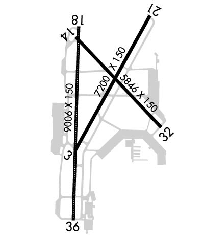
| Lat: N 4308.4 Long: W 08920.3 Elev: 887 Var: +03 Longest Runway: 9006 | ||
| Clr Del: 121.62 Dept. ATIS: 124.65 Arr. ATIS: 124.65 AWOS: 124.65 Ground: 121.9 Tower: 119.3 | ||
| ||||||||||||||||||||||||||||||||||||||||||||
| ||||||||||||||||||||||||||||||||||||||||||||
| ||||||||||||||||||||||||||||||||||||||||||||
| Rwy | Rwy | |||||||
| 7200x150 | 6769' | 7200x150 | 7200' | 111.55 - 214° | ||||
| 5846x150 | 5369' | 5846x150 | 5846' | |||||
| 9006x150 | 8606' | 110.10 - 184° | 9006x150 | 8005' | 110.10 - 004° | |||
| Runway ID | Single Wheel | Double Wheel | Double Tandem Wheel | Dual Double Wheel |
| 03/21 | 100,000 | 200,000 | 350,000 | N/A |
| 14/32 | 75,000 | 190,000 | 350,000 | N/A |
| 18/36 | 100,000 | 200,000 | 350,000 | N/A |
| These numbers are Advisory and are not limits. The Airport Manager should have more accurate Weight Limits | ||||
 Airport Diagram might not be current. | |
| Facility Name: | DANE COUNTY RGNL-TRUAX FLD |
| City Name: | MADISON |
| County: | DANE |
| State abbrev: | WI |
| State Name: | WISCONSIN |
| Ownership: | PUBLICLY OWNED |
| Use: | OPEN TO THE PUBLIC |
| Owner's Name: | DANE COUNTY |
| Address: | 4000 INTERNATIONAL LANE |
| MADISON, WI 53704 | |
| Owner's Phone: | 608-246-3380 |
| Manager's Name: | KIMBERLY S. JONES |
| Address: | 4000 INTERNATIONAL LANE |
| MADISON, WI 53704 | |
| Phone: | 608-246-3380 |
| FAA Region: | GREAT LAKES |
| FAA Field Office: | CHI |
| Date | Sunrise | Sunset |
|---|---|---|
| 09/24/21 Friday | 6:47 | 18:51 |
| 09/25/21 Saturday | 6:48 | 18:50 |
| 09/26/21 Sunday | 6:49 | 18:48 |
| 09/27/21 Monday | 6:50 | 18:46 |
| 09/28/21 Tuesday | 6:51 | 18:44 |
| 09/29/21 Wednesday | 6:52 | 18:42 |
| 09/30/21 Thursday | 6:53 | 18:41 |
| 10/01/21 Friday | 6:54 | 18:39 |
| 10/02/21 Saturday | 6:56 | 18:37 |
| 10/03/21 Sunday | 6:57 | 18:35 |
| 10/04/21 Monday | 6:58 | 18:34 |
| 10/05/21 Tuesday | 6:59 | 18:32 |
| 10/06/21 Wednesday | 7:00 | 18:30 |
| 10/07/21 Thursday | 7:01 | 18:28 |
| Airport Attendance Schedule | CONTINUOUS |
| Airport Status | OPERATIONAL (This Status can change at any time - please check NOTAMS) |
| Airport Lighting Schedule | WHEN ATCT CLSD HIRL RWY 18/36 PRESET ON LOW INTST, TO INCR INTST & ACTVT MALSR RWY 18 & 21; REIL RWY 03 & 32; HIRL RWY 03/21, RWY 14/32, RWY 18/36 - CTAF. PAPI RWY 03, 21, 14, 32, 18, 36 OPR CONSLY. |
| Airport Storage Available | Hanger |
| Extra Services Available | Air Freight, Air Ambulance, Avionics, Cargo Handling, Charter, Flight Instruction, Aircraft Rental, Aircraft Sales |
| Wind Indicator | YES - (lighted) |
| Control Tower | YES |
| CTAF Frequency | 119.300 |
| Unicom Frequency | 122.950 |
| Rotating Beacon Color | CLEAR-GREEN (Light Land Airport) |
| Segmented Circle | NO |
| Landing Fee | NO |
| Airport Inspected | FEDERAL - performed by FAA AIRPORTS FIELD PERSONNEL |
| Inspection Date | 10/11/2019 |
| Type of Fuel Available | Grade 100LL, JET A (freeze point -40C); -10AV FUEL REFUELING AVBL ON EAST OR SOUTH APRON ONLY. |
| Airframe Repair Service | MAJOR |
| Power Plant Repair Service | MAJOR |
| Latitude | N4308.4 |
| Longitude | W08920.3 (ESTIMATED) |
| Arpt Elevation | 886ft (SURVEYED) |
| Magnetic Variation | 03W |
| 5 miles NE | of MADISON |
| Traffic Pattern Altitude | MILITARY: OVHD TFC PAT ALT RSTRD TO 3500 FT MSL; RWY 18/36 L TURN. |
| Sectional Chart | CHICAGO |
| Operations (Reported) | Yearly | Avg. Daily |
|---|---|---|
| General Aviation Transient | 18659 | 51 |
| General Aviation Local | 9189 | 25 |
| Air Taxi | 4681 | 13 |
| Commerical | 10419 | 29 |
| Commuter | 0 | 0 |
| Military | 3320 | 9 |
| Aircraft based on Field | |
|---|---|
| General Aviation Singles | 75 |
| General Aviation Multi | 18 |
| Jet Aircraft | 27 |
| General Aviation Helicopters | 2 |
| Military Aircraft | 36 |
| Gliders | 0 |
| Ultralights | 0 |
| FSS on field | NO |
| FSS tie-in | GREEN BAY |
| FSS Phone | 1-800-WX-BRIEF |
| Who issues Notams | MSN |
| Notam D service at airport | YES |
| ARTCC Name | CHICAGO |
| Airport Certification | AIRPORT RECEIVING SCHEDULED AIR CARRIER SERVICE FROM CARRIERS CERTIFICATED BY THE CIVIL AERONAUTICS BOARD |
| Aircraft Rescue & Firefighting Index | AIRPORT HAS A CERTIFICATE UNDER CFR PART 139 |
| Airport of Entry | No |
| Custom Landing Rights | No |
| Joint Civil/Military | No |
| Military Landing rights | YES |
| NATIONAL PLAN OF INTEGRATED AIRPORT SYSTEMS (NPIAS) |
| GRANT AGREEMENTS UNDER FAAP/ADAP/AIP |
| SURPLUS PROPERTY AGREEMENT UNDER PUBLIC LAW 289 |
| ASSURANCES PURSUANT TO TITLE VI, CIVIL RIGHTS ACT OF 1964 |
| TWY F & G RSTRD TO MIL ACFT ONLY. |
| WEST RAMP RSTD TO AIR CARRIER ACFT ONLY. |
| MILITARY: ANG: PPR ALL ACT, CONTACT EMAIL: 115FW.PPR.ORG@US.AF.MIL. OPR HR 1200-2230Z++MON-THURS, DSN 724-8642/8436, C608 245-4642/4436. DSN 724-8580 H24, C608 245-4580 H24. |
| AVOID OVERFLIGHT OF YAHARA RIVER INVOF ARPT BLO 2000 FT AGL. |
| RW 14 & 18 APCH ENDS CLOSELY ALIGNED; VERIFY CORRECT RWY AND COMPASS HDG PRIOR TO DEP. |
| EAST RAMP & TWY B5 & E CLSD TO ACFT WITH WINGSPAN MORE THAN 118 FT. TWY B1, J & B NORTH OF TWY M CLSD TO ACFT WITH WINGSPAN MORE THAN 150 FT. |
| NOISE ABATEMENT PROC IN EFCT: DEP ACFT UTILIZE RWY 03 & 36; ARR ACFT UTILIZE RWY 18 & 21. |
| ARNG: PPR, ARNG COPTER RQR SVC, CTC ARMY OPS, LTD TRAN SVC, OPR 1300-2200Z++ MON, TUE; 1300-0400Z++ WED-FRI, CLSD SAT, SUN DSN 745-8310, C608-301-8310. |
| PPR FOR HIGH RISK FLT TEST 608-246-3397. |
| ENGINE RUNUP RSTD TO NORTH HOLD BAY ONLY. |
| BARRICADES ALONG WEST EDGE OF SOUTH RAMP ADJ MIL RAMP. |
| WEST RAMP UNCONTROLLED; PUSHBACK IS AT PILOT'S DISCRETION. |
| SERVICE-FUEL: A++ (MIL) |
| PPR RQRD FOR ALL MIL ACFT: 608-724-8506. |
| RWY 18,21, 36 BAK-14 ARRESTING CABLE FOR MIL USE ONLY AND RETRACTED WHEN NOT IN USE. |
| FOR CD IF UNA TO CTC ON FSS FREQ, CTC CHICAGO ARTCC AT 630-906-8921. |
| ACR & TURBO JET TRNG FLGTS PROHIBITED. |
| BIRDS ON & INVOF ARPT. |
Airport Communications & Frequencies:
| |||||||||||||||||||||||||||||||||||||||||||||||||
| Runway: 03 | Runway: 21 | ||
| Mag heading: | 32° | Mag heading: | 212° |
| Rwy Slope: | .36% Up | Rwy Slope: | -.36% Down |
| Approach: | Approach: | ILS/DME | |
| Pattern: | Left Traffic | Pattern: | Left Traffic |
| Markings: | PRECISION INSTRUMENT | Markings: | PRECISION INSTRUMENT |
| Marking Condition: | GOOD | Marking Condition: | GOOD |
| Arresting Dev: | Arresting Dev: | BAK-14; BAK-14 BAK-12(B) (1620'). | |
| Lat & Long: | N4308.0 W08920.5 | Lat. & Long.: | N4309.0 W08919.7 |
| Elev: | 860.8 ft. MSL | Elev: | 886.6 ft. MSL |
| TCH: | 49 ft. AGL | TCH: | 53 ft. AGL |
| Visual Glide Path: | 3.00 degrees | Visual Glide Path: | 3.00 degrees |
| Displaced Threshold: | 431 feet | Displaced Threshold: | No |
| Touchdown Zone: | YES | Touchdown Zone: | YES |
| Touchdown Elev.: | 859.7 feet | Touchdown Elev.: | 886.6 feet |
| Visual Glide Slope: | 4-Light PAPI on LEFT side of Runway | Visual Glide Slope: | 4-Light PAPI on LEFT side of Runway |
| RVR Equipment: | RVR Equipment: | ||
| RVV Equipment: | NO | RVV Equipment: | NO |
| Approach Lights: | Approach Lights: | MALSR - 1,400 foot medium intensity approach lighting system with runway alignment indicator lights | |
| REIL: | YES | REIL: | NO |
| Centerline Lights: | NO | Centerline Lights: | NO |
| Touchdown lights: | NO | Touchdown lights: | NO |
| Runway Category: | D | Runway Category: | Precision Instrument Runway |
| Declared Distances: | TORA:7200' TODA:7200' ASDA:7200' LDA:6770' | Declared Distances: | TORA:6770' TODA:6770' ASDA:7015' LDA:7015' |
| Obstructions: | TREES | Obstructions: | ROAD |
| Marked: | NOT Marked/Lighted | Marked: | NOT Marked/Lighted |
| Clearance slope: | 35:1; APCH RATIO 41:1 FM DSPLCD THR. | Clearance slope: | 50:1 |
| Obstruction height: | 72 feet AGL | Obstruction height: | 19 feet AGL |
| Dist. from runway: | 2760 feet | Dist. from runway: | 2050 feet |
| Centerline offset: | 460 left of centerline | Centerline offset: | |
| Comments: | Comments: |
| Runway: 14 | Runway: 32 | ||
| Mag heading: | 139° | Mag heading: | 319° |
| Rwy Slope: | .04% Up | Rwy Slope: | -.04% Down |
| Approach: | Approach: | ||
| Pattern: | Left Traffic | Pattern: | Left Traffic |
| Markings: | NONPRECISION INSTRUMENT | Markings: | NONPRECISION INSTRUMENT |
| Marking Condition: | GOOD | Marking Condition: | GOOD |
| Arresting Dev: | Arresting Dev: | ||
| Lat & Long: | N4308.9 W08920.5 | Lat. & Long.: | N4308.2 W08919.6 |
| Elev: | 858.9 ft. MSL | Elev: | 861.5 ft. MSL |
| TCH: | 45 ft. AGL | TCH: | 56 ft. AGL |
| Visual Glide Path: | 3.00 degrees | Visual Glide Path: | 3.00 degrees |
| Displaced Threshold: | 477 feet | Displaced Threshold: | No |
| Touchdown Zone: | YES | Touchdown Zone: | YES |
| Touchdown Elev.: | 860.9 feet | Touchdown Elev.: | 861.5 feet |
| Visual Glide Slope: | 4-Light PAPI on LEFT side of Runway | Visual Glide Slope: | 4-Light PAPI on LEFT side of Runway |
| RVR Equipment: | RVR Equipment: | ||
| RVV Equipment: | NO | RVV Equipment: | NO |
| Approach Lights: | Approach Lights: | ||
| REIL: | YES | REIL: | YES |
| Centerline Lights: | NO | Centerline Lights: | NO |
| Touchdown lights: | NO | Touchdown lights: | NO |
| Runway Category: | D | Runway Category: | Runway with a Non-precision Approach having visibility minimums greater than 3/4 mile |
| Declared Distances: | TORA:5846' TODA:5846' ASDA:5846' LDA:5369' | Declared Distances: | TORA:5846' TODA:5846' ASDA:5846' LDA:5846' |
| Obstructions: | Obstructions: | TREE | |
| Marked: | Marked: | NOT Marked/Lighted | |
| Clearance slope: | 34:1 | Clearance slope: | 34:1 |
| Obstruction height: | Obstruction height: | 112 feet AGL | |
| Dist. from runway: | Dist. from runway: | 4047 feet | |
| Centerline offset: | Centerline offset: | 440 feet right of centerline | |
| Comments: | Comments: |
| Runway: 18 | Runway: 36 | ||
| Mag heading: | 185° | Mag heading: | 5° |
| Rwy Slope: | .02% Up | Rwy Slope: | -.02% Down |
| Approach: | ILS/DME | Approach: | ILS/DME |
| Pattern: | Left Traffic | Pattern: | Left Traffic |
| Markings: | PRECISION INSTRUMENT | Markings: | PRECISION INSTRUMENT |
| Marking Condition: | GOOD | Marking Condition: | GOOD |
| Arresting Dev: | BAK-14; BAK-14 BAK-12(B) (1900'). | Arresting Dev: | BAK-14; BAK-14 BAK-12(B) (1750'). |
| Lat & Long: | N4308.9 W08920.5 | Lat. & Long.: | N4307.5 W08920.5 |
| Elev: | 860.3 ft. MSL | Elev: | 862.0 ft. MSL |
| TCH: | 57 ft. AGL | TCH: | 59 ft. AGL |
| Visual Glide Path: | 3.00 degrees | Visual Glide Path: | 3.00 degrees |
| Displaced Threshold: | 400 feet | Displaced Threshold: | 1001 feet |
| Touchdown Zone: | YES | Touchdown Zone: | YES |
| Touchdown Elev.: | 863.5 feet | Touchdown Elev.: | 862.0 feet |
| Visual Glide Slope: | 4-Light PAPI on LEFT side of Runway; UNUSBL BYD 9 DEGS RIGHT OF CNTRLN. | Visual Glide Slope: | 4-Light PAPI on LEFT side of Runway |
| RVR Equipment: | TOUCHDOWN-MIDFIELD-ROLLOUT | RVR Equipment: | TOUCHDOWN-MIDFIELD-ROLLOUT |
| RVV Equipment: | NO | RVV Equipment: | NO |
| Approach Lights: | MALSR - 1,400 foot medium intensity approach lighting system with runway alignment indicator lights | Approach Lights: | ALSF2 - standard 2,400 foot high intensity approach lighting system with sequenced flashers, Category II or III; RWY 36 ALSF2 OPRS AS SSALR WHEN TWR CLSD. |
| REIL: | NO | REIL: | NO |
| Centerline Lights: | YES | Centerline Lights: | YES |
| Touchdown lights: | NO | Touchdown lights: | NO |
| Runway Category: | Precision Instrument Runway | Runway Category: | Precision Instrument Runway |
| Declared Distances: | TORA:9006' TODA:9006' ASDA:9006' LDA:8606' | Declared Distances: | TORA:9006' TODA:9006' ASDA:9006' LDA:8006' |
| Obstructions: | HILL | Obstructions: | |
| Marked: | NOT Marked/Lighted | Marked: | |
| Clearance slope: | 28:1; APCH RATIO 40:1 FM DSPLCD THR. | Clearance slope: | 50:1 |
| Obstruction height: | 50 feet AGL | Obstruction height: | |
| Dist. from runway: | 1634 feet | Dist. from runway: | |
| Centerline offset: | 689 left of centerline | Centerline offset: | |
| Comments: | Comments: |
Thanks for using FltPlan.com
all rights reserved © 1999-2021 by Flight Plan LLC
