
| NORTHWEST ALABAMA RGNL MUSCLE SHOALS AL |
| |
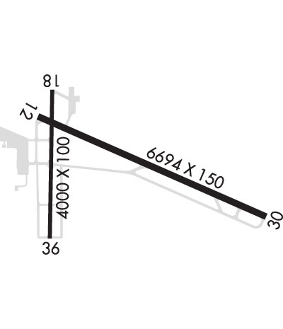
| Lat: N 3444.7 Long: W 08736.6 Elev: 551 Var: +03 Longest Runway: 6694 | ||
| Clr Del: GCO 121.72 AWOS: 119.42 CTAF: 123.05 | ||
| ||||||||||||||||||||||||||||||||||||||||||||
| ||||||||||||||||||||||||||||||||||||||||||||
| ||||||||||||||||||||||||||||||||||||||||||||
| Rwy | Rwy | |||||||
| 6694x150 | 6694' | 6694x150 | 6694' | 109.70 - 297° | ||||
| 4000x100 | 4000' | 4000x100 | 4000' | |||||
| Runway ID | Single Wheel | Double Wheel | Double Tandem Wheel | Dual Double Wheel |
| 12/30 | 59,000 | 98,000 | 160,000 | N/A |
| 18/36 | 30,000 | 50,000 | N/A | N/A |
| These numbers are Advisory and are not limits. The Airport Manager should have more accurate Weight Limits | ||||
 Airport Diagram might not be current. | |
| Facility Name: | NORTHWEST ALABAMA RGNL |
| City Name: | MUSCLE SHOALS |
| County: | COLBERT |
| State abbrev: | AL |
| State Name: | ALABAMA |
| Ownership: | PUBLICLY OWNED |
| Use: | OPEN TO THE PUBLIC |
| Owner's Name: | COLBERT & LAUDERDALE COUNTIES |
| Address: | 1729 T. ED CAMPBELL DR SUITE A |
| MUSCLE SHOALS, AL 35661-2016 | |
| Owner's Phone: | 256-381-2869 |
| Manager's Name: | BARRY GRIFFITH |
| Address: | 1729 T. ED CAMPBELL DR SUITE A |
| MUSCLE SHOALS, AL 35661-2016 | |
| Phone: | 256-383-2270; EXT. 101. |
| FAA Region: | SOUTHERN |
| FAA Field Office: | JAN |
| Date | Sunrise | Sunset |
|---|---|---|
| 06/07/26 Sunday | 5:37 | 20:02 |
| 06/08/26 Monday | 5:37 | 20:02 |
| 06/09/26 Tuesday | 5:37 | 20:03 |
| 06/10/26 Wednesday | 5:37 | 20:03 |
| 06/11/26 Thursday | 5:37 | 20:04 |
| 06/12/26 Friday | 5:37 | 20:04 |
| 06/13/26 Saturday | 5:37 | 20:04 |
| 06/14/26 Sunday | 5:37 | 20:05 |
| 06/15/26 Monday | 5:37 | 20:05 |
| 06/16/26 Tuesday | 5:37 | 20:06 |
| 06/17/26 Wednesday | 5:37 | 20:06 |
| 06/18/26 Thursday | 5:37 | 20:06 |
| 06/19/26 Friday | 5:37 | 20:06 |
| 06/20/26 Saturday | 5:37 | 20:07 |
| Airport Attendance Schedule | 7 Days A Week 0600-1800; EXC THANKSGIVING, CHRISTMAS, AND NEW YEARS DAY |
| Airport Status | OPERATIONAL (This Status can change at any time - please check NOTAMS) |
| Airport Lighting Schedule | ACTVT MALSR RWY 30; REIL RWY 12; PAPI RWY 12; PAPI RWY 18 & 36; HIRL RWY 12/30; MIRL RWY 18/36 - CTAF. |
| Airport Storage Available | Tie Downs, Hanger |
| Extra Services Available | Air Freight, Flight Instruction, Aircraft Rental |
| Wind Indicator | YES - (lighted) |
| Control Tower | NO |
| CTAF Frequency | 123.050 |
| Unicom Frequency | 123.050 |
| Rotating Beacon Color | WG |
| Segmented Circle | YES |
| Landing Fee | NO |
| Airport Inspected | FEDERAL - performed by FAA AIRPORTS FIELD PERSONNEL |
| Inspection Date | 07/09/2025 |
| Type of Fuel Available | Grade 100LL, JET A (freeze point -40C); -10FUEL AVBL NIGHTS CALL 256-383-2270. AVGAS 100LL SELF SERVE AVBL 24 HRS. |
| Airframe Repair Service | NONE |
| Power Plant Repair Service | NONE |
| Latitude | N3444.7 |
| Longitude | W08736.6 (ESTIMATED) |
| Arpt Elevation | 550ft (SURVEYED) |
| Magnetic Variation | 03W |
| 1 miles E | of MUSCLE SHOALS |
| Traffic Pattern Altitude | |
| Sectional Chart | ATLANTA |
| Operations (Reported) | Yearly | Avg. Daily |
|---|---|---|
| General Aviation Transient | 0 | 0 |
| General Aviation Local | 0 | 0 |
| Air Taxi | 0 | 0 |
| Commerical | 0 | 0 |
| Commuter | 0 | 0 |
| Military | 0 | 0 |
| Aircraft based on Field | |
|---|---|
| General Aviation Singles | 0 |
| General Aviation Multi | 0 |
| Jet Aircraft | 0 |
| General Aviation Helicopters | 0 |
| Military Aircraft | 0 |
| Gliders | 0 |
| Ultralights | 0 |
| FSS on field | NO |
| FSS tie-in | ANNISTON |
| FSS Phone | 1-800-WX-BRIEF |
| Who issues Notams | MSL |
| Notam D service at airport | YES |
| ARTCC Name | MEMPHIS |
| Airport Certification | AIRPORT RECEIVING SCHEDULED AIR CARRIER SERVICE FROM CARRIERS CERTIFICATED BY THE CIVIL AERONAUTICS BOARD; PPR FOR UNSKED ACR & CHTR OPNS WITH MORE THAN 30 PSGR SEATS; CALL AMGR (256) 381-2869, EXT 101 OR FAX (256) 381-2915. |
| Aircraft Rescue & Firefighting Index | AIRPORT HAS A CERTIFICATE UNDER CFR PART 139 |
| Airport of Entry | No |
| Custom Landing Rights | No |
| Joint Civil/Military | No |
| Military Landing rights | YES |
| NATIONAL PLAN OF INTEGRATED AIRPORT SYSTEMS (NPIAS) |
| GRANT AGREEMENTS UNDER FAAP/ADAP/AIP |
| CONVEYANCE UNDER SCETION 16, FEDERAL AIRPORT ACT OF 1946 OR SECTION 23, AIRPORT AND AIRWAY DEVELOPMENT ACT OF 1970 |
| ASSURANCES PURSUANT TO TITLE VI, CIVIL RIGHTS ACT OF 1964 |
| AGREEMENT UNDER DLAND OR DCLA HAS EXPIRED. |
| FOR CD IF UNA VIA GCO CTC MEMPHIS ARTCC AT 901-368-8453/8449. |
| NO GA PARKING ON ACR RAMP. |
| LNDG FEE & PAX FAC CHRG FOR UNSKED ACR & CHTR OPNS. |
| TWY A IS THE PREF TWY FOR ACR & CHTR OPNS USING THE ACR RAMP. |
| LNDG FEE FOR ACR OVER 12,500 LBS. |
| GCO AVBL ON FREQ 121.725 FOR MEMPHIS ARTCC (ZME). |
| RWY 18/3 6 RWY 18/36 NOT AVBL FOR PART 121/PART 380 OPS WITH SKED PAX CARRYING OPS MORE THAN 9 PAX SEATS AND NON-SKED PAX CARRYING OPS MORE THAN 30 PAX SEATS. |
| RWY 30 CALM WIND RWY. |
| RWY 12/3 0 PCR VALUE: 430/F/B/X/T |
| RWY 18/3 6 PCR VALUE: 470/F/C/X/T |
Airport Communications & Frequencies:
| |||||||||
| Runway: 12 | Runway: 30 | ||
| Mag heading: | 117° | Mag heading: | 297° |
| Rwy Slope: | .12% Up | Rwy Slope: | -.12% Down |
| Approach: | Approach: | ILS | |
| Pattern: | Left Traffic | Pattern: | Left Traffic |
| Markings: | PRECISION INSTRUMENT | Markings: | PRECISION INSTRUMENT |
| Marking Condition: | GOOD | Marking Condition: | GOOD |
| Arresting Dev: | Arresting Dev: | ||
| Lat & Long: | N3444.9 W08737.0 | Lat. & Long.: | N3444.5 W08735.8 |
| Elev: | 542.0 ft. MSL | Elev: | 550.2 ft. MSL |
| TCH: | 56 ft. AGL | TCH: | |
| Visual Glide Path: | 3.00 degrees | Visual Glide Path: | |
| Displaced Threshold: | No | Displaced Threshold: | No |
| Touchdown Zone: | YES | Touchdown Zone: | YES |
| Touchdown Elev.: | 544.2 feet | Touchdown Elev.: | 550.5 feet |
| Visual Glide Slope: | 4-Light PAPI on RIGHT side of Runway | Visual Glide Slope: | |
| RVR Equipment: | RVR Equipment: | ||
| RVV Equipment: | NO | RVV Equipment: | NO |
| Approach Lights: | Approach Lights: | MALSR - 1,400 foot medium intensity approach lighting system with runway alignment indicator lights | |
| REIL: | YES | REIL: | NO |
| Centerline Lights: | NO | Centerline Lights: | NO |
| Touchdown lights: | NO | Touchdown lights: | NO |
| Runway Category: | Runway with a Non-precision Approach having visibility minimums greater than 3/4 mile | Runway Category: | Precision Instrument Runway |
| Declared Distances: | Declared Distances: | ||
| Obstructions: | TREES | Obstructions: | TREES |
| Marked: | NOT Marked/Lighted | Marked: | NOT Marked/Lighted |
| Clearance slope: | 28:1 | Clearance slope: | 26:1 |
| Obstruction height: | 52 feet AGL | Obstruction height: | 68 feet AGL |
| Dist. from runway: | 1689 feet | Dist. from runway: | 2004 feet |
| Centerline offset: | 269 right of centerline | Centerline offset: | 530 feet left of centerline |
| Comments: | Comments: |
| Runway: 18 | Runway: 36 | ||
| Mag heading: | 184° | Mag heading: | 4° |
| Rwy Slope: | .04% Up | Rwy Slope: | -.04% Down |
| Approach: | Approach: | ||
| Pattern: | Left Traffic | Pattern: | Left Traffic |
| Markings: | NONPRECISION INSTRUMENT | Markings: | NONPRECISION INSTRUMENT |
| Marking Condition: | GOOD | Marking Condition: | GOOD |
| Arresting Dev: | Arresting Dev: | ||
| Lat & Long: | N3445.1 W08736.9 | Lat. & Long.: | N3444.4 W08737.0 |
| Elev: | 539.3 ft. MSL | Elev: | 540.9 ft. MSL |
| TCH: | 35 ft. AGL | TCH: | 40 ft. AGL |
| Visual Glide Path: | 3.00 degrees | Visual Glide Path: | 3.00 degrees |
| Displaced Threshold: | No | Displaced Threshold: | No |
| Touchdown Zone: | YES | Touchdown Zone: | YES |
| Touchdown Elev.: | 547.3 feet | Touchdown Elev.: | 547.3 feet |
| Visual Glide Slope: | 4-Light PAPI on LEFT side of Runway | Visual Glide Slope: | 4-Light PAPI on LEFT side of Runway |
| RVR Equipment: | RVR Equipment: | ||
| RVV Equipment: | NO | RVV Equipment: | NO |
| Approach Lights: | Approach Lights: | ||
| REIL: | NO | REIL: | NO |
| Centerline Lights: | NO | Centerline Lights: | NO |
| Touchdown lights: | NO | Touchdown lights: | NO |
| Runway Category: | Runway with a Non-precision Approach | Runway Category: | Runway with a Non-precision Approach |
| Declared Distances: | Declared Distances: | ||
| Obstructions: | TREE | Obstructions: | |
| Marked: | NOT Marked/Lighted | Marked: | |
| Clearance slope: | 11:1 | Clearance slope: | 34:1 |
| Obstruction height: | 61 feet AGL | Obstruction height: | |
| Dist. from runway: | 906 feet | Dist. from runway: | |
| Centerline offset: | 283 left of centerline | Centerline offset: | |
| Comments: | Comments: |
Thanks for using FltPlan.com
all rights reserved © 1999-2026 by Flight Plan LLC
