
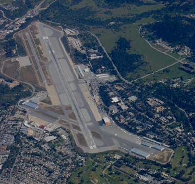
| MONTEREY PENINSULA MONTEREY CA |
| |
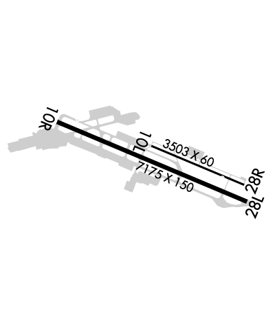
| Lat: N 3635.2 Long: W 12150.6 Elev: 257 Var: -15 Longest Runway: 7175 | ||
| Clr Del: 135.45 Dept. ATIS: 119.25 Arr. ATIS: 119.25 Ground: 120.87 Tower: 118.4 | ||
| ||||||||||||||||||||||||||||||||||||||||||||
| ||||||||||||||||||||||||||||||||||||||||||||
| ||||||||||||||||||||||||||||||||||||||||||||
| ||||||||||||||||||||||||||||||||||||||||||||
| Rwy | Rwy | |||||||
| 3503x60 | 3503' | 3503x60 | 3503' | |||||
| 7175x150 | 7000' | 110.70 - 097° | 7175x150 | 7000' | 110.70 - 277° | |||
| Runway ID | Single Wheel | Double Wheel | Double Tandem Wheel | Dual Double Wheel |
| 10L/28R | 12,500 | N/A | N/A | N/A |
| 10R/28L | 100,000 | 160,000 | 300,000 | N/A |
| These numbers are Advisory and are not limits. The Airport Manager should have more accurate Weight Limits | ||||
 Airport Diagram might not be current. | |
| Facility Name: | MONTEREY RGNL |
| City Name: | MONTEREY |
| County: | MONTEREY |
| State abbrev: | CA |
| State Name: | CALIFORNIA |
| Ownership: | PUBLICLY OWNED |
| Use: | OPEN TO THE PUBLIC |
| Owner's Name: | MONTEREY PENIN ARPT DIST |
| Address: | 200 FRED KANE DR., SUITE 200 |
| MONTEREY, CA 93940 | |
| Owner's Phone: | 831-648-7000 |
| Manager's Name: | MICHAEL LA PIER; KEN GRIGGS, OPNS MGR X221; KGRIGGS@MONTEREYAIRPORT.COM |
| Address: | 200 FRED KANE DR., SUITE 200 |
| MONTEREY, CA 93940 | |
| Phone: | 831-648-7000; OR (831) 333-2321 |
| FAA Region: | WESTERN-PACIFIC |
| FAA Field Office: | SFO |
| Date | Sunrise | Sunset |
|---|---|---|
| 09/24/21 Friday | 6:57 | 19:01 |
| 09/25/21 Saturday | 6:58 | 19:00 |
| 09/26/21 Sunday | 6:58 | 18:58 |
| 09/27/21 Monday | 6:59 | 18:57 |
| 09/28/21 Tuesday | 7:00 | 18:55 |
| 09/29/21 Wednesday | 7:01 | 18:54 |
| 09/30/21 Thursday | 7:02 | 18:52 |
| 10/01/21 Friday | 7:02 | 18:51 |
| 10/02/21 Saturday | 7:03 | 18:50 |
| 10/03/21 Sunday | 7:04 | 18:48 |
| 10/04/21 Monday | 7:05 | 18:47 |
| 10/05/21 Tuesday | 7:06 | 18:45 |
| 10/06/21 Wednesday | 7:07 | 18:44 |
| 10/07/21 Thursday | 7:08 | 18:42 |
| Airport Attendance Schedule | CONTINUOUS |
| Airport Status | OPERATIONAL (This Status can change at any time - please check NOTAMS) |
| Airport Lighting Schedule | WHEN ATCT CLSD, ACTVT MALSR RWY 10R, REIL RWY 28L, PAPI RWY 10L, 10R, 28L & 28R, HIRL RWY 10R/28L - CTAF. WHEN ATCT CLOSED REIL RWY 10L & 28R; MIRL RWY 10L/28R UNAVBL. |
| Airport Storage Available | Tie Downs |
| Extra Services Available | Air Freight, Avionics, Charter, Flight Instruction, Aircraft Rental, Aircraft Sales |
| Wind Indicator | YES - (lighted) |
| Control Tower | YES |
| CTAF Frequency | 118.400 |
| Unicom Frequency | 122.950 |
| Rotating Beacon Color | CLEAR-GREEN (Light Land Airport) |
| Segmented Circle | YES |
| Landing Fee | NO; CTC FBO FOR RATES AND CHARGES. LNDG FEE CHARGED FOR ACFT OVER 6,000 LBS AND HELICOPTERS. OVERNIGHT TIEDOWN FEE AT FBO. |
| Airport Inspected | FEDERAL - performed by FAA AIRPORTS FIELD PERSONNEL |
| Inspection Date | 02/25/2020 |
| Type of Fuel Available | Grade 100LL, JET A (freeze point -40C); -10SELF SERVICE FUEL AVBL 24 HRS WITH CREDIT CARD. SVCS FUEL & REPAIRS BTN 2200-0600 BY PRIOR ARRANGEMENT CALL (831) 373-4151 OR (831) 373-3201. |
| Airframe Repair Service | MAJOR |
| Power Plant Repair Service | MAJOR |
| Latitude | N3635.2 |
| Longitude | W12150.6 (ESTIMATED) |
| Arpt Elevation | 256ft (SURVEYED) |
| Magnetic Variation | 15E |
| 3 miles SE | of MONTEREY |
| Traffic Pattern Altitude | 1500 |
| Sectional Chart | SAN FRANCISCO |
| Operations (Reported) | Yearly | Avg. Daily |
|---|---|---|
| General Aviation Transient | 31205 | 85 |
| General Aviation Local | 6296 | 17 |
| Air Taxi | 12903 | 35 |
| Commerical | 4686 | 13 |
| Commuter | 0 | 0 |
| Military | 1527 | 4 |
| Aircraft based on Field | |
|---|---|
| General Aviation Singles | 89 |
| General Aviation Multi | 9 |
| Jet Aircraft | 19 |
| General Aviation Helicopters | 1 |
| Military Aircraft | 0 |
| Gliders | 2 |
| Ultralights | 1 |
| FSS on field | NO |
| FSS tie-in | OAKLAND |
| FSS Phone | 1-800-WX-BRIEF |
| Who issues Notams | MRY |
| Notam D service at airport | YES |
| ARTCC Name | OAKLAND |
| Airport Certification | AIRPORT RECEIVING SCHEDULED AIR CARRIER SERVICE FROM CARRIERS CERTIFICATED BY THE CIVIL AERONAUTICS BOARD; RWY 10L/28R NOT AVBL FOR SKED ACR OPNS WITH MORE THAN 9 PSGR SEATS OR UNSKED ACR AT LEAST 31 PSGR SEATS. |
| Aircraft Rescue & Firefighting Index | AIRPORT HAS A CERTIFICATE UNDER CFR PART 139 |
| Airport of Entry | No |
| Custom Landing Rights | No |
| Joint Civil/Military | No |
| Military Landing rights | YES |
| NATIONAL PLAN OF INTEGRATED AIRPORT SYSTEMS (NPIAS) |
| GRANT AGREEMENTS UNDER FAAP/ADAP/AIP |
| ASSURANCES PURSUANT TO TITLE VI, CIVIL RIGHTS ACT OF 1964 |
| ATCT NON-VISIBILITY AREA TAXIWAY ALPHA EAST HOLDING BAY. |
| ACFT WITH WINGSPAN GREATER THAN 65' PROHIBITED ON TWY BRAVO BETWEEN TWY ECHO AND TWY DELTA. |
| FACILITY CONSTRAINTS FOR COMMERCIAL DIVERSIONS: ADG III AND LARGER WITH SEATING CAPACITY MORE THEN 150 PAX ARE HIGHLY DISCOURAGED. CBP PROCESSING FACILITIES UNAVAILABLE. |
| FOR CD OR CNL IFR WHEN ATCT CLSD, CTC NORCAL APP CON ON 133.5; IF UNA, CTC NORCAL APCH AT 916-361-3748. |
| FIRE STN APN CLSD TO HEL TFC. |
| AVOID FLYING RWY 28L RNAV Y WHEN POSS TO RDC NOISE IMPACTS. |
| RWY 28L RNAV AND RNP APCHS ARE NOT TO BE USED FOR PRACTICE APCHS. |
| RWY 10L/28R NOT AVBL FOR ACR USE. |
| ROTARY WING ACFT EXPECT TO FOLLOW FIXED WING PAT TO RWY LNDG. |
| LTD TRANSIENT PARKING PPR REQUIRED FOR LARGE AND TURBINE POWERED MULT ENG ACFT; (831) 648-7000 OPTION 2. |
| ON DEP NO TURNS BLO 900 FT UNLESS ATC DIRECTED. |
| NOISE ABATEMENT PROCEDURES IN EFFECT 2300-0700. |
| PLEASE AVOID FLTS OVR RESIDENTIAL AREAS, N AND S. CTC ARPT OPNS 831-648-7000 OPTION 2 OR WWW.MONTEREYAIRPORT.COM FOR PROCS. |
| ACFT WITH WINGSPAN GREATER THAN 95 FT MAY NOT TAXI PAST THE TERMINAL ON TWY ALPHA WHEN AN MD-80 OR 757 IS PARKED AT TERMINAL. |
Airport Communications & Frequencies:
| |||||||||||||||||||||||||||||||||||||||||||||||||
| Runway: 10L | Runway: 28R | ||
| Mag heading: | 98° | Mag heading: | 278° |
| Rwy Slope: | 1.66% Up | Rwy Slope: | -1.66% Down |
| Approach: | Approach: | ||
| Pattern: | Left Traffic | Pattern: | Right Traffic |
| Markings: | BASIC | Markings: | BASIC |
| Marking Condition: | GOOD | Marking Condition: | GOOD |
| Arresting Dev: | Arresting Dev: | ||
| Lat & Long: | N3635.3 W12150.7 | Lat. & Long.: | N3635.1 W12150.0 |
| Elev: | 198.1 ft. MSL | Elev: | 256.1 ft. MSL |
| TCH: | 46 ft. AGL | TCH: | 49 ft. AGL |
| Visual Glide Path: | 3.00 degrees | Visual Glide Path: | 3.85 degrees |
| Displaced Threshold: | No | Displaced Threshold: | No |
| Touchdown Zone: | YES | Touchdown Zone: | YES |
| Touchdown Elev.: | 249.6 feet | Touchdown Elev.: | 256.1 feet |
| Visual Glide Slope: | 2-Light PAPI on LEFT side of Runway | Visual Glide Slope: | 2-Light PAPI on LEFT side of Runway |
| RVR Equipment: | RVR Equipment: | ||
| RVV Equipment: | NO | RVV Equipment: | NO |
| Approach Lights: | Approach Lights: | ||
| REIL: | YES | REIL: | YES |
| Centerline Lights: | NO | Centerline Lights: | NO |
| Touchdown lights: | NO | Touchdown lights: | NO |
| Runway Category: | Runway with a Visual Approach | Runway Category: | Runway with a Visual Approach |
| Declared Distances: | Declared Distances: |
| Runway: 10R | Runway: 28L | ||
| Mag heading: | 98° | Mag heading: | 278° |
| Rwy Slope: | 1.37% Up | Rwy Slope: | -1.37% Down |
| Approach: | ILS/DME | Approach: | LOC/DME |
| Pattern: | Left Traffic | Pattern: | Right Traffic |
| Markings: | PRECISION INSTRUMENT | Markings: | PRECISION INSTRUMENT |
| Marking Condition: | GOOD | Marking Condition: | GOOD |
| Arresting Dev: | EMAS; ENGINEERED MATERIAL ARRESTING SYSTEM (EMAS) 389 FT IN LENGTH BY 170 FT IN WIDTH LCTD AT THE DER 10R. | Arresting Dev: | EMAS; ENGINEERED MATERIAL ARRESTING SYSTEM (EMAS) 389 FT IN LENGTH BY 170 FT IN WIDTH LCTD AT THE DER 28L. |
| Lat & Long: | N3635.5 W12151.4 | Lat. & Long.: | N3635.0 W12150.0 |
| Elev: | 158.3 ft. MSL | Elev: | 256.6 ft. MSL |
| TCH: | 47 ft. AGL | TCH: | 45 ft. AGL |
| Visual Glide Path: | 3.00 degrees | Visual Glide Path: | 3.50 degrees |
| Displaced Threshold: | 175 feet | Displaced Threshold: | 175 feet |
| Touchdown Zone: | YES | Touchdown Zone: | YES |
| Touchdown Elev.: | 197.8 feet | Touchdown Elev.: | 256.6 feet |
| Visual Glide Slope: | 4-Light PAPI on LEFT side of Runway | Visual Glide Slope: | 4-Light PAPI on RIGHT side of Runway; PAPI RWY 28L UNUSBL BYD 2 DEG L OF RWY CNTRLN. |
| RVR Equipment: | TOUCHDOWN-ROLLOUT | RVR Equipment: | TOUCHDOWN-ROLLOUT |
| RVV Equipment: | YES | RVV Equipment: | YES |
| Approach Lights: | MALSR - 1,400 foot medium intensity approach lighting system with runway alignment indicator lights | Approach Lights: | |
| REIL: | NO | REIL: | YES |
| Centerline Lights: | NO | Centerline Lights: | NO |
| Touchdown lights: | NO | Touchdown lights: | NO |
| Runway Category: | Precision Instrument Runway | Runway Category: | Runway with a Non-precision Approach having visibility minimums greater than 3/4 mile |
| Declared Distances: | TORA:7175' TODA:7175' ASDA:7175' LDA:7000' | Declared Distances: | TORA:7175' TODA:7175' ASDA:7175' LDA:7000' |
Thanks for using FltPlan.com
all rights reserved © 1999-2021 by Flight Plan LLC