
| FOOTHILLS REGIONAL MORGANTON NC |
| |
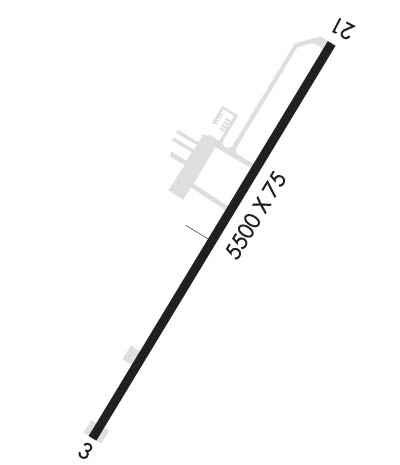
| Lat: N 3549.2 Long: W 08136.7 Elev: 1270 Var: +07 Longest Runway: 5500 | ||
| AWOS: 124.17 CTAF: 122.7 | ||
| ||||||
| ||||||
|
| Rwy | Rwy | |||||||
| 5500x75 | 5500' | 111.10 - 030° | 5500x75 | 5500' | ||||
| Runway ID | Single Wheel | Double Wheel | Double Tandem Wheel | Dual Double Wheel |
| 03/21 | N/A | 60,000 | N/A | N/A |
| These numbers are Advisory and are not limits. The Airport Manager should have more accurate Weight Limits | ||||
 Airport Diagram might not be current. | |
| Facility Name: | FOOTHILLS RGNL |
| City Name: | MORGANTON |
| County: | CALDWELL |
| State abbrev: | NC |
| State Name: | NORTH CAROLINA |
| Ownership: | PUBLICLY OWNED |
| Use: | OPEN TO THE PUBLIC |
| Owner's Name: | FOOTHILLS REGIONAL AIRPORT AUTHORIT |
| Address: | 3566 FOOTHILLS AIRPORT RD |
| MORGANTON, NC 28655 | |
| Owner's Phone: | 828-757-0099 |
| Manager's Name: | BRENT BRINKLEY |
| Address: | 3566 FOOTHILLS AIRPORT RD |
| MORGANTON, NC 28655 | |
| Phone: | 828-757-0099 |
| FAA Region: | SOUTHERN |
| FAA Field Office: | MEM |

| Date | Sunrise | Sunset |
|---|---|---|
| 09/24/21 Friday | 7:16 | 19:21 |
| 09/25/21 Saturday | 7:16 | 19:19 |
| 09/26/21 Sunday | 7:17 | 19:18 |
| 09/27/21 Monday | 7:18 | 19:16 |
| 09/28/21 Tuesday | 7:19 | 19:15 |
| 09/29/21 Wednesday | 7:20 | 19:13 |
| 09/30/21 Thursday | 7:20 | 19:12 |
| 10/01/21 Friday | 7:21 | 19:10 |
| 10/02/21 Saturday | 7:22 | 19:09 |
| 10/03/21 Sunday | 7:23 | 19:08 |
| 10/04/21 Monday | 7:24 | 19:06 |
| 10/05/21 Tuesday | 7:24 | 19:05 |
| 10/06/21 Wednesday | 7:25 | 19:03 |
| 10/07/21 Thursday | 7:26 | 19:02 |
| Airport Attendance Schedule | MON-SAT 0800-1700, SUN 0900-1700 |
| Airport Status | OPERATIONAL (This Status can change at any time - please check NOTAMS) |
| Airport Lighting Schedule | ACTVT MIRL RY 03/21, REILS RYS 03 & 21, PAPIS RYS 03 & 21 - CTAF. |
| Airport Storage Available | Tie Downs, Hanger |
| Extra Services Available | Air Freight, Cargo Handling, Glider, Flight Instruction, Aircraft Rental, Aircraft Sales, Glider Towing |
| Wind Indicator | YES - (lighted) |
| Control Tower | NO |
| CTAF Frequency | 122.700 |
| Unicom Frequency | 122.700 |
| Rotating Beacon Color | CLEAR-GREEN (Light Land Airport) |
| Segmented Circle | YES |
| Landing Fee | NO |
| Airport Inspected | STATE - performed by STATE AERONAUTICAL PERSONNEL |
| Inspection Date | 08/29/2020 |
| Type of Fuel Available | Grade 100LL, JET A-1 (icing inhibitor, freeze point -50C); -10AFTER HOURS FUEL OR SERVICE CALL 828-757-0099 |
| Airframe Repair Service | MAJOR |
| Power Plant Repair Service | MAJOR |
| Latitude | N3549.2 |
| Longitude | W08136.7 (ESTIMATED) |
| Arpt Elevation | 1269ft (SURVEYED) |
| Magnetic Variation | 07W |
| 6 miles NE | of MORGANTON |
| Traffic Pattern Altitude | |
| Sectional Chart | CHARLOTTE |
| Operations (Reported) | Yearly | Avg. Daily |
|---|---|---|
| General Aviation Transient | 6500 | 18 |
| General Aviation Local | 9000 | 25 |
| Air Taxi | 1000 | 3 |
| Commerical | 0 | 0 |
| Commuter | 0 | 0 |
| Military | 500 | 1 |
| Aircraft based on Field | |
|---|---|
| General Aviation Singles | 56 |
| General Aviation Multi | 3 |
| Jet Aircraft | 0 |
| General Aviation Helicopters | 0 |
| Military Aircraft | 0 |
| Gliders | 0 |
| Ultralights | 0 |
| FSS on field | NO |
| FSS tie-in | RALEIGH |
| FSS Phone | 1-800-WX-BRIEF |
| Who issues Notams | MRN |
| Notam D service at airport | YES |
| ARTCC Name | ATLANTA |
| Airport Certification | |
| Aircraft Rescue & Firefighting Index | None |
| Airport of Entry | No |
| Custom Landing Rights | No |
| Joint Civil/Military | No |
| Military Landing rights | YES |
| NATIONAL PLAN OF INTEGRATED AIRPORT SYSTEMS (NPIAS) |
| GRANT AGREEMENTS UNDER FAAP/ADAP/AIP |
| ASSURANCES PURSUANT TO TITLE VI, CIVIL RIGHTS ACT OF 1964 |
| RY 03, 100 FT DROPOFF 330 FT FM THLD AND 80 FT BOTH SIDES OF CNTRLN ALONG FIRST 1000 FT OF RY. |
| RY 21, 30 FT DROPOFF 400 FT FM THLD BOTH SIDES AND 10 FT DROPOFF 50 FT FM THLD AND 150 FT RIGHT OF CNTRLN. |
| HANG GLIDER ACTVTY DALGT HRS. |
| DEER & COYOTE ON & INVOF ARPT. |
| FOR CD CTC ATLANTA ARTCC AT 770-210-7692. |
Airport Communications & Frequencies:
| |||||||||
| Runway: 03 | Runway: 21 | ||
| Mag heading: | 31° | Mag heading: | 211° |
| Rwy Slope: | .72% Up | Rwy Slope: | -.72% Down |
| Approach: | LOCALIZER | Approach: | |
| Pattern: | Left Traffic | Pattern: | Left Traffic |
| Markings: | NONPRECISION INSTRUMENT | Markings: | NONPRECISION INSTRUMENT |
| Marking Condition: | GOOD | Marking Condition: | GOOD |
| Arresting Dev: | Arresting Dev: | ||
| Lat & Long: | N3548.8 W08136.9 | Lat. & Long.: | N3549.6 W08136.5 |
| Elev: | 1230.2 ft. MSL | Elev: | 1269.7 ft. MSL |
| TCH: | 66 ft. AGL | TCH: | 48 ft. AGL |
| Visual Glide Path: | 3.00 degrees | Visual Glide Path: | 3.50 degrees |
| Displaced Threshold: | No | Displaced Threshold: | No |
| Touchdown Zone: | YES | Touchdown Zone: | YES |
| Touchdown Elev.: | 1247.8 feet | Touchdown Elev.: | 1269.9 feet |
| Visual Glide Slope: | 4-Light PAPI on LEFT side of Runway | Visual Glide Slope: | 4-Light PAPI on RIGHT side of Runway |
| RVR Equipment: | RVR Equipment: | ||
| RVV Equipment: | NO | RVV Equipment: | NO |
| Approach Lights: | Approach Lights: | ||
| REIL: | YES | REIL: | YES |
| Centerline Lights: | NO | Centerline Lights: | NO |
| Touchdown lights: | NO | Touchdown lights: | NO |
| Runway Category: | Runway with a Non-precision Approach having visibility minimums greater than 3/4 mile | Runway Category: | Runway with a Non-precision Approach having visibility minimums greater than 3/4 mile |
| Declared Distances: | Declared Distances: | ||
| Obstructions: | TREES | Obstructions: | TREES |
| Marked: | NOT Marked/Lighted | Marked: | NOT Marked/Lighted |
| Clearance slope: | 48:1 | Clearance slope: | 18:1 |
| Obstruction height: | 57 feet AGL | Obstruction height: | 18 feet AGL |
| Dist. from runway: | 2988 feet | Dist. from runway: | 535 feet |
| Centerline offset: | 261 right of centerline | Centerline offset: | 164 feet left of centerline |
| Comments: | Comments: |
Thanks for using FltPlan.com
all rights reserved © 1999-2021 by Flight Plan LLC