
| MARFA MUNI MARFA TX |
| |
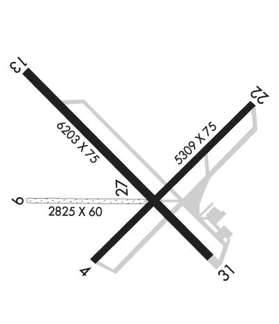
| Lat: N 3022.3 Long: W 10401.1 Elev: 4849 Var: -08 Longest Runway: 6203 | ||
| AWOS: 134.02 CTAF: 122.8 | ||
| ||||||||||||||||||||||||||||||||||||||||||||
| ||||||||||||||||||||||||||||||||||||||||||||
| ||||||||||||||||||||||||||||||||||||||||||||
| Rwy | Rwy | |||||||
| 5309x75 | 5309' | 5309x75 | 5309' | |||||
| 2825x60 | 2825' | 2825x60 | 2825' | |||||
| 6203x75 | 6203' | 6203x75 | 6203' | |||||
| Runway ID | Single Wheel | Double Wheel | Double Tandem Wheel | Dual Double Wheel |
| 04/22 | 18,000 | N/A | N/A | N/A |
| 09/27 | N/A | N/A | N/A | N/A |
| 13/31 | 18,000 | N/A | N/A | N/A |
| These numbers are Advisory and are not limits. The Airport Manager should have more accurate Weight Limits | ||||
 Airport Diagram might not be current. | |
| Facility Name: | MARFA MUNI |
| City Name: | MARFA |
| County: | PRESIDIO |
| State abbrev: | TX |
| State Name: | TEXAS |
| Ownership: | PUBLICLY OWNED |
| Use: | OPEN TO THE PUBLIC |
| Owner's Name: | PRESIDIO COUNTY |
| Address: | P.O. BOX 606 |
| MARFA, TX 79843 | |
| Owner's Phone: | 432-729-4452 |
| Manager's Name: | RUDY ESTOR |
| Address: | 45101 SH 17 |
| MARFA, TX 79843 | |
| Phone: | 432-295-3906 |
| FAA Region: | SOUTHWEST |
| FAA Field Office: | TEX |
| Date | Sunrise | Sunset |
|---|---|---|
| 06/07/26 Sunday | 6:54 | 20:56 |
| 06/08/26 Monday | 6:54 | 20:57 |
| 06/09/26 Tuesday | 6:53 | 20:57 |
| 06/10/26 Wednesday | 6:53 | 20:58 |
| 06/11/26 Thursday | 6:53 | 20:58 |
| 06/12/26 Friday | 6:53 | 20:58 |
| 06/13/26 Saturday | 6:53 | 20:59 |
| 06/14/26 Sunday | 6:54 | 20:59 |
| 06/15/26 Monday | 6:54 | 20:59 |
| 06/16/26 Tuesday | 6:54 | 21:00 |
| 06/17/26 Wednesday | 6:54 | 21:00 |
| 06/18/26 Thursday | 6:54 | 21:00 |
| 06/19/26 Friday | 6:54 | 21:01 |
| 06/20/26 Saturday | 6:54 | 21:01 |
| Airport Attendance Schedule | 7 Days A Week 0800-1600 |
| Airport Status | OPERATIONAL (This Status can change at any time - please check NOTAMS) |
| Airport Lighting Schedule | MIRL RWY 13/31 PRESET LOW INTST; TO INCR INTST ACTVT - CTAF. |
| Airport Storage Available | Tie Downs |
| Extra Services Available | Flight Instruction, Glider Towing |
| Wind Indicator | YES - (lighted) |
| Control Tower | NO |
| CTAF Frequency | 122.800 |
| Unicom Frequency | 122.800 |
| Rotating Beacon Color | WG |
| Segmented Circle | YES |
| Landing Fee | YES; LDG FEE WAIVED WITH MIN FUEL PURCHASE. |
| Airport Inspected | STATE - performed by PRIVATE CONTRACT PERSONNEL |
| Inspection Date | 03/09/2024 |
| Type of Fuel Available | Grade 100LL, JET A (freeze point -40C); -10100LL, JET-A, SELF SERVE AVLBL 24 HRS. |
| Airframe Repair Service | NONE |
| Power Plant Repair Service | NONE |
| Latitude | N3022.3 |
| Longitude | W10401.1 (ESTIMATED) |
| Arpt Elevation | 4848ft (SURVEYED) |
| Magnetic Variation | 08E |
| 3 miles N | of MARFA |
| Traffic Pattern Altitude | |
| Sectional Chart | EL PASO |
| Operations (Reported) | Yearly | Avg. Daily |
|---|---|---|
| General Aviation Transient | 0 | 0 |
| General Aviation Local | 0 | 0 |
| Air Taxi | 0 | 0 |
| Commerical | 0 | 0 |
| Commuter | 0 | 0 |
| Military | 0 | 0 |
| Aircraft based on Field | |
|---|---|
| General Aviation Singles | 0 |
| General Aviation Multi | 0 |
| Jet Aircraft | 0 |
| General Aviation Helicopters | 0 |
| Military Aircraft | 0 |
| Gliders | 0 |
| Ultralights | 0 |
| FSS on field | NO |
| FSS tie-in | SAN ANGELO |
| FSS Phone | 1-800-WX-BRIEF |
| Who issues Notams | MRF |
| Notam D service at airport | YES |
| ARTCC Name | ALBUQUERQUE |
| Airport Certification | |
| Aircraft Rescue & Firefighting Index | None |
| Airport of Entry | No |
| Custom Landing Rights | No |
| Joint Civil/Military | No |
| Military Landing rights | YES |
| NATIONAL PLAN OF INTEGRATED AIRPORT SYSTEMS (NPIAS) |
| GRANT AGREEMENTS UNDER FAAP/ADAP/AIP |
| ASSURANCES PURSUANT TO TITLE VI, CIVIL RIGHTS ACT OF 1964 |
| AGREEMENT UNDER DLAND OR DCLA HAS EXPIRED. |
| 105 FT AGL LGTD WATER TWR 1168 FT SW OF AER 31. |
| GLIDER OPNS ON & INVOF ARPT. |
| WILDLIFE ON & INVOF ARPT. |
| PARL TWY ADJ RWY 04/22 CLSD EXC BTN TWY A AND RWY 13/31. |
| FOR CD IF UNA TO CTC ON FSS FREQ, CTC ALBUQUERQUE ARTCC AT 505-856-4561. |
| TWY A NORTHWEST OF RWY 04/22 CLSD TO ACFT MORE THAN 18000 LB. |
| RWY 9 THLD MKD W/3 WHITE TIRES EACH SIDE OF RWY CNTRLN. |
Airport Communications & Frequencies:
| |||||||||
| Runway: 04 | Runway: 22 | ||
| Mag heading: | 37° | Mag heading: | 217° |
| Rwy Slope: | .40% Up | Rwy Slope: | -.40% Down |
| Approach: | Approach: | ||
| Pattern: | Left Traffic | Pattern: | Left Traffic |
| Markings: | BASIC | Markings: | BASIC |
| Marking Condition: | GOOD | Marking Condition: | GOOD |
| Arresting Dev: | Arresting Dev: | ||
| Lat & Long: | N3021.9 W10401.2 | Lat. & Long.: | N3022.6 W10400.5 |
| Elev: | 4827.2 ft. MSL | Elev: | 4848.7 ft. MSL |
| TCH: | TCH: | ||
| Visual Glide Path: | Visual Glide Path: | ||
| Displaced Threshold: | No | Displaced Threshold: | No |
| Touchdown Zone: | YES | Touchdown Zone: | YES |
| Touchdown Elev.: | 4838.5 feet | Touchdown Elev.: | 4848.8 feet |
| Visual Glide Slope: | Visual Glide Slope: | ||
| RVR Equipment: | RVR Equipment: | ||
| RVV Equipment: | NO | RVV Equipment: | NO |
| Approach Lights: | Approach Lights: | ||
| REIL: | NO | REIL: | NO |
| Centerline Lights: | NO | Centerline Lights: | NO |
| Touchdown lights: | NO | Touchdown lights: | NO |
| Runway Category: | Runway with a Visual Approach | Runway Category: | Runway with a Visual Approach |
| Declared Distances: | Declared Distances: | ||
| Comments: | 12 FT TREE, 24 FT DSTC, 230 FT R. | Comments: |
| Runway: 09 | Runway: 27 | ||
| Mag heading: | 83° | Mag heading: | 263° |
| Rwy Slope: | .21% Up | Rwy Slope: | -.21% Down |
| Approach: | Approach: | ||
| Pattern: | Left Traffic | Pattern: | Left Traffic |
| Markings: | Markings: | ||
| Marking Condition: | Marking Condition: | ||
| Arresting Dev: | Arresting Dev: | ||
| Lat & Long: | N3022.2 W10401.5 | Lat. & Long.: | N3022.2 W10401.0 |
| Elev: | 4828.7 ft. MSL | Elev: | 4834.5 ft. MSL |
| TCH: | TCH: | ||
| Visual Glide Path: | Visual Glide Path: | ||
| Displaced Threshold: | No | Displaced Threshold: | No |
| Touchdown Zone: | YES | Touchdown Zone: | YES |
| Touchdown Elev.: | 4834.5 feet | Touchdown Elev.: | 4834.5 feet |
| Visual Glide Slope: | Visual Glide Slope: | ||
| RVR Equipment: | RVR Equipment: | ||
| RVV Equipment: | NO | RVV Equipment: | NO |
| Approach Lights: | Approach Lights: | ||
| REIL: | NO | REIL: | NO |
| Centerline Lights: | NO | Centerline Lights: | NO |
| Touchdown lights: | NO | Touchdown lights: | NO |
| Runway Category: | Runway with a Visual Approach | Runway Category: | Runway with a Visual Approach |
| Declared Distances: | Declared Distances: | ||
| Obstructions: | FENCE | Obstructions: | |
| Marked: | NOT Marked/Lighted | Marked: | |
| Clearance slope: | 33:1 | Clearance slope: | 50:1 |
| Obstruction height: | 4 feet AGL | Obstruction height: | |
| Dist. from runway: | 132 feet | Dist. from runway: | |
| Centerline offset: | Centerline offset: | ||
| Comments: | Comments: |
| Runway: 13 | Runway: 31 | ||
| Mag heading: | 127° | Mag heading: | 307° |
| Rwy Slope: | -.17% Down | Rwy Slope: | .17% Up |
| Approach: | Approach: | ||
| Pattern: | Left Traffic | Pattern: | Left Traffic |
| Markings: | NONPRECISION INSTRUMENT | Markings: | NONPRECISION INSTRUMENT |
| Marking Condition: | GOOD | Marking Condition: | GOOD |
| Arresting Dev: | Arresting Dev: | ||
| Lat & Long: | N3022.7 W10401.5 | Lat. & Long.: | N3022.0 W10400.7 |
| Elev: | 4840.5 ft. MSL | Elev: | 4830.0 ft. MSL |
| TCH: | 40 ft. AGL | TCH: | 40 ft. AGL |
| Visual Glide Path: | 3.00 degrees | Visual Glide Path: | 3.00 degrees |
| Displaced Threshold: | No | Displaced Threshold: | No |
| Touchdown Zone: | YES | Touchdown Zone: | YES |
| Touchdown Elev.: | 4845.5 feet | Touchdown Elev.: | 4840.2 feet |
| Visual Glide Slope: | 2-Light PAPI on LEFT side of Runway | Visual Glide Slope: | 2-Light PAPI on LEFT side of Runway |
| RVR Equipment: | RVR Equipment: | ||
| RVV Equipment: | NO | RVV Equipment: | NO |
| Approach Lights: | Approach Lights: | ||
| REIL: | NO | REIL: | NO |
| Centerline Lights: | NO | Centerline Lights: | NO |
| Touchdown lights: | NO | Touchdown lights: | NO |
| Runway Category: | Runway with a Visual Approach | Runway Category: | Runway with a Non-precision Approach having visibility minimums greater than 3/4 mile |
| Declared Distances: | Declared Distances: | ||
| Obstructions: | Obstructions: | TREE | |
| Marked: | Marked: | NOT Marked/Lighted | |
| Clearance slope: | 50:1 | Clearance slope: | 35:1 |
| Obstruction height: | Obstruction height: | 19 feet AGL | |
| Dist. from runway: | Dist. from runway: | 870 feet | |
| Centerline offset: | Centerline offset: | 250 feet left of centerline | |
| Comments: | Comments: |
Thanks for using FltPlan.com
all rights reserved © 1999-2026 by Flight Plan LLC
