
| EDWARD F KNAPP STATE BARRE/MONTPELIER VT |
| |
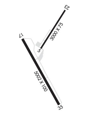
| Lat: N 4412.2 Long: W 07233.7 Elev: 1166 Var: +16 Longest Runway: 5000 | ||
| AWOS: 132.67 CTAF: 122.8 | ||
| ||||||||||||||||||||||||||||||||||||||||||||
| ||||||||||||||||||||||||||||||||||||||||||||
| ||||||||||||||||||||||||||||||||||||||||||||
| Rwy | Rwy | |||||||
| 3001x75 | 3001' | 3001x75 | 3001' | |||||
| 5000x100 | 5000' | 108.70 - 167° | 5000x100 | 4498' | ||||
| Runway ID | Single Wheel | Double Wheel | Double Tandem Wheel | Dual Double Wheel |
| 05/23 | 30,000 | 46,000 | N/A | N/A |
| 17/35 | 31,000 | 70,000 | N/A | N/A |
| These numbers are Advisory and are not limits. The Airport Manager should have more accurate Weight Limits | ||||
 Airport Diagram might not be current. | |
| Facility Name: | EDWARD F KNAPP STATE |
| City Name: | BARRE/MONTPELIER |
| County: | WASHINGTON |
| State abbrev: | VT |
| State Name: | VERMONT |
| Ownership: | PUBLICLY OWNED |
| Use: | OPEN TO THE PUBLIC |
| Owner's Name: | STATE OF VERMONT |
| Address: | 219 N MAIN ST |
| BARRE, VT 05641 | |
| Owner's Phone: | 802-279-7146 |
| Manager's Name: | CHRIS BEITZEL |
| Address: | 219 N MAIN ST |
| BARRE, VT 05641 | |
| Phone: | 802-272-7725 |
| FAA Region: | NEW ENGLAND |
| FAA Field Office: | NONE |
| Date | Sunrise | Sunset |
|---|---|---|
| 06/08/26 Monday | 5:07 | 20:32 |
| 06/09/26 Tuesday | 5:07 | 20:32 |
| 06/10/26 Wednesday | 5:06 | 20:33 |
| 06/11/26 Thursday | 5:06 | 20:34 |
| 06/12/26 Friday | 5:06 | 20:34 |
| 06/13/26 Saturday | 5:06 | 20:35 |
| 06/14/26 Sunday | 5:06 | 20:35 |
| 06/15/26 Monday | 5:06 | 20:36 |
| 06/16/26 Tuesday | 5:06 | 20:36 |
| 06/17/26 Wednesday | 5:06 | 20:36 |
| 06/18/26 Thursday | 5:06 | 20:37 |
| 06/19/26 Friday | 5:06 | 20:37 |
| 06/20/26 Saturday | 5:06 | 20:37 |
| 06/21/26 Sunday | 5:07 | 20:37 |
| Airport Attendance Schedule | 7 Days A Week 0800-1700 |
| Airport Status | OPERATIONAL (This Status can change at any time - please check NOTAMS) |
| Airport Lighting Schedule | ACTVT MALSR RWY 17; MIRL RWY 17/35 - CTAF. |
| Airport Storage Available | Tie Downs |
| Extra Services Available | Air Freight |
| Wind Indicator | YES - (unlit) |
| Control Tower | NO |
| CTAF Frequency | 122.800 |
| Unicom Frequency | 122.800; UNICOM BASE STN NOT MANNED CONSLY. |
| Rotating Beacon Color | WG |
| Segmented Circle | YES |
| Landing Fee | NO |
| Airport Inspected | STATE - performed by PRIVATE CONTRACT PERSONNEL |
| Inspection Date | 07/25/2025 |
| Type of Fuel Available | Grade 100LL, JET A |
| Airframe Repair Service | MAJOR |
| Power Plant Repair Service | MAJOR |
| Latitude | N4412.2 |
| Longitude | W07233.7 (ESTIMATED) |
| Arpt Elevation | 1165ft (SURVEYED) |
| Magnetic Variation | 16W |
| 3 miles W | of BARRE/MONTPELIER |
| Traffic Pattern Altitude | |
| Sectional Chart | MONTREAL |
| Operations (Reported) | Yearly | Avg. Daily |
|---|---|---|
| General Aviation Transient | 0 | 0 |
| General Aviation Local | 0 | 0 |
| Air Taxi | 0 | 0 |
| Commerical | 0 | 0 |
| Commuter | 0 | 0 |
| Military | 0 | 0 |
| Aircraft based on Field | |
|---|---|
| General Aviation Singles | 0 |
| General Aviation Multi | 0 |
| Jet Aircraft | 0 |
| General Aviation Helicopters | 0 |
| Military Aircraft | 0 |
| Gliders | 0 |
| Ultralights | 0 |
| FSS on field | NO |
| FSS tie-in | BURLINGTON |
| FSS Phone | 1-800-WX-BRIEF |
| Who issues Notams | MPV |
| Notam D service at airport | YES |
| ARTCC Name | BOSTON |
| Airport Certification | |
| Aircraft Rescue & Firefighting Index | None |
| Airport of Entry | No |
| Custom Landing Rights | No |
| Joint Civil/Military | No |
| Military Landing rights | YES |
| NATIONAL PLAN OF INTEGRATED AIRPORT SYSTEMS (NPIAS) |
| GRANT AGREEMENTS UNDER FAAP/ADAP/AIP |
| ASSURANCES PURSUANT TO TITLE VI, CIVIL RIGHTS ACT OF 1964 |
| AGREEMENT UNDER DLAND OR DCLA HAS EXPIRED. |
| FLD COND NOT MON WHEN UNATNDD. |
| COLD TEMPERATURE AIRPORT. ALTITUDE CORRECTION REQUIRED AT OR BELOW -19C. |
| FOR CD IF UNA TO CTC ON FSS FREQ, CTC BOSTON ARTCC AT 603-879-6859 . |
Airport Communications & Frequencies:
| |||||||||
| Runway: 05 | Runway: 23 | ||
| Mag heading: | 48° | Mag heading: | 228° |
| Rwy Slope: | -1.03% Down | Rwy Slope: | 1.03% Up |
| Approach: | Approach: | ||
| Pattern: | Left Traffic | Pattern: | Left Traffic |
| Markings: | BASIC | Markings: | BASIC |
| Marking Condition: | GOOD | Marking Condition: | GOOD |
| Arresting Dev: | Arresting Dev: | ||
| Lat & Long: | N4412.3 W07233.8 | Lat. & Long.: | N4412.7 W07233.4 |
| Elev: | 1115.5 ft. MSL | Elev: | 1084.7 ft. MSL |
| TCH: | TCH: | ||
| Visual Glide Path: | Visual Glide Path: | ||
| Displaced Threshold: | No | Displaced Threshold: | No |
| Touchdown Zone: | YES | Touchdown Zone: | YES |
| Touchdown Elev.: | 1115.5 feet | Touchdown Elev.: | 1115.5 feet |
| Visual Glide Slope: | Visual Glide Slope: | ||
| RVR Equipment: | RVR Equipment: | ||
| RVV Equipment: | NO | RVV Equipment: | NO |
| Approach Lights: | Approach Lights: | ||
| REIL: | NO | REIL: | NO |
| Centerline Lights: | NO | Centerline Lights: | NO |
| Touchdown lights: | NO | Touchdown lights: | NO |
| Runway Category: | Runway with a Visual Approach | Runway Category: | Runway with a Visual Approach |
| Declared Distances: | Declared Distances: |
| Runway: 17 | Runway: 35 | ||
| Mag heading: | 168° | Mag heading: | 348° |
| Rwy Slope: | 1.48% Up | Rwy Slope: | -1.48% Down |
| Approach: | ILS/DME | Approach: | |
| Pattern: | Left Traffic | Pattern: | Left Traffic |
| Markings: | PRECISION INSTRUMENT | Markings: | NONPRECISION INSTRUMENT |
| Marking Condition: | GOOD | Marking Condition: | GOOD |
| Arresting Dev: | Arresting Dev: | ||
| Lat & Long: | N4412.4 W07234.1 | Lat. & Long.: | N4411.7 W07233.5 |
| Elev: | 1091.5 ft. MSL | Elev: | 1165.6 ft. MSL |
| TCH: | 46 ft. AGL | TCH: | |
| Visual Glide Path: | 3.00 degrees | Visual Glide Path: | |
| Displaced Threshold: | No | Displaced Threshold: | 502 feet |
| Touchdown Zone: | YES | Touchdown Zone: | YES |
| Touchdown Elev.: | 1135.4 feet | Touchdown Elev.: | 1158.0 feet |
| Visual Glide Slope: | 4-Light PAPI on LEFT side of Runway | Visual Glide Slope: | |
| RVR Equipment: | RVR Equipment: | ||
| RVV Equipment: | NO | RVV Equipment: | NO |
| Approach Lights: | MALSR - 1,400 foot medium intensity approach lighting system with runway alignment indicator lights | Approach Lights: | |
| REIL: | NO | REIL: | YES |
| Centerline Lights: | NO | Centerline Lights: | NO |
| Touchdown lights: | NO | Touchdown lights: | NO |
| Runway Category: | Precision Instrument Runway | Runway Category: | Runway with a Non-precision Approach having visibility minimums greater than 3/4 mile |
| Declared Distances: | Declared Distances: | ||
| Obstructions: | TREES; 52 FT TREE, 1125 FT FM DTHR, 250 FT L, OBSTN CLNC SLP 17:1. | Obstructions: | ANT; 160 FT TREE, 1200 FT FM DTHR, 140 FT L. OBSTN CLNC SLP 15:1. |
| Marked: | NOT Marked/Lighted | Marked: | NOT Marked/Lighted |
| Clearance slope: | 6:1; CLNC SLP 0:1 TO RWY 17 DTHR DUE TO 6 FT FENCE ON 6 FT HILL, 240 FT LEFT OF CNTRLN. | Clearance slope: | 4:1 |
| Obstruction height: | 35 feet AGL | Obstruction height: | 14 feet AGL |
| Dist. from runway: | 415 feet | Dist. from runway: | 262 feet |
| Centerline offset: | 290 left of centerline | Centerline offset: | 197 feet right of centerline |
| Comments: | Comments: |
Thanks for using FltPlan.com
all rights reserved © 1999-2026 by Flight Plan LLC
