
| PETIT JEAN PARK MORRILTON AR |
| |
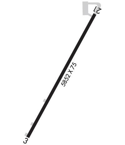
| Lat: N 3508.3 Long: W 09254.6 Elev: 923 Var: -03 Longest Runway: 5852 | ||
| CTAF: 122.9 | ||
| ||||||
|
| Rwy | Rwy | |||||||
| 5852x75 | 5414' | 5852x75 | 5662' | |||||
| Runway ID | Single Wheel | Double Wheel | Double Tandem Wheel | Dual Double Wheel |
| 03/21 | 17,000 | N/A | N/A | N/A |
| These numbers are Advisory and are not limits. The Airport Manager should have more accurate Weight Limits | ||||
 Airport Diagram might not be current. | |
| Facility Name: | PETIT JEAN PARK |
| City Name: | MORRILTON |
| County: | CONWAY |
| State abbrev: | AR |
| State Name: | ARKANSAS |
| Ownership: | PUBLICLY OWNED |
| Use: | OPEN TO THE PUBLIC |
| Owner's Name: | STATE OF ARKANSAS |
| Address: | ONE CAPITOL MALL |
| LITTLE ROCK, AR 72201 | |
| Owner's Phone: | (501) 727-5441 |
| Manager's Name: | CHRIS FINKBEINER |
| Address: | 1285 PETIT JEAN MOUNTAIN RD. |
| MORRILTON, AR 72110 | |
| Phone: | (501) 374-5022 |
| FAA Region: | SOUTHWEST |
| FAA Field Office: | AOK |
| Date | Sunrise | Sunset |
|---|---|---|
| 09/24/21 Friday | 7:01 | 19:06 |
| 09/25/21 Saturday | 7:02 | 19:04 |
| 09/26/21 Sunday | 7:02 | 19:03 |
| 09/27/21 Monday | 7:03 | 19:02 |
| 09/28/21 Tuesday | 7:04 | 19:00 |
| 09/29/21 Wednesday | 7:05 | 18:59 |
| 09/30/21 Thursday | 7:05 | 18:57 |
| 10/01/21 Friday | 7:06 | 18:56 |
| 10/02/21 Saturday | 7:07 | 18:54 |
| 10/03/21 Sunday | 7:08 | 18:53 |
| 10/04/21 Monday | 7:09 | 18:52 |
| 10/05/21 Tuesday | 7:09 | 18:50 |
| 10/06/21 Wednesday | 7:10 | 18:49 |
| 10/07/21 Thursday | 7:11 | 18:47 |
| Airport Attendance Schedule | UNATTENDED; FOR SERVICE CALL 501-374-5022. |
| Airport Status | OPERATIONAL (This Status can change at any time - please check NOTAMS) |
| Airport Lighting Schedule | ACTVT MIRL RWY 03/21, PAPI RWYS 03 & 21 - CTAF. PAPI RWYS 03 & 21 UNAVBL 2200-0400.; ACTVT ROTG BCN - CTAF. BCN UNAVBL 2200-0400. |
| Airport Storage Available | Tie Downs |
| Extra Services Available | Charter |
| Wind Indicator | YES - (unlit) |
| Control Tower | NO |
| CTAF Frequency | 122.900 |
| Unicom Frequency | |
| Rotating Beacon Color | CLEAR-GREEN (Light Land Airport) |
| Segmented Circle | NO |
| Landing Fee | NO |
| Airport Inspected | STATE - performed by STATE AERONAUTICAL PERSONNEL |
| Inspection Date | 02/13/2019 |
| Type of Fuel Available | Grade 100LL, JET A (freeze point -40C); -10SELF SVC FUEL AVBL 24 HR WITH CREDIT CARD (100LL & JET A). |
| Airframe Repair Service | None |
| Power Plant Repair Service | None |
| Latitude | N3508.3 |
| Longitude | W09254.6 (ESTIMATED) |
| Arpt Elevation | 923ft (SURVEYED) |
| Magnetic Variation | 03E |
| 8 miles W | of MORRILTON |
| Traffic Pattern Altitude | |
| Sectional Chart | MEMPHIS |
| Operations (Reported) | Yearly | Avg. Daily |
|---|---|---|
| General Aviation Transient | 2000 | 5 |
| General Aviation Local | 0 | 0 |
| Air Taxi | 0 | 0 |
| Commerical | 0 | 0 |
| Commuter | 0 | 0 |
| Military | 50 | 0 |
| Aircraft based on Field | |
|---|---|
| General Aviation Singles | 0 |
| General Aviation Multi | 3 |
| Jet Aircraft | 0 |
| General Aviation Helicopters | 0 |
| Military Aircraft | 0 |
| Gliders | 0 |
| Ultralights | 0 |
| FSS on field | NO |
| FSS tie-in | JONESBORO |
| FSS Phone | 1-800-WX-BRIEF |
| Who issues Notams | JBR |
| Notam D service at airport | YES |
| ARTCC Name | MEMPHIS |
| Airport Certification | |
| Aircraft Rescue & Firefighting Index | None |
| Airport of Entry | No |
| Custom Landing Rights | No |
| Joint Civil/Military | No |
| Military Landing rights | YES |
| NATIONAL PLAN OF INTEGRATED AIRPORT SYSTEMS (NPIAS) |
| GRANT AGREEMENT HAS EXPIRED; HOWEVER, AGREEMENT REMAINS IN EFFECT FOR THIS FACILITY AS LONG AS IT IS PUBLIC USE. |
| ULTRALIGHT ACTIVITY ON & INVOF ARPT |
| DEER & MIGRATORY BIRDS ON & INVOF ARPT. |
| FOR CD CTC MEMPHIS ARTCC AT 901-368-8453/8449. |
| RWY 03/2 1 MIRL RWY 03/21 OTS INDEFLY. |
Airport Communications & Frequencies:
| |||||||
| Runway: 03 | Runway: 21 | ||
| Mag heading: | 26° | Mag heading: | 206° |
| Rwy Slope: | .58% Up | Rwy Slope: | -.58% Down |
| Approach: | Approach: | ||
| Pattern: | Left Traffic | Pattern: | Left Traffic |
| Markings: | NONPRECISION INSTRUMENT | Markings: | BASIC |
| Marking Condition: | GOOD | Marking Condition: | GOOD |
| Arresting Dev: | Arresting Dev: | ||
| Lat & Long: | N3507.9 W09254.8 | Lat. & Long.: | N3508.8 W09254.3 |
| Elev: | 888.8 ft. MSL | Elev: | 923.0 ft. MSL |
| TCH: | 50 ft. AGL | TCH: | 44 ft. AGL |
| Visual Glide Path: | 4.00 degrees | Visual Glide Path: | 4.00 degrees |
| Displaced Threshold: | 438 feet | Displaced Threshold: | 190 feet |
| Touchdown Zone: | YES | Touchdown Zone: | YES |
| Touchdown Elev.: | 902.2 feet | Touchdown Elev.: | 922.1 feet |
| Visual Glide Slope: | 2-Light PAPI on RIGHT side of Runway; PAPI RWY 03/21 OTS INDEFLY. | Visual Glide Slope: | 2-Light PAPI on LEFT side of Runway |
| RVR Equipment: | RVR Equipment: | ||
| RVV Equipment: | NO | RVV Equipment: | NO |
| Approach Lights: | Approach Lights: | ||
| REIL: | NO | REIL: | NO |
| Centerline Lights: | NO | Centerline Lights: | NO |
| Touchdown lights: | NO | Touchdown lights: | NO |
| Runway Category: | Runway with a Non-precision Approach having visibility minimums greater than 3/4 mile | Runway Category: | Runway with a Visual Approach |
| Declared Distances: | Declared Distances: | ||
| Obstructions: | TREES | Obstructions: | TREES |
| Marked: | NOT Marked/Lighted | Marked: | NOT Marked/Lighted |
| Clearance slope: | 14:1; APCH RATIO 20:1 FM DSPLCD THLD. | Clearance slope: | 4:1; APCH RATIO 13:1 FM DSPLCD THLD. |
| Obstruction height: | 95 feet AGL | Obstruction height: | 40 feet AGL |
| Dist. from runway: | 1530 feet | Dist. from runway: | 360 feet |
| Centerline offset: | Centerline offset: | 200 feet right of centerline | |
| Comments: | 3 FT FENCE 50 FT FROM RY END. | Comments: |
Thanks for using FltPlan.com
all rights reserved © 1999-2021 by Flight Plan LLC
