
| MARIPOSA-YOSEMITE MARIPOSA CA |
| |
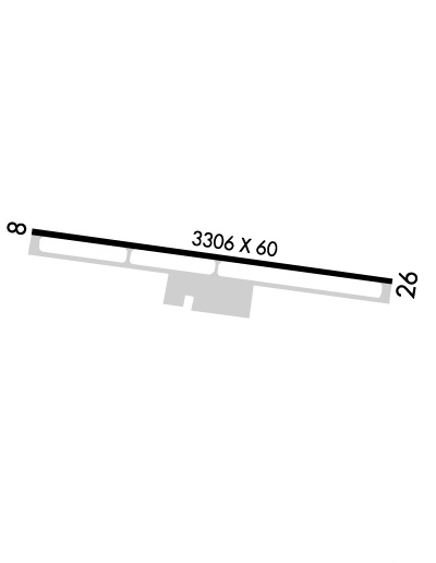
| Lat: N 3730.7 Long: W 12002.4 Elev: 2254 Var: -15 Longest Runway: 3305 | ||
| AWOS: 135.6 CTAF: 122.7 | ||
| ||||||||||||||||||||||||||||||||||||||||||||
| ||||||||||||||||||||||||||||||||||||||||||||
| ||||||||||||||||||||||||||||||||||||||||||||
| Rwy | Rwy | |||||||
| 3305x60 | 3305' | 3305x60 | 3305' | |||||
| Runway ID | Single Wheel | Double Wheel | Double Tandem Wheel | Dual Double Wheel |
| 08/26 | 12,000 | N/A | N/A | N/A |
| These numbers are Advisory and are not limits. The Airport Manager should have more accurate Weight Limits | ||||
 Airport Diagram might not be current. | |
| Facility Name: | MARIPOSA-YOSEMITE |
| City Name: | MARIPOSA |
| County: | MARIPOSA |
| State abbrev: | CA |
| State Name: | CALIFORNIA |
| Ownership: | PUBLICLY OWNED |
| Use: | OPEN TO THE PUBLIC |
| Owner's Name: | COUNTY OF MARIPOSA |
| Address: | 4639 BEN HUR ROAD |
| MARIPOSA, CA 95338 | |
| Owner's Phone: | 209-966-5356 |
| Manager's Name: | ANTHONY BORRESON; WWW.YOSEMITEAVIATION.COM |
| Address: | 5020 MACREADY WAY |
| MARIPOSA, CA 95338 | |
| Phone: | (209) 966-2143 |
| FAA Region: | WESTERN-PACIFIC |
| FAA Field Office: | SFO |

| Date | Sunrise | Sunset |
|---|---|---|
| 09/24/21 Friday | 6:49 | 18:54 |
| 09/25/21 Saturday | 6:50 | 18:53 |
| 09/26/21 Sunday | 6:51 | 18:51 |
| 09/27/21 Monday | 6:52 | 18:50 |
| 09/28/21 Tuesday | 6:53 | 18:48 |
| 09/29/21 Wednesday | 6:54 | 18:47 |
| 09/30/21 Thursday | 6:55 | 18:45 |
| 10/01/21 Friday | 6:56 | 18:44 |
| 10/02/21 Saturday | 6:56 | 18:42 |
| 10/03/21 Sunday | 6:57 | 18:40 |
| 10/04/21 Monday | 6:58 | 18:39 |
| 10/05/21 Tuesday | 6:59 | 18:38 |
| 10/06/21 Wednesday | 7:00 | 18:36 |
| 10/07/21 Thursday | 7:01 | 18:35 |
| Airport Attendance Schedule | MON-FRI 1000-1600, SAT-SUN 1000-1400 |
| Airport Status | OPERATIONAL (This Status can change at any time - please check NOTAMS) |
| Airport Lighting Schedule | ACTVT PAPI RWY 08 & 26; MIRL RWY 08/26 - CTAF. |
| Airport Storage Available | Tie Downs |
| Extra Services Available | Flight Instruction, Parachute Jumping, Aircraft Rental, Aircraft Sales |
| Wind Indicator | YES - (lighted) |
| Control Tower | NO |
| CTAF Frequency | 122.700 |
| Unicom Frequency | 122.700 |
| Rotating Beacon Color | CLEAR-GREEN (Light Land Airport) |
| Segmented Circle | YES |
| Landing Fee | NO |
| Airport Inspected | STATE - performed by STATE AERONAUTICAL PERSONNEL |
| Inspection Date | 06/13/2019 |
| Type of Fuel Available | Grade 100LL, JET A (freeze point -40C); -10FUEL AVBL 24 HRS WITH CREDIT CARD. |
| Airframe Repair Service | MINOR |
| Power Plant Repair Service | MINOR |
| Latitude | N3730.7 |
| Longitude | W12002.4 (ESTIMATED) |
| Arpt Elevation | 2254ft (SURVEYED) |
| Magnetic Variation | 15E |
| 4 miles W | of MARIPOSA |
| Traffic Pattern Altitude | |
| Sectional Chart | SAN FRANCISCO |
| Operations (Reported) | Yearly | Avg. Daily |
|---|---|---|
| General Aviation Transient | 3150 | 9 |
| General Aviation Local | 6300 | 17 |
| Air Taxi | 108 | 0 |
| Commerical | 0 | 0 |
| Commuter | 0 | 0 |
| Military | 0 | 0 |
| Aircraft based on Field | |
|---|---|
| General Aviation Singles | 15 |
| General Aviation Multi | 0 |
| Jet Aircraft | 0 |
| General Aviation Helicopters | 0 |
| Military Aircraft | 0 |
| Gliders | 0 |
| Ultralights | 0 |
| FSS on field | NO |
| FSS tie-in | RANCHO MURIETA |
| FSS Phone | 1-800-WX-BRIEF |
| Who issues Notams | RIU |
| Notam D service at airport | YES |
| ARTCC Name | OAKLAND |
| Airport Certification | |
| Aircraft Rescue & Firefighting Index | None |
| Airport of Entry | No |
| Custom Landing Rights | No |
| Joint Civil/Military | No |
| Military Landing rights | YES |
| NATIONAL PLAN OF INTEGRATED AIRPORT SYSTEMS (NPIAS) |
| GRANT AGREEMENTS UNDER FAAP/ADAP/AIP |
| ASSURANCES PURSUANT TO TITLE VI, CIVIL RIGHTS ACT OF 1964 |
| TRANSITIONAL SURFACE OBSTRUCTION: MOUNTAINS TO NORTH OF RWY 08/26. |
| RY 08 TERRAIN DROPS ALONG BOTH SIDES OF TWY 45 FT FM RY EDGE. |
| BIRDS ON AND INVOF ARPT. |
| FOR CD CTC OAKLAND ARTCC AT 510-745-3380. |
Airport Communications & Frequencies:
| |||||||||
| Runway: 08 | Runway: 26 | ||
| Mag heading: | 85° | Mag heading: | 265° |
| Rwy Slope: | -.95% Down | Rwy Slope: | .95% Up |
| Approach: | Approach: | ||
| Pattern: | Right Traffic | Pattern: | Left Traffic |
| Markings: | NONPRECISION INSTRUMENT | Markings: | NONPRECISION INSTRUMENT |
| Marking Condition: | GOOD | Marking Condition: | GOOD |
| Arresting Dev: | Arresting Dev: | ||
| Lat & Long: | N3730.7 W12002.7 | Lat. & Long.: | N3730.6 W12002.0 |
| Elev: | 2254.2 ft. MSL | Elev: | 2222.9 ft. MSL |
| TCH: | 36 ft. AGL | TCH: | 40 ft. AGL |
| Visual Glide Path: | 4.00 degrees | Visual Glide Path: | 4.50 degrees |
| Displaced Threshold: | No | Displaced Threshold: | No |
| Touchdown Zone: | YES | Touchdown Zone: | YES |
| Touchdown Elev.: | 2254.2 feet | Touchdown Elev.: | 2250.8 feet |
| Visual Glide Slope: | 2-Light PAPI on LEFT side of Runway | Visual Glide Slope: | 2-Light PAPI on LEFT side of Runway |
| RVR Equipment: | RVR Equipment: | ||
| RVV Equipment: | NO | RVV Equipment: | NO |
| Approach Lights: | Approach Lights: | ||
| REIL: | NO | REIL: | NO |
| Centerline Lights: | NO | Centerline Lights: | NO |
| Touchdown lights: | NO | Touchdown lights: | NO |
| Runway Category: | Runway with a Visual Approach | Runway Category: | Runway with a Visual Approach |
| Declared Distances: | Declared Distances: | ||
| Obstructions: | TREE | Obstructions: | TREE |
| Marked: | NOT Marked/Lighted | Marked: | NOT Marked/Lighted |
| Clearance slope: | 25:1 | Clearance slope: | 20:1 |
| Obstruction height: | 45 feet AGL | Obstruction height: | 29 feet AGL |
| Dist. from runway: | 1340 feet | Dist. from runway: | 762 feet |
| Centerline offset: | 130 right of centerline | Centerline offset: | 83 feet left of centerline |
| Comments: | Comments: |
Thanks for using FltPlan.com
all rights reserved © 1999-2021 by Flight Plan LLC