| MARSHALL COUNTY MOUNDSVILLE WV |
| |
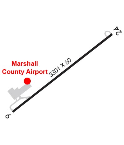
| Lat: N 3952.9 Long: W 08044.1 Elev: 1215 Var: +08 Longest Runway: 3301 | ||
| AWOS: 119.05 CTAF: 122.7 | ||
| |||||||||||||||||||||||||||||||||||||||||||||||||||||||||||||
| |||||||||||||||||||||||||||||||||||||||||||||||||||||||||||||
| |||||||||||||||||||||||||||||||||||||||||||||||||||||||||||||
| Rwy | Rwy | |||||||
| 3301x60 | 3301' | 3301x60 | 3301' | |||||
| Runway ID | Single Wheel | Double Wheel | Double Tandem Wheel | Dual Double Wheel |
| 06/24 | 12,500 | N/A | N/A | N/A |
| These numbers are Advisory and are not limits. The Airport Manager should have more accurate Weight Limits | ||||
 Airport Diagram might not be current. | |
| Facility Name: | MARSHALL COUNTY |
| City Name: | MOUNDSVILLE |
| County: | MARSHALL |
| State abbrev: | WV |
| State Name: | WEST VIRGINIA |
| Ownership: | PUBLICLY OWNED |
| Use: | OPEN TO THE PUBLIC |
| Owner's Name: | MARSHALL CO COMSN |
| Address: | COUNTY COURT HOUSE |
| MOUNDSVILLE, WV 26041 | |
| Owner's Phone: | 304-845-0482 |
| Manager's Name: | SUSAN BOARD |
| Address: | 901 KULL LN |
| MOUNDSVILLE, WV 26041 | |
| Phone: | 304-845-0200 |
| FAA Region: | EASTERN |
| FAA Field Office: | BKW |
| Date | Sunrise | Sunset |
|---|---|---|
| 09/24/21 Friday | 7:12 | 19:17 |
| 09/25/21 Saturday | 7:13 | 19:15 |
| 09/26/21 Sunday | 7:14 | 19:14 |
| 09/27/21 Monday | 7:15 | 19:12 |
| 09/28/21 Tuesday | 7:16 | 19:11 |
| 09/29/21 Wednesday | 7:17 | 19:09 |
| 09/30/21 Thursday | 7:18 | 19:07 |
| 10/01/21 Friday | 7:19 | 19:06 |
| 10/02/21 Saturday | 7:20 | 19:04 |
| 10/03/21 Sunday | 7:21 | 19:02 |
| 10/04/21 Monday | 7:22 | 19:01 |
| 10/05/21 Tuesday | 7:23 | 18:59 |
| 10/06/21 Wednesday | 7:24 | 18:58 |
| 10/07/21 Thursday | 7:25 | 18:56 |
| Airport Attendance Schedule | 7 Days A Week 0830-DUSK; FOR ATTENDANT AFTER HRS CALL 304-312-1199 (MGR CELL). |
| Airport Status | OPERATIONAL (This Status can change at any time - please check NOTAMS) |
| Airport Lighting Schedule | ACTVT MIRL RWY 06/24 - CTAF. PAPI RWYS 06 & 24 OPER CONT.; ACTVT RTG BCN - CTAF. |
| Airport Storage Available | Tie Downs, Hanger |
| Extra Services Available | NONE |
| Wind Indicator | YES - (lighted) |
| Control Tower | NO |
| CTAF Frequency | 122.700 |
| Unicom Frequency | 122.700 |
| Rotating Beacon Color | CLEAR-GREEN (Light Land Airport) |
| Segmented Circle | YES |
| Landing Fee | NO |
| Airport Inspected | STATE - performed by PRIVATE CONTRACT PERSONNEL |
| Inspection Date | 08/07/2019 |
| Type of Fuel Available | Grade 100LL |
| Airframe Repair Service | MAJOR |
| Power Plant Repair Service | MAJOR |
| Latitude | N3952.9 |
| Longitude | W08044.1 (ESTIMATED) |
| Arpt Elevation | 1214ft (SURVEYED) |
| Magnetic Variation | 08W |
| 3 miles S | of MOUNDSVILLE |
| Traffic Pattern Altitude | |
| Sectional Chart | CINCINNATI |
| Operations (Reported) | Yearly | Avg. Daily |
|---|---|---|
| General Aviation Transient | 5000 | 14 |
| General Aviation Local | 5000 | 14 |
| Air Taxi | 50 | 0 |
| Commerical | 0 | 0 |
| Commuter | 0 | 0 |
| Military | 50 | 0 |
| Aircraft based on Field | |
|---|---|
| General Aviation Singles | 13 |
| General Aviation Multi | 1 |
| Jet Aircraft | 0 |
| General Aviation Helicopters | 2 |
| Military Aircraft | 0 |
| Gliders | 0 |
| Ultralights | 0 |
| FSS on field | NO |
| FSS tie-in | ELKINS |
| FSS Phone | 1-800-WX-BRIEF |
| Who issues Notams | EKN |
| Notam D service at airport | YES |
| ARTCC Name | CLEVELAND |
| Airport Certification | |
| Aircraft Rescue & Firefighting Index | None |
| Airport of Entry | No |
| Custom Landing Rights | No |
| Joint Civil/Military | No |
| Military Landing rights | YES |
| NATIONAL PLAN OF INTEGRATED AIRPORT SYSTEMS (NPIAS) |
| GRANT AGREEMENTS UNDER FAAP/ADAP/AIP |
| ASSURANCES PURSUANT TO TITLE VI, CIVIL RIGHTS ACT OF 1964 |
| DEER & BIRDS ON & INVOF ARPT. |
| RWY 24 HAS .6% UPHILL GRADIENT. |
| RWY SAFETY AREA BOTH ENDS HAVE 100 FT DROPOFFS 200 FT FM THR 0B. |
| RWY 24, DUE TO TERRAIN, WINDS MAY BE TURBULENT ON APCH. |
| FOR CD CTC CLEVELAND ARTCC AT 440-774-0226. |
Airport Communications & Frequencies:
| |||||||||
| Runway: 06 | Runway: 24 | ||
| Mag heading: | 60° | Mag heading: | 240° |
| Rwy Slope: | -.60% Down | Rwy Slope: | .60% Up |
| Approach: | Approach: | ||
| Pattern: | Left Traffic | Pattern: | Left Traffic |
| Markings: | NONPRECISION INSTRUMENT | Markings: | NONPRECISION INSTRUMENT |
| Marking Condition: | POOR; RWY MARKINGS FADED, NOT VISIBLE FROM THE AIR. | Marking Condition: | RWY MARKINGS FADED, NOT VISIBLE FROM THE AIR. |
| Arresting Dev: | Arresting Dev: | ||
| Lat & Long: | N3952.7 W08044.4 | Lat. & Long.: | N3953.0 W08043.9 |
| Elev: | 1214.4 ft. MSL | Elev: | 1194.6 ft. MSL |
| TCH: | 30 ft. AGL | TCH: | 46 ft. AGL |
| Visual Glide Path: | 4.00 degrees | Visual Glide Path: | 3.00 degrees |
| Displaced Threshold: | No | Displaced Threshold: | No |
| Touchdown Zone: | YES | Touchdown Zone: | YES |
| Touchdown Elev.: | 1214.6 feet | Touchdown Elev.: | 1213.3 feet |
| Visual Glide Slope: | 2-Light PAPI on LEFT side of Runway | Visual Glide Slope: | 2-Light PAPI on RIGHT side of Runway; UNUSBL BYD 7 DEGS LEFT OF CNTRLN. |
| RVR Equipment: | RVR Equipment: | ||
| RVV Equipment: | NO | RVV Equipment: | NO |
| Approach Lights: | Approach Lights: | ||
| REIL: | NO | REIL: | NO |
| Centerline Lights: | NO | Centerline Lights: | NO |
| Touchdown lights: | NO | Touchdown lights: | NO |
| Runway Category: | Runway with a Non-precision Approach | Runway Category: | Runway with a Non-precision Approach |
| Declared Distances: | Declared Distances: | ||
| Obstructions: | PLINE | Obstructions: | PLINE |
| Marked: | NOT Marked/Lighted | Marked: | NOT Marked/Lighted |
| Clearance slope: | 25:1 | Clearance slope: | 34:1 |
| Obstruction height: | 213 feet AGL | Obstruction height: | 147 feet AGL |
| Dist. from runway: | 5525 feet | Dist. from runway: | 5200 feet |
| Centerline offset: | Centerline offset: | ||
| Comments: | Comments: | 10 FT BRUSH, 25-199 FT DSTC, 75-125 FT L. |
Thanks for using FltPlan.com
all rights reserved © 1999-2021 by Flight Plan LLC