
| MINOT INTL MINOT ND |
| |
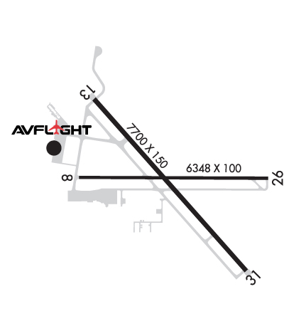
| Lat: N 4815.5 Long: W 10116.7 Elev: 1716 Var: -06 Longest Runway: 7700 | ||
| AWOS: 118.72 Ground: 121.9 Tower: 118.2 | ||
| ||||||||||||||||||||||||||||||||||||||||||||
| ||||||||||||||||||||||||||||||||||||||||||||
| ||||||||||||||||||||||||||||||||||||||||||||
| FBOs at nearby airports who want your business: | |||||||||||||||||
| |||||||||||||||||
| Rwy | Rwy | |||||||
| 6348x100 | 5955' | 6348x100 | 6348' | |||||
| 7700x150 | 7700' | 7700x150 | 7700' | 111.90 - 312° | ||||
| Runway ID | Single Wheel | Double Wheel | Double Tandem Wheel | Dual Double Wheel |
| 08/26 | 81,000 | 118,000 | 186,000 | N/A |
| 13/31 | 120,000 | 162,000 | 262,000 | N/A |
| These numbers are Advisory and are not limits. The Airport Manager should have more accurate Weight Limits | ||||
 Airport Diagram might not be current. | |
| Facility Name: | MINOT INTL |
| City Name: | MINOT |
| County: | WARD |
| State abbrev: | ND |
| State Name: | NORTH DAKOTA |
| Ownership: | PUBLICLY OWNED |
| Use: | OPEN TO THE PUBLIC |
| Owner's Name: | CITY OF MINOT |
| Address: | 305 AIRPORT RD., SUITE 216 |
| MINOT, ND 58703 | |
| Owner's Phone: | 701-857-4724 |
| Manager's Name: | JENNIFER ECKMAN |
| Address: | 305 AIRPORT RD, SUITE 216 |
| MINOT, ND 58703 | |
| Phone: | 701-857-4724 |
| FAA Region: | GREAT LAKES |
| FAA Field Office: | DMA |
| Date | Sunrise | Sunset |
|---|---|---|
| 06/12/26 Friday | 5:44 | 21:46 |
| 06/13/26 Saturday | 5:44 | 21:47 |
| 06/14/26 Sunday | 5:44 | 21:47 |
| 06/15/26 Monday | 5:44 | 21:48 |
| 06/16/26 Tuesday | 5:44 | 21:48 |
| 06/17/26 Wednesday | 5:44 | 21:48 |
| 06/18/26 Thursday | 5:44 | 21:49 |
| 06/19/26 Friday | 5:44 | 21:49 |
| 06/20/26 Saturday | 5:44 | 21:49 |
| 06/21/26 Sunday | 5:44 | 21:49 |
| 06/22/26 Monday | 5:44 | 21:50 |
| 06/23/26 Tuesday | 5:45 | 21:50 |
| 06/24/26 Wednesday | 5:45 | 21:50 |
| 06/25/26 Thursday | 5:45 | 21:50 |
| Airport Attendance Schedule | CONTINUOUS |
| Airport Status | OPERATIONAL (This Status can change at any time - please check NOTAMS) |
| Airport Lighting Schedule | WHEN ATCT IS CLSD, ACTVT MALSR RWY 31; REIL RWYS 08 & 26; HIRL RWYS 08/26 & 13/31 - CTAF. PAPI RWYS 08, 13, & 26 OPR CONSLY. |
| Airport Storage Available | Tie Downs |
| Extra Services Available | Crop Dusting, Air Ambulance, Avionics, Charter, Flight Instruction, Aircraft Rental, Aircraft Sales |
| Wind Indicator | YES - (lighted) |
| Control Tower | YES |
| CTAF Frequency | 118.200 |
| Unicom Frequency | 122.950 |
| Rotating Beacon Color | WG |
| Segmented Circle | YES |
| Landing Fee | YES; LDG FEE FOR ALL COML FREIGHT AND COMMUTER ACFT AND ALL ACFT OVR 12500 LB. |
| Airport Inspected | FEDERAL - performed by FAA AIRPORTS FIELD PERSONNEL |
| Inspection Date | 06/04/2025 |
| Type of Fuel Available | Grade 100LL, JET A (freeze point -40C) |
| Airframe Repair Service | MAJOR |
| Power Plant Repair Service | MAJOR |
| Latitude | N4815.5 |
| Longitude | W10116.7 (ESTIMATED) |
| Arpt Elevation | 1715ft (SURVEYED) |
| Magnetic Variation | 06E |
| 2 miles N | of MINOT |
| Traffic Pattern Altitude | |
| Sectional Chart | BILLINGS |
| Operations (Reported) | Yearly | Avg. Daily |
|---|---|---|
| General Aviation Transient | 0 | 0 |
| General Aviation Local | 0 | 0 |
| Air Taxi | 0 | 0 |
| Commerical | 0 | 0 |
| Commuter | 0 | 0 |
| Military | 0 | 0 |
| Aircraft based on Field | |
|---|---|
| General Aviation Singles | 0 |
| General Aviation Multi | 0 |
| Jet Aircraft | 0 |
| General Aviation Helicopters | 0 |
| Military Aircraft | 0 |
| Gliders | 0 |
| Ultralights | 0 |
| FSS on field | NO |
| FSS tie-in | GRAND FORKS |
| FSS Phone | 1-800-WX-BRIEF |
| Who issues Notams | MOT |
| Notam D service at airport | YES |
| ARTCC Name | MINNEAPOLIS |
| Airport Certification | AIRPORT RECEIVING SCHEDULED AIR CARRIER SERVICE FROM CARRIERS CERTIFICATED BY THE CIVIL AERONAUTICS BOARD |
| Aircraft Rescue & Firefighting Index | AIRPORT HAS A CERTIFICATE UNDER CFR PART 139 |
| Airport of Entry | YES |
| Custom Landing Rights | No |
| Joint Civil/Military | No |
| Military Landing rights | YES |
| NATIONAL PLAN OF INTEGRATED AIRPORT SYSTEMS (NPIAS) |
| GRANT AGREEMENTS UNDER FAAP/ADAP/AIP |
| ASSURANCES PURSUANT TO TITLE VI, CIVIL RIGHTS ACT OF 1964 |
| AGREEMENT UNDER DLAND OR DCLA HAS EXPIRED. |
| DEER & BIRDS INVOF ARPT. |
| AIRFIELD STD TFC PATTERN ALT 1000 FT; OVERFLY ALT 1500 FT. |
| WHEN ATCT CLSD CTC - CTAF. |
| TWYS E, B2, F, AND A ARE MKD WITH EDGE REFLECTORS. |
| CUSTOMS SVC AVBL 24 HRS; FOR CUSTOMS CALL 701-838-6704. |
| MINOT AFB (MIB) ASR OTS FOR PREVENTIVE MAINTENANCE FRIDAYS 0700-0900 & ALTN TUESDAYS 0630-0830. |
| RDO EQUIPD ACFT MUST ANNC ON CTAF - 118.2 WHEN TWR IS CLSD. |
| FOR CD IF UNA TO CTC ON FSS FREQ, CTC MINNEAPOLIS ARTCC AT 651-463-5588. |
| RWY 08/2 6 PCR VALUE: 320/F/C/X/T |
| RWY 13/3 1 PCR VALUE: 500/R/C/W/T |
Airport Communications & Frequencies:
| |||||||||||||||||||||||
| Runway: 08 | Runway: 26 | ||
| Mag heading: | 84° | Mag heading: | 264° |
| Rwy Slope: | -.91% Down | Rwy Slope: | .91% Up |
| Approach: | Approach: | ||
| Pattern: | Left Traffic | Pattern: | Left Traffic |
| Markings: | NONPRECISION INSTRUMENT | Markings: | NONPRECISION INSTRUMENT |
| Marking Condition: | GOOD | Marking Condition: | GOOD |
| Arresting Dev: | Arresting Dev: | ||
| Lat & Long: | N4815.5 W10117.4 | Lat. & Long.: | N4815.5 W10115.9 |
| Elev: | 1715.7 ft. MSL | Elev: | 1658.2 ft. MSL |
| TCH: | 45 ft. AGL | TCH: | 49 ft. AGL |
| Visual Glide Path: | 3.00 degrees | Visual Glide Path: | 3.00 degrees |
| Displaced Threshold: | 393 feet | Displaced Threshold: | No |
| Touchdown Zone: | YES | Touchdown Zone: | YES |
| Touchdown Elev.: | 1711.8 feet | Touchdown Elev.: | 1681.8 feet |
| Visual Glide Slope: | 4-Light PAPI on LEFT side of Runway | Visual Glide Slope: | 4-Light PAPI on LEFT side of Runway |
| RVR Equipment: | RVR Equipment: | ||
| RVV Equipment: | NO | RVV Equipment: | NO |
| Approach Lights: | Approach Lights: | ||
| REIL: | YES | REIL: | YES |
| Centerline Lights: | NO | Centerline Lights: | NO |
| Touchdown lights: | NO | Touchdown lights: | NO |
| Runway Category: | Runway with a Non-precision Approach having visibility minimums greater than 3/4 mile | Runway Category: | Runway with a Non-precision Approach having visibility minimums greater than 3/4 mile |
| Declared Distances: | TORA:6348' TODA:6348' ASDA:6348' LDA:5958' | Declared Distances: | TORA:5958' TODA:5958' ASDA:6348' LDA:6348' |
| Obstructions: | TREES | Obstructions: | |
| Marked: | NOT Marked/Lighted | Marked: | |
| Clearance slope: | 27:1; RWY 08 APCH RATIO 32:1 FM DSPLCD THLD. | Clearance slope: | 50:1 |
| Obstruction height: | 57 feet AGL | Obstruction height: | |
| Dist. from runway: | 1790 feet | Dist. from runway: | |
| Centerline offset: | 460 left of centerline | Centerline offset: | |
| Comments: | Comments: |
| Runway: 13 | Runway: 31 | ||
| Mag heading: | 132° | Mag heading: | 312° |
| Rwy Slope: | -.58% Down | Rwy Slope: | .58% Up |
| Approach: | Approach: | ILS/DME | |
| Pattern: | Left Traffic | Pattern: | Left Traffic |
| Markings: | PRECISION INSTRUMENT | Markings: | PRECISION INSTRUMENT |
| Marking Condition: | GOOD | Marking Condition: | GOOD |
| Arresting Dev: | Arresting Dev: | ||
| Lat & Long: | N4815.9 W10117.3 | Lat. & Long.: | N4815.0 W10116.1 |
| Elev: | 1701.8 ft. MSL | Elev: | 1657.1 ft. MSL |
| TCH: | 49 ft. AGL | TCH: | |
| Visual Glide Path: | 3.00 degrees | Visual Glide Path: | |
| Displaced Threshold: | No | Displaced Threshold: | No |
| Touchdown Zone: | YES | Touchdown Zone: | YES |
| Touchdown Elev.: | 1701.8 feet | Touchdown Elev.: | 1679.1 feet |
| Visual Glide Slope: | 4-Light PAPI on LEFT side of Runway | Visual Glide Slope: | |
| RVR Equipment: | ROLLOUT | RVR Equipment: | TOUCHDOWN |
| RVV Equipment: | NO | RVV Equipment: | NO |
| Approach Lights: | Approach Lights: | MALSR - 1,400 foot medium intensity approach lighting system with runway alignment indicator lights | |
| REIL: | YES | REIL: | NO |
| Centerline Lights: | NO | Centerline Lights: | NO |
| Touchdown lights: | NO | Touchdown lights: | NO |
| Runway Category: | Runway with a Non-precision Approach having visibility minimums greater than 3/4 mile | Runway Category: | Precision Instrument Runway |
| Declared Distances: | TORA:7700' TODA:7700' ASDA:7700' LDA:7700' | Declared Distances: | TORA:7700' TODA:7700' ASDA:7700' LDA:7700' |
Thanks for using FltPlan.com
all rights reserved © 1999-2026 by Flight Plan LLC