
| MOORE-MURRELL MORRISTOWN TN |
| |
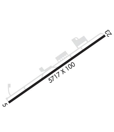
| Lat: N 3610.8 Long: W 08322.5 Elev: 1313 Var: +04 Longest Runway: 5718 | ||
| AWOS: 126.72 CTAF: 122.8 | ||
| ||||||||||||||||||||||||||||||||||||||||||||
| ||||||||||||||||||||||||||||||||||||||||||||
| ||||||||||||||||||||||||||||||||||||||||||||
| Rwy | Rwy | |||||||
| 5718x100 | 5718' | 109.50 - 053° | 5718x100 | 5718' | ||||
| Runway ID | Single Wheel | Double Wheel | Double Tandem Wheel | Dual Double Wheel |
| 05/23 | 30,000 | 60,000 | N/A | N/A |
| These numbers are Advisory and are not limits. The Airport Manager should have more accurate Weight Limits | ||||
 Airport Diagram might not be current. | |
| Facility Name: | MOORE-MURRELL |
| City Name: | MORRISTOWN |
| County: | HAMBLEN |
| State abbrev: | TN |
| State Name: | TENNESSEE |
| Ownership: | PUBLICLY OWNED |
| Use: | OPEN TO THE PUBLIC |
| Owner's Name: | CITY OF MORRISTOWN |
| Address: | CITY HALL PO BOX 1499 |
| MORRISTOWN, TN 37816 | |
| Owner's Phone: | 423-581-0100 |
| Manager's Name: | ANDREW ELLARD |
| Address: | 100 WEST FIRST NORTH STREET |
| MORRISTOWN, TN 37816 | |
| Phone: | 423-585-4614 |
| FAA Region: | SOUTHERN |
| FAA Field Office: | MEM |
| Date | Sunrise | Sunset |
|---|---|---|
| 06/08/26 Monday | 6:16 | 20:49 |
| 06/09/26 Tuesday | 6:16 | 20:50 |
| 06/10/26 Wednesday | 6:16 | 20:50 |
| 06/11/26 Thursday | 6:16 | 20:51 |
| 06/12/26 Friday | 6:16 | 20:51 |
| 06/13/26 Saturday | 6:16 | 20:52 |
| 06/14/26 Sunday | 6:16 | 20:52 |
| 06/15/26 Monday | 6:16 | 20:52 |
| 06/16/26 Tuesday | 6:16 | 20:53 |
| 06/17/26 Wednesday | 6:16 | 20:53 |
| 06/18/26 Thursday | 6:16 | 20:53 |
| 06/19/26 Friday | 6:16 | 20:54 |
| 06/20/26 Saturday | 6:16 | 20:54 |
| 06/21/26 Sunday | 6:16 | 20:54 |
| Airport Attendance Schedule | 7 Days A Week 0800-DUSK |
| Airport Status | OPERATIONAL (This Status can change at any time - please check NOTAMS) |
| Airport Lighting Schedule | DAYTIME, ACTVT REIL RWY 5 & 23; PAPI RWY 5 & 23; MIRL 5/23 - CTAF. DUSK-DAWN, REIL RWY 5 & 23; PAPI RWY 5 & 23; MIRL 5/23 - OPR CONSLY. |
| Airport Storage Available | Tie Downs |
| Extra Services Available | Air Freight, Charter, Flight Instruction, Aircraft Rental |
| Wind Indicator | YES - (lighted) |
| Control Tower | NO |
| CTAF Frequency | 122.800 |
| Unicom Frequency | 122.800 |
| Rotating Beacon Color | WG |
| Segmented Circle | YES |
| Landing Fee | NO |
| Airport Inspected | STATE - performed by STATE AERONAUTICAL PERSONNEL |
| Inspection Date | 06/11/2024 |
| Type of Fuel Available | Grade 100LL, JET A (freeze point -40C) |
| Airframe Repair Service | MAJOR |
| Power Plant Repair Service | MAJOR |
| Latitude | N3610.8 |
| Longitude | W08322.5 (ESTIMATED) |
| Arpt Elevation | 1312ft (SURVEYED) |
| Magnetic Variation | 04W |
| 4 miles SW | of MORRISTOWN |
| Traffic Pattern Altitude | |
| Sectional Chart | CINCINNATI |
| Operations (Reported) | Yearly | Avg. Daily |
|---|---|---|
| General Aviation Transient | 0 | 0 |
| General Aviation Local | 0 | 0 |
| Air Taxi | 0 | 0 |
| Commerical | 0 | 0 |
| Commuter | 0 | 0 |
| Military | 0 | 0 |
| Aircraft based on Field | |
|---|---|
| General Aviation Singles | 0 |
| General Aviation Multi | 0 |
| Jet Aircraft | 0 |
| General Aviation Helicopters | 0 |
| Military Aircraft | 0 |
| Gliders | 0 |
| Ultralights | 0 |
| FSS on field | NO |
| FSS tie-in | NASHVILLE |
| FSS Phone | 1-800-WX-BRIEF |
| Who issues Notams | BNA |
| Notam D service at airport | YES |
| ARTCC Name | ATLANTA |
| Airport Certification | |
| Aircraft Rescue & Firefighting Index | None |
| Airport of Entry | No |
| Custom Landing Rights | No |
| Joint Civil/Military | No |
| Military Landing rights | YES |
| NATIONAL PLAN OF INTEGRATED AIRPORT SYSTEMS (NPIAS) |
| GRANT AGREEMENTS UNDER FAAP/ADAP/AIP |
| ASSURANCES PURSUANT TO TITLE VI, CIVIL RIGHTS ACT OF 1964 |
| DEER ON & INVOF ARPT. |
| FOR CD CTC KNOXVILLE APCH AT 865-980-3034; IF UNA FOR CD CTC KNOXVILLE APCH AT 865-980-3033. |
| (PAY PHONE) PAY PHONE AVAILABLE. |
Airport Communications & Frequencies:
| ||||||||||||||
| Runway: 05 | Runway: 23 | ||
| Mag heading: | 53° | Mag heading: | 233° |
| Rwy Slope: | -.67% Down | Rwy Slope: | .67% Up |
| Approach: | SDF/DME | Approach: | |
| Pattern: | Left Traffic | Pattern: | Left Traffic |
| Markings: | BASIC | Markings: | NONPRECISION INSTRUMENT |
| Marking Condition: | GOOD | Marking Condition: | GOOD |
| Arresting Dev: | Arresting Dev: | ||
| Lat & Long: | N3610.5 W08323.0 | Lat. & Long.: | N3611.1 W08322.1 |
| Elev: | 1312.8 ft. MSL | Elev: | 1274.3 ft. MSL |
| TCH: | 41 ft. AGL | TCH: | 42 ft. AGL |
| Visual Glide Path: | 3.00 degrees | Visual Glide Path: | 3.00 degrees |
| Displaced Threshold: | No | Displaced Threshold: | No |
| Touchdown Zone: | YES | Touchdown Zone: | YES |
| Touchdown Elev.: | 1312.8 feet | Touchdown Elev.: | 1292.3 feet |
| Visual Glide Slope: | 2-Light PAPI on LEFT side of Runway | Visual Glide Slope: | 2-Light PAPI on LEFT side of Runway |
| RVR Equipment: | RVR Equipment: | ||
| RVV Equipment: | NO | RVV Equipment: | NO |
| Approach Lights: | MALSF OTS INDEFLY. | Approach Lights: | |
| REIL: | YES | REIL: | YES |
| Centerline Lights: | NO | Centerline Lights: | NO |
| Touchdown lights: | NO | Touchdown lights: | NO |
| Runway Category: | D | Runway Category: | Runway with a Non-precision Approach having visibility minimums greater than 3/4 mile |
| Declared Distances: | Declared Distances: | ||
| Obstructions: | TREE | Obstructions: | TREE |
| Marked: | NOT Marked/Lighted | Marked: | NOT Marked/Lighted |
| Clearance slope: | 28:1 | Clearance slope: | 26:1 |
| Obstruction height: | 87 feet AGL | Obstruction height: | 61 feet AGL |
| Dist. from runway: | 2638 feet | Dist. from runway: | 1788 feet |
| Centerline offset: | 479 left of centerline | Centerline offset: | 263 feet right of centerline |
| Comments: | Comments: |
Thanks for using FltPlan.com
all rights reserved © 1999-2026 by Flight Plan LLC