
| MARION MUNI MARION OH |
| |
| Lat: N 4037.0 Long: W 08303.8 Elev: 993 Var: +05 Longest Runway: 5000 | ||
| Clr Del: 126.8 AWOS: 119.97 CTAF: 122.8 | ||
| ||||||
| ||||||
| ||||||
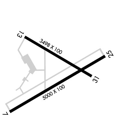
|
| Rwy | Rwy | |||||||
| 5000x100 | 5000' | 5000x100 | 5000' | 110.35 - 245° | ||||
| 3498x100 | 3498' | 3498x100 | 3498' | |||||
| Runway ID | Single Wheel | Double Wheel | Double Tandem Wheel | Dual Double Wheel |
| 07/25 | 70,000 | 95,000 | 150,000 | N/A |
| 13/31 | 56,000 | 68,000 | 105,000 | N/A |
| These numbers are Advisory and are not limits. The Airport Manager should have more accurate Weight Limits | ||||
 Airport Diagram might not be current. | |
| Facility Name: | MARION MUNI |
| City Name: | MARION |
| County: | MARION |
| State abbrev: | OH |
| State Name: | OHIO |
| Ownership: | PUBLICLY OWNED |
| Use: | OPEN TO THE PUBLIC |
| Owner's Name: | CITY OF MARION |
| Address: | CITY HALL, 233 W CENTER ST |
| MARION, OH 43302-3692 | |
| Owner's Phone: | 740-387-2020 |
| Manager's Name: | MATTHEW "MATT" ARNOLD |
| Address: | 1530 POLE LANE RD |
| MARION, OH 43302-8514 | |
| Phone: | 740-382-1634; ARPT OPS MGR 740-725-4146. ARPT DIR FOR EMERG ONLY 740-341-2233. |
| FAA Region: | GREAT LAKES |
| FAA Field Office: | DET |
| Date | Sunrise | Sunset |
|---|---|---|
| 09/24/21 Friday | 7:21 | 19:26 |
| 09/25/21 Saturday | 7:22 | 19:25 |
| 09/26/21 Sunday | 7:23 | 19:23 |
| 09/27/21 Monday | 7:24 | 19:21 |
| 09/28/21 Tuesday | 7:25 | 19:20 |
| 09/29/21 Wednesday | 7:26 | 19:18 |
| 09/30/21 Thursday | 7:27 | 19:16 |
| 10/01/21 Friday | 7:28 | 19:15 |
| 10/02/21 Saturday | 7:29 | 19:13 |
| 10/03/21 Sunday | 7:30 | 19:11 |
| 10/04/21 Monday | 7:32 | 19:10 |
| 10/05/21 Tuesday | 7:33 | 19:08 |
| 10/06/21 Wednesday | 7:34 | 19:07 |
| 10/07/21 Thursday | 7:35 | 19:05 |
| Airport Attendance Schedule | 7 Days A Week 0800-1700 |
| Airport Status | OPERATIONAL (This Status can change at any time - please check NOTAMS) |
| Airport Lighting Schedule | ACTVT REIL RWY 07, 25, 13, & 31; MIRL RWY 07/25 & 13/31 - CTAF. PAPI RWY 07, 25, 13, & 31 OPR CONSLY. |
| Airport Storage Available | Tie Downs, Hanger |
| Extra Services Available | Air Freight, Charter, Glider, Flight Instruction, Aircraft Rental, Aircraft Sales, Glider Towing |
| Wind Indicator | YES - (lighted) |
| Control Tower | NO |
| CTAF Frequency | 122.800 |
| Unicom Frequency | 122.800 |
| Rotating Beacon Color | CLEAR-GREEN (Light Land Airport) |
| Segmented Circle | NO |
| Landing Fee | NO |
| Airport Inspected | STATE - performed by PRIVATE CONTRACT PERSONNEL |
| Inspection Date | 10/14/2017 |
| Type of Fuel Available | Grade 100LL, JET A-1 (freeze point -50C), JET A-1 (icing inhibitor, freeze point -50C); -10100LL AVBL H24 SELF SER VIA CREDIT CARD. JET A AVBL AFT HRS BY PRIOR CDN. |
| Airframe Repair Service | MAJOR |
| Power Plant Repair Service | MAJOR |
| Latitude | N4037.0 |
| Longitude | W08303.8 (ESTIMATED) |
| Arpt Elevation | 993ft (SURVEYED) |
| Magnetic Variation | 05W |
| 3 miles NE | of MARION |
| Traffic Pattern Altitude | 800 |
| Sectional Chart | DETROIT |
| Operations (Reported) | Yearly | Avg. Daily |
|---|---|---|
| General Aviation Transient | 15000 | 41 |
| General Aviation Local | 20000 | 55 |
| Air Taxi | 4500 | 12 |
| Commerical | 0 | 0 |
| Commuter | 0 | 0 |
| Military | 150 | 0 |
| Aircraft based on Field | |
|---|---|
| General Aviation Singles | 19 |
| General Aviation Multi | 3 |
| Jet Aircraft | 0 |
| General Aviation Helicopters | 0 |
| Military Aircraft | 0 |
| Gliders | 27 |
| Ultralights | 0 |
| FSS on field | NO |
| FSS tie-in | CLEVELAND |
| FSS Phone | 1-800-WX-BRIEF |
| Who issues Notams | MNN |
| Notam D service at airport | YES |
| ARTCC Name | CLEVELAND |
| Airport Certification | |
| Aircraft Rescue & Firefighting Index | None |
| Airport of Entry | No |
| Custom Landing Rights | No |
| Joint Civil/Military | No |
| Military Landing rights | YES |
| NATIONAL PLAN OF INTEGRATED AIRPORT SYSTEMS (NPIAS) |
| GRANT AGREEMENTS UNDER FAAP/ADAP/AIP |
| ASSURANCES PURSUANT TO TITLE VI, CIVIL RIGHTS ACT OF 1964 |
| GLIDER ACT ON & INVOF ARPT, ANNC INTNS - CTAF. |
| TSNT ACFT FOLLOW RAMP SIGNS TO MAIN RAMP. TWY D BTN RWY & RAMP AREA RSTRD TO ACFT WITH WINGSPAN 35 FT OR LESS. |
| FOR CD CTC CLEVELAND APCH AT 216-352-2323, WHEN APCH CLSD CTC CLEVELAND ARTCC AT 440-774-0222. |
| DEER, BIRDS, & OTR WILDLIFE ON & INVOF ARPT. |
Airport Communications & Frequencies:
| |||||||||||||||||||
| Runway: 07 | Runway: 25 | ||
| Mag heading: | 65° | Mag heading: | 245° |
| Rwy Slope: | .08% Up | Rwy Slope: | -.08% Down |
| Approach: | Approach: | LOC/DME | |
| Pattern: | Left Traffic; GLIDERS & TOWPLANES USE RIGHT TFC. | Pattern: | Left Traffic |
| Markings: | NONPRECISION INSTRUMENT | Markings: | NONPRECISION INSTRUMENT |
| Marking Condition: | GOOD | Marking Condition: | GOOD |
| Arresting Dev: | Arresting Dev: | ||
| Lat & Long: | N4036.7 W08304.3 | Lat. & Long.: | N4037.1 W08303.3 |
| Elev: | 989.4 ft. MSL | Elev: | 993.4 ft. MSL |
| TCH: | 24 ft. AGL | TCH: | 31 ft. AGL |
| Visual Glide Path: | 3.00 degrees | Visual Glide Path: | 3.00 degrees |
| Displaced Threshold: | No | Displaced Threshold: | No |
| Touchdown Zone: | YES | Touchdown Zone: | YES |
| Touchdown Elev.: | 990.1 feet | Touchdown Elev.: | 993.4 feet |
| Visual Glide Slope: | 4-Light PAPI on LEFT side of Runway | Visual Glide Slope: | 4-Light PAPI on LEFT side of Runway |
| RVR Equipment: | RVR Equipment: | ||
| RVV Equipment: | NO | RVV Equipment: | NO |
| Approach Lights: | Approach Lights: | ||
| REIL: | YES | REIL: | YES |
| Centerline Lights: | NO | Centerline Lights: | NO |
| Touchdown lights: | NO | Touchdown lights: | NO |
| Runway Category: | Runway with a Non-precision Approach | Runway Category: | Runway with a Non-precision Approach |
| Declared Distances: | Declared Distances: | ||
| Obstructions: | ROAD | Obstructions: | TREES |
| Marked: | NOT Marked/Lighted | Marked: | NOT Marked/Lighted |
| Clearance slope: | 18:1 | Clearance slope: | 33:1 |
| Obstruction height: | 15 feet AGL | Obstruction height: | 85 feet AGL |
| Dist. from runway: | 475 feet | Dist. from runway: | 3050 feet |
| Centerline offset: | 280 left of centerline | Centerline offset: | 155 feet right of centerline |
| Comments: | Comments: |
| Runway: 13 | Runway: 31 | ||
| Mag heading: | 125° | Mag heading: | 305° |
| Rwy Slope: | .09% Up | Rwy Slope: | -.09% Down |
| Approach: | Approach: | ||
| Pattern: | Left Traffic | Pattern: | Left Traffic; GLIDERS & TOWPLANES USE RIGHT TFC. |
| Markings: | NONPRECISION INSTRUMENT | Markings: | NONPRECISION INSTRUMENT |
| Marking Condition: | GOOD | Marking Condition: | GOOD |
| Arresting Dev: | Arresting Dev: | ||
| Lat & Long: | N4037.2 W08304.1 | Lat. & Long.: | N4037.0 W08303.5 |
| Elev: | 986.2 ft. MSL | Elev: | 989.4 ft. MSL |
| TCH: | 21 ft. AGL | TCH: | 21 ft. AGL |
| Visual Glide Path: | 3.00 degrees | Visual Glide Path: | 3.00 degrees |
| Displaced Threshold: | No | Displaced Threshold: | No |
| Touchdown Zone: | YES | Touchdown Zone: | YES |
| Touchdown Elev.: | 990.6 feet | Touchdown Elev.: | 990.6 feet |
| Visual Glide Slope: | 2-Light PAPI on RIGHT side of Runway | Visual Glide Slope: | 2-Light PAPI on LEFT side of Runway |
| RVR Equipment: | RVR Equipment: | ||
| RVV Equipment: | NO | RVV Equipment: | NO |
| Approach Lights: | Approach Lights: | ||
| REIL: | YES | REIL: | YES |
| Centerline Lights: | NO | Centerline Lights: | NO |
| Touchdown lights: | NO | Touchdown lights: | NO |
| Runway Category: | Runway with a Non-precision Approach | Runway Category: | Runway with a Visual Approach |
| Declared Distances: | Declared Distances: | ||
| Obstructions: | TREES | Obstructions: | PLINE |
| Marked: | NOT Marked/Lighted | Marked: | NOT Marked/Lighted |
| Clearance slope: | 17:1 | Clearance slope: | 35:1 |
| Obstruction height: | 65 feet AGL | Obstruction height: | 47 feet AGL |
| Dist. from runway: | 1345 feet | Dist. from runway: | 1875 feet |
| Centerline offset: | 235 right of centerline | Centerline offset: | 275 feet right of centerline |
| Comments: | Comments: |
Thanks for using FltPlan.com
all rights reserved © 1999-2021 by Flight Plan LLC
