
| MENOMINEE-MARINETTE TWIN CNTY MENOMINEE MI |
| |
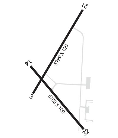
| Lat: N 4507.6 Long: W 08738.3 Elev: 625 Var: +03 Longest Runway: 5999 | ||
| AWOS: 109.6 CTAF: 122.8 | ||
| ||||||||||||||||||||||||||||||||||||||||||||
| ||||||||||||||||||||||||||||||||||||||||||||
| ||||||||||||||||||||||||||||||||||||||||||||
| Rwy | Rwy | |||||||
| 5999x100 | 5999' | 108.70 - 033° | 5999x100 | 5999' | ||||
| 5101x100 | 5101' | 5101x100 | 5101' | |||||
| Runway ID | Single Wheel | Double Wheel | Double Tandem Wheel | Dual Double Wheel |
| 03/21 | 80,000 | 100,000 | 175,000 | N/A |
| 14/32 | 30,000 | 35,000 | 60,000 | N/A |
| These numbers are Advisory and are not limits. The Airport Manager should have more accurate Weight Limits | ||||
 Airport Diagram might not be current. | |
| Facility Name: | MENOMINEE RGNL |
| City Name: | MENOMINEE |
| County: | MENOMINEE |
| State abbrev: | MI |
| State Name: | MICHIGAN |
| Ownership: | PUBLICLY OWNED |
| Use: | OPEN TO THE PUBLIC |
| Owner's Name: | MENOMINEE COUNTY |
| Address: | 2801 N 22ND ST |
| MENOMINEE, MI 49858 | |
| Owner's Phone: | 906-863-8408 |
| Manager's Name: | JEFF LAFLEUR |
| Address: | 2801 NORTH 22ND ST |
| MENOMINEE, MI 49858-3401 | |
| Phone: | 906-863-8408 |
| FAA Region: | GREAT LAKES |
| FAA Field Office: | DET |
| Date | Sunrise | Sunset |
|---|---|---|
| 09/24/21 Friday | 6:40 | 18:45 |
| 09/25/21 Saturday | 6:41 | 18:43 |
| 09/26/21 Sunday | 6:42 | 18:41 |
| 09/27/21 Monday | 6:43 | 18:39 |
| 09/28/21 Tuesday | 6:45 | 18:37 |
| 09/29/21 Wednesday | 6:46 | 18:35 |
| 09/30/21 Thursday | 6:47 | 18:33 |
| 10/01/21 Friday | 6:48 | 18:31 |
| 10/02/21 Saturday | 6:50 | 18:29 |
| 10/03/21 Sunday | 6:51 | 18:28 |
| 10/04/21 Monday | 6:52 | 18:26 |
| 10/05/21 Tuesday | 6:53 | 18:24 |
| 10/06/21 Wednesday | 6:55 | 18:22 |
| 10/07/21 Thursday | 6:56 | 18:20 |
| Airport Attendance Schedule | MON-FRI 0800-1700; FOR SER AFT HRS CALL 715-938-2006 OR 906-282-0260. |
| Airport Status | OPERATIONAL (This Status can change at any time - please check NOTAMS) |
| Airport Lighting Schedule | ACTVT MALSR RWY 03; PAPI RWY 21 & 32; VASI RWY 14; HIRL RWY 03/21; MIRL RWY 14/32 - CTAF. |
| Airport Storage Available | Hanger |
| Extra Services Available | Charter |
| Wind Indicator | YES - (lighted) |
| Control Tower | NO |
| CTAF Frequency | 122.800 |
| Unicom Frequency | 122.800 |
| Rotating Beacon Color | CLEAR-GREEN (Light Land Airport) |
| Segmented Circle | NO |
| Landing Fee | NO |
| Airport Inspected | FEDERAL - performed by STATE AERONAUTICAL PERSONNEL |
| Inspection Date | 06/22/2018 |
| Type of Fuel Available | Grade 100LL, JET A (freeze point -40C); -10100LL AVBL H24 SELF SER VIA CREDIT CARD. |
| Airframe Repair Service | MINOR |
| Power Plant Repair Service | MINOR |
| Latitude | N4507.6 |
| Longitude | W08738.3 (ESTIMATED) |
| Arpt Elevation | 624ft (SURVEYED) |
| Magnetic Variation | 03W |
| 1 miles NW | of MENOMINEE |
| Traffic Pattern Altitude | |
| Sectional Chart | GREEN BAY |
| Operations (Reported) | Yearly | Avg. Daily |
|---|---|---|
| General Aviation Transient | 3614 | 10 |
| General Aviation Local | 3614 | 10 |
| Air Taxi | 650 | 2 |
| Commerical | 0 | 0 |
| Commuter | 0 | 0 |
| Military | 0 | 0 |
| Aircraft based on Field | |
|---|---|
| General Aviation Singles | 31 |
| General Aviation Multi | 3 |
| Jet Aircraft | 0 |
| General Aviation Helicopters | 6 |
| Military Aircraft | 0 |
| Gliders | 0 |
| Ultralights | 0 |
| FSS on field | NO |
| FSS tie-in | GREEN BAY |
| FSS Phone | 1-800-WX-BRIEF |
| Who issues Notams | MNM |
| Notam D service at airport | YES |
| ARTCC Name | MINNEAPOLIS |
| Airport Certification | |
| Aircraft Rescue & Firefighting Index | None |
| Airport of Entry | No |
| Custom Landing Rights | No |
| Joint Civil/Military | No |
| Military Landing rights | YES |
| NATIONAL PLAN OF INTEGRATED AIRPORT SYSTEMS (NPIAS) |
| GRANT AGREEMENTS UNDER FAAP/ADAP/AIP |
| ASSURANCES PURSUANT TO TITLE VI, CIVIL RIGHTS ACT OF 1964 |
| AGREEMENT UNDER DLAND OR DCLA HAS EXPIRED. |
| DEER & GULLS ON & INVOF ARPT. |
| AVOID OVERFLIGHT OF NOISE SENSITIVE AREA LCTD 7 MI SOUTH. |
Airport Communications & Frequencies:
| |||||||||||||||||
| Runway: 03 | Runway: 21 | ||
| Mag heading: | 34° | Mag heading: | 214° |
| Rwy Slope: | .12% Up | Rwy Slope: | -.12% Down |
| Approach: | ILS | Approach: | |
| Pattern: | Left Traffic | Pattern: | Left Traffic |
| Markings: | PRECISION INSTRUMENT | Markings: | PRECISION INSTRUMENT |
| Marking Condition: | FAIR | Marking Condition: | FAIR |
| Arresting Dev: | Arresting Dev: | ||
| Lat & Long: | N4507.4 W08738.7 | Lat. & Long.: | N4508.2 W08737.9 |
| Elev: | 614.4 ft. MSL | Elev: | 621.8 ft. MSL |
| TCH: | TCH: | 42 ft. AGL | |
| Visual Glide Path: | Visual Glide Path: | 3.00 degrees | |
| Displaced Threshold: | No | Displaced Threshold: | No |
| Touchdown Zone: | YES | Touchdown Zone: | YES |
| Touchdown Elev.: | 624.0 feet | Touchdown Elev.: | 624.6 feet |
| Visual Glide Slope: | Visual Glide Slope: | 4-Light PAPI on LEFT side of Runway | |
| RVR Equipment: | RVR Equipment: | ||
| RVV Equipment: | NO | RVV Equipment: | NO |
| Approach Lights: | MALSR - 1,400 foot medium intensity approach lighting system with runway alignment indicator lights | Approach Lights: | |
| REIL: | NO | REIL: | NO |
| Centerline Lights: | NO | Centerline Lights: | NO |
| Touchdown lights: | NO | Touchdown lights: | NO |
| Runway Category: | Precision Instrument Runway | Runway Category: | Runway with a Non-precision Approach having visibility minimums greater than 3/4 mile |
| Declared Distances: | Declared Distances: | ||
| Obstructions: | Obstructions: | PLINE | |
| Marked: | Marked: | NOT Marked/Lighted | |
| Clearance slope: | 50:1 | Clearance slope: | 34:1 |
| Obstruction height: | Obstruction height: | 73 feet AGL | |
| Dist. from runway: | Dist. from runway: | 2770 feet | |
| Centerline offset: | Centerline offset: | 1250B | |
| Comments: | Comments: |
| Runway: 14 | Runway: 32 | ||
| Mag heading: | 143° | Mag heading: | 323° |
| Rwy Slope: | -.32% Down | Rwy Slope: | .32% Up |
| Approach: | Approach: | ||
| Pattern: | Left Traffic | Pattern: | Left Traffic |
| Markings: | NONPRECISION INSTRUMENT | Markings: | NONPRECISION INSTRUMENT |
| Marking Condition: | FAIR | Marking Condition: | FAIR |
| Arresting Dev: | Arresting Dev: | ||
| Lat & Long: | N4507.7 W08738.7 | Lat. & Long.: | N4507.0 W08737.9 |
| Elev: | 621.2 ft. MSL | Elev: | 605.1 ft. MSL |
| TCH: | 56 ft. AGL | TCH: | 52 ft. AGL |
| Visual Glide Path: | 4.00 degrees | Visual Glide Path: | 4.00 degrees |
| Displaced Threshold: | No | Displaced Threshold: | No |
| Touchdown Zone: | YES | Touchdown Zone: | YES |
| Touchdown Elev.: | 621.2 feet | Touchdown Elev.: | 608.3 feet |
| Visual Glide Slope: | 4-BOX VASI ON LEFT SIDE OF RUNWAY | Visual Glide Slope: | 4-Light PAPI on LEFT side of Runway |
| RVR Equipment: | RVR Equipment: | ||
| RVV Equipment: | NO | RVV Equipment: | NO |
| Approach Lights: | Approach Lights: | ||
| REIL: | NO | REIL: | NO |
| Centerline Lights: | NO | Centerline Lights: | NO |
| Touchdown lights: | NO | Touchdown lights: | NO |
| Runway Category: | Runway with a Visual Approach | Runway Category: | Runway with a Non-precision Approach having visibility minimums greater than 3/4 mile |
| Declared Distances: | Declared Distances: | ||
| Obstructions: | TREES | Obstructions: | TREE |
| Marked: | NOT Marked/Lighted | Marked: | NOT Marked/Lighted |
| Clearance slope: | 14:1 | Clearance slope: | 11:1 |
| Obstruction height: | 64 feet AGL | Obstruction height: | 59 feet AGL |
| Dist. from runway: | 1140 feet | Dist. from runway: | 851 feet |
| Centerline offset: | 185 left of centerline | Centerline offset: | 186 feet left of centerline |
| Comments: | Comments: |
Thanks for using FltPlan.com
all rights reserved © 1999-2021 by Flight Plan LLC
