
| MC MINNVILLE MUNI MC MINNVILLE OR |
| |
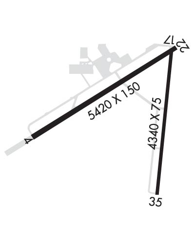
| Lat: N 4511.7 Long: W 12308.2 Elev: 163 Var: -19 Longest Runway: 5420 | ||
| Clr Del: 118.35 AWOS: 135.67 CTAF: 123.0 | ||
| ||||||||||||||||||||||||||||||||||||||||||||
| ||||||||||||||||||||||||||||||||||||||||||||
| ||||||||||||||||||||||||||||||||||||||||||||
| Rwy | Rwy | |||||||
| 5420x100 | 5420' | 5420x100 | 5420' | 110.90 - 218° | ||||
| 4340x75 | 4340' | 4340x75 | 4340' | |||||
| Runway ID | Single Wheel | Double Wheel | Double Tandem Wheel | Dual Double Wheel |
| 04/22 | 40,000 | 50,000 | 80,000 | N/A |
| 17/35 | 30,000 | N/A | N/A | N/A |
| These numbers are Advisory and are not limits. The Airport Manager should have more accurate Weight Limits | ||||
 Airport Diagram might not be current. | |
| Facility Name: | MC MINNVILLE MUNI |
| City Name: | MC MINNVILLE |
| County: | YAMHILL |
| State abbrev: | OR |
| State Name: | OREGON |
| Ownership: | PUBLICLY OWNED |
| Use: | OPEN TO THE PUBLIC |
| Owner's Name: | CITY OF MC MINNVILLE |
| Address: | CITY HALL- 230 NORTH EAST SECOND ST |
| MC MINNVILLE, OR 97128 | |
| Owner's Phone: | 503-434-7312 |
| Manager's Name: | ROY ARMSTRONG |
| Address: | 4000 SE CIRRUS AVE |
| MC MINNVILLE, OR 97128 | |
| Phone: | (503) 376-0190 |
| FAA Region: | NORTHWEST MOUNTAIN |
| FAA Field Office: | SEA |
| Date | Sunrise | Sunset |
|---|---|---|
| 09/24/21 Friday | 7:02 | 19:06 |
| 09/25/21 Saturday | 7:03 | 19:05 |
| 09/26/21 Sunday | 7:04 | 19:03 |
| 09/27/21 Monday | 7:05 | 19:01 |
| 09/28/21 Tuesday | 7:07 | 18:59 |
| 09/29/21 Wednesday | 7:08 | 18:57 |
| 09/30/21 Thursday | 7:09 | 18:55 |
| 10/01/21 Friday | 7:10 | 18:53 |
| 10/02/21 Saturday | 7:12 | 18:51 |
| 10/03/21 Sunday | 7:13 | 18:49 |
| 10/04/21 Monday | 7:14 | 18:48 |
| 10/05/21 Tuesday | 7:15 | 18:46 |
| 10/06/21 Wednesday | 7:17 | 18:44 |
| 10/07/21 Thursday | 7:18 | 18:42 |
| Airport Attendance Schedule | 7 Days A Week 1600-0100Z |
| Airport Status | OPERATIONAL (This Status can change at any time - please check NOTAMS) |
| Airport Lighting Schedule | ACTVT MALSR RWY 22; REIL RWY 04; PAPI RWY 22; HIRL RWY 04/22 - CTAF. PAPI RWY 22 OPR CONSLY; CTL INTST USING CTAF. |
| Airport Storage Available | Tie Downs |
| Extra Services Available | Glider, Flight Instruction, Aircraft Rental, Aircraft Sales, Glider Towing |
| Wind Indicator | YES - (lighted) |
| Control Tower | NO |
| CTAF Frequency | 123.000 |
| Unicom Frequency | 123.000; FBO MAY BE CONTACTED ON FREQ 123.00. |
| Rotating Beacon Color | CLEAR-GREEN (Light Land Airport) |
| Segmented Circle | YES |
| Landing Fee | NO |
| Airport Inspected | FEDERAL - performed by STATE AERONAUTICAL PERSONNEL |
| Inspection Date | 09/20/2018 |
| Type of Fuel Available | Grade 100LL, JET A (freeze point -40C); -10100LL FUEL 24 HR CREDIT CARD SVC AVBL. |
| Airframe Repair Service | MAJOR |
| Power Plant Repair Service | MAJOR |
| Latitude | N4511.7 |
| Longitude | W12308.2 (ESTIMATED) |
| Arpt Elevation | 162ft (SURVEYED) |
| Magnetic Variation | 19E |
| 3 miles SE | of MC MINNVILLE |
| Traffic Pattern Altitude | |
| Sectional Chart | SEATTLE |
| Operations (Reported) | Yearly | Avg. Daily |
|---|---|---|
| General Aviation Transient | 40000 | 110 |
| General Aviation Local | 22000 | 60 |
| Air Taxi | 0 | 0 |
| Commerical | 0 | 0 |
| Commuter | 0 | 0 |
| Military | 1500 | 4 |
| Aircraft based on Field | |
|---|---|
| General Aviation Singles | 94 |
| General Aviation Multi | 7 |
| Jet Aircraft | 3 |
| General Aviation Helicopters | 15 |
| Military Aircraft | 0 |
| Gliders | 4 |
| Ultralights | 0 |
| FSS on field | NO |
| FSS tie-in | MC MINNVILLE |
| FSS Phone | 1-800-WX-BRIEF |
| Who issues Notams | MMV |
| Notam D service at airport | YES |
| ARTCC Name | SEATTLE |
| Airport Certification | |
| Aircraft Rescue & Firefighting Index | None |
| Airport of Entry | No |
| Custom Landing Rights | No; US CUSTOMS USER FEE ARPT. |
| Joint Civil/Military | No |
| Military Landing rights | YES |
| NATIONAL PLAN OF INTEGRATED AIRPORT SYSTEMS (NPIAS) |
| GRANT AGREEMENTS UNDER FAAP/ADAP/AIP |
| ASSURANCES PURSUANT TO TITLE VI, CIVIL RIGHTS ACT OF 1964 |
| AGREEMENT UNDER DLAND OR DCLA HAS EXPIRED. |
| GLIDER OPNS RY 17/35 & WITHIN 8 NM BELOW 8000 FT DURING DALGT HRS FEB - NOV. |
| (A89) ADDNL PHONE NR. TO FSS LC434-5508. |
| TAXIWAYS "A" AND "D" HAVE BLUE EDGE REFLECTORS |
| AFTER HRS CALL OUT LIST POSTED ON DOOR |
| FOR CD CTC PORTLAND APCH AT 503-493-7545. |
Airport Communications & Frequencies:
| |||||||||||||||||||||||
| Runway: 04 | Runway: 22 | ||
| Mag heading: | 38° | Mag heading: | 218° |
| Rwy Slope: | .00% Up | Rwy Slope: | .00% Down |
| Approach: | Approach: | ILS | |
| Pattern: | Left Traffic | Pattern: | Left Traffic |
| Markings: | NONPRECISION INSTRUMENT | Markings: | PRECISION INSTRUMENT |
| Marking Condition: | GOOD | Marking Condition: | GOOD |
| Arresting Dev: | Arresting Dev: | ||
| Lat & Long: | N4511.5 W12308.9 | Lat. & Long.: | N4512.0 W12307.8 |
| Elev: | 160.6 ft. MSL | Elev: | 160.7 ft. MSL |
| TCH: | 40 ft. AGL | TCH: | 55 ft. AGL |
| Visual Glide Path: | 3.00 degrees | Visual Glide Path: | 3.00 degrees |
| Displaced Threshold: | No | Displaced Threshold: | No |
| Touchdown Zone: | YES | Touchdown Zone: | YES |
| Touchdown Elev.: | 161.7 feet | Touchdown Elev.: | 161.3 feet |
| Visual Glide Slope: | 4-Light PAPI on LEFT side of Runway | Visual Glide Slope: | 4-Light PAPI on LEFT side of Runway |
| RVR Equipment: | RVR Equipment: | ||
| RVV Equipment: | NO | RVV Equipment: | NO |
| Approach Lights: | Approach Lights: | MALSR - 1,400 foot medium intensity approach lighting system with runway alignment indicator lights | |
| REIL: | YES | REIL: | NO |
| Centerline Lights: | NO | Centerline Lights: | NO |
| Touchdown lights: | NO | Touchdown lights: | NO |
| Runway Category: | Runway with a Visual Approach | Runway Category: | Precision Instrument Runway |
| Declared Distances: | TORA:5420' TODA:5420' ASDA:5320' LDA:5320' | Declared Distances: | TORA:5420' TODA:5420' ASDA:5420' LDA:5420' |
| Obstructions: | TREES | Obstructions: | TREES |
| Marked: | NOT Marked/Lighted | Marked: | NOT Marked/Lighted |
| Clearance slope: | 28:1 | Clearance slope: | 28:1 |
| Obstruction height: | 50 feet AGL | Obstruction height: | 100 feet AGL |
| Dist. from runway: | 1620 feet | Dist. from runway: | 3072 feet |
| Centerline offset: | Centerline offset: | 215 feet right of centerline | |
| Comments: | Comments: |
| Runway: 17 | Runway: 35 | ||
| Mag heading: | 167° | Mag heading: | 347° |
| Rwy Slope: | .04% Up | Rwy Slope: | -.04% Down |
| Approach: | Approach: | ||
| Pattern: | Left Traffic | Pattern: | Left Traffic |
| Markings: | BASIC | Markings: | BASIC |
| Marking Condition: | GOOD | Marking Condition: | GOOD |
| Arresting Dev: | Arresting Dev: | ||
| Lat & Long: | N4511.9 W12307.9 | Lat. & Long.: | N4511.2 W12308.0 |
| Elev: | 160.7 ft. MSL | Elev: | 162.6 ft. MSL |
| TCH: | TCH: | ||
| Visual Glide Path: | Visual Glide Path: | ||
| Displaced Threshold: | No | Displaced Threshold: | No |
| Touchdown Zone: | YES | Touchdown Zone: | YES |
| Touchdown Elev.: | 160.8 feet | Touchdown Elev.: | 162.6 feet |
| Visual Glide Slope: | Visual Glide Slope: | ||
| RVR Equipment: | RVR Equipment: | ||
| RVV Equipment: | NO | RVV Equipment: | NO |
| Approach Lights: | Approach Lights: | ||
| REIL: | NO | REIL: | NO |
| Centerline Lights: | NO | Centerline Lights: | NO |
| Touchdown lights: | NO | Touchdown lights: | NO |
| Runway Category: | Runway with a Visual Approach | Runway Category: | Runway with a Visual Approach |
| Declared Distances: | Declared Distances: | ||
| Obstructions: | TREE | Obstructions: | |
| Marked: | NOT Marked/Lighted | Marked: | |
| Clearance slope: | 18:1 | Clearance slope: | 20:1 |
| Obstruction height: | 85 feet AGL | Obstruction height: | |
| Dist. from runway: | 1808 feet | Dist. from runway: | |
| Centerline offset: | 200 left of centerline | Centerline offset: | |
| Comments: | Comments: |
Thanks for using FltPlan.com
all rights reserved © 1999-2021 by Flight Plan LLC
