
| SELFS MARKS MS |
| |
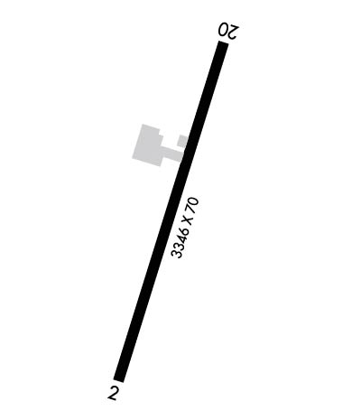
| Lat: N 3413.9 Long: W 09017.4 Elev: 162 Var: -01 Longest Runway: 3346 | ||
| CTAF: 122.9 | ||
| ||||||||||||||||||||||||||||||||
| ||||||||||||||||||||||||||||||||
| Rwy | Rwy | |||||||
| 3346x70 | 3346' | 3346x70 | 3346' | |||||
| Runway ID | Single Wheel | Double Wheel | Double Tandem Wheel | Dual Double Wheel |
| 02/20 | 10,000 | N/A | N/A | N/A |
| These numbers are Advisory and are not limits. The Airport Manager should have more accurate Weight Limits | ||||
 Airport Diagram might not be current. | |
| Facility Name: | SELFS |
| City Name: | MARKS |
| County: | QUITMAN |
| State abbrev: | MS |
| State Name: | MISSISSIPPI |
| Ownership: | PUBLICLY OWNED |
| Use: | OPEN TO THE PUBLIC |
| Owner's Name: | QUITMAN COUNTY |
| Address: | 230 CHESTNUT ST |
| MARKS, MS 38646 | |
| Owner's Phone: | 662-326-3161 |
| Manager's Name: | KEVIN RUSHING |
| Address: | 733 AIRPORT RD, PO BOX 370 |
| MARKS, MS 38646 | |
| Phone: | 662-444-4736 |
| FAA Region: | SOUTHERN |
| FAA Field Office: | JAN |
| Date | Sunrise | Sunset |
|---|---|---|
| 06/08/26 Monday | 5:49 | 20:12 |
| 06/09/26 Tuesday | 5:49 | 20:12 |
| 06/10/26 Wednesday | 5:49 | 20:13 |
| 06/11/26 Thursday | 5:49 | 20:13 |
| 06/12/26 Friday | 5:49 | 20:13 |
| 06/13/26 Saturday | 5:49 | 20:14 |
| 06/14/26 Sunday | 5:49 | 20:14 |
| 06/15/26 Monday | 5:49 | 20:15 |
| 06/16/26 Tuesday | 5:49 | 20:15 |
| 06/17/26 Wednesday | 5:49 | 20:15 |
| 06/18/26 Thursday | 5:49 | 20:15 |
| 06/19/26 Friday | 5:49 | 20:16 |
| 06/20/26 Saturday | 5:49 | 20:16 |
| 06/21/26 Sunday | 5:50 | 20:16 |
| Airport Attendance Schedule | MON-FRI 0800-1700, SAT-SUN IRREG; FOR ATNDNC HRS SAT & SUN CALL 662-444-4736. |
| Airport Status | OPERATIONAL (This Status can change at any time - please check NOTAMS) |
| Airport Lighting Schedule | SS-SR |
| Airport Storage Available | Tie Downs |
| Extra Services Available | Crop Dusting |
| Wind Indicator | YES - (unlit) |
| Control Tower | NO |
| CTAF Frequency | 122.900 |
| Unicom Frequency | |
| Rotating Beacon Color | |
| Segmented Circle | NO |
| Landing Fee | NO |
| Airport Inspected | STATE - performed by STATE AERONAUTICAL PERSONNEL |
| Inspection Date | 02/07/2025 |
| Type of Fuel Available | None |
| Airframe Repair Service | MAJOR |
| Power Plant Repair Service | MAJOR |
| Latitude | N3413.9 |
| Longitude | W09017.4 (ESTIMATED) |
| Arpt Elevation | 161ft (SURVEYED) |
| Magnetic Variation | 01E |
| 2 miles SW | of MARKS |
| Traffic Pattern Altitude | |
| Sectional Chart | MEMPHIS |
| Operations (Reported) | Yearly | Avg. Daily |
|---|---|---|
| General Aviation Transient | 0 | 0 |
| General Aviation Local | 0 | 0 |
| Air Taxi | 0 | 0 |
| Commerical | 0 | 0 |
| Commuter | 0 | 0 |
| Military | 0 | 0 |
| Aircraft based on Field | |
|---|---|
| General Aviation Singles | 0 |
| General Aviation Multi | 0 |
| Jet Aircraft | 0 |
| General Aviation Helicopters | 0 |
| Military Aircraft | 0 |
| Gliders | 0 |
| Ultralights | 0 |
| FSS on field | NO |
| FSS tie-in | GREENWOOD |
| FSS Phone | 1-800-WX-BRIEF |
| Who issues Notams | GWO |
| Notam D service at airport | YES |
| ARTCC Name | MEMPHIS |
| Airport Certification | |
| Aircraft Rescue & Firefighting Index | None |
| Airport of Entry | No |
| Custom Landing Rights | No |
| Joint Civil/Military | No |
| Military Landing rights | No |
| FOR CD CTC MEMPHIS ARTCC AT 901-368-8453/8449. |
Airport Communications & Frequencies:
| |||||||
| Runway: 02 | Runway: 20 | ||
| Mag heading: | 16° | Mag heading: | 196° |
| Rwy Slope: | -.01% Down | Rwy Slope: | .01% Up |
| Approach: | Approach: | ||
| Pattern: | Left Traffic | Pattern: | Left Traffic |
| Markings: | NONPRECISION INSTRUMENT | Markings: | NONPRECISION INSTRUMENT |
| Marking Condition: | POOR; MARKINGS BADLY FADED. | Marking Condition: | FAIR |
| Arresting Dev: | Arresting Dev: | ||
| Lat & Long: | N3413.6 W09017.5 | Lat. & Long.: | N3414.2 W09017.3 |
| Elev: | 160.8 ft. MSL | Elev: | 160.5 ft. MSL |
| TCH: | TCH: | ||
| Visual Glide Path: | Visual Glide Path: | ||
| Displaced Threshold: | No | Displaced Threshold: | No |
| Touchdown Zone: | YES | Touchdown Zone: | YES |
| Touchdown Elev.: | 161.7 feet | Touchdown Elev.: | 161.7 feet |
| Visual Glide Slope: | Visual Glide Slope: | ||
| RVR Equipment: | RVR Equipment: | ||
| RVV Equipment: | NO | RVV Equipment: | NO |
| Approach Lights: | Approach Lights: | ||
| REIL: | NO | REIL: | NO |
| Centerline Lights: | NO | Centerline Lights: | NO |
| Touchdown lights: | NO | Touchdown lights: | NO |
| Runway Category: | Runway with a Non-precision Approach | Runway Category: | Runway with a Non-precision Approach |
| Declared Distances: | Declared Distances: | ||
| Obstructions: | Obstructions: | TREES | |
| Marked: | Marked: | NOT Marked/Lighted | |
| Clearance slope: | 50:1 | Clearance slope: | 20:1 |
| Obstruction height: | Obstruction height: | 71 feet AGL | |
| Dist. from runway: | Dist. from runway: | 1750 feet | |
| Centerline offset: | Centerline offset: | 300 feet right of centerline | |
| Comments: | Comments: | PAVED RD 160 FT FM THR. |
Thanks for using FltPlan.com
all rights reserved © 1999-2026 by Flight Plan LLC
