
| SOUTHWEST MINNESOTA REGL MARSHALL MN |
| |
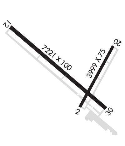
| Lat: N 4427.1 Long: W 09549.5 Elev: 1183 Var: -05 Longest Runway: 7221 | ||
| Clr Del: 121.72 GCO AWOS: 111.0 CTAF: 122.8 | ||
| ||||||
| ||||||
|
| Rwy | Rwy | |||||||
| 3999x75 | 3999' | 3999x75 | 3999' | |||||
| 7221x100 | 7221' | 109.70 - 124° | 7221x100 | 7221' | ||||
| Runway ID | Single Wheel | Double Wheel | Double Tandem Wheel | Dual Double Wheel |
| 02/20 | N/A | N/A | N/A | N/A |
| 12/30 | 72,000 | 105,000 | N/A | N/A |
| These numbers are Advisory and are not limits. The Airport Manager should have more accurate Weight Limits | ||||
 Airport Diagram might not be current. | |
| Facility Name: | SOUTHWEST MINNESOTA RGNL MARSHALL/RYAN FLD |
| City Name: | MARSHALL |
| County: | LYON |
| State abbrev: | MN |
| State Name: | MINNESOTA |
| Ownership: | PUBLICLY OWNED |
| Use: | OPEN TO THE PUBLIC |
| Owner's Name: | CITY OF MARSHALL |
| Address: | 344 W MAIN ST |
| MARSHALL, MN 56258-1313 | |
| Owner's Phone: | 507-537-6760 |
| Manager's Name: | JASON ANDERSON |
| Address: | 344 W MAIN ST |
| MARSHALL, MN 56258-1313 | |
| Phone: | 507-537-6773 |
| FAA Region: | GREAT LAKES |
| FAA Field Office: | DMA |
| Date | Sunrise | Sunset |
|---|---|---|
| 06/08/26 Monday | 5:39 | 21:06 |
| 06/09/26 Tuesday | 5:39 | 21:06 |
| 06/10/26 Wednesday | 5:39 | 21:07 |
| 06/11/26 Thursday | 5:38 | 21:08 |
| 06/12/26 Friday | 5:38 | 21:08 |
| 06/13/26 Saturday | 5:38 | 21:09 |
| 06/14/26 Sunday | 5:38 | 21:09 |
| 06/15/26 Monday | 5:38 | 21:10 |
| 06/16/26 Tuesday | 5:38 | 21:10 |
| 06/17/26 Wednesday | 5:38 | 21:10 |
| 06/18/26 Thursday | 5:38 | 21:11 |
| 06/19/26 Friday | 5:38 | 21:11 |
| 06/20/26 Saturday | 5:38 | 21:11 |
| 06/21/26 Sunday | 5:39 | 21:11 |
| Airport Attendance Schedule | MON-THU 0800-1700; FOR SVC AFT HRS CALL 507-532-3164. |
| Airport Status | OPERATIONAL (This Status can change at any time - please check NOTAMS) |
| Airport Lighting Schedule | ACTVT MALSR RWY 12; MALSF RWY 30; REIL RWY 02 & 20; PAPI RWY 12, 30, 02, & 20; HIRL RWY 12/30; MIRL RWY 02/20 - CTAF. |
| Airport Storage Available | Tie Downs, Hanger |
| Extra Services Available | Air Freight, Crop Dusting, Air Ambulance, Charter, Flight Instruction, Aircraft Rental, Aircraft Sales |
| Wind Indicator | YES - (lighted) |
| Control Tower | NO |
| CTAF Frequency | 122.800 |
| Unicom Frequency | 122.800 |
| Rotating Beacon Color | WG |
| Segmented Circle | NO |
| Landing Fee | NO |
| Airport Inspected | STATE - performed by STATE AERONAUTICAL PERSONNEL |
| Inspection Date | 08/14/2025 |
| Type of Fuel Available | Grade 100LL, JET A (freeze point -40C); -10FUEL AVBL H24 SELF SVC VIA CREDIT CARD. |
| Airframe Repair Service | MAJOR |
| Power Plant Repair Service | MAJOR |
| Latitude | N4427.1 |
| Longitude | W09549.5 (ESTIMATED) |
| Arpt Elevation | 1182ft (SURVEYED) |
| Magnetic Variation | 05E |
| 1 miles W | of MARSHALL |
| Traffic Pattern Altitude | |
| Sectional Chart | OMAHA |
| Operations (Reported) | Yearly | Avg. Daily |
|---|---|---|
| General Aviation Transient | 0 | 0 |
| General Aviation Local | 0 | 0 |
| Air Taxi | 0 | 0 |
| Commerical | 0 | 0 |
| Commuter | 0 | 0 |
| Military | 0 | 0 |
| Aircraft based on Field | |
|---|---|
| General Aviation Singles | 0 |
| General Aviation Multi | 0 |
| Jet Aircraft | 0 |
| General Aviation Helicopters | 0 |
| Military Aircraft | 0 |
| Gliders | 0 |
| Ultralights | 0 |
| FSS on field | NO |
| FSS tie-in | PRINCETON |
| FSS Phone | 1-800-WX-BRIEF |
| Who issues Notams | MML |
| Notam D service at airport | YES |
| ARTCC Name | MINNEAPOLIS |
| Airport Certification | |
| Aircraft Rescue & Firefighting Index | None |
| Airport of Entry | No |
| Custom Landing Rights | No |
| Joint Civil/Military | No |
| Military Landing rights | YES |
| NATIONAL PLAN OF INTEGRATED AIRPORT SYSTEMS (NPIAS) |
| GRANT AGREEMENTS UNDER FAAP/ADAP/AIP |
| ASSURANCES PURSUANT TO TITLE VI, CIVIL RIGHTS ACT OF 1964 |
| GCO AVBL ON FREQ 121.725 THRU MINNEAPOLIS ARTCC & FLT SVCS. |
| FOR CD IF UNA TO CTC ON FSS FREQ, CTC MINNEAPOLIS ARTCC AT 651-463-5588. |
Airport Communications & Frequencies:
| |||||||||
| Runway: 02 | Runway: 20 | ||
| Mag heading: | 23° | Mag heading: | 203° |
| Rwy Slope: | -.20% Down | Rwy Slope: | .20% Up |
| Approach: | Approach: | ||
| Pattern: | Left Traffic | Pattern: | Left Traffic |
| Markings: | NONPRECISION INSTRUMENT | Markings: | NONPRECISION INSTRUMENT |
| Marking Condition: | FAIR | Marking Condition: | FAIR |
| Arresting Dev: | Arresting Dev: | ||
| Lat & Long: | N4426.8 W09549.3 | Lat. & Long.: | N4427.3 W09548.9 |
| Elev: | 1179.9 ft. MSL | Elev: | 1172.0 ft. MSL |
| TCH: | 32 ft. AGL | TCH: | 57 ft. AGL |
| Visual Glide Path: | 3.00 degrees | Visual Glide Path: | 3.00 degrees |
| Displaced Threshold: | No | Displaced Threshold: | No |
| Touchdown Zone: | YES | Touchdown Zone: | YES |
| Touchdown Elev.: | 1180.1 feet | Touchdown Elev.: | 1178.1 feet |
| Visual Glide Slope: | 4-Light PAPI on LEFT side of Runway | Visual Glide Slope: | 4-Light PAPI on LEFT side of Runway |
| RVR Equipment: | RVR Equipment: | ||
| RVV Equipment: | NO | RVV Equipment: | NO |
| Approach Lights: | Approach Lights: | ||
| REIL: | YES | REIL: | YES |
| Centerline Lights: | NO | Centerline Lights: | NO |
| Touchdown lights: | NO | Touchdown lights: | NO |
| Runway Category: | Runway with a Visual Approach | Runway Category: | Runway with a Visual Approach |
| Declared Distances: | Declared Distances: |
| Runway: 12 | Runway: 30 | ||
| Mag heading: | 125° | Mag heading: | 305° |
| Rwy Slope: | -.06% Down | Rwy Slope: | .06% Up |
| Approach: | ILS | Approach: | |
| Pattern: | Left Traffic | Pattern: | Left Traffic |
| Markings: | PRECISION INSTRUMENT | Markings: | PRECISION INSTRUMENT |
| Marking Condition: | GOOD | Marking Condition: | GOOD |
| Arresting Dev: | Arresting Dev: | ||
| Lat & Long: | N4427.5 W09550.3 | Lat. & Long.: | N4426.8 W09549.0 |
| Elev: | 1182.6 ft. MSL | Elev: | 1178.5 ft. MSL |
| TCH: | 50 ft. AGL | TCH: | 32 ft. AGL |
| Visual Glide Path: | 3.00 degrees | Visual Glide Path: | 3.00 degrees |
| Displaced Threshold: | No | Displaced Threshold: | No |
| Touchdown Zone: | YES | Touchdown Zone: | YES |
| Touchdown Elev.: | 1182.8 feet | Touchdown Elev.: | 1179.4 feet |
| Visual Glide Slope: | 4-Light PAPI on LEFT side of Runway | Visual Glide Slope: | 4-Light PAPI on LEFT side of Runway |
| RVR Equipment: | RVR Equipment: | ||
| RVV Equipment: | NO | RVV Equipment: | NO |
| Approach Lights: | MALSR - 1,400 foot medium intensity approach lighting system with runway alignment indicator lights | Approach Lights: | MALSF - 1,400 foot medium intensity approach lighting system with sequenced flashers |
| REIL: | NO | REIL: | NO |
| Centerline Lights: | NO | Centerline Lights: | NO |
| Touchdown lights: | NO | Touchdown lights: | NO |
| Runway Category: | Precision Instrument Runway | Runway Category: | D |
| Declared Distances: | Declared Distances: | ||
| Obstructions: | Obstructions: | CROPS | |
| Marked: | Marked: | NOT Marked/Lighted | |
| Clearance slope: | 50:1 | Clearance slope: | 12:1 |
| Obstruction height: | Obstruction height: | 9 feet AGL | |
| Dist. from runway: | Dist. from runway: | 319 feet | |
| Centerline offset: | Centerline offset: | 354 feet right of centerline | |
| Comments: | Comments: |
Thanks for using FltPlan.com
all rights reserved © 1999-2026 by Flight Plan LLC
