
| MCMINN COUNTY ATHENS TN |
| |
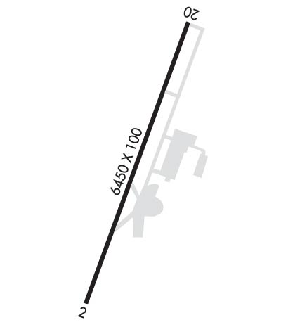
| Lat: N 3524.0 Long: W 08433.7 Elev: 874 Var: +03 Longest Runway: 6450 | ||
| AWOS: 125.42 CTAF: 122.8 | ||
| ||||||
| ||||||
|
| Rwy | Rwy | |||||||
| 6450x100 | 5501' | 6450x100 | 6450' | |||||
| Runway ID | Single Wheel | Double Wheel | Double Tandem Wheel | Dual Double Wheel |
| 02/20 | 30,000 | 42,000 | N/A | N/A |
| These numbers are Advisory and are not limits. The Airport Manager should have more accurate Weight Limits | ||||
 Airport Diagram might not be current. | |
| Facility Name: | MCMINN COUNTY |
| City Name: | ATHENS |
| County: | MC MINN |
| State abbrev: | TN |
| State Name: | TENNESSEE |
| Ownership: | PUBLICLY OWNED |
| Use: | OPEN TO THE PUBLIC |
| Owner's Name: | MCMINN COUNTY |
| Address: | COUNTY COURTHOUSE, 6 EAST MADISON AVENUE |
| ATHENS, TN 37303 | |
| Owner's Phone: | 423-745-7634 |
| Manager's Name: | KRISTY GENTRY COX |
| Address: | 195 COUNTY ROAD 552 |
| ATHENS, TN 37303 | |
| Phone: | 423-745-4939 |
| FAA Region: | SOUTHERN |
| FAA Field Office: | MEM |
| Date | Sunrise | Sunset |
|---|---|---|
| 09/24/21 Friday | 7:28 | 19:32 |
| 09/25/21 Saturday | 7:28 | 19:31 |
| 09/26/21 Sunday | 7:29 | 19:30 |
| 09/27/21 Monday | 7:30 | 19:28 |
| 09/28/21 Tuesday | 7:31 | 19:27 |
| 09/29/21 Wednesday | 7:31 | 19:25 |
| 09/30/21 Thursday | 7:32 | 19:24 |
| 10/01/21 Friday | 7:33 | 19:22 |
| 10/02/21 Saturday | 7:34 | 19:21 |
| 10/03/21 Sunday | 7:34 | 19:20 |
| 10/04/21 Monday | 7:35 | 19:18 |
| 10/05/21 Tuesday | 7:36 | 19:17 |
| 10/06/21 Wednesday | 7:37 | 19:15 |
| 10/07/21 Thursday | 7:38 | 19:14 |
| Airport Attendance Schedule | SUN 1230-0500, MON-SAT 0830-0500; CLOSED EASTER, THANKSGIVING, AND CHRISTMAS. |
| Airport Status | OPERATIONAL (This Status can change at any time - please check NOTAMS) |
| Airport Lighting Schedule | SS-SR |
| Airport Storage Available | Tie Downs, Hanger |
| Extra Services Available | Flight Instruction |
| Wind Indicator | YES - (lighted) |
| Control Tower | NO |
| CTAF Frequency | 122.800 |
| Unicom Frequency | 122.800 |
| Rotating Beacon Color | CLEAR-GREEN (Light Land Airport) |
| Segmented Circle | YES |
| Landing Fee | NO |
| Airport Inspected | STATE - performed by STATE AERONAUTICAL PERSONNEL |
| Inspection Date | 06/16/2020 |
| Type of Fuel Available | Grade 100LL, JET A |
| Airframe Repair Service | MAJOR |
| Power Plant Repair Service | MAJOR |
| Latitude | N3524.0 |
| Longitude | W08433.7 (ESTIMATED) |
| Arpt Elevation | 874ft (ESTIMATED) |
| Magnetic Variation | 03W |
| 3 miles SE | of ATHENS |
| Traffic Pattern Altitude | |
| Sectional Chart | ATLANTA |
| Operations (Reported) | Yearly | Avg. Daily |
|---|---|---|
| General Aviation Transient | 6000 | 16 |
| General Aviation Local | 15000 | 41 |
| Air Taxi | 1500 | 4 |
| Commerical | 0 | 0 |
| Commuter | 0 | 0 |
| Military | 75 | 0 |
| Aircraft based on Field | |
|---|---|
| General Aviation Singles | 33 |
| General Aviation Multi | 2 |
| Jet Aircraft | 1 |
| General Aviation Helicopters | 0 |
| Military Aircraft | 0 |
| Gliders | 0 |
| Ultralights | 0 |
| FSS on field | NO |
| FSS tie-in | NASHVILLE |
| FSS Phone | 1-800-WX-BRIEF |
| Who issues Notams | BNA |
| Notam D service at airport | YES |
| ARTCC Name | ATLANTA |
| Airport Certification | |
| Aircraft Rescue & Firefighting Index | None |
| Airport of Entry | No |
| Custom Landing Rights | No |
| Joint Civil/Military | No |
| Military Landing rights | YES |
| NATIONAL PLAN OF INTEGRATED AIRPORT SYSTEMS (NPIAS) |
| GRANT AGREEMENTS UNDER FAAP/ADAP/AIP |
| ASSURANCES PURSUANT TO TITLE VI, CIVIL RIGHTS ACT OF 1964 |
| WILDLIFE ON AND INVOF ARPT. |
| FOR CD CTC KNOXVILLE APCH AT 865-980-3034; IF UNA FOR CD CTC KNOXVILLE APCH AT 865-980-3033. |
Airport Communications & Frequencies:
| ||||||||||||||
| Runway: 02 | Runway: 20 | ||
| Mag heading: | 22° | Mag heading: | 202° |
| Rwy Slope: | 1.05% Up | Rwy Slope: | -1.05% Down |
| Approach: | Approach: | ||
| Pattern: | Left Traffic | Pattern: | Left Traffic |
| Markings: | NONPRECISION INSTRUMENT | Markings: | NONPRECISION INSTRUMENT |
| Marking Condition: | POOR | Marking Condition: | POOR |
| Arresting Dev: | Arresting Dev: | ||
| Lat & Long: | N3523.4 W08433.9 | Lat. & Long.: | N3524.5 W08433.5 |
| Elev: | 806.5 ft. MSL | Elev: | 874.3 ft. MSL |
| TCH: | 50 ft. AGL | TCH: | 50 ft. AGL |
| Visual Glide Path: | 3.00 degrees | Visual Glide Path: | 3.00 degrees |
| Displaced Threshold: | 949 feet | Displaced Threshold: | No |
| Touchdown Zone: | YES | Touchdown Zone: | YES |
| Touchdown Elev.: | 845.9 feet | Touchdown Elev.: | 874.3 feet |
| Visual Glide Slope: | 2-Light PAPI on LEFT side of Runway | Visual Glide Slope: | 2-Light PAPI on LEFT side of Runway |
| RVR Equipment: | RVR Equipment: | ||
| RVV Equipment: | NO | RVV Equipment: | NO |
| Approach Lights: | Approach Lights: | ||
| REIL: | YES | REIL: | YES |
| Centerline Lights: | NO | Centerline Lights: | NO |
| Touchdown lights: | NO | Touchdown lights: | NO |
| Runway Category: | Runway with a Non-precision Approach having visibility minimums greater than 3/4 mile | Runway Category: | Runway with a Non-precision Approach having visibility minimums greater than 3/4 mile |
| Declared Distances: | Declared Distances: | ||
| Obstructions: | TREES | Obstructions: | TREES |
| Marked: | NOT Marked/Lighted | Marked: | NOT Marked/Lighted |
| Clearance slope: | 14:1; APCH SLOPE 36:1 TO DISPLCD THLD. | Clearance slope: | 17:1 |
| Obstruction height: | 72 feet AGL | Obstruction height: | 59 feet AGL |
| Dist. from runway: | 1244 feet | Dist. from runway: | 1258 feet |
| Centerline offset: | 311 left of centerline | Centerline offset: | 52 feet left of centerline |
| Comments: | Comments: |
Thanks for using FltPlan.com
all rights reserved © 1999-2021 by Flight Plan LLC
